


by David Moran, on Oct 4, 2016 12:52:41 PM
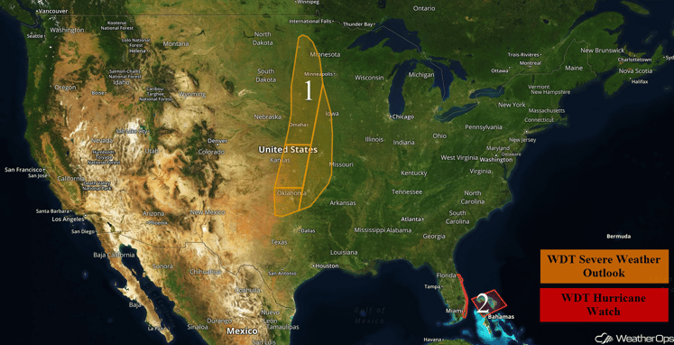
A strong upper level trough and surface low moving over the Plains will allow for the development of thunderstorms across portions of the Plains on Tuesday. Within this threat region, severe thunderstorms are expected across portions of Kansas, Missouri, and Oklahoma. Across portions of Montana and Wyoming, snow will be possible on the backside of the low moving into the Plains. Thunderstorms are expected across portions of the Central Plains on Wednesday as a cold front moves eastward. Snow will continue across the Northern Rockies. Tropical storm conditions will be possible across portions of southern Florida as Hurricane Matthew moves through the Bahamas. A new area of low pressure will develop across the Plains on Thursday, allowing for the development for strong to severe thunderstorms across portions of the Central Plains.
US Hazards
Region 1
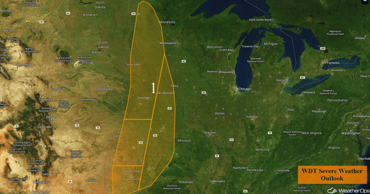
A region of instability covers most of the Great Plains, from Central Minnesota to Southern Oklahoma on Tuesday. A surface Low and associated cold front and dryline will bring storms to the region, with further north having a mostly linear threat and the further south having the potential for discrete cells. All modes of severe weather are possible throughout this region, particularly in the Central and Southern portions.
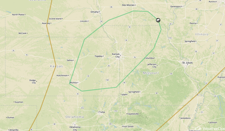
Update 2:52pm CDT: Tornado Watch in effect for portions of Kansas and Nebraska until 9pm CDT. Large hail in excess of 2 inches, damaging winds in excess of 70 mph and tornadoes will be possible.
 Tornado Watch Outline
Major Cities in Region: Sioux Falls, SD, Omaha, NE, Kansas City, MO, Wichita, KS, Oklahoma City, OK
Region 1
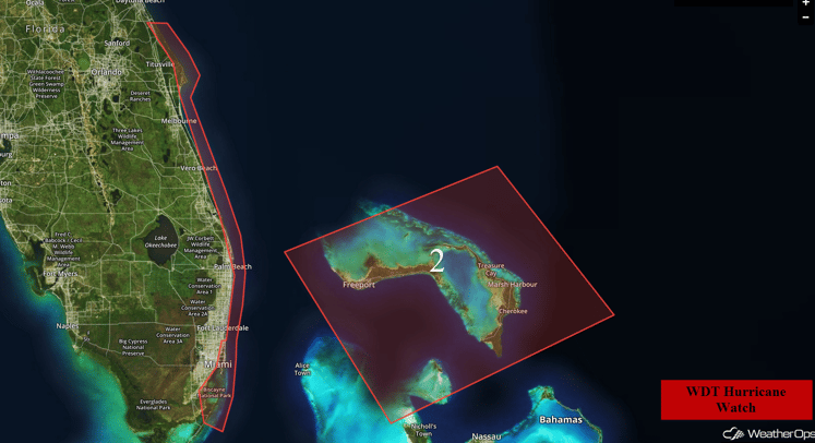
Region 2
The Bahamas and the Eastern Coast of Florida remain in immediate threat of Hurricane Mathew. The storm will begin to affect the region from Wednesday to Thursday and will likely maintain its strength through its interaction with the Haiti and Cuba.
Major Cities in Region: Orlando, FL, Melbourne, FL, Palm Beach, FL, Miami, FL
Region 2
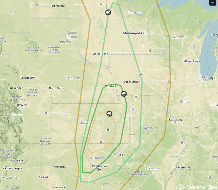
Scattered Severe Thunderstorms Likely Across the Great Plains Today
A strong upper-level low will dig into the Great Plains on Tuesday. Ahead of this trough, a deepening surface low over the northern Great Plains will allow for warm moist air to move into the Southern Great Plains. Given the strong instability in place, as well as wind shear from a strong jet stream over the region, some of these thunderstorms will likely become supercells. All modes of severe weather are possible including strong wind, large hail, and tornadoes. By evening, thunderstorms should merge into a squall line, and the main threat will shift towards damaging wind gusts as storms push east into northeastern Oklahoma, eastern Kansas, and western Missouri.
Outside of the main threat area, severe storms will still be possible across much of the rest of the Great Plains, though the threat will be generally lower. Over the Northern Great Plains, a few severe storms will be possible with large hail and damaging winds as the main hazard.
Major Cities in Region: Omaha, NE, Wichita, KS, Oklahoma City, OK
SPC Convective Outlook for Tuesday
High Elevation Snowfall Possible in Montana and Wyoming Today
Precipitation on the west side of a surface low will transition to snow above 4,500 feet on Tuesday as cold air moves south out of Canada. Snowfall accumulations should generally be light, around 2-4 inches in mountainous locations with a few locations possibly seeing over 6 inches of snow.
Major Cities in Region: Great Falls, MO, Billings, MO, Cody, WY
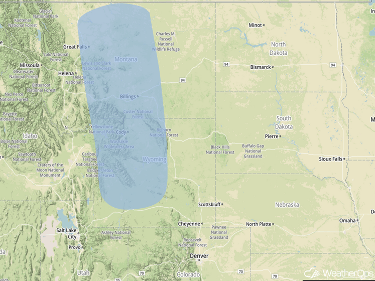
Significant Snowfall Risk Outline for Tuesday
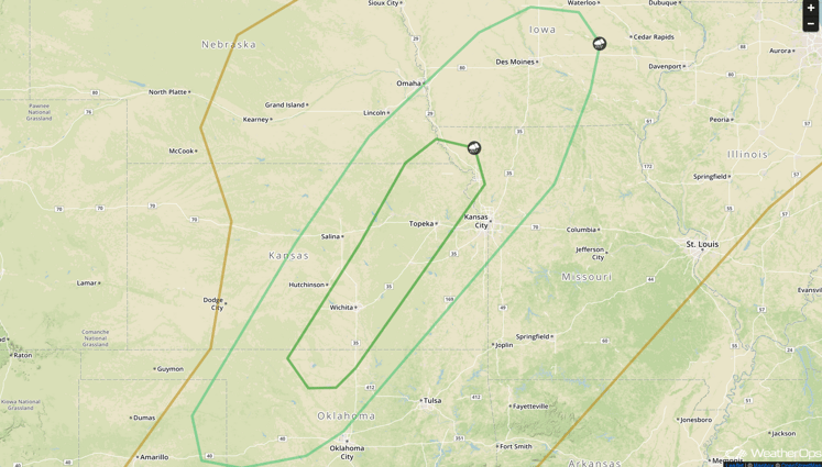
Strong to Severe Thunderstorms Possible in the Central Plains Tomorrow
Thunderstorms are expected to be ongoing Wednesday morning ahead of a cold front moving through the region. By afternoon, moderate instability and wind shear across the region should allow for a few thunderstorms to become strong to severe, with large hail and damaging winds to be the main hazards.
Major Cities in Region: Kansas City, MO, Topeka, KS, Wichita, KS
SPC Convective Outlook for Wednesday
Locally Heavy Snowfall Possible in the Northern Rockies on Wednesday
Additional snow shows are expected above 6,000 feet in the Northern Rocky Mountains on Wednesday. The heaviest snows are expected in northwestern Wyoming into southern Montana where widespread accumulations of 2-4 inches are expected, with locally higher amounts in excess of 6 inches possible. This will bring the 48-hour totals to 4-8 inches across much of the Northern Rockies by the end of Wednesday.
Major Cities in Region: Kansas City, MO, Topeka, KS, Wichita, KS
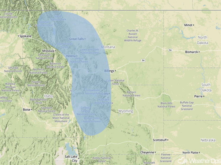
Significant Snowfall Risk Outline for Wednesday
Thunderstorms Possible in the Central Plains on Thursday
Thunderstorms are expected to develop on Thursday ahead of a developing surface low. Conditions will be favorable for a few of these thunderstorms to become severe, with large hail and damaging wind gusts expected to be the main hazards. In addition to the threat for strong to severe thunderstorms, heavy rainfall will be possible. Wide spread rainfall accumulations of 1-3 inches can be expected across western and central Oklahoma and eastern Kansas, with locally higher amounts in excess of 3 inches possible in some locations.
Major Cities in Region: Topeka, KS, Wichita, KS
SPC Convective Outlook for Thursday
Tropical Update
Hurricane Matthew (green circle) is currently moving over southwestern Haiti, and will continue roughly northward today. It should move over parts of eastern Cuba and into the Bahamas later today and tonight. The storm is expected to move to the northwest after that, and its center is forecast to eventually come very close to the southeastern US. It should be noted that the envelope of uncertainty with the track covers most of the Florida Peninsula, and eastern portions of Georgia, and the Carolinas, which means that there is at least some chance Matthew could come ashore in those areas.
Farther to the east, Tropical Storm Nicole (red circle) remains disorganized, but continues to produce showers and thunderstorms. This system may develop further in the next 12-24 hour or so until it moves into an area with higher shear. The system’s forecast path is highly uncertain because of interactions with Hurricane Matthew. Elsewhere in the region, there are no other imminent tropical cyclone threats.
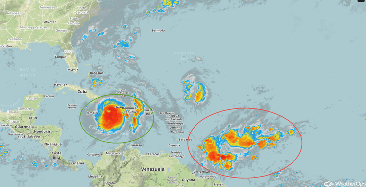
Tropical Infrared Satellite
A Look Ahead
Hurricane Matthew will need to be monitored along the East Coast by the end of the week with the potential for tropical storm conditions along the coast. Elsewhere, thunderstorms will be possible for portions of the Plains Friday as an area of low pressure and cold front moves across the region.
This is just a brief look at current weather hazards. We can provide you site-specific forecast information for the purpose of protecting your personnel and assets. Try a 7-day demo right away and learn how timely precision weather information can enhance your bottom line.

