


by David Moran, on May 15, 2018 11:11:33 AM
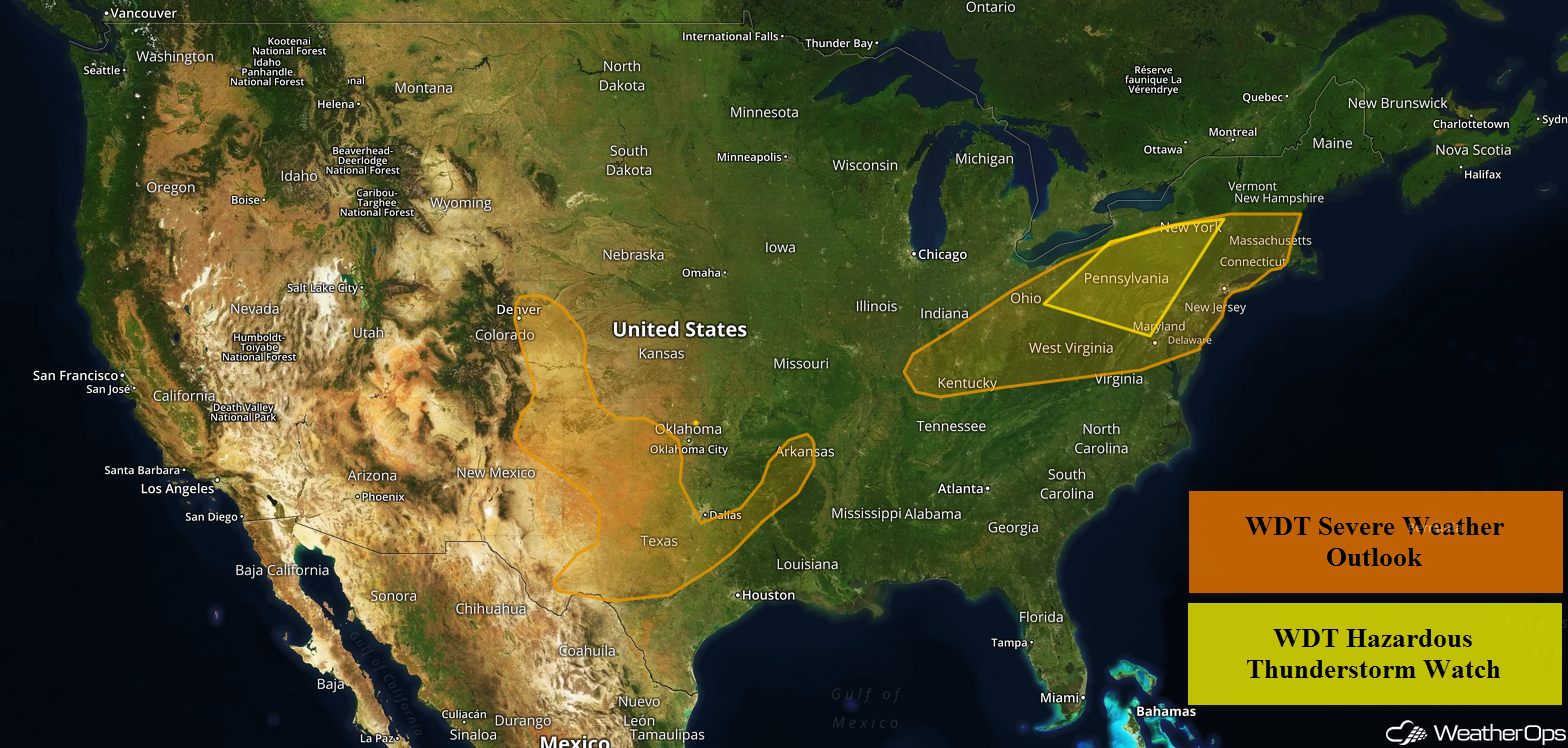
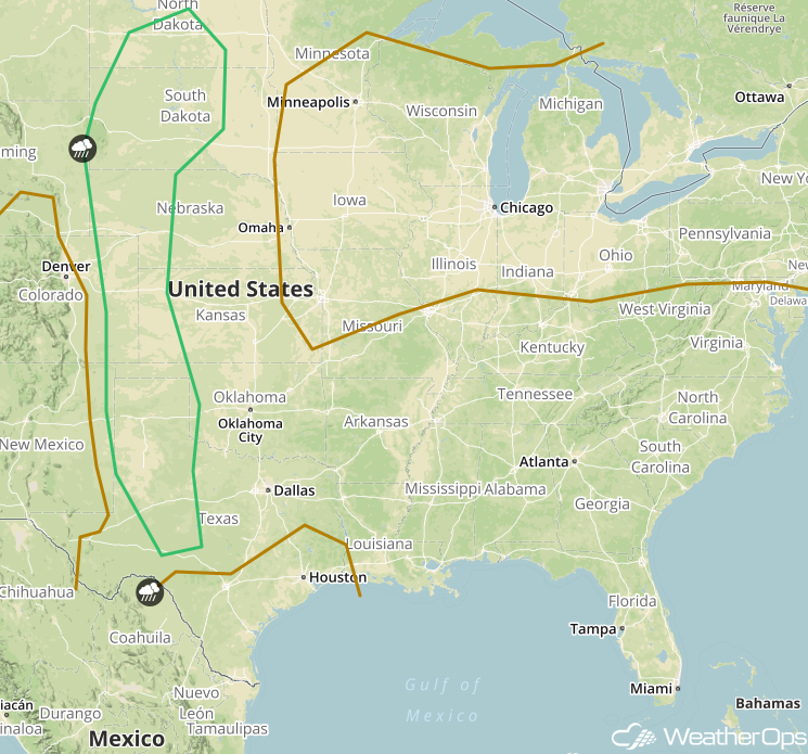
Thunderstorms may develop across the Northeast on Tuesday as a warm front moves northward. The potential for thunderstorms will continue across the Southern Plains ahead of a dry line. There will be a risk for excessive rainfall along portions of the Atlantic Coast.
- Thunderstorm Risk across the Northeast on Tuesday
- Potential for Thunderstorms Tuesday across the Southern Plains
- Excessive Rainfall for the Atlantic Coast Tuesday
- Thunderstorms on Wednesday for the High Plains
- Thunderstorm Potential for the Central Plains Thursday
- Tropical Update
 US Hazards

Thunderstorm Risk across the Northeast on Tuesday
A warm front is forecast to lift through the region, allowing moisture to increase. With daytime heating, instability will increase as well. This instability, combined with strong shear, will allow for the development of severe thunderstorms; some of which may become supercells. Damaging winds, along with large hail and tornadoes, will be potential hazards. In addition, frequent lightning and heavy rainfall are expected.
Major Cities in Region: Philadelphia, PA, New York, NY, Boston, MA
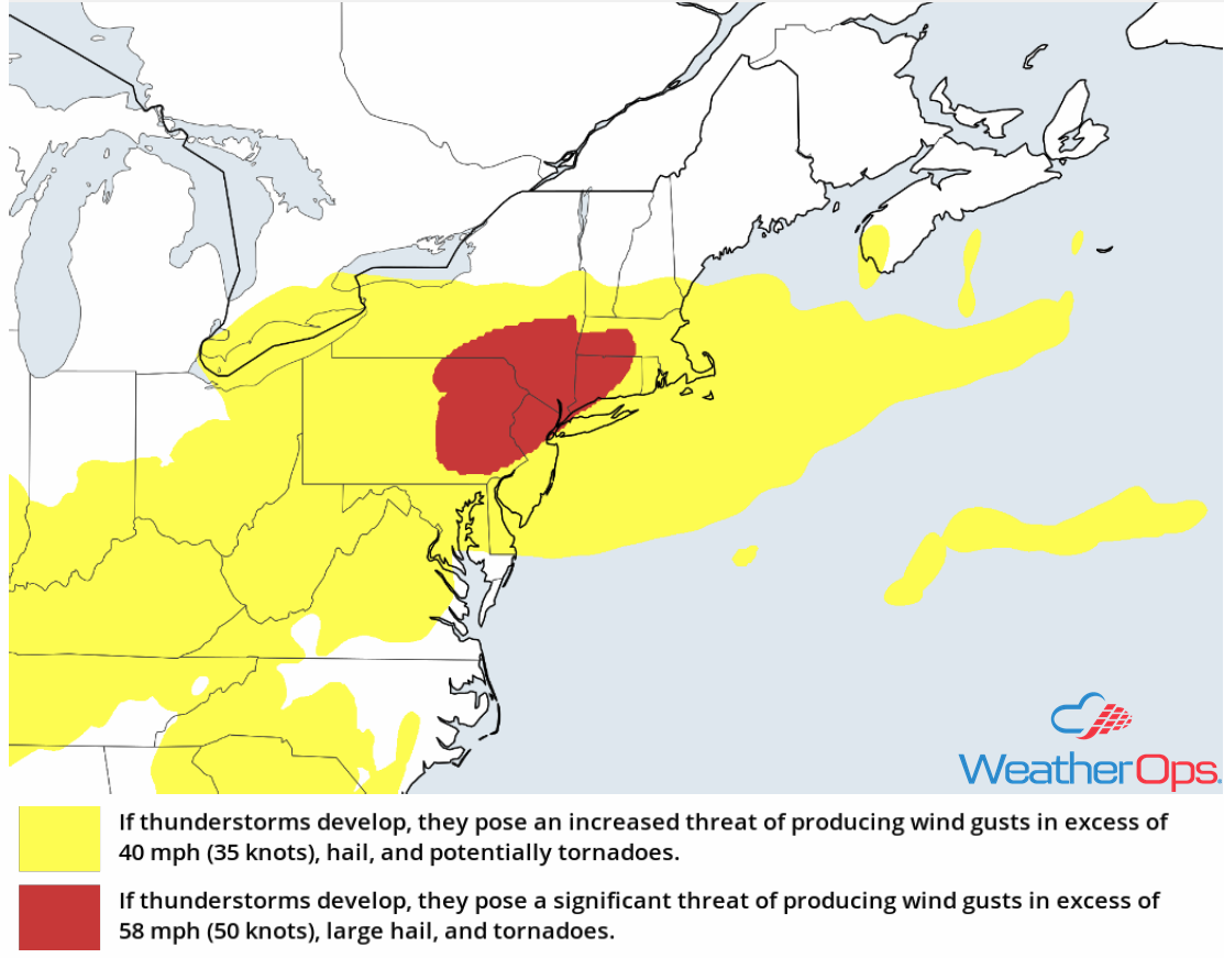 Thunderstorm Risk for Tuesday
Potential for Thunderstorms Tuesday across the Southern Plains
Instability is forecast to build through the afternoon, allowing for the development of thunderstorms ahead of a dry line. With strong vertical wind shear, thunderstorms may evolve into a line. Damaging winds and large hail will be the primary hazards with these storms, but some storms may produce frequent lightning and heavy rain.
Major Cities in Region: Amarillo, TX, Abilene, TX, Austin, TX, Oklahoma City, OK, Dallas, TX
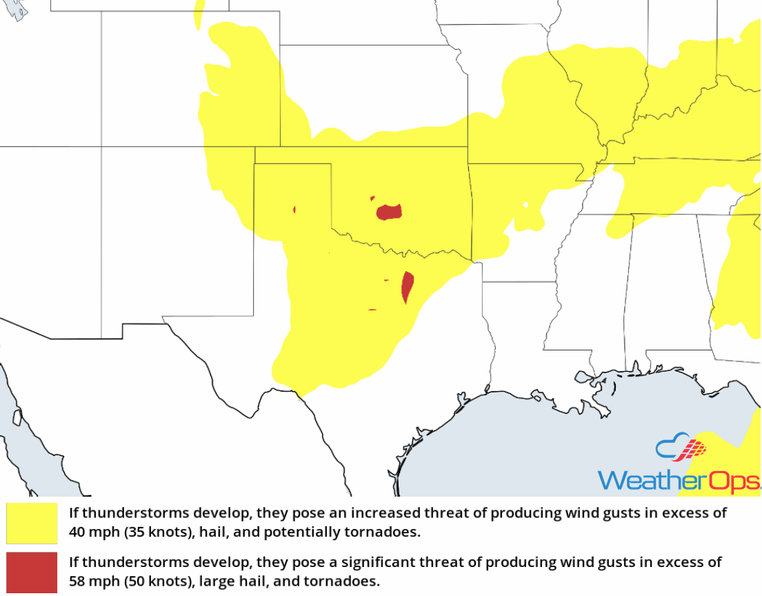 Thunderstorm Risk for Tuesday
Excessive Rainfall for the Atlantic Coast Tuesday
With increasing moisture associated with a warm front lifting northward, thunderstorm activity is forecast to develop during the afternoon hours. A cold front will progress to the east-southeast in the afternoon and stall over the area by the evening. Thunderstorms are forecast to continue into the evening, leading to the potential for heavy to excessive rainfall. Total rainfall accumulations between 1-2 inches with locally higher amounts in excess of 3 inches are expected.
Major Cities in Region: Atlantic City, NJ, New York, NY, Boston, MA
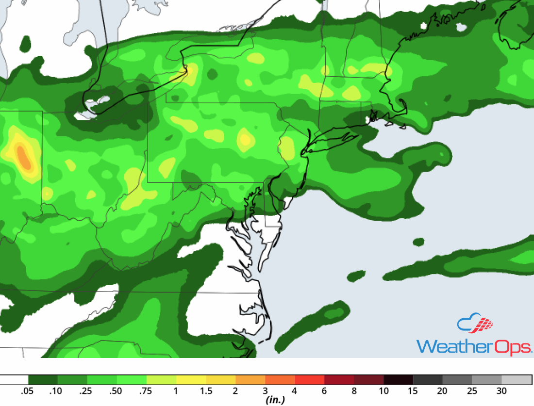 Rainfall Accumulation for Tuesday
Thunderstorms on Wednesday for the High Plains
Isolated strong to severe thunderstorms are forecast across the High Plains on Wednesday extending from North Dakota into Texas. Storm coverage will be limited, however, instability will increase during the afternoon as a result of daytime heating; this may allow for the development of thunderstorms. Strong winds, large hail, frequent lightning, and heavy rain will all be potential hazards with these storms.
Major Cities in Region: Lubbock, TX, Amarillo, TX, Guymon, OK, North Platte, NE, Pierre, SD, Bismarck, ND
 SPC Convective Outlook for Wednesday
Thunderstorm Potential for the Central Plains Thursday
Strong to severe thunderstorms may develop across portions of the Central Plains on Thursday, especially across western Nebraska. With moisture in place and daytime heating, moderate instability is expected to develop. Increasing wind shear should support the development of severe thunderstorms during the late afternoon and evening. Damaging winds and large hail will be the primary hazards with these storms.
Major Cities in Region:: Dodge City, KS, North Platte, NE, Rapid City, SD, Pierre, SD
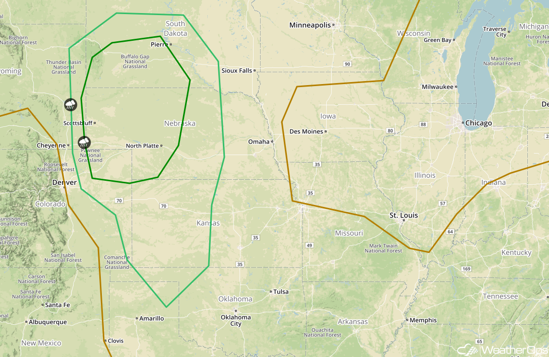 SPC Convective Outlook for Thursday
Tropical Update
A broad area of low pressure over the northeastern Gulf of Mexico is producing widespread cloudiness, showers, and thunderstorms across much of Florida, southeastern Georgia, and the Bahamas. This system has not become any better organized since yesterday and conditions are becoming less favorable for subtropical or tropical cyclone development. Heavy rainfall and possible flash flooding are expected across portions of Florida and the southeastern US over the next few days as it moves northward.
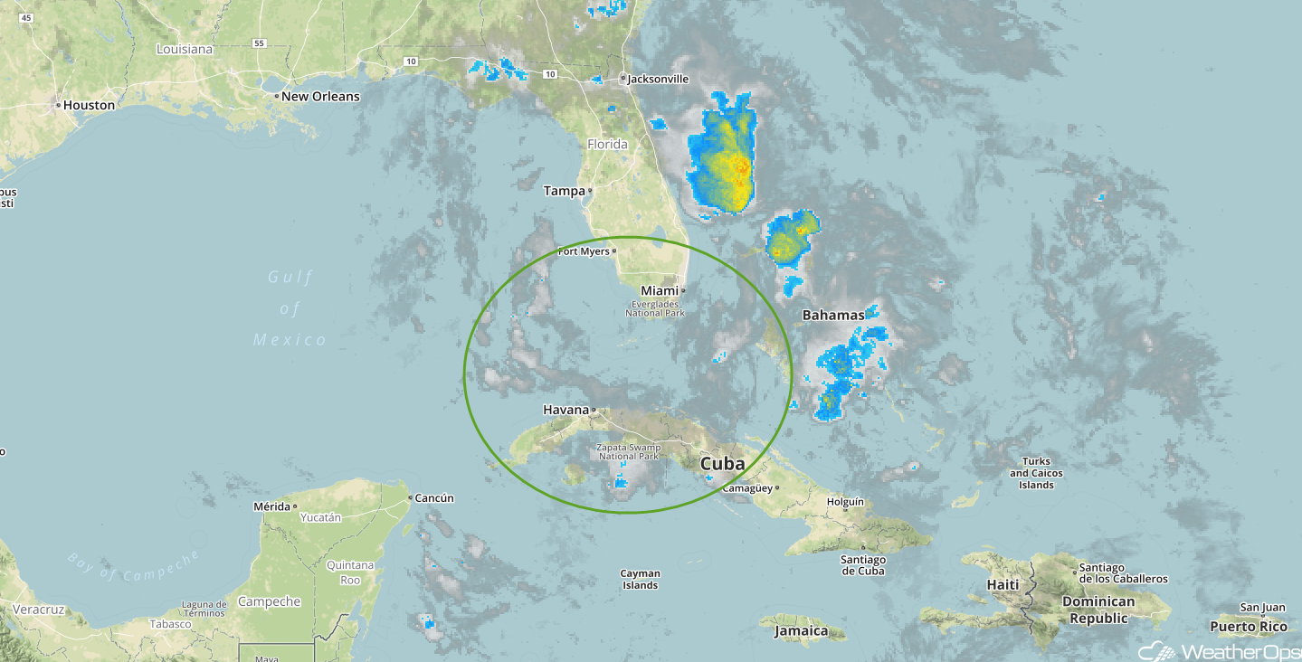 Enhanced Infrared Tropical Satellite
A Look Ahead
Showers and thunderstorms will continue across portions of the Southeast and Mid Atlantic on Friday along and ahead of a cold front. Late Friday, showers and thunderstorms are forecast across the Northern Plains as an area of low pressure develops. This activity will continue into Saturday. Thunderstorms may develop across portions of Oklahoma and North Texas on Sunday.
This is just a brief look at current weather hazards. We can provide you site-specific weather forecast information for the purpose of protecting your personnel and assets and to assess your weather risk. Try a 7-day demo right away and learn how timely precision weather information can enhance your bottom line.
