


by David Moran, on Jun 5, 2018 11:09:16 AM
A cold front moving across the Northern Plains will be the focus for thunderstorm development across the region on Tuesday. Thunderstorms may develop from western Kansas into northwestern Texas as an area of low pressure intensifies over the region. A stalled front across Eastern Texas and Southern Louisiana will continue to be the focus for thunderstorm development throughout the day.
- Thunderstorms across the Northern Plains on Tuesday
- Potential for Thunderstorms Tuesday from Western Kansas into Northwestern Texas
- Risk for Thunderstorms across Eastern Texas and Southern Louisiana on Tuesday
- Thunderstorms Wednesday across Iowa and Southern Minnesota
- Thunderstorm Potential from Montana and Wyoming into Nebraska Wednesday
- Risk for Thunderstorms Wednesday from Western Kansas to the Texas Panhandle
- Thunderstorms for the Central Plains on Thursday
- Potential for Thunderstorms Thursday across the Southern High Plains
 US Hazards

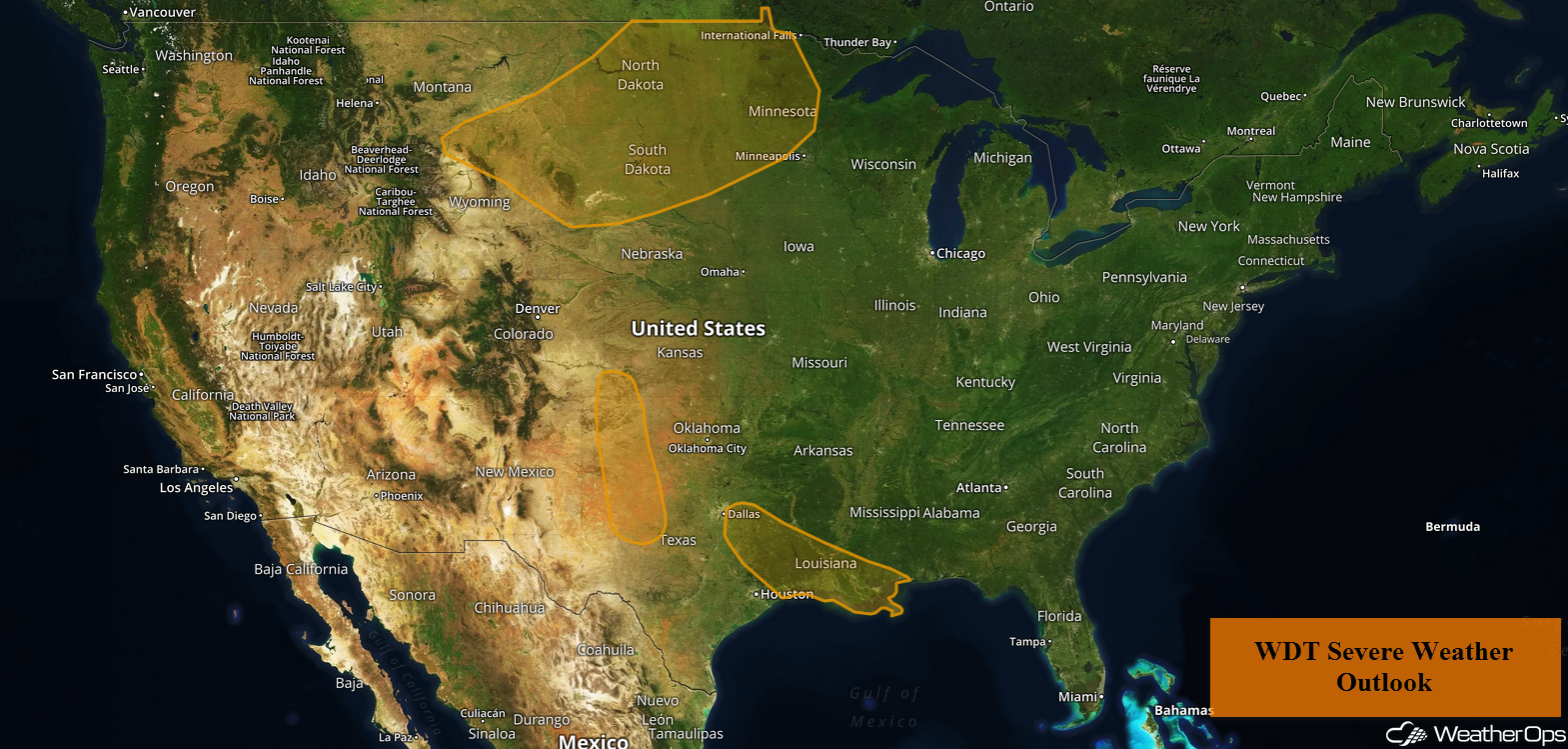
Thunderstorms across the Northern Plains on Tuesday
An area of low pressure over Saskatchewan and Montana will move eastward today. The associated cold front will move across the region. Warm moist air moving northward should allow for the development of thunderstorms along and ahead of the front. Storms could produce damaging winds and large hail, as well as a few tornadoes, especially across eastern North Dakota. These storms are expected to form a large cluster during the evening and move to the southeast. The primary hazard will be damaging winds, which could continue into the overnight hours.
Major Cities in Region: Rapid City, SD, Minot, ND, Bismarck, ND, Pierre, SD, Fargo, ND
 Thunderstorm Risk for Tuesday
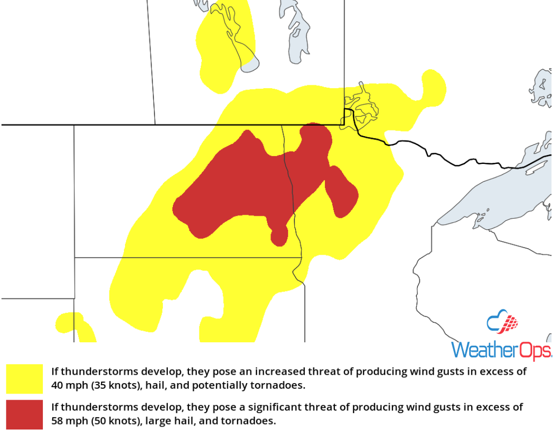
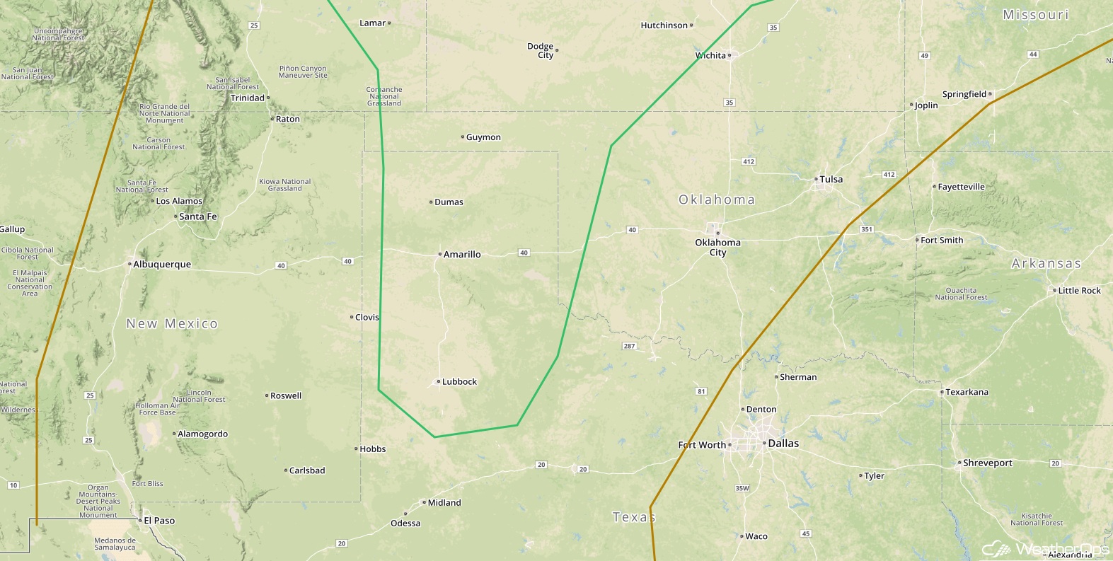
Potential for Thunderstorms Tuesday from Western Kansas into Northwestern Texas
An area of low pressure will allow moist air to move northward across the region through the day. With cooler air aloft, moderate instability is likely to build through the afternoon as daytime heating increases. Isolated strong to severe thunderstorms will develop during the afternoon with large hail and damaging winds the primary hazards. Storms should decrease in intensity after dark.
Major Cities in Region: Lubbock, TX, Amarillo, TX, Goodland, KS
 Thunderstorm Risk for Tuesday
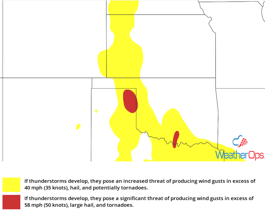
Risk for Thunderstorms across Eastern Texas and Southern Louisiana on Tuesday
Thunderstorms will continue across portions of East Texas and southern Louisiana along a stalled front. Additional storms will likely develop during the afternoon as daytime heating increases. Damaging winds will be the primary hazard with these storms.
Major Cities in Region: Tyler, TX, Beaumont, TX, Baton Rouge, LA, New Orleans, LA
 Thunderstorm Risk for Tuesday
Thunderstorms Wednesday across Iowa and Southern Minnesota
Instability will increase across the region on Wednesday as southerly winds bring warm, moist air northward. An upper level system should move over the region during the afternoon, allowing for the development of strong to severe thunderstorms. As thunderstorms initially develop, large hail and damaging winds will be possible. Later in the evening, thunderstorms may form clusters with damaging winds the primary hazard.
Major Cities in Region: Des Moines, IA, Waterloo, IA, Rochester, MN, Minneapolis, MN
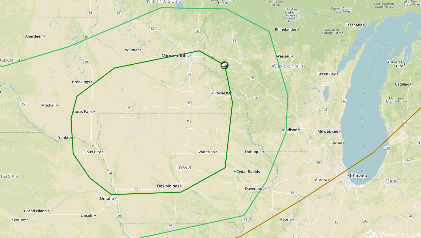 SPC Convective Outlook for Wednesday
Thunderstorm Potential from Montana and Wyoming into Nebraska Wednesday
An area of low pressure developing in the lee of the Rockies will bring warm moist air into Montana and Wyoming on Wednesday. Instability should be sufficient for the development of isolated strong to severe thunderstorms. These storms will likely move to the southeast and should continue into the evening and overnight hours as the low level jet intensifies across the region. Large hail and damaging winds will be the primary hazards with these storms.
Major Cities in Region: Billings, MT, Cheyenne, WY, North Platte, NE
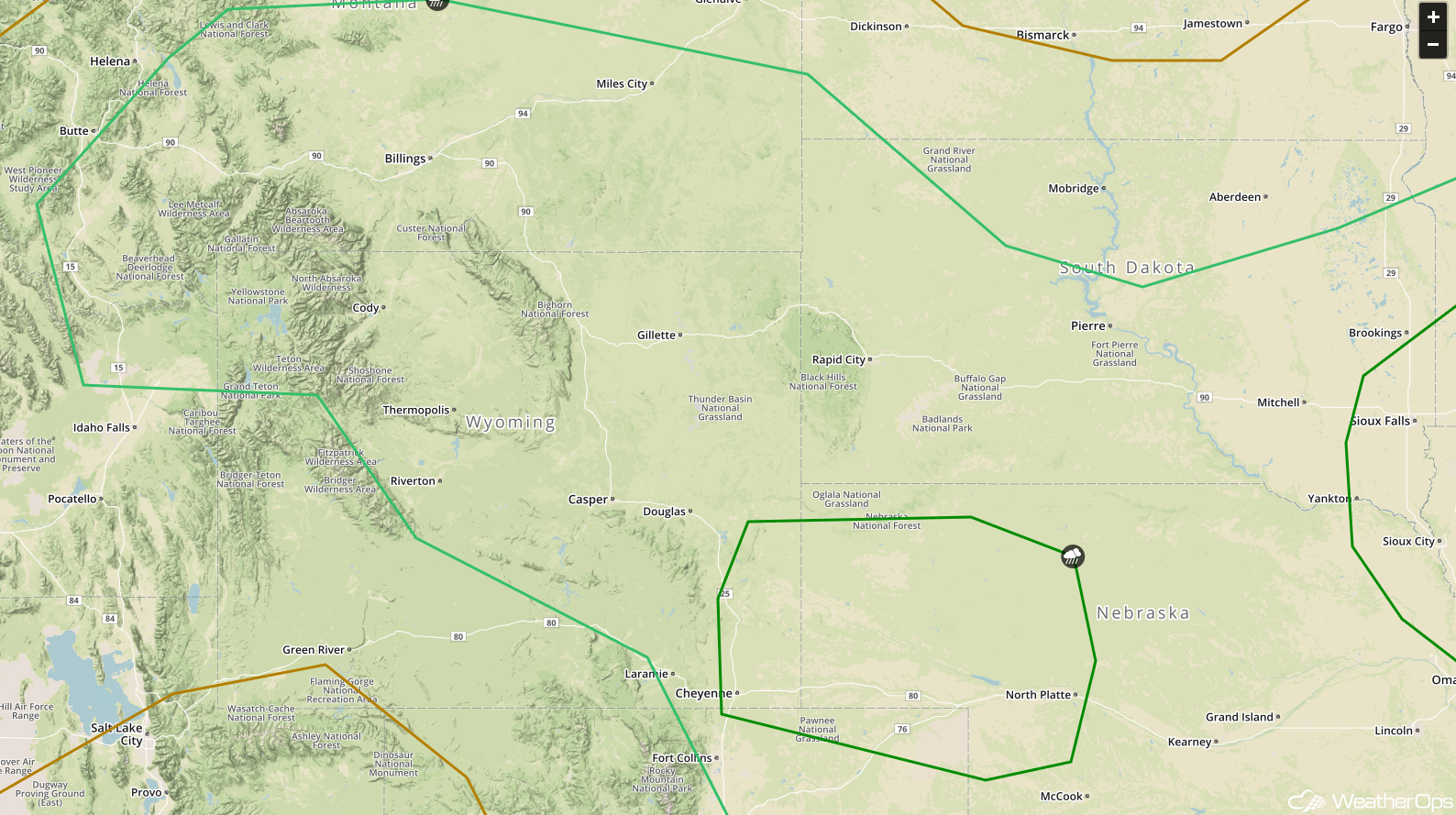 SPC Convective Outlook for Wednesday
Risk for Thunderstorms Wednesday from Western Kansas to the Texas Panhandle
The area of low pressure in the lee of the Rockies described above will bring warm moist air into the region. This will allow instability to build, creating a favorable environment for the development of isolated to widely scattered thunderstorms during the afternoon. Damaging winds will be the primary hazard with these storms, but some there may be some isolated instances of large hail.
Major Cities in Region: Lubbock, TX, Amarillo, TX, Dodge City, KS
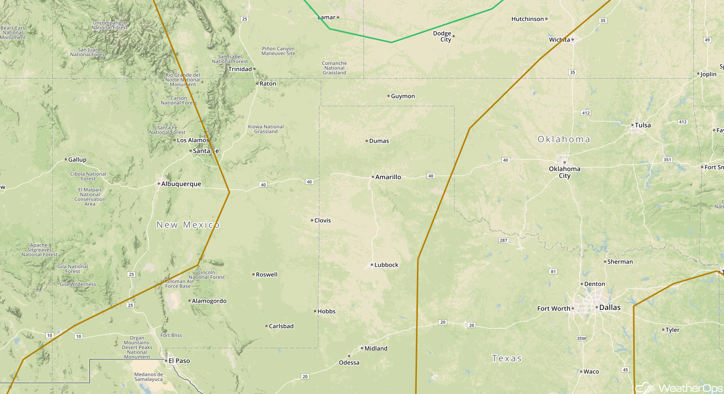 SPC Convective Outlook for Wednesday
Thunderstorms for the Central Plains on Thursday
Moisture is forecast to increase across the region on Thursday. A few weak disturbances aloft moving over the region should produce enough lift for the development of strong to severe thunderstorms. Activity will initially develop across Montana and Wyoming with large hail and damaging winds the primary hazards. As the low level jet intensifies after dark, storms may grow into clusters and move southeastward into portions of South Dakota, eastern Wyoming, and northwestern Nebraska. These storms may continue into the overnight hours and may produce damaging winds.
Major Cities in Region: Dodge City, KS, Kansas City, MO, North Platte, NE, Omaha, NE, Des Moines, IA, Sioux Falls, SD, Pierre, SD, Rapid City, SD, Bismarck, ND
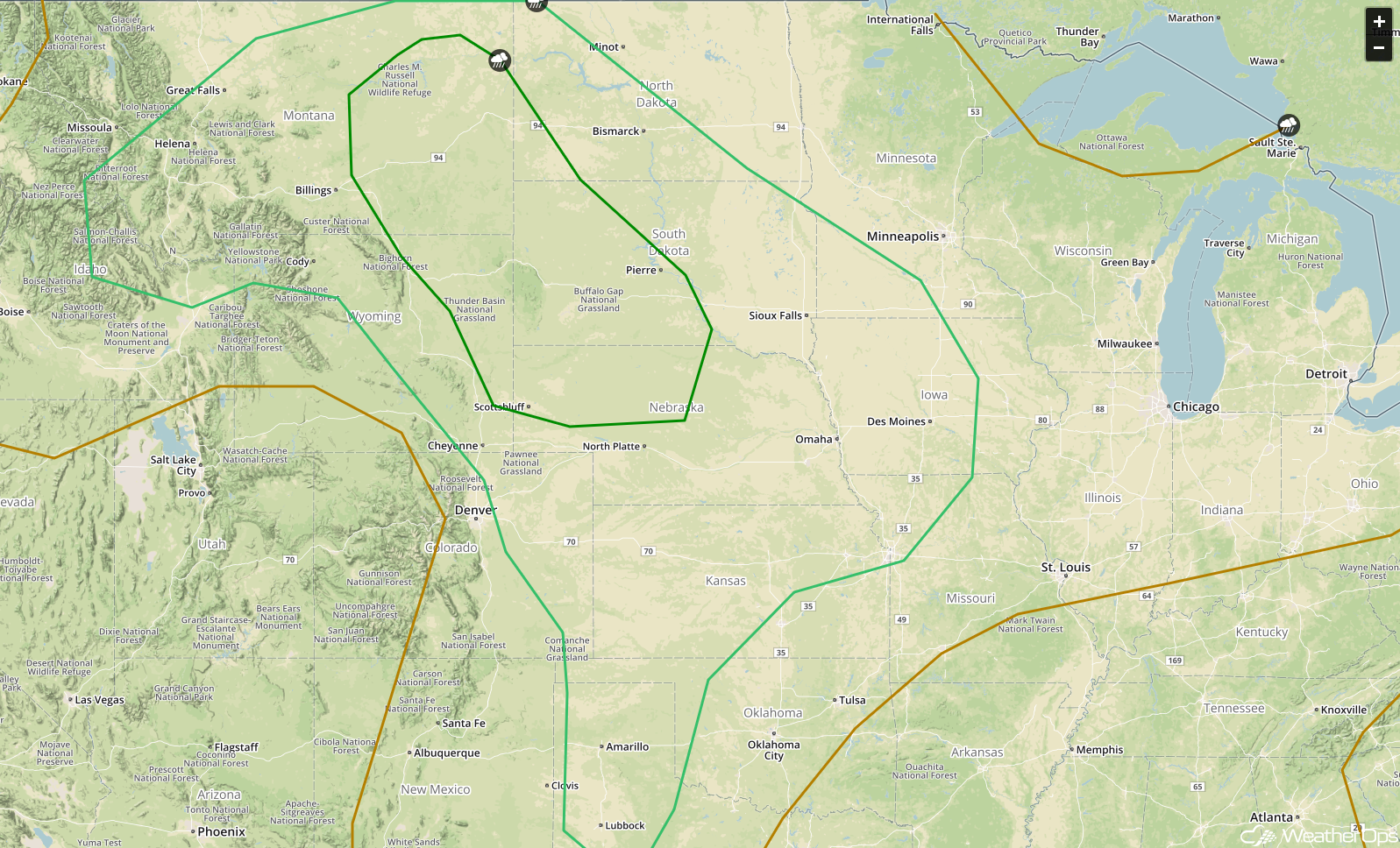 SPC Convective Outlook for Thursday
Potential for Thunderstorms Thursday across the Southern High Plains
An area of low pressure will develop in the lee of the Rockies on Thursday, bringing warm, moist air into the region. This should provide sufficient instability for the development of thunderstorms during the afternoon. Some of these storms will be capable of producing large hail and damaging winds. Activity should dissipate after dark with the loss of daytime heating.
Major Cities in Region: Lubbock, TX, Amarillo, TX, Guymon, OK
 SPC Convective Outlook for Thursday
A Look Ahead
Showers and thunderstorms may develop across portions of the Northern Plains and Upper Midwest on Friday as an area of low pressure moves through the region. By early Saturday, showers will extend from the Missouri Valley into the Great Lakes. This activity will move into the Mid Atlantic on Sunday.
This is just a brief look at current weather hazards. We can provide you site-specific weather forecast information for the purpose of protecting your personnel and assets and to assess your weather risk. Try a 7-day demo right away and learn how timely precision weather information can enhance your bottom line.
