


by David Moran, on Jun 26, 2018 11:17:12 AM
A stalled front will be the focus for the development of thunderstorms across the Missouri and Mississippi Valleys on Tuesday. Multiple rounds of showers and thunderstorms will allow for a risk of excessive rainfall across the Ozarks, Tennessee Valley, and Southern Great Lakes. A stalled front along the Appalachians will be the focus for the development of thunderstorms from the Appalachians into North Georgia and the Carolinas. Thunderstorms across eastern North Carolina will bring a risk for excessive rainfall. As an area of low pressure lifts northward into Canada, thunderstorms may develop across the Northern Plains ahead of the associated cold front.
- Thunderstorms for the Missouri and Mississippi Valleys on Tuesday
- Excessive Rainfall Tuesday for the Ozarks, Tennessee Valley, and Southern Great Lakes
- Thunderstorm Potential Tuesday from the Appalachians into the Carolinas and Georgia
- Risk for Excessive Rainfall across Eastern North Carolina Tuesday
- Thunderstorms Tuesday across the Northern Plains
- Potential for Thunderstorms from East Indiana into Western Pennsylvania and West Virginia Wednesday
- Excessive Rainfall Wednesday from East Indiana into Western Pennsylvania and West Virginia
- Thunderstorm Potential across the Dakotas and Northern Minnesota Thursday
- Tropical Update
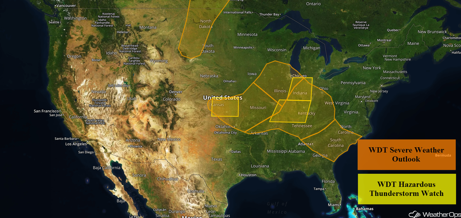 US Hazards

Thunderstorms for the Missouri and Mississippi Valleys on Tuesday
Warm, moist, and unstable air will be located to the south of a stalled front located from eastern Kentucky northwestward into Iowa. Moderate westerly winds in the mid-levels of the atmosphere will provide adequate wind shear for organized storm development. While there is some uncertainty in the forecast, any thunderstorms that develop will pose a risk for large hail and damaging winds. A brief tornado cannot be ruled out.
Major Cities in Region: Kansas City, MO, Columbia, MO, St. Louis, MO
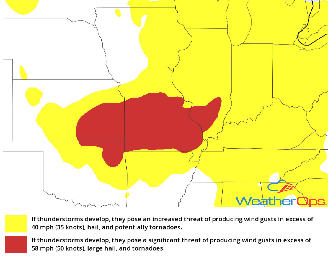 Thunderstorm Risk for Tuesday
Excessive Rainfall Tuesday for the Ozarks, Tennessee Valley, and Southern Great Lakes
In addition to the thunderstorms described above, there will be the potential for heavy to excessive rainfall. Multiple rounds of showers and thunderstorms are expected throughout the day across the region. Rainfall totals will range 1-2 inches with locally higher amounts in excess of 3 inches.
Major Cities in Region: Springfield, MO, St. Louis, MO, Springfield, IL, Milwaukee, WI, Chicago, IL
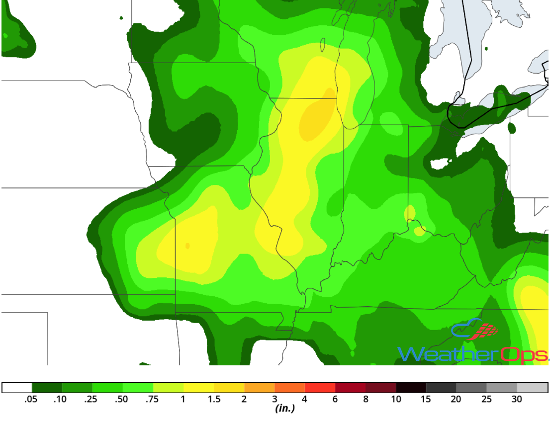 Rainfall Accumulation for Tuesday
Thunderstorm Potential Tuesday from the Appalachians into the Carolinas and Georgia
Daytime heating with abundant low level moisture will allow for the development of thunderstorms during the afternoon and early evening along a stalled front. Thunderstorms will initially develop across the Appalachians and track southeastward. Damaging winds will be the primary hazard with these storms.
Major Cities in Region: Asheville, NC, Greenville, SC
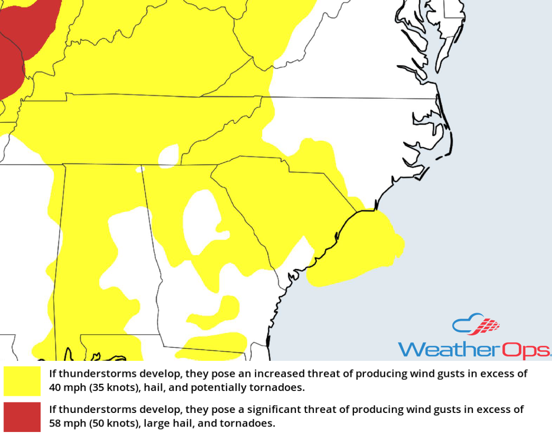 Thunderstorm Risk for Tuesday
Risk for Excessive Rainfall across Eastern North Carolina Tuesday
Scattered showers and thunderstorms are expected to develop along a stalled front as a series of mid-level disturbances move across the region. Rainfall totals will range 1-2 inches with locally higher amounts in excess of 3 inches.
Major Cities in Region: Raleigh, NC, Wilmington, NC
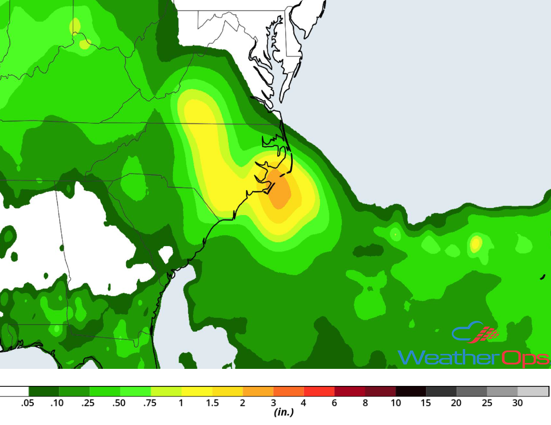 Rainfall Accumulation for Tuesday
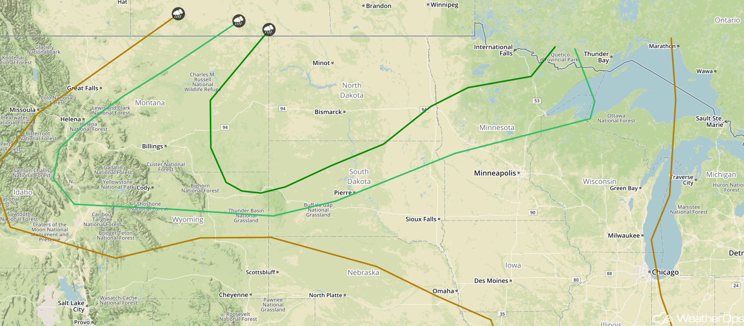
Thunderstorms Tuesday across the Northern Plains
A few isolated thunderstorms may develop during the late afternoon and evening as an area of low pressure lifts northward into Canada. Any storms that develop will have the potential to produce large hail and damaging winds.
Major Cities in Region: Minot, ND, Bismarck, ND, Pierre, SD
 Thunderstorm Risk for Tuesday
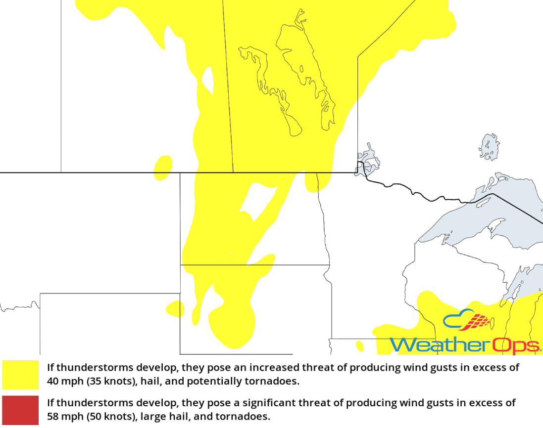
Potential for Thunderstorms from East Indiana into Western Pennsylvania and West Virginia Wednesday
A cold front is expected to move slowly across the region during the day on Wednesday. Morning showers and cloud cover may inhibit instability from building along and ahead of the front by the afternoon. If thunderstorms develop, damaging winds and hail will be the primary hazards.
Major Cities in Region: Louisville, KY, Cincinnati, OH, Toledo, OH, Columbus, OH, Cleveland, OH, Charleston, WV, Pittsburgh, PA
 SPC Convective Outlook for Wednesday
Excessive Rainfall Wednesday from East Indiana into Western Pennsylvania and West Virginia
In addition to the thunderstorms described above, there will be a risk for excessive rainfall. Most areas will receive less than an inch, but some of the heavier storms may produce rainfall rates in excess of 1.00-1.50 inches per hour. Rainfall totals could range 2-3 inches.
Major Cities in Region: Cincinnati, OH, Columbus, OH, Charleston, WV, Cleveland, OH, Pittsburgh, PA
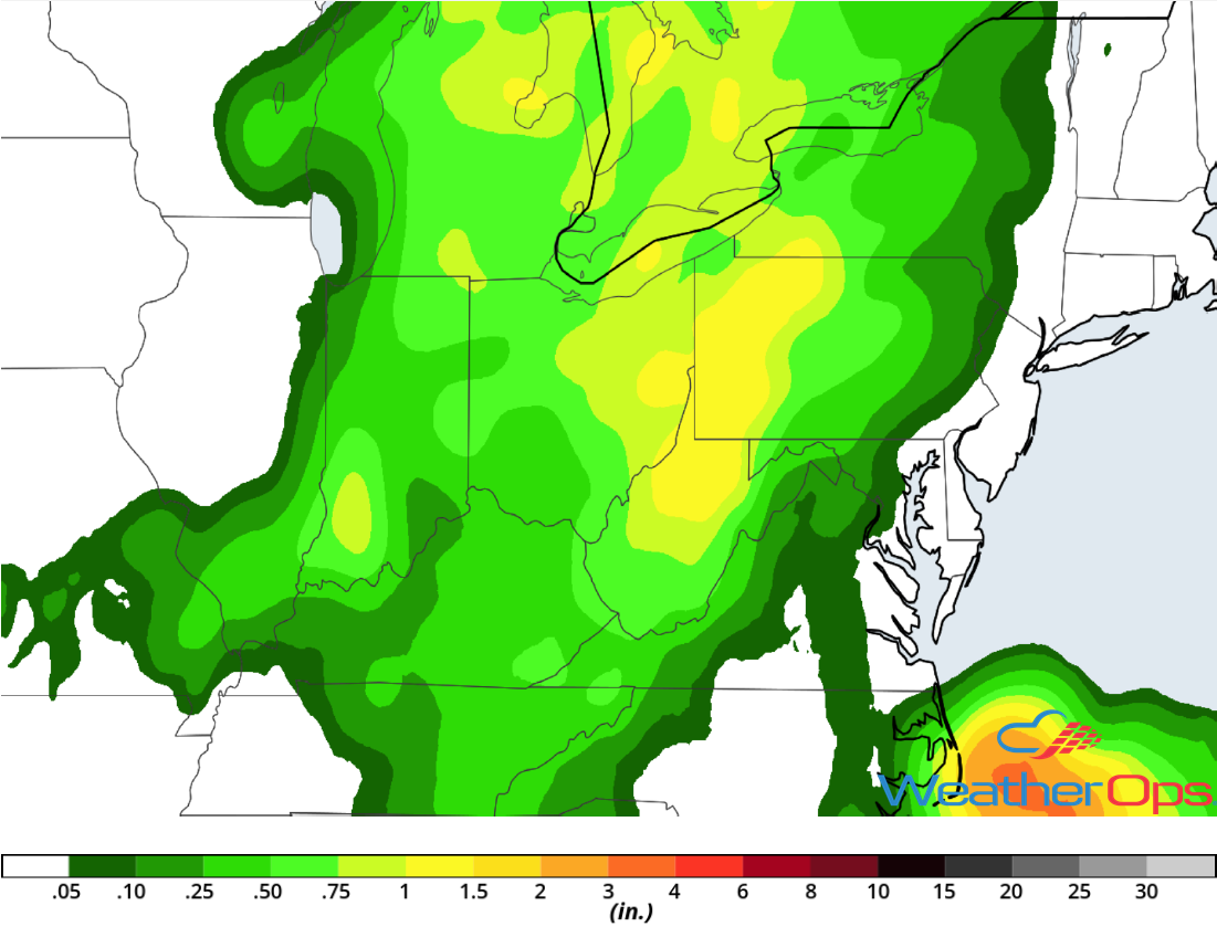 Rainfall Accumulation for Wednesday
Thunderstorm Potential across the Dakotas and Northern Minnesota Thursday
A strong area of low pressure is forecast to develop across the Northern Plains on Thursday. Warm surface temperatures, plentiful moisture, and cooling temperatures in the mid-levels will allow strong instability to build. Moderate wind shear will allow any thunderstorms that develop to become severe quickly. Large hail, damaging winds, and tornadoes will all be potential hazards with any storms that develop.
Major Cities in Region: Billings, MT, Minot, ND, Bismarck, ND, Pierre, SD, International Falls, MN
 SPC Convective Outlook for Thursday
Tropical Update
A non-tropical area of low pressure will likely develop along a stalled front near the coast of North Carolina on Wednesday. This system may become tropical over the next few days as it moves eastward or northeastward.
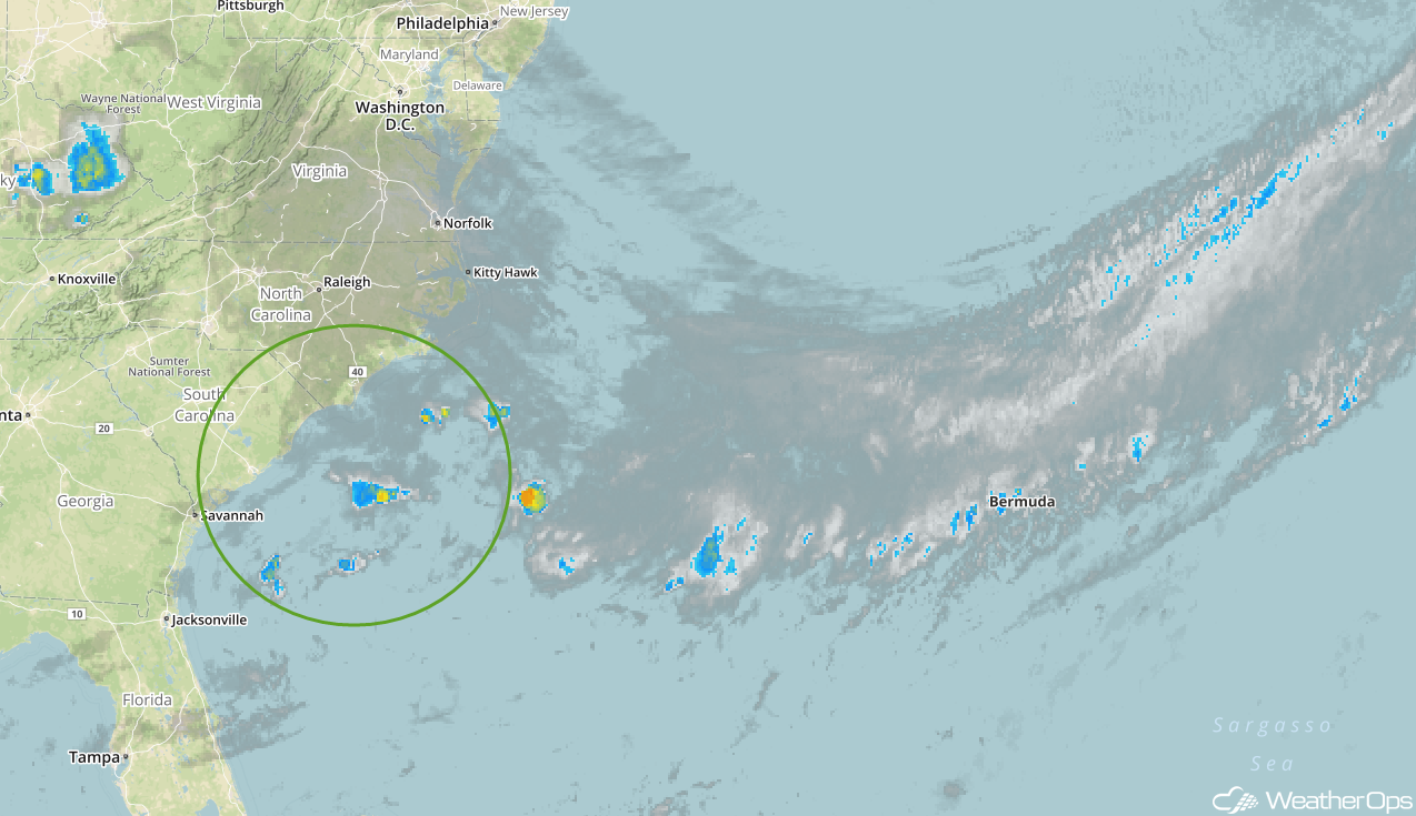 Enhanced Infrared Satellite
A Look Ahead
Showers and thunderstorms will continue across the Northern Plains and Upper Midwest on Friday as an area of low pressure continues to move eastward. Additional activity may develop over the same area on Saturday ahead of a cold front. On Sunday, showers and thunderstorms will extend from the Great Lakes into the Plains. Another round of showers and thunderstorms may develop across the Northern Plains and Upper Midwest early next week.
This is just a brief look at current weather hazards. We can provide you site-specific weather forecast information for the purpose of protecting your personnel and assets and to assess your weather risk. Try a 7-day demo right away and learn how timely precision weather information can enhance your bottom line.
