


by David Moran, on Jun 19, 2018 12:02:04 PM
The risk for excessive rainfall will continue across portions of Texas through Thursday as an area of low pressure continues to stall across southeast Texas. Elevated winds and seas, as well as thunderstorms, will continue for portions of the Gulf of Mexico through Thursday morning. Thunderstorms may develop across portions of the Plains on Tuesday as an area of low pressure moves across the region. A stalled front will be the focus for thunderstorm development from the Midwest into the Mid Atlantic. Thunderstorms extending from the Plains into the Mid Atlantic will bring a risk for excessive rainfall through Wednesday.
- Excessive Rainfall Continuing across Texas through Thursday
- Elevated Conditions through Thursday Morning for Portions of the Gulf of Mexico
- Thunderstorms for the Plains on Tuesday
- Potential for Thunderstorms Tuesday from the Midwest to the Mid Atlantic
- Risk for Excessive Rainfall from the Plains into the Mid Atlantic through Wednesday
- Thunderstorms Wednesday for the Central and Southern Plains
- Thunderstorm Potential for the Mid Atlantic on Wednesday
- Risk for Thunderstorms Wednesday across Central Oregon
- Thunderstorms for the Southern High Plains on Thursday
- Potential For Thunderstorms Thursday across Central Montana
- Risk for Excessive Rainfall from the Midwest into the Mid Atlantic on Thursday
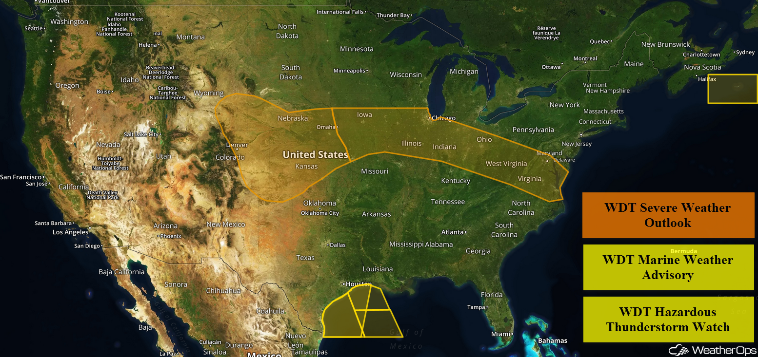 US Hazards

Excessive Rainfall Continuing across Texas through Thursday
An area of low pressure is currently stalled across southeastern Texas and will remain in place for the next several days. This will allow for a long, sustained period of rainfall through at least Thursday, with activity decreasing through the end of the week and into the weekend. Current rainfall estimates range 2-5 inches with locally higher amounts in excess of 10 inches, particularly around the Corpus Christi area. Significant flooding is likely and flash flooding is expected.
Major Cities in Region: Brownsville, TX, Corpus Christi, TX, Houston, TX
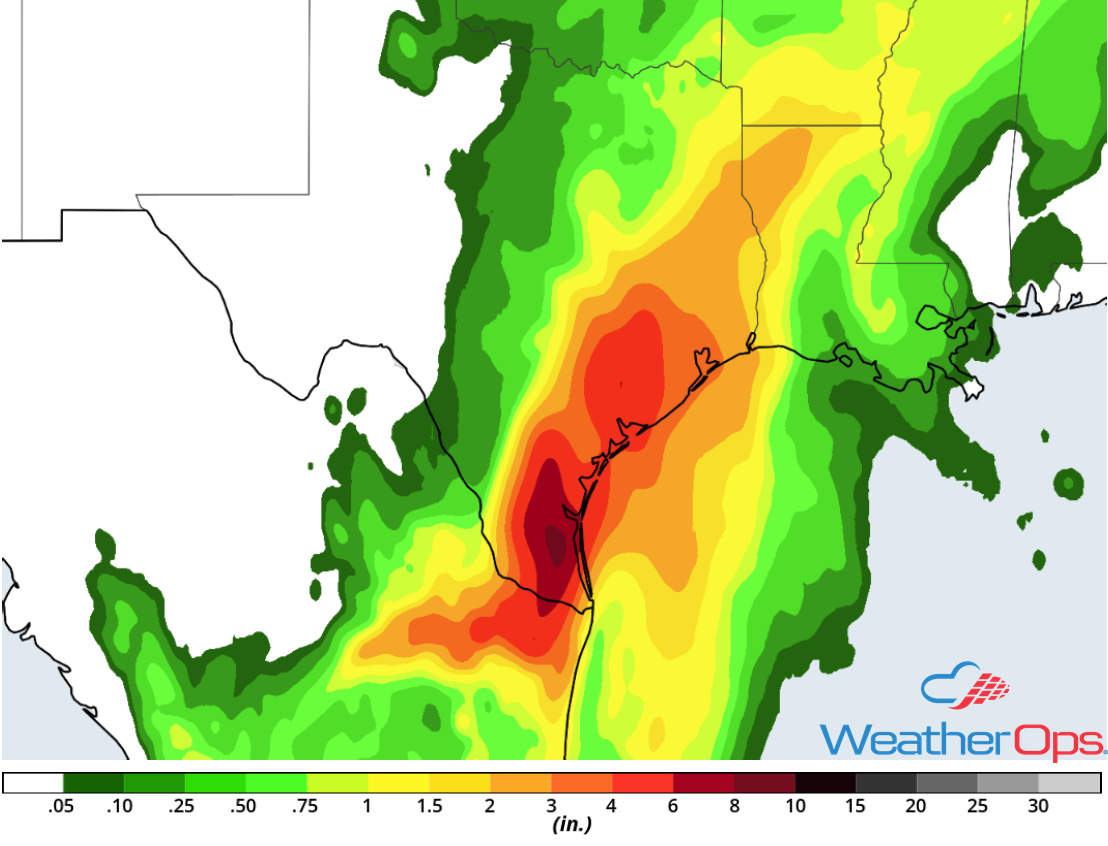 Rainfall Accumulation through Thursday
Elevated Conditions through Thursday Morning for Portions of the Gulf of Mexico
Elevated winds and seas will continue across the western Gulf of Mexico through Thursday morning as a result of the area of low pressure described above. Across the western portions of the region, winds will range 20-30 knots with gusts in excess of 35 knots. Seas near the shore will range 5-7 feet and 6-8 feet in the deeper waters. For eastern portions of the region, seas will range 7-10 feet. In addition, thunderstorms will continue across the region. Winds in excess of 50 knots, waterspouts, heavy rain, and frequent lightning will be potential hazards with these storms.
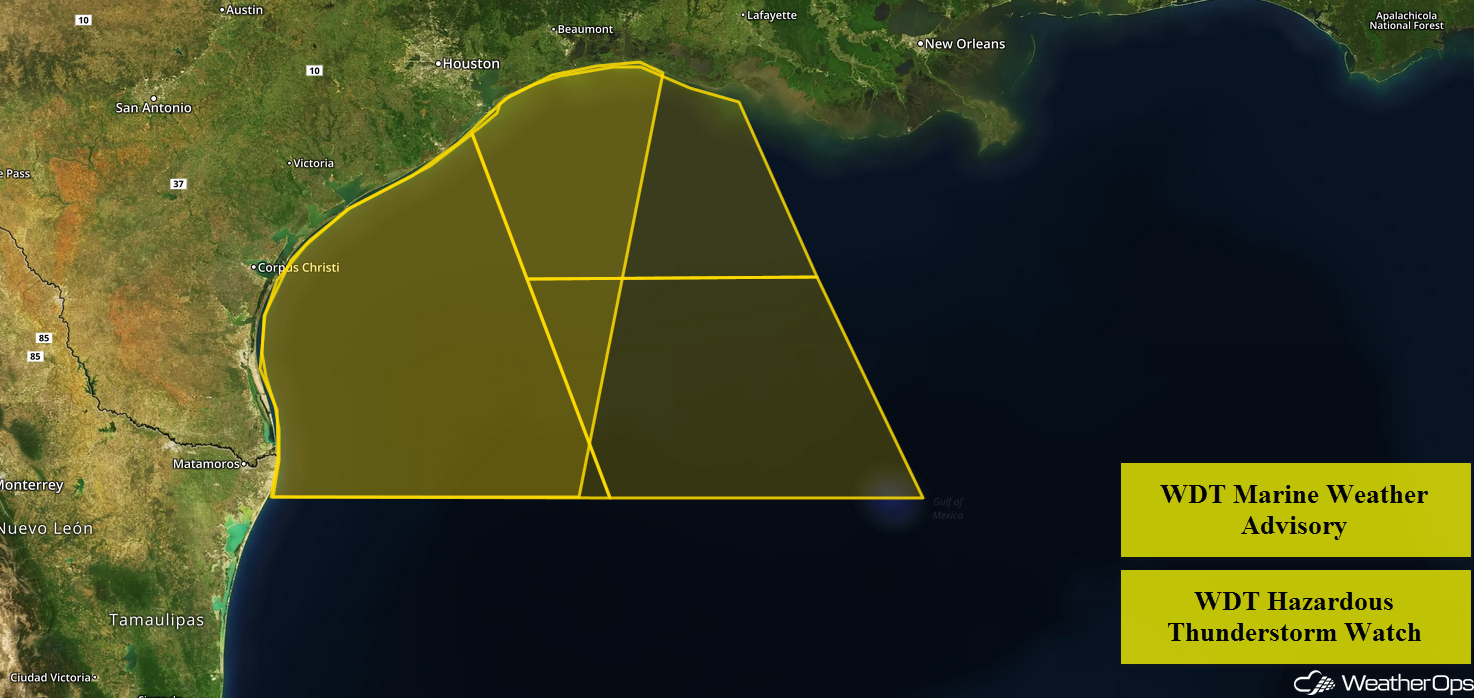 WDT Marine Weather Advisory and Hazardous Thunderstorm Watch
Thunderstorms for the Plains on Tuesday
An area of low pressure, plentiful moisture, and daytime heating will allow for the development of strong to severe thunderstorms across portions of the Plains. As thunderstorms develop, they will be isolated with large hail, damaging winds, and tornadoes all potential hazards. These storms will eventually congeal into clusters and move eastward during the evening and overnight hours. Damaging winds and hail will then become the primary hazards with these storms.
Major Cities in Region: Goodland, KS, Dodge City, KS, Lincoln, NE, Omaha, ME
 Thunderstorm Risk for Tuesday
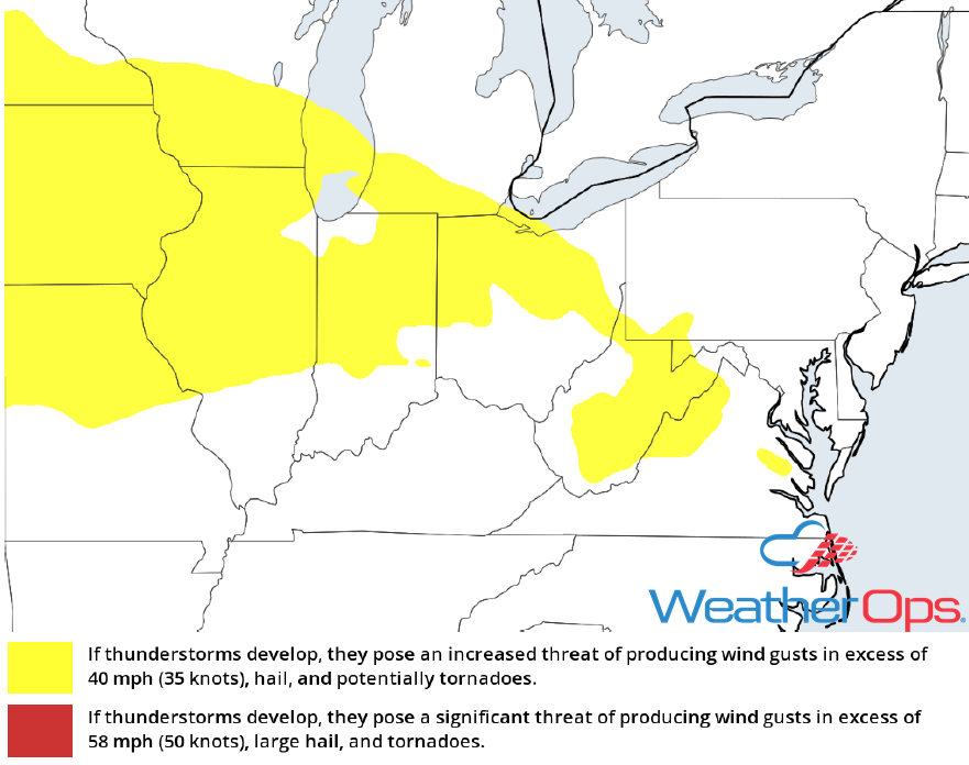
Potential for Thunderstorms Tuesday from the Midwest to the Mid Atlantic
A stalled front will be the main focus for the development of thunderstorms from the Midwest into the Mid Atlantic. Strong daytime heating and abundant moisture will allow instability to build during the afternoon. Damaging winds will be the primary hazard with the stronger storms.
Major Cities in Region: Springfield, IL, Indianapolis, IN, Toledo, OH, Charleston, WV, Washington, DC, Norfolk. VA
 Thunderstorm Risk for Tuesday
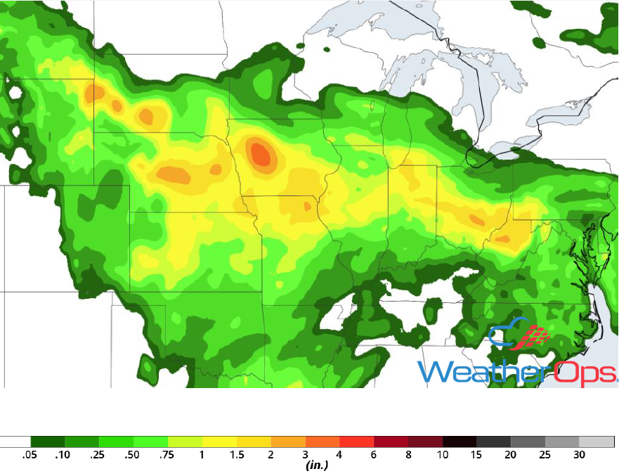
Risk for Excessive Rainfall from the Plains into the Mid Atlantic through Wednesday
With plentiful moisture along the stalled front described above, widespread showers and thunderstorms are expected. Rainfall totals will range 1-2 inches with locally higher amounts in excess of 3 inches, particularly across the Central Plains and Midwest. This will allow for a flooding risk. Further east across the Mid Atlantic, two day rainfall totals may exceed 2 inches.
Major Cities in Region: North Platte, NE, Sioux City, IA, Des Moines, IA, Indianapolis, IN, Charleston, WV
 Rainfall Accumulation for Tuesday and Wednesday
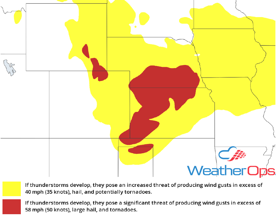
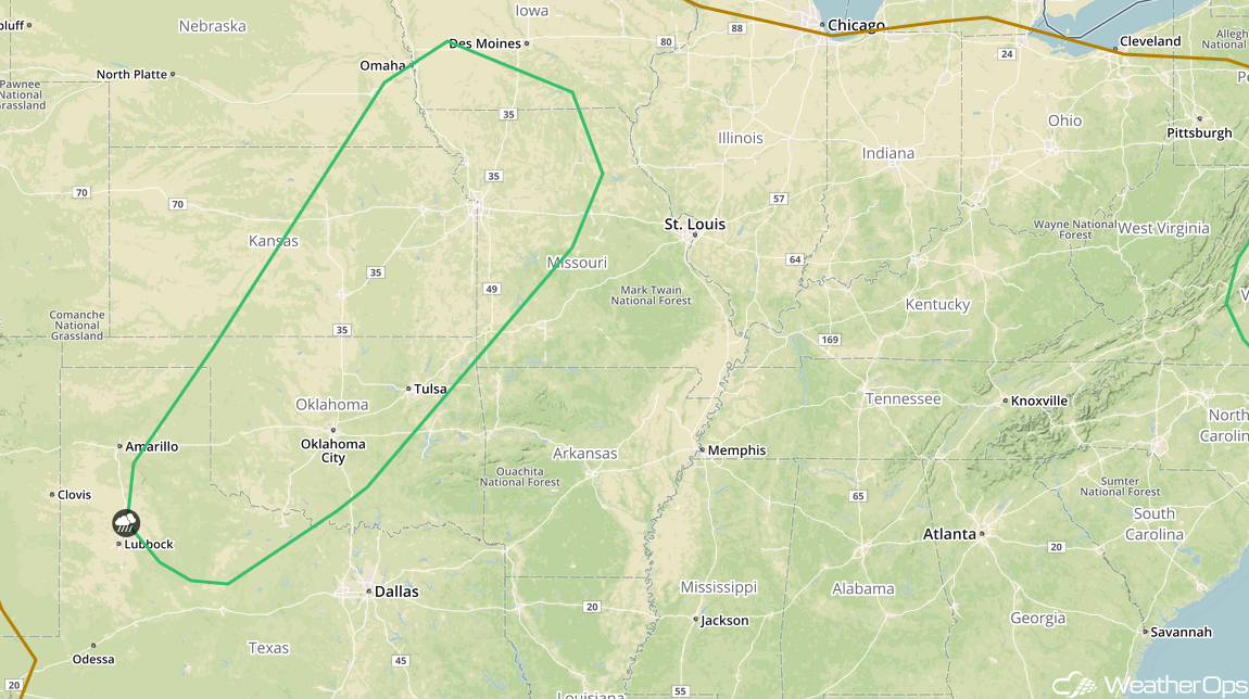
Thunderstorms Wednesday for the Central and Southern Plains
Thunderstorms will likely be ongoing during the morning on Wednesday. However, remnant outflow boundaries and a cold front will allow for the development of additional thunderstorms during the afternoon. Large hail and damaging winds will be the primary hazards with these storms.
Major Cities in Region: Lawton, OK, Oklahoma City, OK, Wichita, KS, Tulsa, OK, Topeka, KS, Omaha, NE, Kansas City, MO
 SPC Convective Outlook for Wednesday
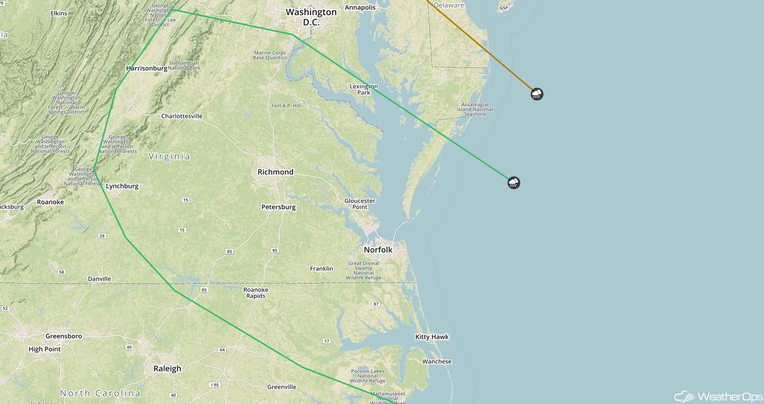
Thunderstorm Potential for the Mid Atlantic on Wednesday
An area of low pressure is expected to intensify across the region on Wednesday, promoting the development of isolated to widely scattered thunderstorms during the afternoon. With any of the stronger storms, damaging winds and large hail will be the primary hazards.
Major Cities in Region: Lynchburg, VA, Richmond, VA, Norfolk, VA
 SPC Convective Outlook for Wednesday
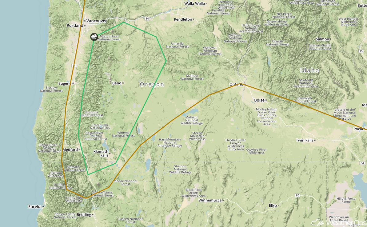
Risk for Thunderstorms Wednesday across Central Oregon
Strong surface heating and cooler temperatures aloft will allow instability to build across central Oregon on Wednesday. Westerly winds will likely promote upslope flow, leading to the development of scattered thunderstorms by the afternoon. Strong winds and hail will be the primary hazards with these storms.
Major Cities in Region: Medford, OR, Klamath Falls, OR, Bend, OR
 SPC Convective Outlook for Wednesday
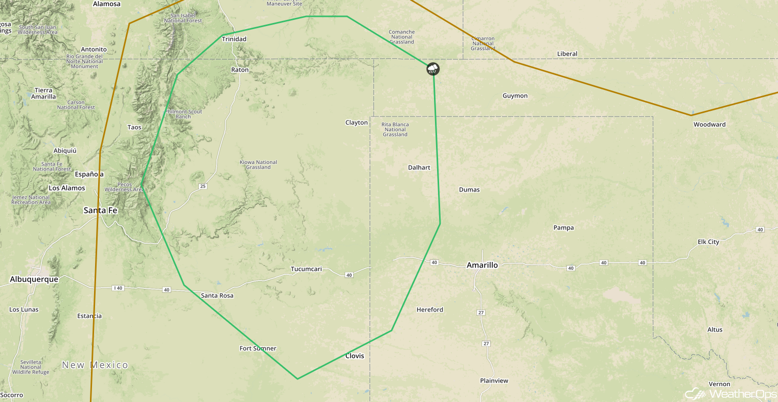
Thunderstorms for the Southern High Plains on Thursday
Strong daytime heating, moisture, and southerly flow will allow for the potential for thunderstorm development across northeastern New Mexico Thursday afternoon. Any thunderstorms that develop are forecast to move into the Texas and Oklahoma Panhandles. Strong to damaging winds and large hail will be the primary hazards.
Major Cities in Region: Tucumcari, NM, Clovis, NM
 SPC Convective Outlook for Thursday
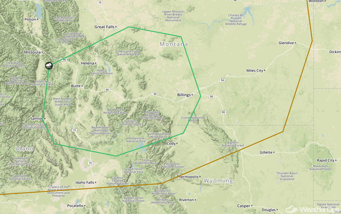
Potential For Thunderstorms Thursday across Central Montana
An area of low pressure moving across the region will promote the development of strong to severe thunderstorms along and ahead of a cold front. Cooling temperatures aloft will increase instability. With strong shear in place, storms may produce strong winds and large hail.
Major Cities in Region: Butte, MT, Helena, MT, Billings, MT
 SPC Convective Outlook for Thursday
Risk for Excessive Rainfall from the Midwest into the Mid Atlantic on Thursday
An area of low pressure lifting northeastward through the central US will bring another round of rainfall to portions of the Midwest and Mid-Atlantic on Thursday. Rainfall totals will range 0.50-1.50 inches with locally higher amounts in excess of 2 inches. Due to moist soil from previous days' rainfall, there will be a risk for flooding and flash flooding across these areas.
Major Cities in Region: Des Moines, IA, Cedar Rapids, IA, Springfield, IL, Indianapolis, IN, Charleston, WV, Richmond, VA, Norfolk, VA
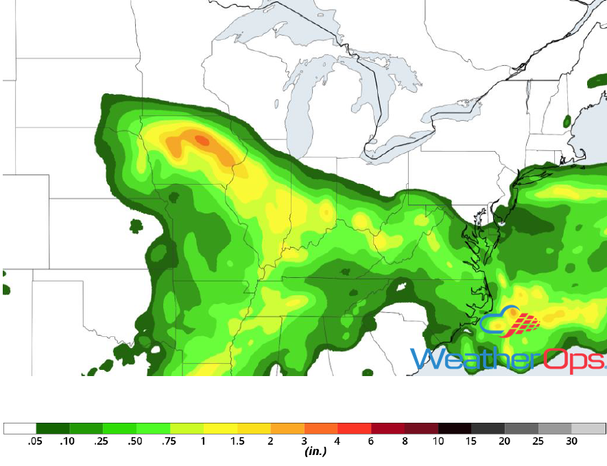 Rainfall Accumulation for Thursday
A Look Ahead
Showers and thunderstorms will continue across the Mid Mississippi and Ohio Valleys on Friday as an area of low pressure continues to move eastward. By late Friday or early Saturday, showers and thunderstorms will move into the Great Lakes. During the day on Saturday, the activity across the Great Lakes will progress eastward into the Northeast. Elsewhere, thunderstorms may develop across portions of the Plains during the afternoon and evening hours. This activity will move into the Mid Mississippi and Tennessee Valleys on Sunday. Another round of showers and thunderstorms may develop Monday across the Central and Southern Plains.
This is just a brief look at current weather hazards. We can provide you site-specific weather forecast information for the purpose of protecting your personnel and assets and to assess your weather risk. Try a 7-day demo right away and learn how timely precision weather information can enhance your bottom line.
