


by David Moran, on Jul 5, 2016 11:23:33 AM
No WeatherOps Hazards are currently in effect. An area of low pressure and associated warm front across the Central Plains will lift northeastward into the Upper Midwest, allowing for the potential for strong to severe thunderstorms on Tuesday. Further east, showers and thunderstorms will be possible from the Mid Mississippi Valley into the Mid Atlantic along a stationary front. As the area of low pressure continues to move eastward on Wednesday, strong to severe thunderstorms will be possible for the Central and Northern Plains into the Midwest. A second area of low pressure will bring a chance of thunderstorms across portions of the Central Plains and Midwest on Thursday.

US Hazards
Strong to Severe Thunderstorms Possible Tuesday for the Upper Midwest and Central Plains
An area of low pressure, and the associated warm front across the Central Plains, will lift northeastward into the Upper Midwest bringing an increased threat for thunderstorms in the afternoon. As this system lifts to the northeast, a strongly unstable atmosphere combined with ample moisture and strong wind shear is forecast to lead to the development of strong to severe thunderstorms during the afternoon and early evening hours. The primary hazards with any thunderstorms that develop will be large hail, damaging winds, and a few tornadoes, especially across portions of eastern South Dakota into Western Wisconsin, just to the south of this low pressure system and along its associated warm front.
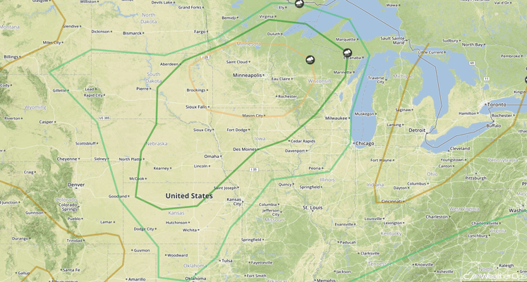
SPC Convective Outlook for Tuesday
Strong to Severe Thunderstorms Possible Tuesday from Mid Mississippi Valley to Mid Atlantic
Showers and thunderstorms are expected to develop, across portions of the Mid Mississippi Valley eastward into the Mid Atlantic, as a stationary front remains draped across the region. With ample moisture, as well as low to moderate shear and instability, some strong to severe thunderstorms will be possible during the afternoon hours. The primary hazards with any thunderstorms that develop will be strong winds and hail.

SPC Convective Outlook for Tuesday
Strong to Severe Thunderstorms Possible for Portions of the Central and Northern Plains, Midwest on Wednesday
As the area of low pressure, described above, continues to move eastward and northeastward across the Great Lakes and into Ontario early on Wednesday, the associated cold front will stall out across the Central and High Plains. As early morning thunderstorm activity across portions of eastern Wyoming and southeastern Montana moves southeastward, an unstable and moist atmosphere is forecast to maintain any early morning thunderstorm activity. Later in the afternoon, isolated to scattered thunderstorms will be possible just to the south of a stalled front. The primary threats within any thunderstorm that develops will be hail and strong winds.

SPC Convective Outlook for Wednesday
Strong to Severe Thunderstorms Possible Thursday Across the Central Plains and Midwest
An area of low pressure is expected to develop across the High Plains on Wednesday and move eastward towards the Great Lakes. Ample moisture, as well as moderate to strong instability and wind shear, is forecast to develop across the region on Thursday. This unstable atmosphere is expected to aid in the development of strong to severe thunderstorms during the afternoon, as a shortwave trough moves through the threat region. Possible hazards within any thunderstorm that develops will be very large hail and damaging winds.

SPC Convective Outlook for Thursday
This is just a brief look at current weather hazards. We can provide you site-specific forecast information. Try a 7-day demo right away.

