National Weather Summary for Tuesday, July 25, 2017
by David Moran, on Jul 25, 2017 10:57:19 AM
Thunderstorms and excessive rainfall may develop on Tuesday across the North Central US ahead of an area of low pressure and cold front. The risk for excessive rainfall will continue for the Southwest into the Great Basin.
- Thunderstorms Tuesday for the Northern and Central Plains
- Risk for Thunderstorms for the Desert Southwest and Great Basin on Tuesday
- Excessive Rainfall Continues Tuesday from the Southwest into the Great Basin
- Potential for Thunderstorms from the Midwest through the Great Lakes on Wednesday
- Thunderstorm Risk Wednesday for the Intermountain West
- Excessive Rainfall for Portions of Colorado and New Mexico on Wednesday
- Strong to Severe Thunderstorms Thursday from the Mississippi Valley through the Mid Atlantic and Northeast
- Thunderstorms for the Northern Rockies on Thursday
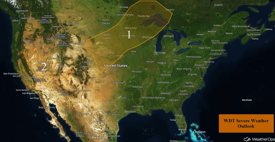 US Hazards
Thunderstorms Tuesday for the Northern and Central Plains
Strong to severe thunderstorms are forecast today across the North Central US along and ahead of a cold front and area of low pressure moving across the region. Conditions will be favorable for large hail and damaging winds with these storms, but an isolated tornado or two cannot be ruled out. The primary threat will exist during the evening and stretch from eastern portions of South Dakota, northeastward, into portions of central and south-central Minnesota and northern Wisconsin. Elsewhere, the threat for severe impacts will be less, but there will still be a risk for severe wind and hail.
Major Cities in Region: North Platte, NE, Pierre, SD, Sioux Falls, SD, Minneapolis, MN
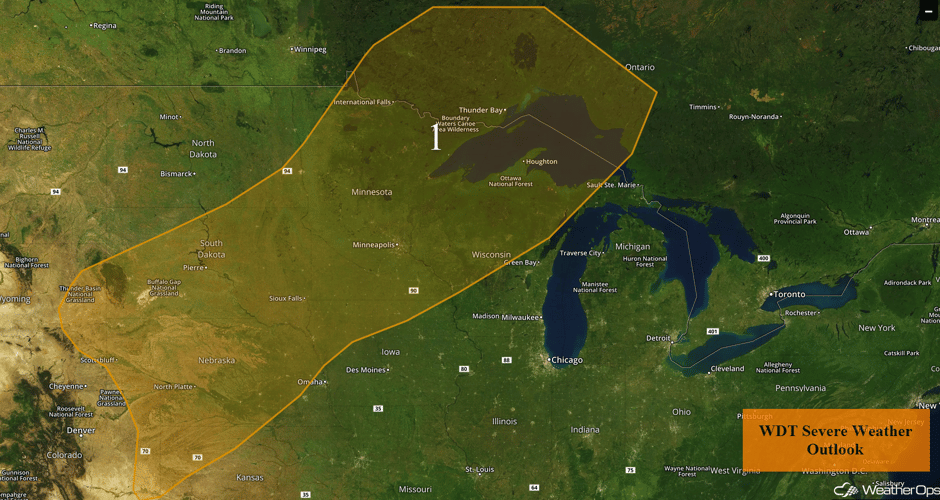 Region 1
Risk for Thunderstorms for the Desert Southwest and Great Basin on Tuesday
Isolated to scattered showers and thunderstorms are forecast across the Great Basin as well as portions of the Desert Southwest. Modest instability and sufficient moisture may allow for a few storms to become marginally severe with a low threat of severe wind gusts. Activity should weaken by dark.
Update 11:35am PDT: Thunderstorms developing across western Nevada. Damaging winds will be the primary hazard with these storms.
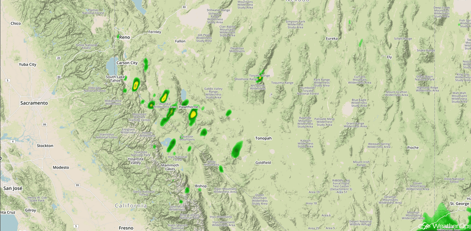 Radar 11:35am PDT
Major Cities in Region: Las Vegas, NV
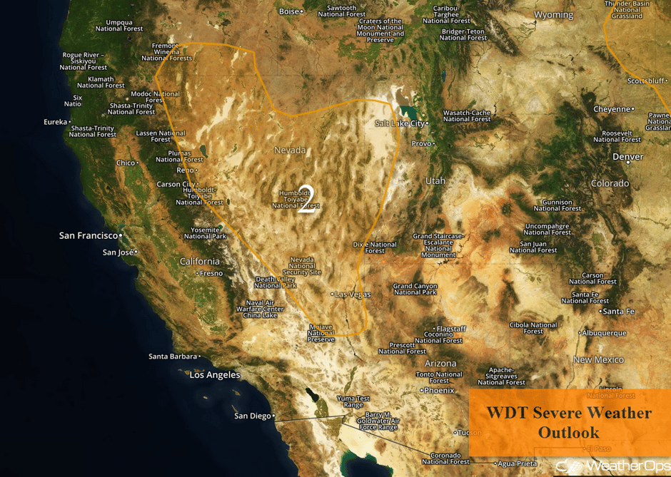 Region 2
Excessive Rainfall Continues Tuesday from the Southwest into the Great Basin
Monsoonal moisture will continue to promote rainfall and thunderstorms across the Western US today, with a flooding potential for the Southwest through Great Basin. Rainfall totals around an inch are expected with locally higher amounts in excess of 1.5 inches.
Major Cities in Region: Las Vegas, NV, Provo, UT
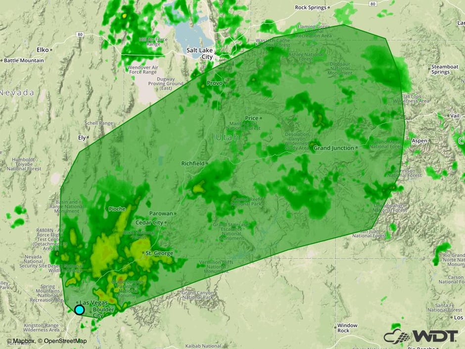 Excessive Rainfall Risk Outline for Tuesday
Potential for Thunderstorms from the Midwest through the Great Lakes on Wednesday
An area of low pressure and cold front will continue to move eastward on Wednesday across the Midwest and Great Lakes. Some ongoing showers and storms will be possible during the morning hours, but most activity should remain non-severe in nature. During the afternoon, new development along the cold front and perhaps any leftover boundaries from previous thunderstorms will occur. Clusters of thunderstorms and lines of storms may develop, as well as a few supercells. Large hail and damaging winds will be the primary hazards with these storms, but an isolated tornado cannot be ruled out. Heavy rain will also be a concern with the heaviest storms. Rainfall totals of 1-2 inches with locally higher amounts in excess of 2.5 inches are forecast.
Major Cities in Region: Sioux Falls, SD, Omaha, NE, Des Moines, IA, Minneapolis, MN, St. Louis, MO, Green Bay, WI, Milwaukee, WI, Chicago, IL, Indianapolis, IN, Cincinnati, OH
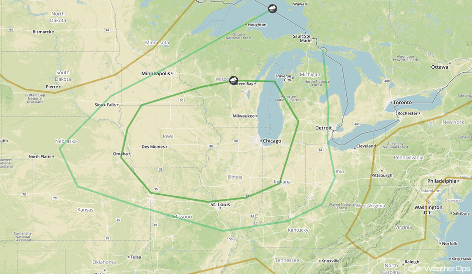 SPC Convective Outlook for Wednesday
Thunderstorm Risk Wednesday for the Intermountain West
Monsoonal moisture moving into the region along with an upper level trough will produce some areas of strong to severe thunderstorms. Large hail and damaging winds will be the primary hazards with these storms. Activity should weaken after sunset.
Major Cities in Region: Boise, ID, Salt Lake City, UT
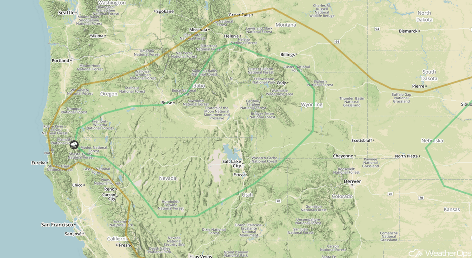 SPC Convective Outlook for Wednesday
Excessive Rainfall for Portions of Colorado and New Mexico on Wednesday
Monsoonal moisture will shift into the Rockies on Wednesday, allowing for some heavy rainfall and localized flooding. Rainfall totals of 1-1.5 inches are expected with locally higher amounts in excess of 2 inches in the heaviest downpours
Major Cities in Region: Aspen, CO, Santa Fe, CO
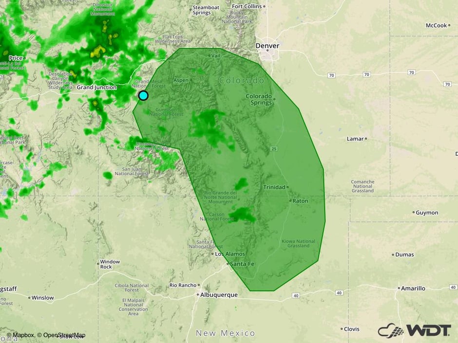 Excessive Rainfall Risk Outline for Wednesday
Strong to Severe Thunderstorms Thursday from the Mississippi Valley through the Mid Atlantic and Northeast
Ongoing showers and thunderstorms across the region from Wednesday will limit much of the severe potential for Thursday. However, instability should be sufficient for thunderstorms to develop during the day on Thursday. Damaging winds will be the primary hazard as storms evolve into lines. These storms will continue into the night time and overnight hours.
Major Cities in Region: St. Louis, MO, Memphis, TN, Milwaukee, WI. Chicago, IL, Indianapolis, IN, Nashville, TN, Detroit, MI, Cleveland, OH, Pittsburgh, PA, Raleigh, NC, Washington, DC, Philadelphia, PA, New York, NY
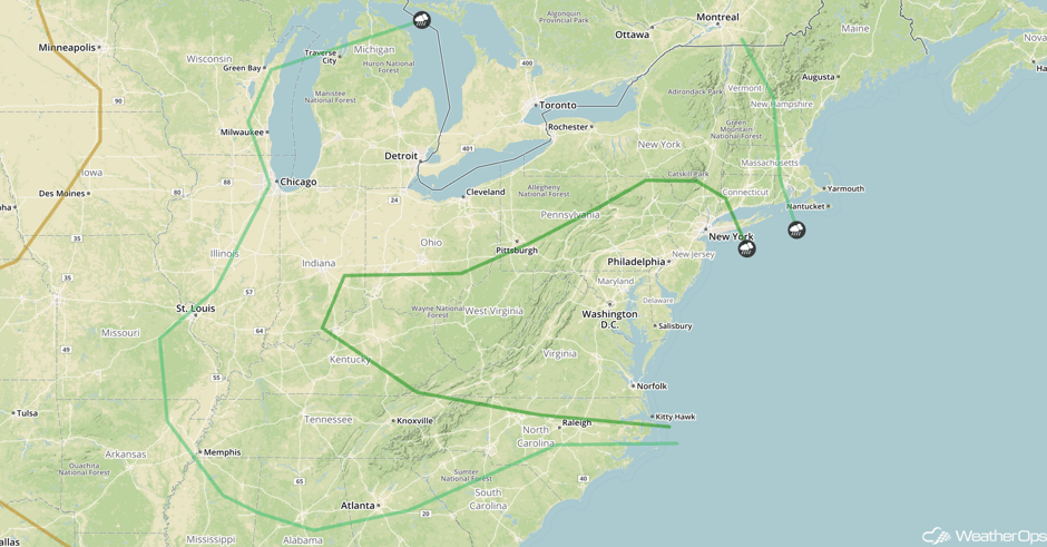 SPC Convective Outlook for Thursday
Thunderstorms for the Northern Rockies on Thursday
Thunderstorms may develop across the Northern Rockies on Thursday as an upper level trough moves across the region. Most storms should remain below severe limits, but a few storms could produce damaging winds. Storms should dissipate with the loss of daytime heating.
Major Cities in Region: Helena, MT, Great Falls, MT, Billings, MT, Cheyenne, WY
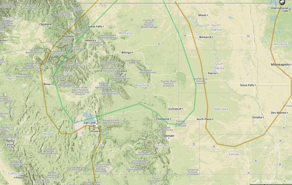 SPC Convective Outlook for Thursday
A Look Ahead
Thunderstorms may develop across the Tennessee Valley on Friday ahead of a cold front. Damaging winds will be the primary hazard with any storms that develop.
This is just a brief look at current weather hazards. We can provide you site-specific weather forecast information for the purpose of protecting your personnel and assets and to assess your weather risk. Try a 7-day demo right away and learn how timely precision weather information can enhance your bottom line.


