National Weather Summary for Tuesday, July 18, 2017
by David Moran, on Jul 18, 2017 11:13:05 AM
Thunderstorms may develop across the Northern Plains and Upper Midwest on Tuesday ahead of a cold front. There will be a risk for excessive rainfall across the Southwest on Tuesday.
- Thunderstorms across the Northern Plains and Upper Midwest on Tuesday
- Risk for Thunderstorms Tuesday across the Appalachians
- Excessive Rainfall Tuesday across the Southwest
- Continued Thunderstorms for the Northern Plains and Upper Midwest on Wednesday
- Excessive Rainfall Wednesday for the Intermountain West
- Risk for Thunderstorms for the Northern Plains on Thursday
- Thunderstorm Potential Thursday across the Midwest
- Continued Excessive Rainfall for the Intermountain West on Thursday
- Tropical Update
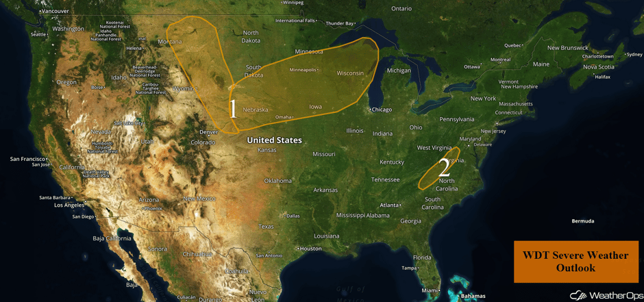 US Hazards
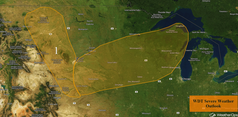
Thunderstorms across the Northern Plains and Upper Midwest on Tuesday
Daytime heating, sufficient moisture, and an upper level disturbance aloft will yield a marginal risk for isolated severe thunderstorms this afternoon. Storms are likely to develop along the higher terrain before moving eastward. Large hail and damaging winds will be the primary hazards, but an isolated tornado cannot be ruled out.
Further east, showers and thunderstorms are ongoing across portions of the Dakotas and Minnesota. This activity is not severe, however, storm intensity may increase during the midday and early afternoon as the leading line moves into central and eastern Minnesota. A broken line of developing storms is also forecast to extend southwestward into central Nebraska by mid afternoon. All of this activity is in response to moderate instability ahead of a cold front. Isolated severe thunderstorms that develop will have the potential to produce large hail and damaging winds with a lesser threat of tornadoes. Activity over Minnesota will slowly move into Wisconsin by the late afternoon and early evening. Activity should decrease after sunset.
Major Cities in Region: North Platte, NE, Sioux Falls, SD, Omaha, NE, Des Moines, IA, Minneapolis, MN, Green Bay, WI
 Region 1
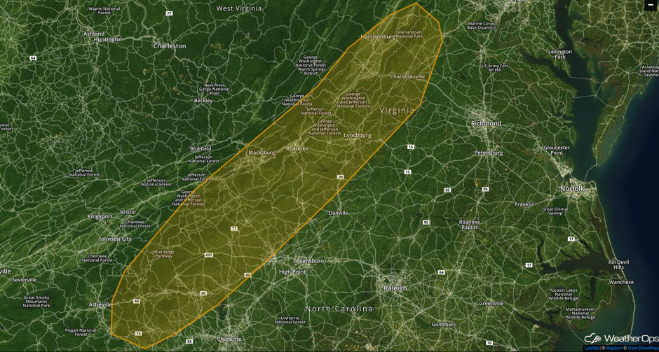
Risk for Thunderstorms Tuesday across the Appalachians
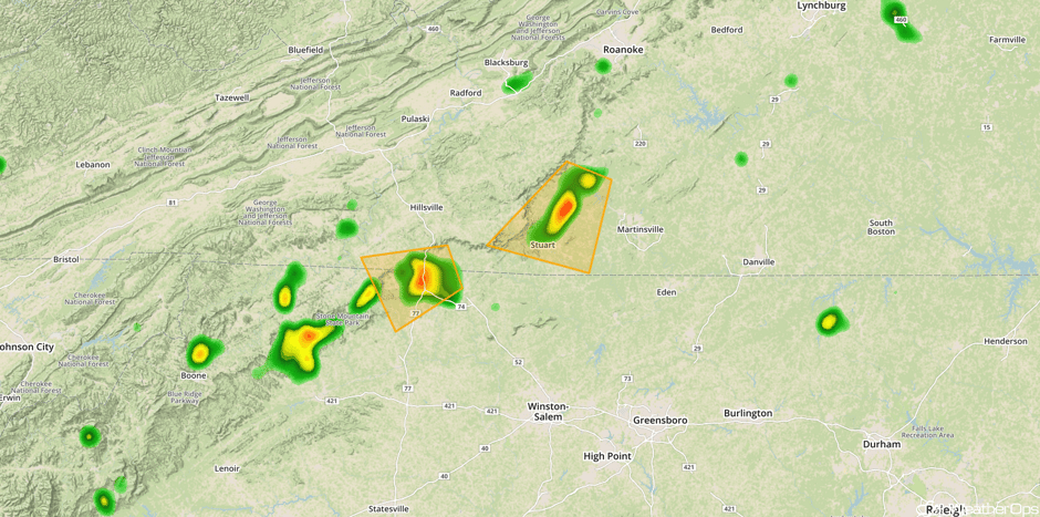
A weak area of low pressure and upper level disturbance will lead to the development of widely scattered thunderstorms by the mid to late afternoon. Widespread severe weather is not anticipated, but a few storms may contain large hail and damaging winds. Activity will diminish after sunset.
Update 2:27pm EDT: Severe thunderstorms capable of hail and damaging winds in southwestern Virginia and northwestern North Carolina.
 Radar 2:27pm EDT
Major Cities in Region: Roanoke, VA, Lynchburg, VA
 Region 2
Excessive Rainfall Tuesday across the Southwest
Isolated to scattered afternoon and early evening shower and thunderstorm development is anticipated across portions of the Southwest today. While general rainfall amounts will be an inch or less, some areas of locally heavy rainfall will be possible and could lead to some flooding issues.
Major Cities in Region: Las Vegas, NV, Flagstaff, AZ
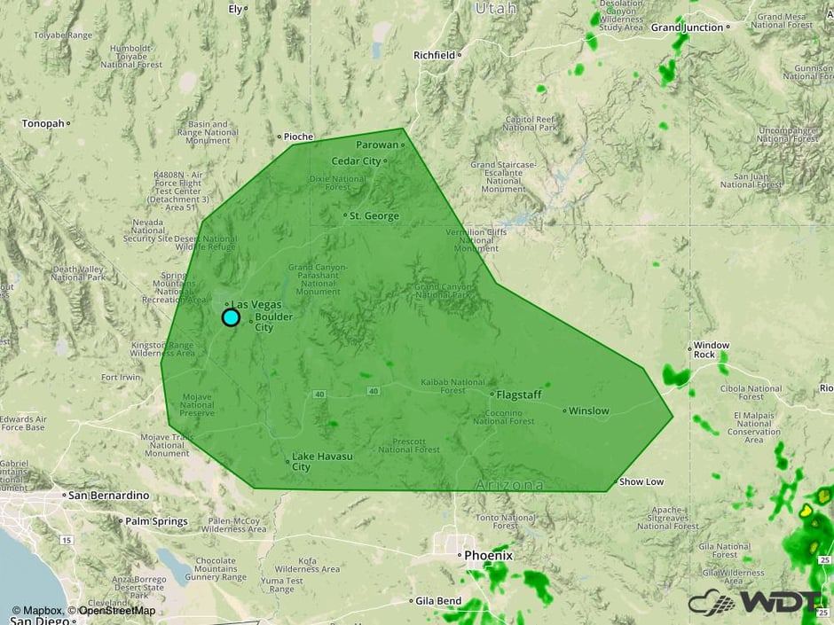 Excessive Rainfall Risk Outline for Tuesday
Continued Thunderstorms for the Northern Plains and Upper Midwest on Wednesday
An area of low pressure is expected to develop across the Northern Plains on Wednesday. This area of low pressure is forecast to track east-southeast during the day, with thunderstorms developing in its vicinity. Thunderstorms may develop during the morning, but the main threat will be during the afternoon and evening. Some storms may be strong to severe capable of producing gusty winds and hail. This activity may evolve into a complex during the overnight hours as it moves through the Upper Mississippi Valley. In addition, there will be a risk for excessive rainfall across the Upper Mississippi Valley. Rainfall amounts of 0.50-1.50 inches with locally higher amounts in excess of 2 inches are forecast. Due to the heavy rain on both Tuesday and Wednesday, there may be an increased risk of flooding across the region.
Major Cities in Region: Scottsbluff, NE, North Platte, NE, Pierre, SD, Sioux Falls, SD, Omaha, NE, Des Moines, IA, Minneapolis, MN, Green Bay, WI
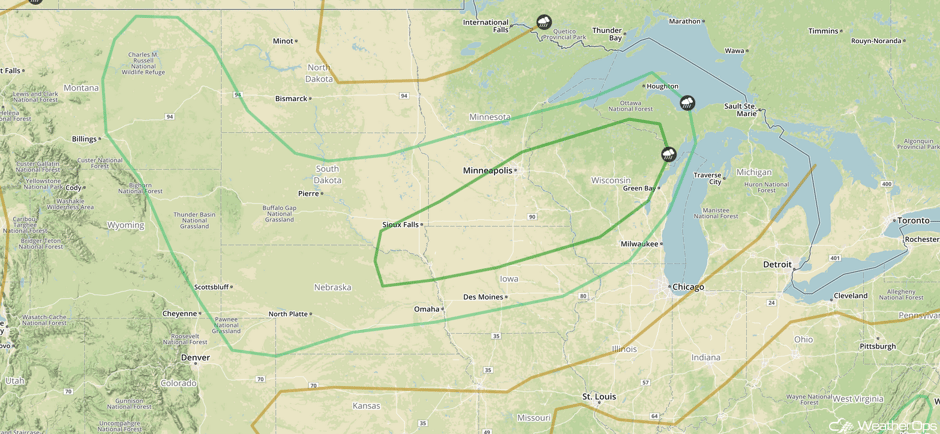 SPC Convective Outlook for Wednesday
Excessive Rainfall Wednesday for the Intermountain West
A weak area of low pressure setting up over the western US combined with favorable lift from the elevated terrain will allow for shower and thunderstorm development across portions of Utah and northwestern Arizona from late morning through early evening. Widespread excessive rainfall is not anticipated, but locally heavy rainfall amounts of 0.25-0.75 inch, with locally heavier amounts in excess of an inch is forecast.
Major Cities in Region: Salt Lake City, UT
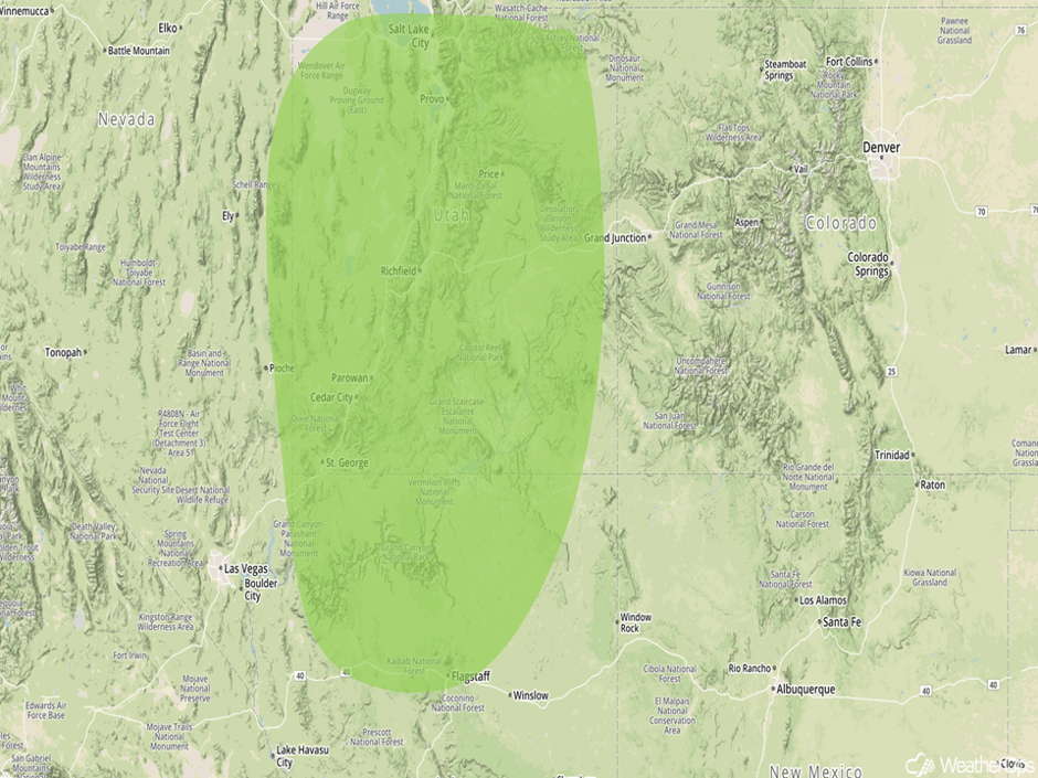 Excessive Rainfall Risk Outline for Wednesday
Risk for Thunderstorms for the Northern Plains on Thursday
An area of low pressure will gradually organize as it moves southeastward out of Canada. A warm front extending to the east will help focus afternoon and evening thunderstorm development across the region, with conditions expected to be favorable for at least a few strong to severe thunderstorms. Thunderstorms should begin to weaken by the late evening hours. Gusty winds and hail will be the primary hazards with these storms.
Major Cities in Region: Sioux Falls, SD, Minneapolis, MN
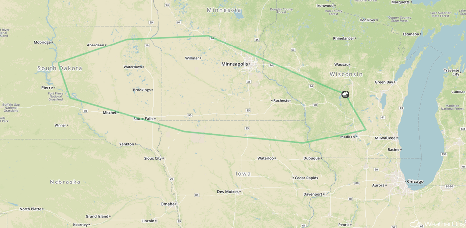 SPC Convective Outlook for Thursday
Thunderstorm Potential Thursday across the Midwest
During the morning hours on Thursday, a thunderstorm complex may be ongoing across portions of the Midwest near and to the north of a stalled frontal boundary. These storms will likely track eastward through the morning and early afternoon. Some storms may be strong, but should weaken with time. These storms will leave outflow boundaries that will aid in the development of additional thunderstorms by late afternoon and these storms could persist into the overnight hours. Conditions are expected to be favorable for at least a marginal risk for severe thunderstorms, with gusty winds and hail the main threats. A persistent heavy rain threat centered around the Upper Mississippi Valley will continue as well, with general rainfall amounts of 0.50-1.50 inches and locally higher amounts in excess of 2 inches. This may lead to an increased risk of flooding due to heavy rain from previous days.
Major Cities in Region: Sioux Falls, SD, Sioux City, IA, Milwaukee, WI, Chicago, IL, Toledo, OH
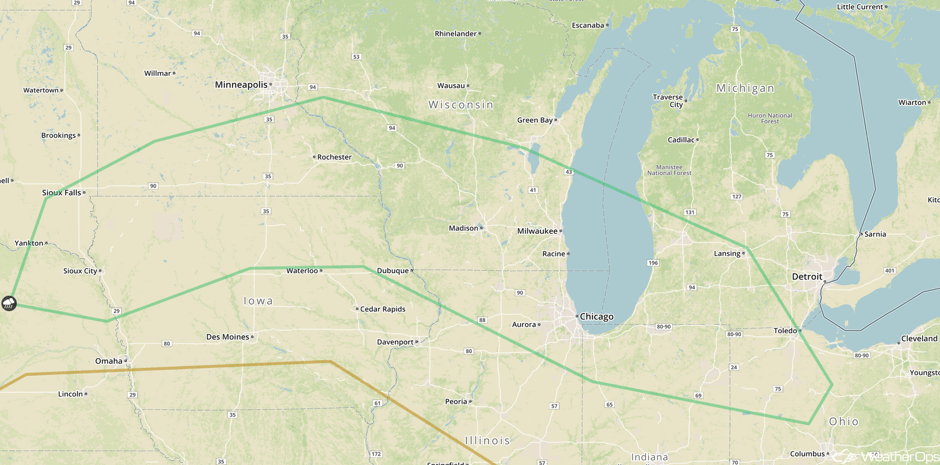 SPC Convective Outlook for Thursday
Continued Excessive Rainfall for the Intermountain West on Thursday
Shower and thunderstorm development is anticipated again on Thursday across portions of the Intermountain West, primarily from late morning through early evening. Rainfall amounts will range 0.25-0.75 inch with locally higher amounts in excess of an inch. This may lead to an increased risk of flooding or runoff for areas that have already received heavy rain.
Major Cities in Region: Provo, UT
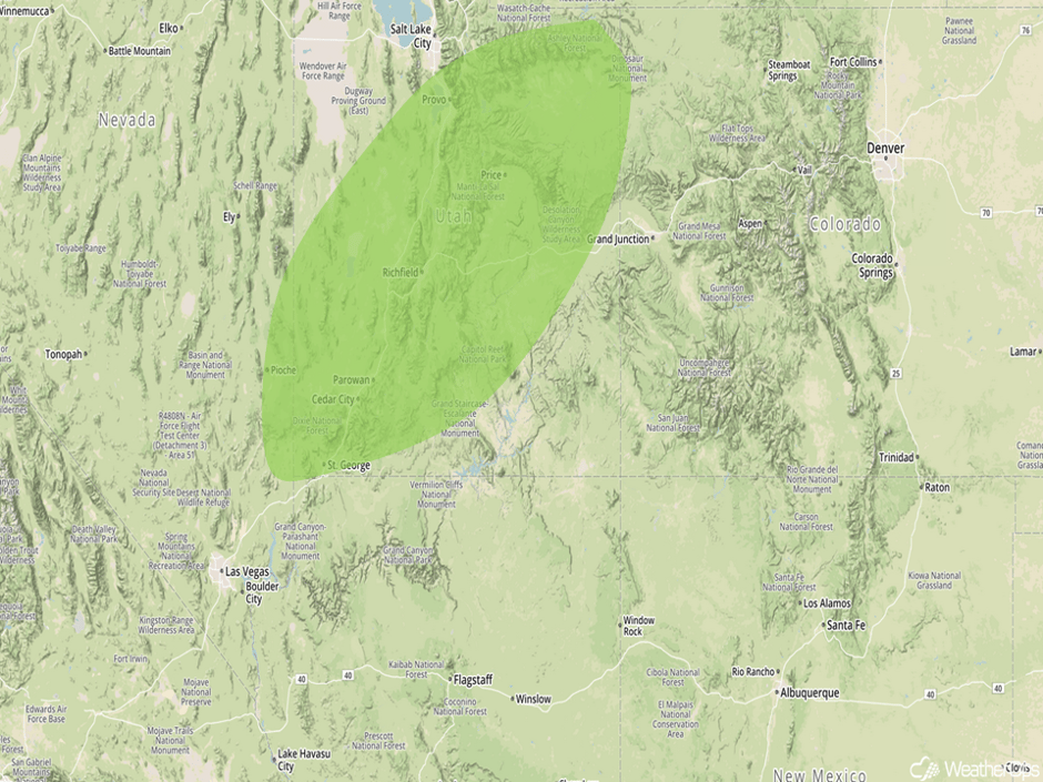 Excessive Rainfall Risk Outline for Thursday
Tropical Update
Tropical Storm Don (green oval) is moving westward at 20 mph. This general motion is expected to continue through Wednesday. On the current forecast track, the center will track across the Windward Islands later today or tonight and then move into the Caribbean Sea on Wednesday. Maximum sustained winds are at 40 mph with higher gusts. Don is expected to become a remnant low Wednesday or Wednesday night.
Further east, an area of showers and thunderstorms (red oval) is associated with an area of low pressure west-southwest of the Cabo Verde Islands. Some gradual development is possible through mid week while moving toward the west-northwest or northwest. Environmental conditions will then become less conducive for development.
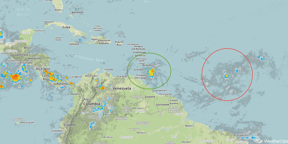 Enhanced Infrared Tropical Satellite
A Look Ahead
Thunderstorms will continue across the Northern Plains and Upper Midwest on Friday along a warm front associated with an area of low pressure. Thunderstorms will develop during the afternoon and evening, with gusty winds and hail the primary hazards. Storms will continue across the Upper Midwest into Saturday.
This is just a brief look at current weather hazards. We can provide you site-specific weather forecast information for the purpose of protecting your personnel and assets and to assess your weather risk. Try a 7-day demo right away and learn how timely precision weather information can enhance your bottom line.


