National Weather Summary for Tuesday, January 17, 2017
by David Moran, on Jan 17, 2017 11:20:37 AM
Thunderstorms may develop along a stalled front across portions of south Texas on Tuesday. Wintry precipitation will continue across the Great Lakes and Northeast as an area of low pressure moves eastward across these regions. A storm system approaching the Pacific Northwest will allow for heavy snowfall across the region.
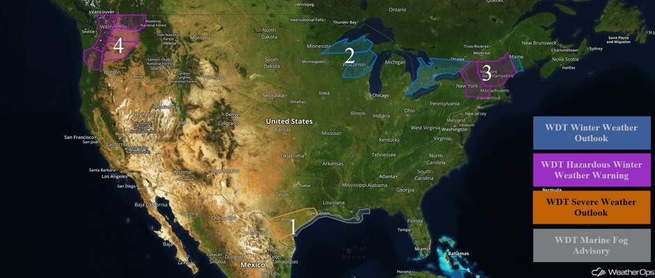 US Hazards
Region 1
A nearly stationary front will remain across south and southeast Texas today. At the same time, an upper level low, currently over northern Mexico, will increase shear across the region. While instability is not expected to be overly strong, conditions will support an isolated threat for severe weather this afternoon and early evening. Severe winds will be the primary hazard, but large hail and an isolated tornado or two cannot be ruled out. Along the Texas and Louisiana coasts, fog will persist through the day with visibilities less than 2 miles at times.
Major Cities in Region: Laredo, TX, San Antonio, TX, Corpus Christi, TX, Houston, TX
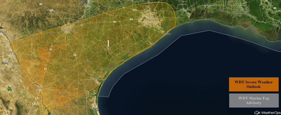 Region 1
Region 2
Snow will continue for portions of the Great Lakes through Tuesday afternoon as an area of low pressure moves northeastward. Snowfall totals of 1-3 inches with isolated higher amounts in excess of 4 inches are forecast in addition to freezing rain accumulations of up to a tenth of an inch.
Major Cities in Region: Oshkosh, WI, Green Bay, WI
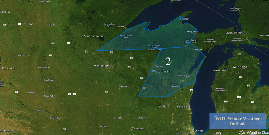 Region 2
Region 3
An area of low pressure moving eastward from the Great Lakes and into the Northeast is expected to spread wintry precipitation across Region 3 this morning and continue into Wednesday morning. A mix of rain, freezing rain, and snow is expected. The primary hazard will be freezing rain with accumulations between a tenth and a quarter inch of ice and isolated higher amounts in excess of 0.35 inch. In addition, snow and sleet accumulations of 1-3 inches with locally higher amounts in excess of 4 inches are expected. Travel difficulties may develop into early Wednesday. Further east across Maine, 1-2 inches of snow with isolated higher amounts in excess of 3 inches are forecast.
Major Cities in Region: Albany, NY, Bangor, ME
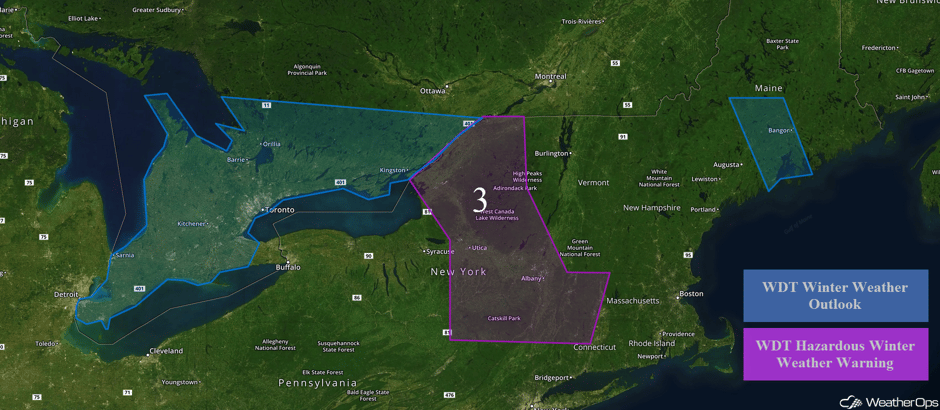 Region 3
Region 4
As a storm system moves into the Pacific Northwest, there will be a threat of wintry precipitation through Thursday. Snow will likely develop and increase in coverage across the higher terrain this morning and continue into the evening hours. Snow accumulations of 1-2 feet will be possible. Below 500 feet, precipitation will be in the form of freezing rain before transitioning to liquid rain later in the day. Ice accumulations between a tenth and a quarter of an inch are expected with some travel difficulties across the region. From northeastern Oregon to east central Washington, 1-2 inches of snow with locally higher amounts in excess of 3 inches are expected. In addition, ice accumulations between a tenth and a quarter of an inch are expected with locally higher amounts. Across northeastern Washington and northern Idaho, snowfall totals of 3-6 inches with isolated higher amounts in excess of 8 inches are expected in the valleys. In the higher elevations, snowfall amounts will range between 10 and 20 inches. Ice accumulations will range between a tenth and a quarter inch of ice.
Major Cities in Region: Portland, OR, Yakima, WA, Spokane, WA
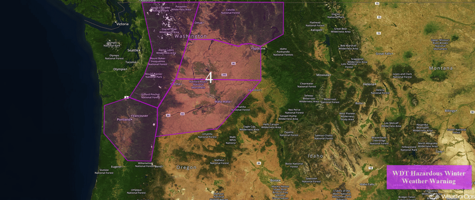 Region 4
Excessive Rainfall Possible for the Pacific Northwest Tuesday and Wednesday
A series of storm systems will bring plentiful precipitation to portions of the Pacific Northwest with the highest potential for flooding along the coast of the Pacific Northwest. Two day rainfall totals of 5-10 inches with isolated higher amounts are expected. By Wednesday, heavy rain will spread into northern California.
Major Cities in Region: Seattle, WA, Portland, OR, Eureka, CA, San Francisco, CA
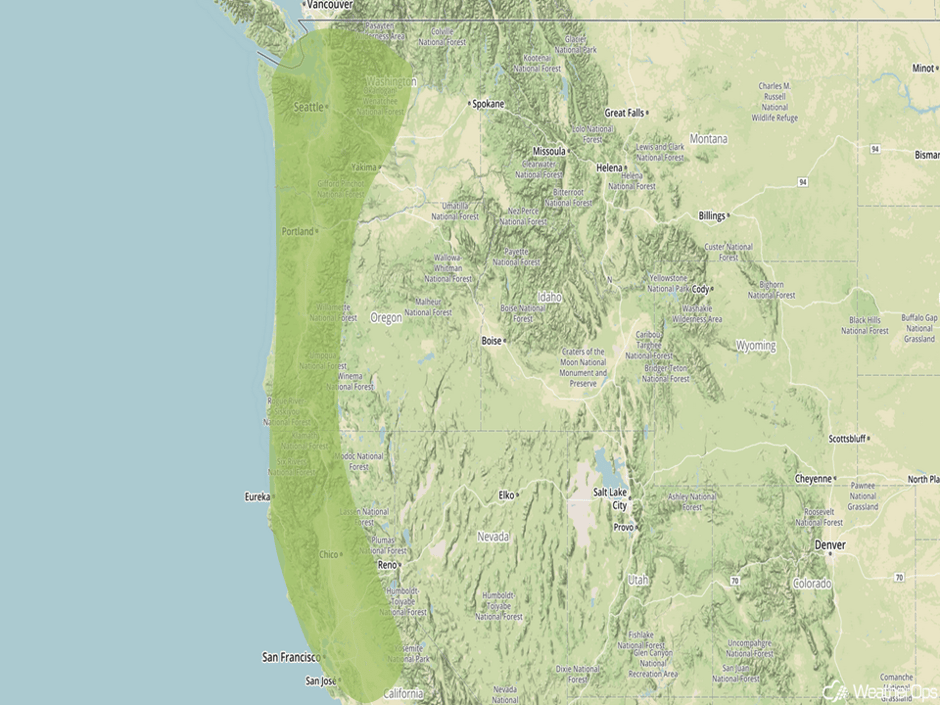 Significant Rainfall Risk Outline for Tuesday and Wednesday
Significant Snowfall Possible for Sierra Nevada on Wednesday
With an area of low pressure and cold front causing heavy rainfall across the region, heavy snowfall is also expected along the Sierra Nevadas. High elevations of 6-12 inches of snowfall are expected with locally higher amounts in excess of a foot in the highest elevations.
Major Cities in Region: Reno, NV
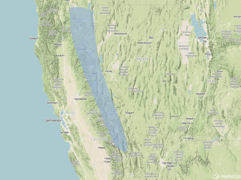 Significant Snowfall Risk Outline for Wednesday
Strong to Severe Thunderstorms Possible Thursday along the Gulf Coast
Severe thunderstorms will be possible along the Gulf Coast on Thursday as an area of low pressure and associated cold front begins to move eastward. Thunderstorms are expected during the afternoon as the front moves into the region. Large hail and damaging winds will be the primary hazards, but locally heavy rainfall may also develop.
Major Cities in Region: New Orleans, LA, Jackson, MS, Mobile, AL
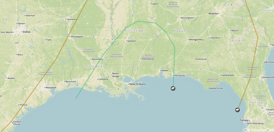 SPC Convective Outlook for Thursday
A Look Ahead
An area of low pressure and cold front may allow for the development of thunderstorms along the northern Gulf Coast on Saturday. Large hail, damaging winds, and tornadoes will be possible with these storms. Flooding may also occur in locally heavy downpours.
This is just a brief look at current weather hazards. We can provide you site-specific forecast information for the purpose of protecting your personnel and assets. Try a 7-day demo right away and learn how timely precision weather information can enhance your bottom line.


