


by David Moran, on Feb 26, 2019 10:44:11 AM
Thunderstorms will increase along the Gulf Coast on Tuesday as an area of low pressure moves eastward. Excessive rainfall will continue across northern California along a stalled front. Snow will continue from the western US into the Northern Rockies as a trough moves across the region. An upper level disturbance will produce snow from the Northern Plains into the Northeast through Wednesday. Fog will continue along the Texas and Louisiana coasts through Thursday.
- Thunderstorms for the Gulf Coast on Tuesday
- Excessive Rainfall Tuesday across Northern California
- Snow from the Western US to the Northern Rockies through Wednesday
- Potential for Snow through Wednesday from the Northern Plains into the Northeast
- Fog along the Texas and Louisiana Coasts through Thursday
- Wintry Precipitation Wednesday and Thursday from the Central Plains into the Ozarks
- Thunderstorms for the Eastern Gulf Coast on Thursday
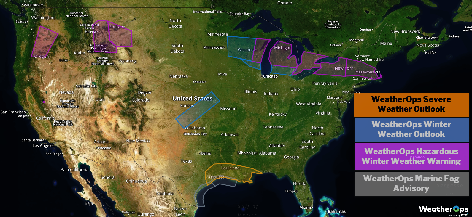
US Hazards
Thunderstorms for the Gulf Coast on Tuesday
Moisture will increase on Tuesday while an upper level system moves across the region. This will allow for the development of thunderstorms, some of which may become severe. Damaging winds and large hail will be the primary hazards from southeast Texas eastward across southern Louisiana from the early afternoon through the late night hours. The thunderstorm potential across southern Louisiana may be the highest during the overnight and early morning hours Wednesday.
Major Cities in Region: Houston, TX, Beaumont, TX, Lake Charles, LA, New Orleans, LA
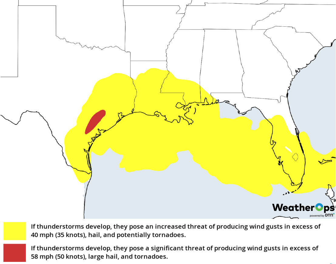
Thunderstorm Risk for Tuesday
Excessive Rainfall Tuesday across Northern California
A stalled front is producing numerous showers across northern California this morning. The front is unlikely to progress much over the next 12-24 hours, allowing rainfall to continue as Pacific moisture streams into the region. Additional rainfall amounts of 1-3 inches are expected for the lower elevations. Across the higher elevations, 4-7 inches are forecast.
Major Cities in Region: Eureka, CA, San Francisco, CA, Chico, CA
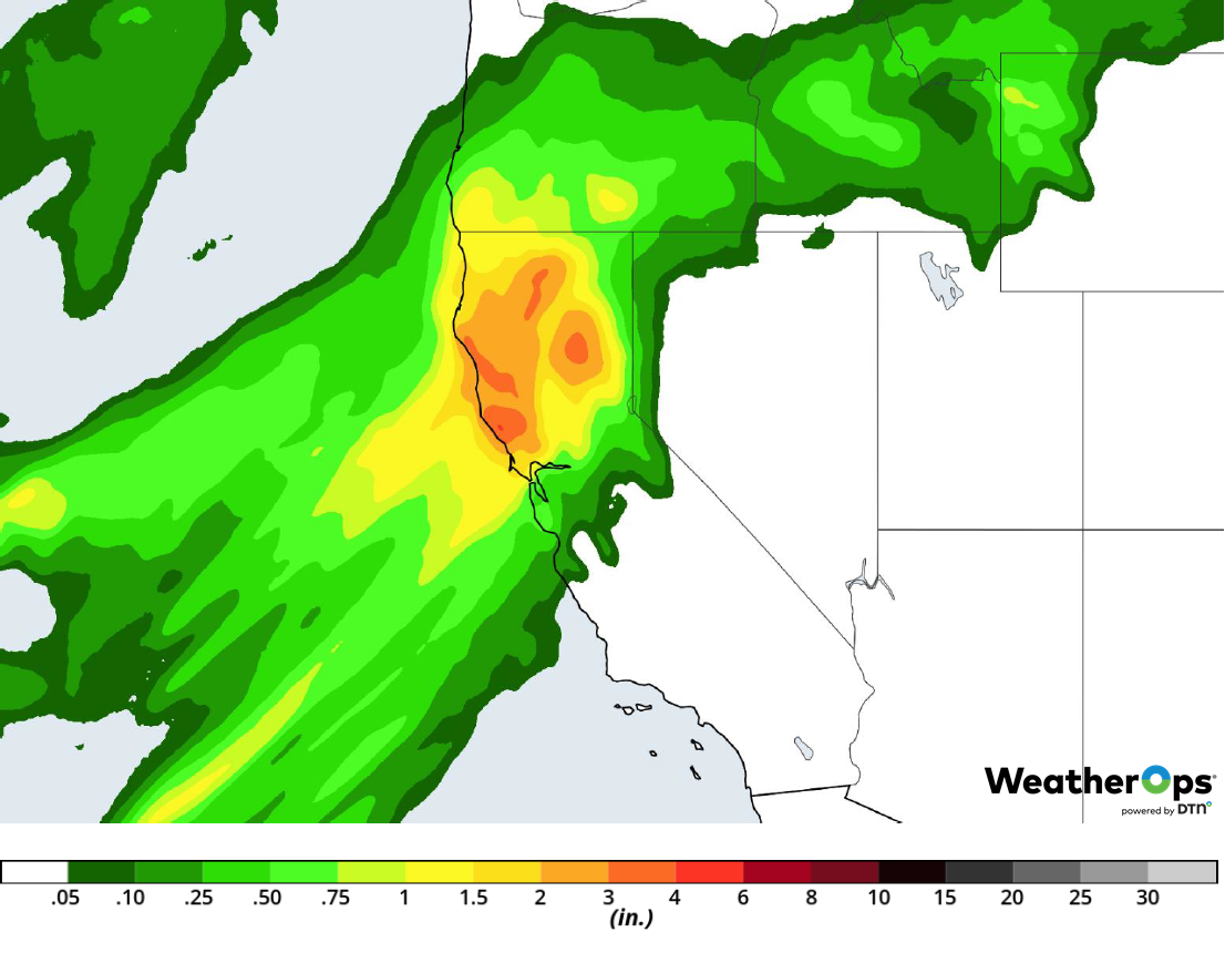
Rainfall Accumulation for Tuesday
Snow from the Western US to the Northern Rockies through Wednesday
Moderate to heavy snowfall will continue from the Sierra Nevadas and Cascades into the Northern Rockies as an area of low pressure slowly moves eastward. Snowfall accumulations will be highest in the Sierra Nevadas where an additional 1-2 feet are expected. Elsewhere, 4-8 inches with locally higher amounts in excess of 10 inches are expected in the lower elevations. For the higher elevations, 8-14 inches with locally higher amounts in excess of 18 inches are forecast. In addition, gusty winds will result in blowing snow and near zero visibility in some areas.
Major Cities in Region: Bend, OR, Idaho Falls, ID, Cody, WY
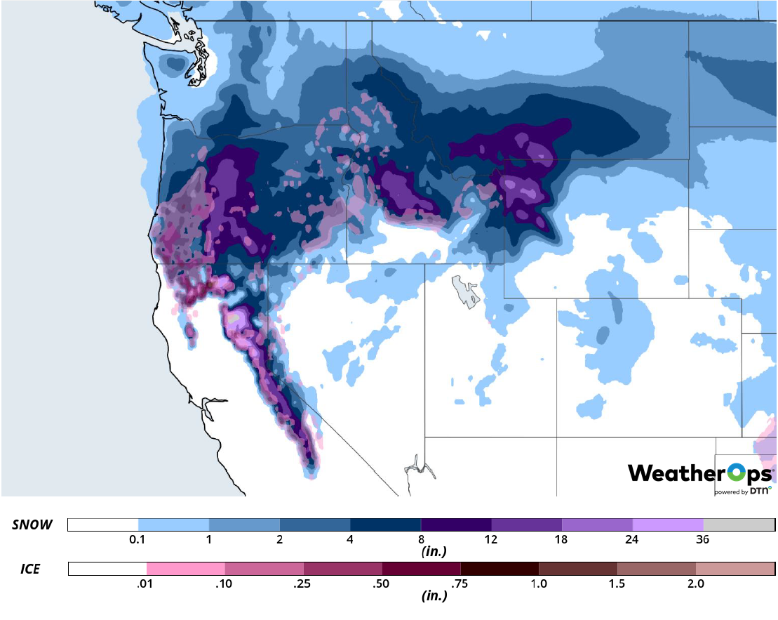
Snow Accumulation through Wednesday
Potential for Snow through Wednesday from the Northern Plains into the Northeast
An upper level disturbance moving out of Canada and eastward across the northern US will bring moderate to heavy snow to the Northern Plains today. This snow will move into the Northeast tomorrow. Snowfall accumulations of 4-6 inches are likely from central and northern portions of Wisconsin into Michigan through midday Wednesday. The heaviest snow will be across portions of western New York where 6-8 inches are expected.
Major Cities in Region: Grand Forks, ND, Duluth, MN, Green Bay, WI, Grand Rapids, MI, Detroit, MI, Buffalo, NY, Albany, NY
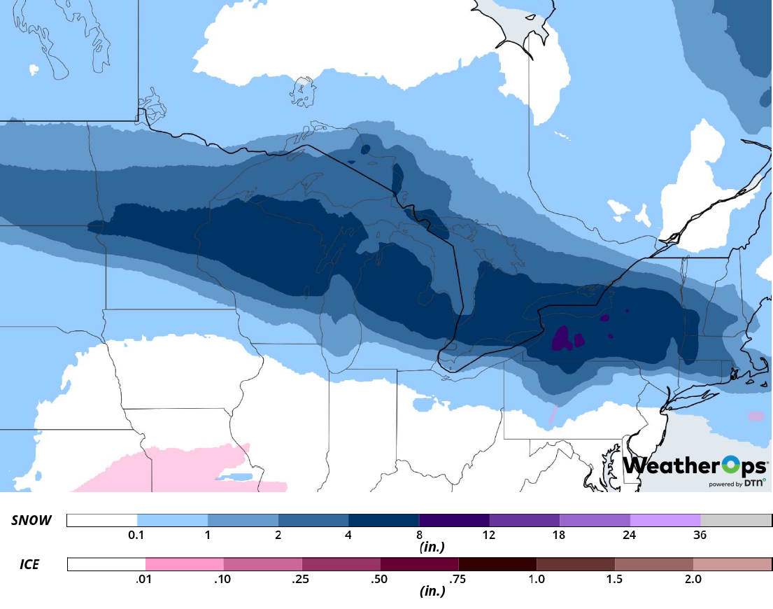
Snow Accumulation through Wednesday
Fog along the Texas and Louisiana Coasts through Thursday
Weak onshore winds and plentiful moisture will allow fog to persist along the Texas and Louisiana coasts through Thursday. Visibilities will be less than a mile at times.
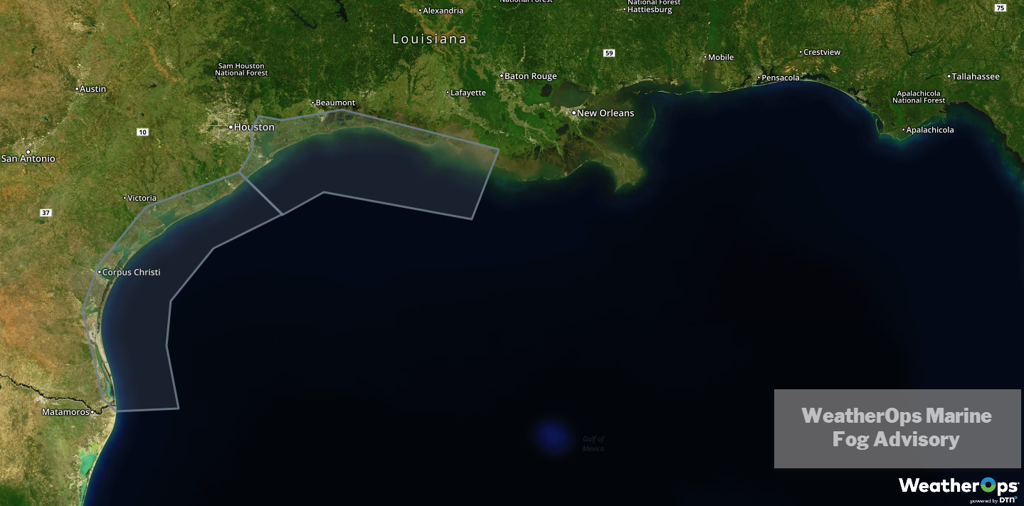
WDT Marine Fog Advisory
Wintry Precipitation Wednesday and Thursday from the Central Plains into the Ozarks
Isolated rain showers may be ongoing along a nearly stationary front across portions of northern Oklahoma and southern Kansas late Tuesday night into early Wednesday morning. Meanwhile, cold air will move southward along the lee side of the Rockies. As a result, light rain showers may transition to freezing rain and sleet. This precipitation will shift into southern Missouri and Illinois Wednesday evening through Thursday morning. Ice accumulations up to 0.10 inch are expected. Caution is advised if travel is necessary, especially over bridges and overpasses.
Major Cities in Region: Dodge City, KS, Oklahoma City, OK, Wichita, KS, Tulsa, OK, Kansas City, MO, Springfield, MO, St. Louis, MO
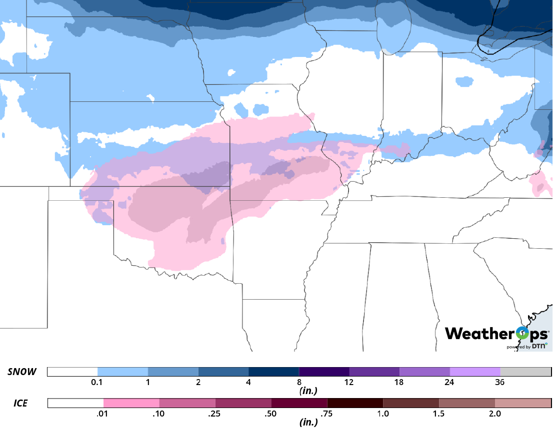
Snow Accumulation through Wednesday
Thunderstorms for the Eastern Gulf Coast on Thursday
Weak instability and wind shear will likely be present ahead of an approaching cold front on Thursday. If enough breaks in the cloud cover develop, daytime heating may produce enough instability for the development of thunderstorms, some of which may be severe. Damaging winds and hail will be the primary hazards with these storms.
Major Cities in Region: Mobile, AL, Pensacola, FL, Tallahassee, FL
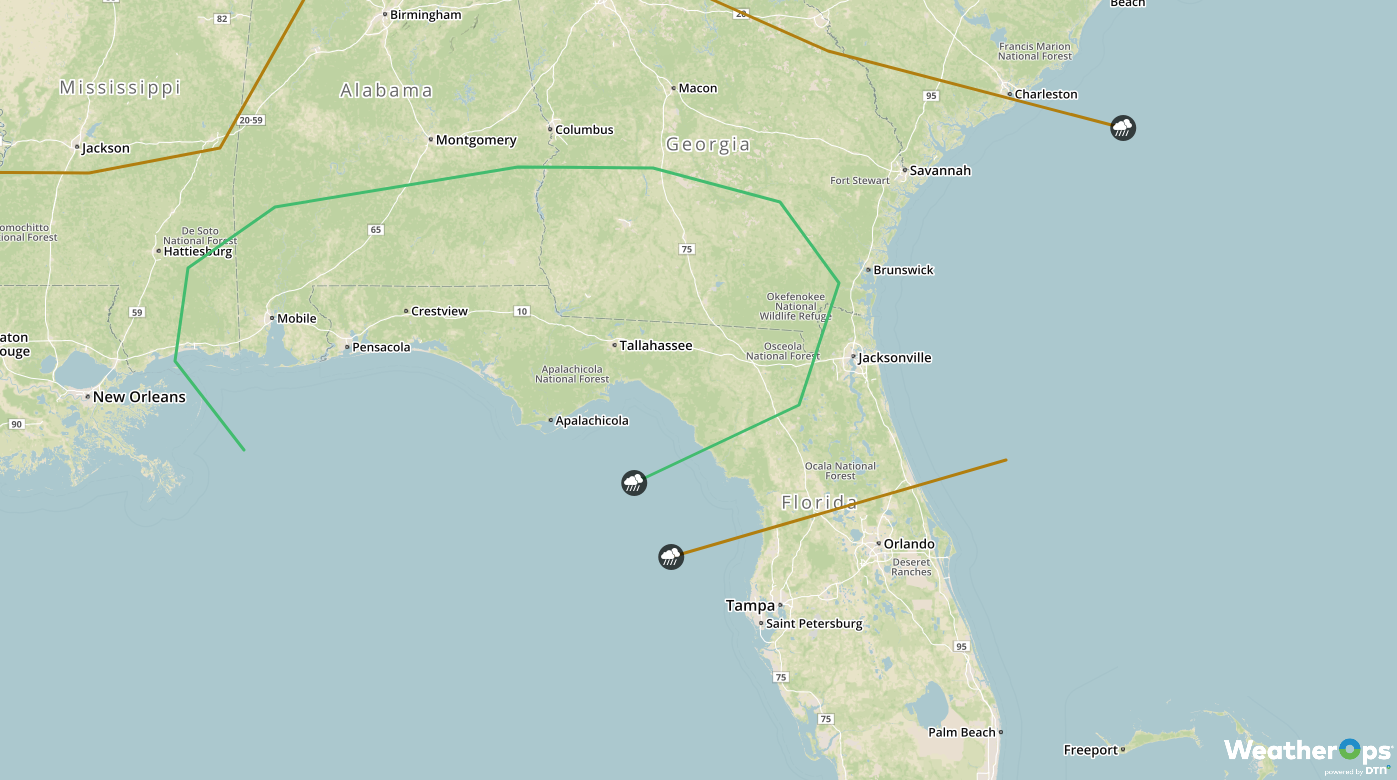
SPC Convective Outlook for Thursday
A Look Ahead
Wintry precipitation is forecast across the Northern and Central Plains on Friday as an area of low pressure moves across the region. This activity will extend from the Midwest into the Plains on Saturday. As the system continues to move eastward on Sunday, snow is forecast into the Northeast. A wintry mix may move into the Lower Mississippi Valley on Monday.
