


by David Moran, on Feb 19, 2019 10:48:47 AM
Thunderstorms will continue across the Lower Mississippi Valley on Tuesday as a warm front lifts northward. This activity will produce a risk for excessive rainfall from the Lower Mississippi Valley into the Lower Ohio Valley. Snow will continue across the Southern Rockies into northern New Mexico as an area of low pressure moves eastward. Freezing rain and snow are expected across the Central and Southern Plains in association with an area of low pressure. Elevated winds and seas will continue across the Gulf of Mexico through the afternoon as a cold front moves across the region.
- Thunderstorms across the Lower Mississippi Valley on Tuesday
- Excessive Rainfall Tuesday from the Lower Mississippi Valley into the Lower Ohio Valley
- Snow Continuing from the Southern Rockies into Northern New Mexico on Tuesday
- Freezing Rain and Snow Tuesday across the Central and Southern Plains
- Elevated Winds and Seas across the Gulf of Mexico through Tuesday Afternoon
- Potential for Thunderstorms Wednesday along the Gulf Coast
- Excessive Rainfall from the Gulf Coast into the Tennessee Valley on Wednesday
- Snow Wednesday across the Upper Midwest
- Potential for Snow from the Mid-Atlantic into the Northeast on Wednesday
- Snow Thursday across the Northeast
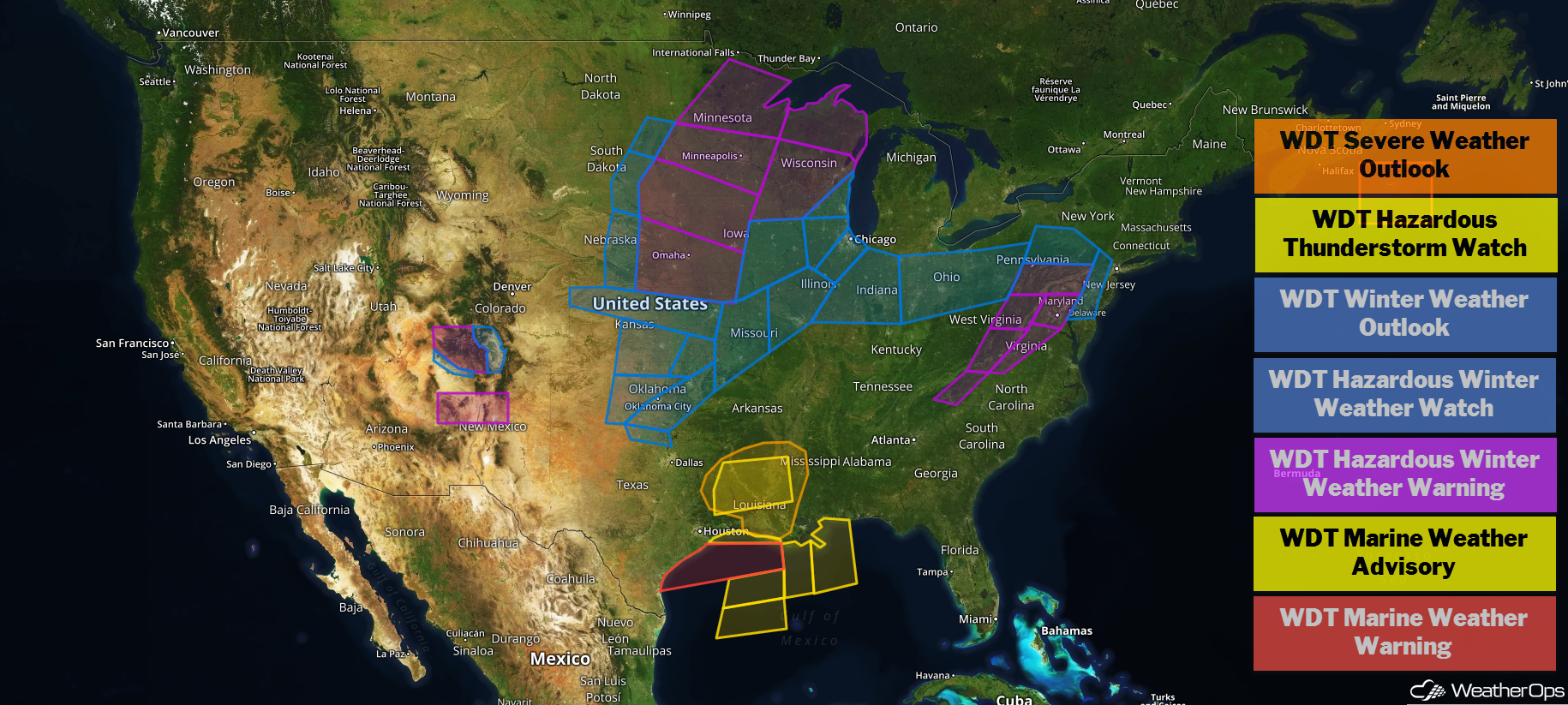
US Hazards
Thunderstorms across the Lower Mississippi Valley on Tuesday
There is a potential for strong to severe thunderstorms over the Lower Mississippi Valley on Tuesday as a warm front moves northward. Ongoing thunderstorms will persist through the day and may intensify during the afternoon as a cold front moves eastward. Damaging winds and large hail will be the primary hazards but an isolated tornado cannot be ruled out over Louisiana during the late afternoon into the early evening as the low level jet increases.
Major Cities in Region: Baton Rouge, LA, Jackson, MS, New Orleans, LA
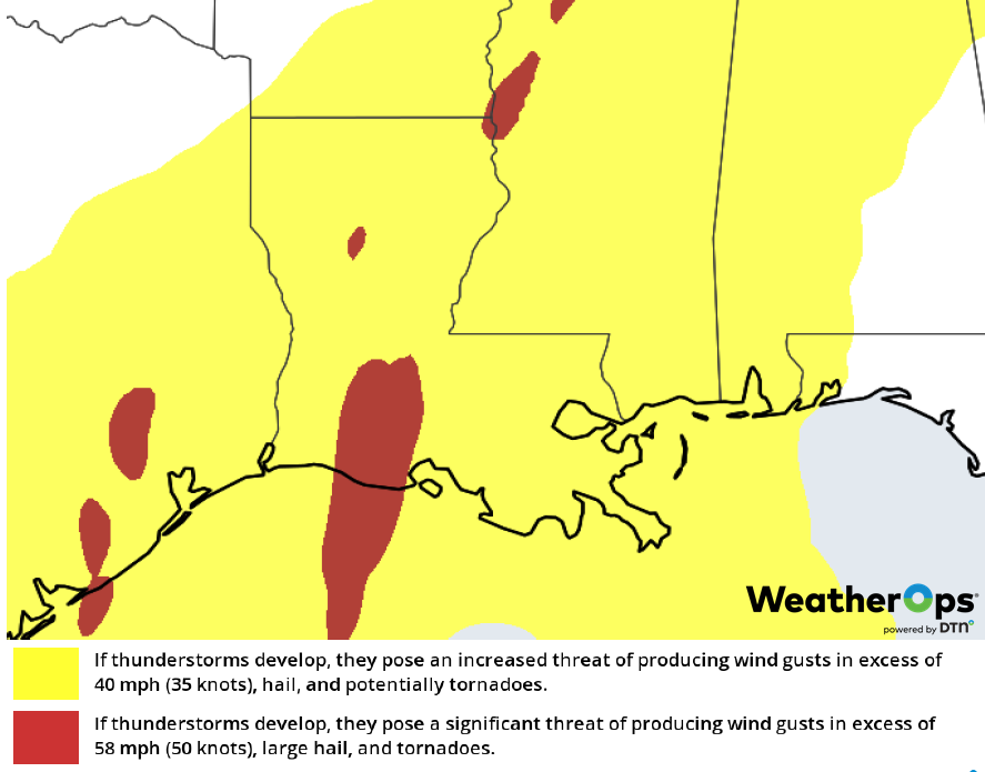
Thunderstorm Risk for Tuesday
Excessive Rainfall Tuesday from the Lower Mississippi Valley into the Lower Ohio Valley
In addition to the thunderstorms described above, there will be a potential for excessive rainfall from the Lower Mississippi Valley into the Lower Ohio Valley. Rainfall amounts of 2-4 inches with locally higher amounts in excess of 5 inches are forecast. This will likely lead to areas of flash flooding.
Major Cities in Region: Monroe, LA, Memphis, TN, Evansville, IN
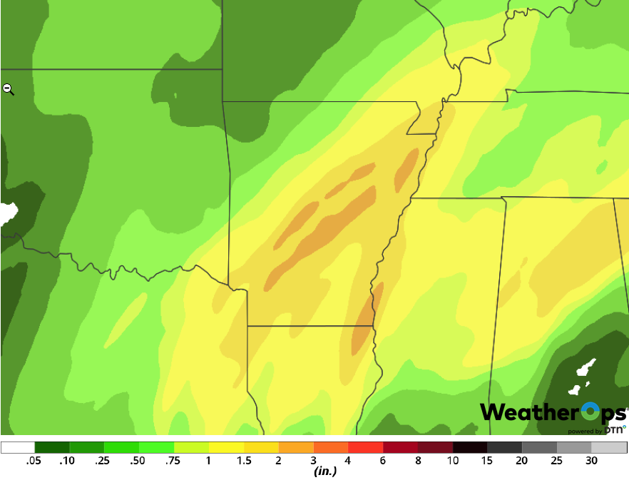
Rainfall Accumulation for Tuesday
Snow Continuing from the Southern Rockies into Northern New Mexico on Tuesday
A slow moving area of low pressure will continue to produce snowfall across the region on Tuesday. Snow accumulations will range 3-6 inches in the lower elevations; in the higher elevations, accumulations in excess of 8 inches are expected.
Major Cities in Region: Durango, CO, Albuquerque, NM, Santa Fe, NM, Alamosa, CO
Snow Accumulation for Tuesday
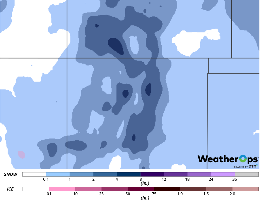
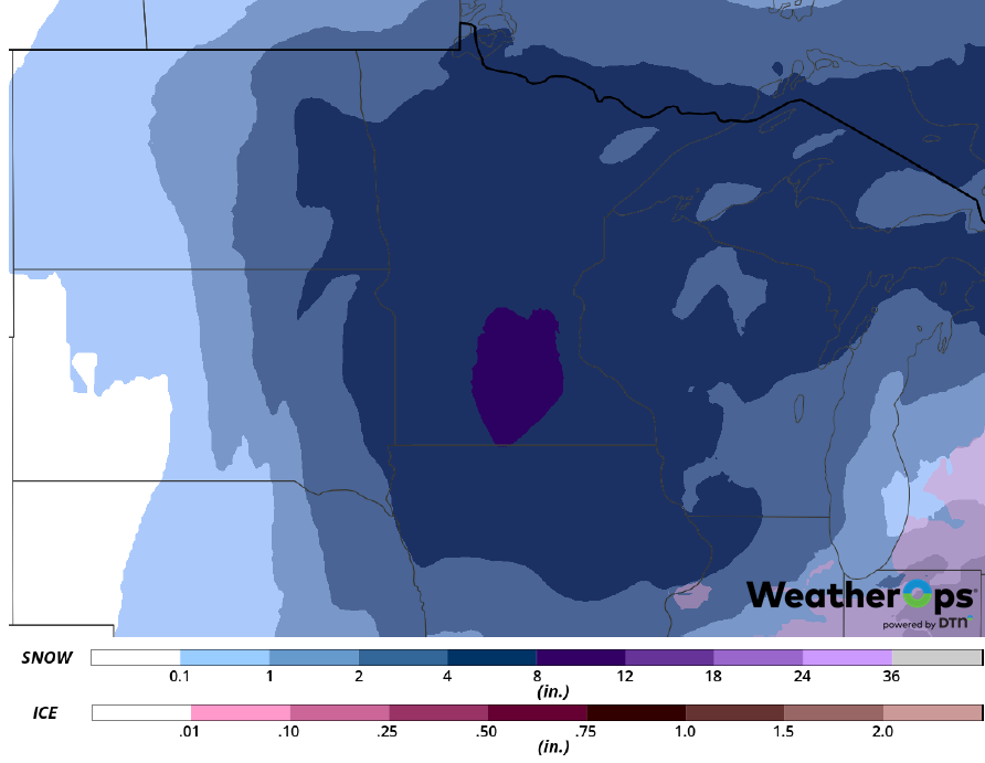
Freezing Rain and Snow Tuesday across the Central and Southern Plains
Widespread moisture will move northward from the Gulf of Mexico through the day. At the same time, an area of low pressure will move eastward out of the Four Corners region. This will produce a wintry mix over portions of Oklahoma and the Ozarks. Further north, snow is expected, with some heavy snow across central Kansas. Snow accumulations will range 4-7 inches with locally higher amounts in excess of 8 inches. Further south, freezing rain is expected across central and southern Oklahoma. Ice accumulations will range 0.05-0.15 inch with locally higher amounts in excess of 0.20 inch. Roads will become slick and hazardous across the region. Power outages may occur where the ice accumulation is heavier.
Major Cities in Region: Oklahoma City, OK, Wichita, KS, Lincoln, NE, Topeka, KS, Tulsa, OK, Omaha, NE, Kansas City, MO
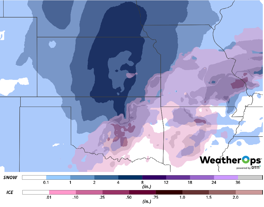
Snow and Ice Accumulation for Tuesday
Elevated Winds and Seas across the Gulf of Mexico through Tuesday Afternoon
Elevated winds and seas will continue across the Gulf of Mexico through Thursday afternoon as a cold front continues to move eastward. Winds will range 25-30 knots with gusts in excess of 40 knots. Seas will be 7-12 feet in the deeper waters and 6-8 feet near the shore.
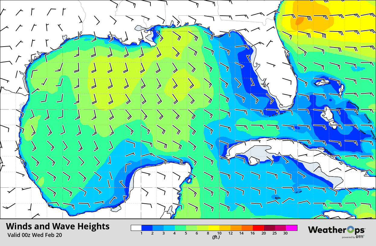
Winds and Wave Heights 6pm CST Tuesday
Potential for Thunderstorms Wednesday along the Gulf Coast
The potential for strong to severe thunderstorms will shift slightly eastward into the Alabama/Mississippi Gulf Coast region on Wednesday. Widely scattered to scattered showers and thunderstorms will be ongoing during the morning and persist into the afternoon as a cold front begins to stall. The thunderstorm potential will increase during the afternoon and early evening as the low level jet increases. Damaging winds and isolated tornadoes will be the primary hazards with these storms.
Major Cities in Region: Baton Rouge, LA, Jackson, MS, New Orleans, LA, Biloxi, MS
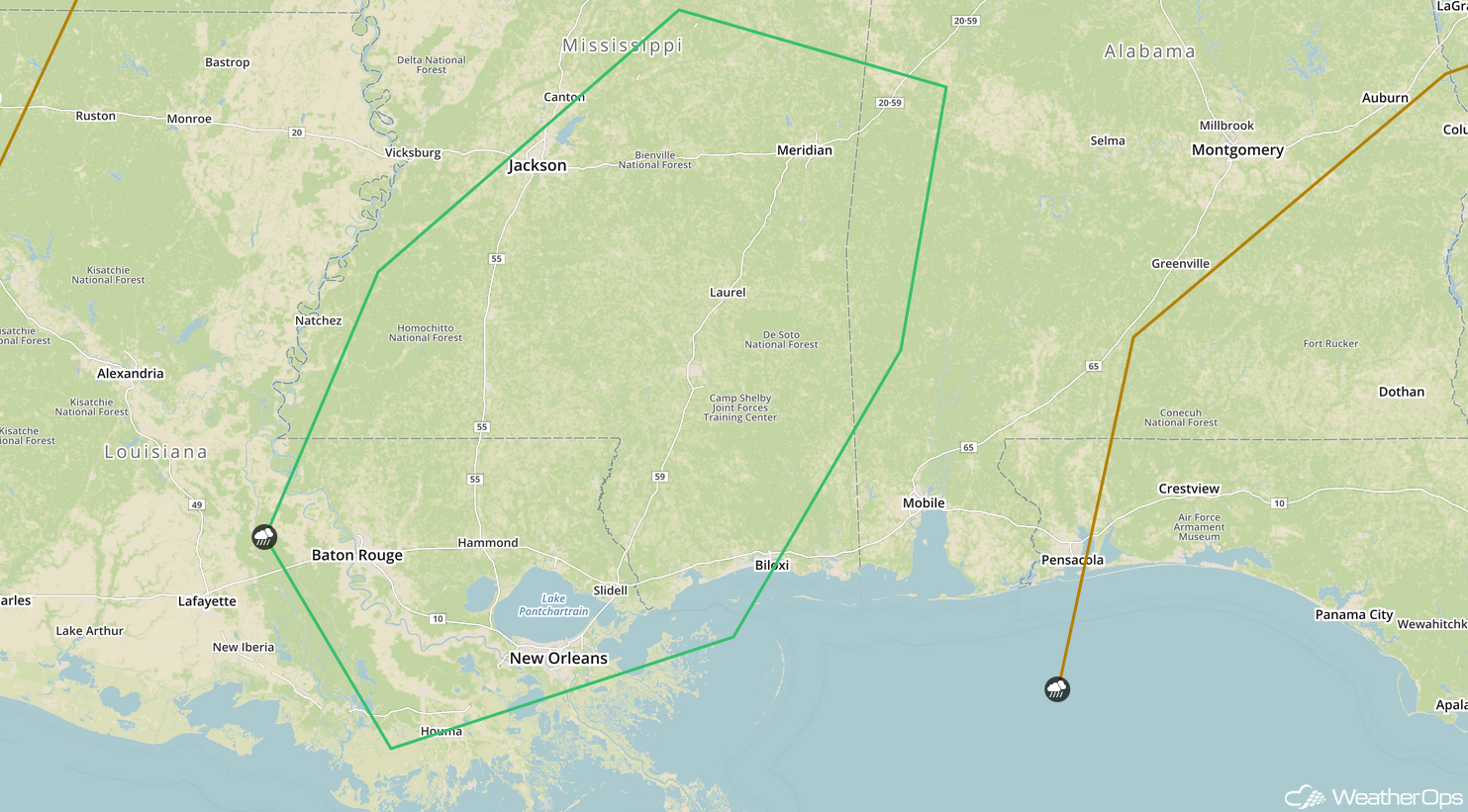
SPC Convective Outlook for Wednesday
Excessive Rainfall from the Gulf Coast into the Tennessee Valley on Wednesday
The thunderstorms described above will have the potential to produce excessive rainfall from the Gulf Coast into the Tennessee Valley. Rainfall amounts of 1-3 inches with locally higher amounts in excess of 4 inches are forecast, leading to a risk for flash flooding.
Major Cities in Region: Biloxi, MS, Mobile, AL, Birmingham, AL, Chattanooga, TN
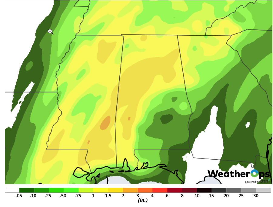
Rainfall Accumulation for Wednesday
Snow Wednesday across the Upper Midwest
Snow will continue northward into the Upper Midwest on Wednesday as another area of low pressure develops. Moderate to heavy snow will move through the region during the day and evening. Snowfall accumulations will range 4-8 inches with locally higher amounts in excess of 10 inches.
Major Cities in Region: Grand Forks, ND, Sioux Falls, SD, Minneapolis, MN, Duluth, MN
Snow Accumulation for Wednesday
Potential for Snow from the Mid-Atlantic into the Northeast on Wednesday
Widespread precipitation is expected over portions of the Mid Atlantic into the Northeast on Wednesday as an area of low pressure lifts northward. With plentiful moisture and enough cold air in place, moderate to heavy snow and significant icing are expected. Snow accumulations will range 4-8 inches with locally higher amounts in excess of 10 inches. Sleet accumulations up to 0.20 inch and ice accumulations ranging 0.05-0.20 inch with locally higher amounts in excess of 0.25 inch are expected.
Major Cities in Region: Roanoke, VA, Washington, DC, Baltimore, MD, Philadelphia, PA
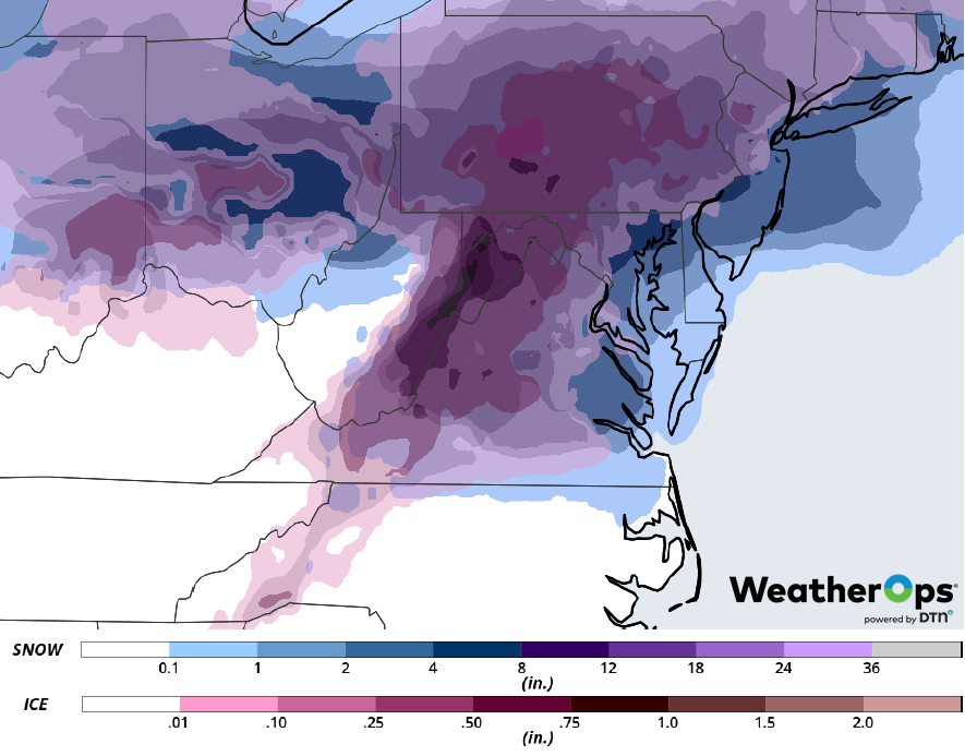
Snow and Ice Accumulation for Wednesday
Snow Thursday Across the Northeast
Moderate to heavy snowfall is expected across the Northeast as two areas of low pressure move across the region. Snowfall totals will range 4-8 inches with locally higher amounts in excess of 10 inches.
Major Cities in Region: Portland, ME, Bangor, ME
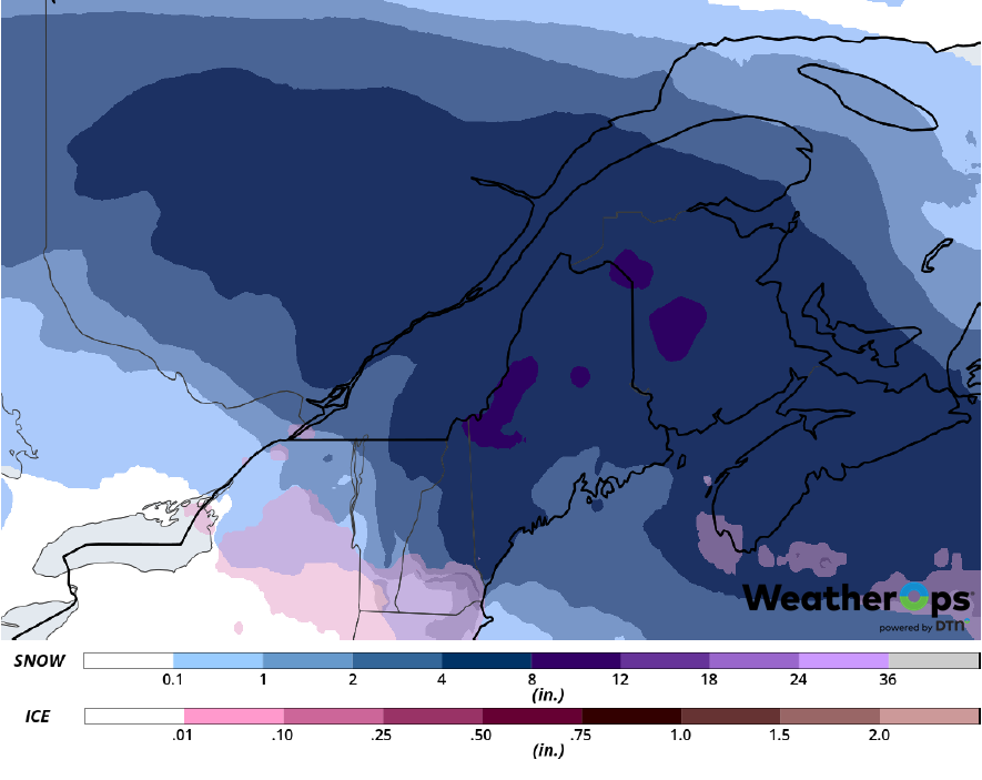
Snow Accumulation for Thursday
A Look Ahead
Freezing rain and snow are expected across the Northern Plains and Midwest on Friday as an area of low pressure moves eastward. This activity may continue into Saturday. Showers and thunderstorms are forecast Saturday across the Mid-Mississippi Valley. By Sunday, heavy snow may develop across the Great Lakes. Light snow is expected across the Northeast on Monday.
