National Weather Summary for Tuesday, August 16, 2016
by David Moran, on Aug 16, 2016 11:47:22 AM
Thunderstorms will be possible on Tuesday across portions of the Midwest as a result of daytime heating. Across the Ohio Valley and Northeast, thunderstorms will be possible as an area of low pressure tracks through the region. Heavy rain will continue across portions of eastern Texas and the Lower Mississippi Valley along a stalled front. Into Wednesday, the stalled front will continue to be a focus for heavy rain across portions of Central Texas. A cold front will be the focus for thunderstorm development across portions of the Mid Atlantic. Across the Northern Plains, a cold front will be the focal point for thunderstorm development on Thursday.
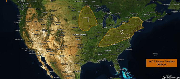
US Hazards
Region 1
As an upper level disturbance makes its way across northern portions of the Midwest today, ample moisture as well as strong instability will remain prevalent across Region 1 today. This will result in an increase in thunderstorm coverage and intensity as the afternoon and evening progress. Most of these thunderstorms are forecast to be linear in nature, however a few supercells will also be possible. The primary threats with any thunderstorm that does develop will be large hail and damaging winds.
Major Cities in Region: Sioux Falls, SD, Omaha, NE, Minneapolis, MN, Des Moines, IA
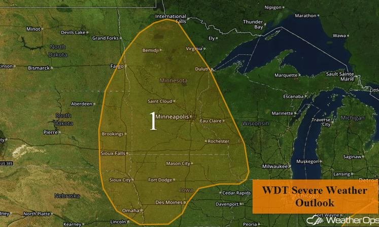
Region 1
Region 2
An area of low pressure is forecast to lift across the Northeast today and into tonight with its associated warm front currently stretching from New Jersey westward into southern Michigan. This warm front will lift northeastward toward New England by tonight. As this warm front continues to lift across the region, warm moist air will spread over much of the Northeast. Combined with day time heating, instability will build during the afternoon and evening hours across portions of the Northeast and Ohio Valley. The associated cold front currently stretches from southern Michigan southwestward into Indiana and Northeastern Arkansas. As this front continues eastward, moderate to strong instability combined with moderate to strong wind shear across much of the Northeast and Ohio Valley will lead to an increase in thunderstorm coverage and intensity this afternoon and evening. Given the high shear values across the Northeast, there will be a combination of supercells and linear thunderstorms across the region, especially during the afternoon hours with a transition to mostly linear thunderstorms by the evening hours. All severe weather threats will be possible with these thunderstorms; damaging winds and a few tornadoes, as well as large hail. Further to the southwest in the Ohio Valley, thunderstorms are forecast to be more linear in nature and are expected to pose a primarily damaging wind threat, but some isolated areas of large hail will be possible.
Update 2:53pm EDT: Severe thunderstorms capable of hail and damaging winds moving through portions of Maryland.
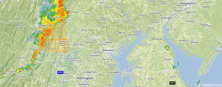
Radar 2:53pm EDT
Major Cities in Region: Cincinnati, OH, Charleston, WV, Pittsburgh, PA, Washington, DC, Philadelphia, PA, New York, NY, Boston, MA
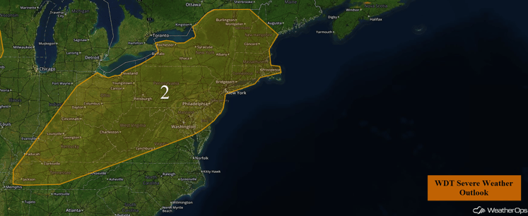
Region 2
Excessive Rainfall Possible Tuesday across East Texas and the Lower Mississippi Valley
The threat for excessive rainfall will persist along a stalled front across the Ozarks into east Texas. Ongoing showers and thunderstorms will persist for much of the day into the evening, with the heaviest rainfall expected to be during the afternoon hours with strong thunderstorms. Rainfall totals of 1-3 inches with locally higher amounts in excess of 4 inches will be possible.
Major Cities in Region: San Antonio, TX, Houston, TX, Shreveport, LA, Little Rock, AR
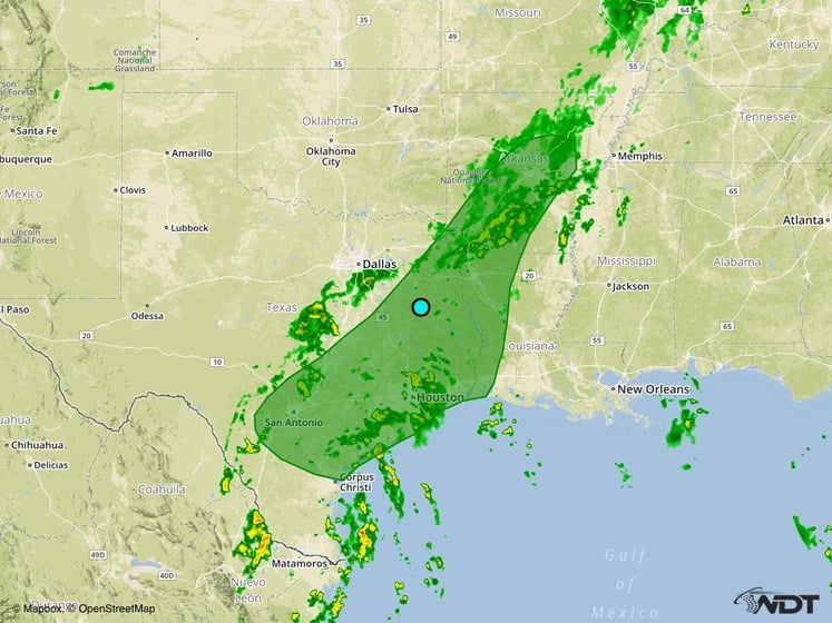
Excessive Rainfall Risk Outline
Excessive Rainfall Possible for Portions of Central Texas on Wednesday
Excessive rainfall will continue across Central Texas on Wednesday. Showers and thunderstorms will be possible for most of the day and evening along a stalled front. Some of this activity may contain high rainfall rates due to the ample moisture in place. Rainfall totals of 1-2 inches with locally higher amounts in excess of 3 inches will be possible.
Major Cities in Region: San Antonio, TX, Austin, TX, Waco, TX
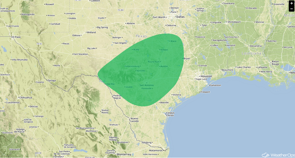
Excessive Rainfall Risk Outline for Wednesday
Strong to Severe Thunderstorms Possible for Mid Atlantic on Wednesday
There will be a low chance for severe thunderstorms across portions of the Mid Atlantic on Wednesday. Thunderstorms are expected to develop as a cold front progresses southward during the afternoon hours. Conditions will not be overly favorable for the development of thunderstorms, however, some thunderstorms could be severe could become strong to severe. Primary hazard will be damaging winds.
Major Cities in Region: Raleigh, NC, Washington, DC, Baltimore, MD, Philadelphia, PA
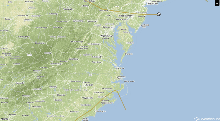
SPC Convective Outlook for Wednesday
Strong to Severe Thunderstorms Possible Thursday across the Northern Plains
The threat for severe weather will return to the Northern Plains on Wednesday as a cold front moves into the region from Canada. Showers and thunderstorms are expected to develop during the early afternoon hours and increase in coverage and intensity into the late evening. Primary hazards with this activity will be large hail, damaging winds, and a couple tornadoes.
Major Cities in Region: Aberdeen, SD, Fargo, ND, Minneapolis, MN
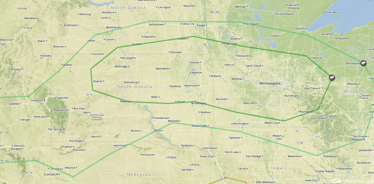
SPC Convective Outlook for Thursday
This is just a brief look at current weather hazards. We can provide you site-specific forecast information for the purpose of protecting your personnel and assets. Try a 7-day demo right away and learn how timely precision weather information can enhance your bottom line.


