National Weather Summary for Tuesday, August 15, 2017
by David Moran, on Aug 15, 2017 10:46:55 AM
There will be a risk for thunderstorms and excessive rainfall across the Great Plains on Tuesday as a shortwave trough moves over the Northern Plains. A cold front moving through the Northeast will be the focus for the development of thunderstorms on Tuesday.
- Thunderstorms across the Great Plains on Tuesday
- Risk for Thunderstorms Tuesday across the Northeast
- Thunderstorm Potential across the Central Plains and into the Missouri Valley on Wednesday
- Thunderstorms Thursday for the Great Lakes and Ohio Valley
- Potential for Thunderstorms across the Southern High Plains on Thursday
- Tropical Update
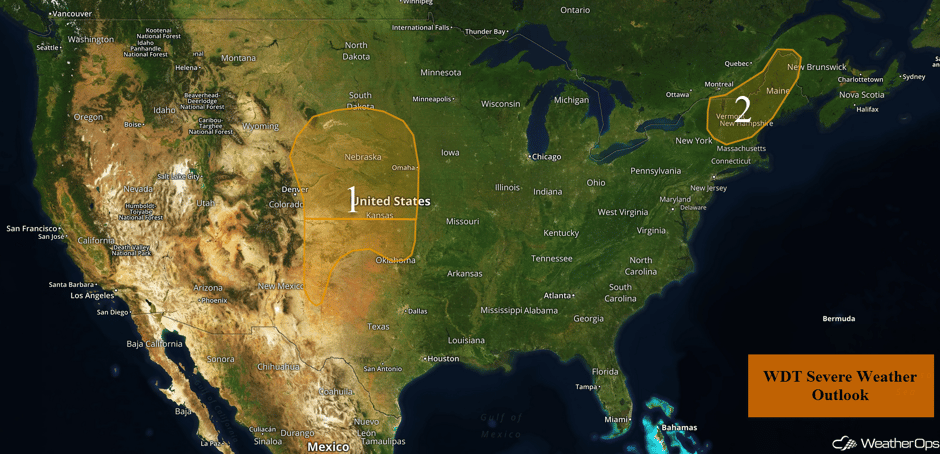 US Hazards
Thunderstorms across the Great Plains on Tuesday
Scattered thunderstorms are expected to develop across portions of the Central Plains on Tuesday during the mid to late afternoon. Thunderstorms are forecast to quickly evolve into clusters of thunderstorms, and eventually a line. These storms will move to the east-southeast and southeast with a potential for strong winds and large hail.
Update 1:02pm CDT: Severe thunderstorms capable of hail and damaging winds developing across Nebraska.
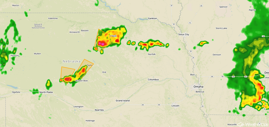 Radar 1:02pm CDT
Major Cities in Region: Cheyenne, WY, North Platte, NE, Pierre, SD, Wichita, KS, Sioux Falls, SD, Omaha, NE
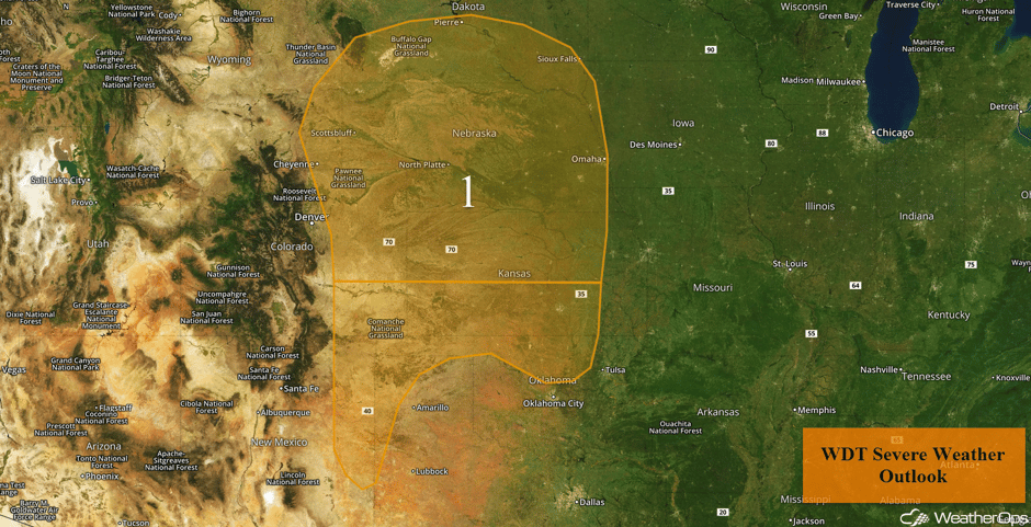 Region 1
Risk for Thunderstorms Tuesday across the Northeast
A cold front progressing through the Northeast today, increasing moisture and temperatures, will lead to the development of thunderstorms along the front. Some storms may become strong to severe due to an upper level trough moving through the region. As a result, strong winds and large hail may develop within the strongest storms.
Major Cities in Region: Burlington, VT, Concord, NH, Augusta, ME
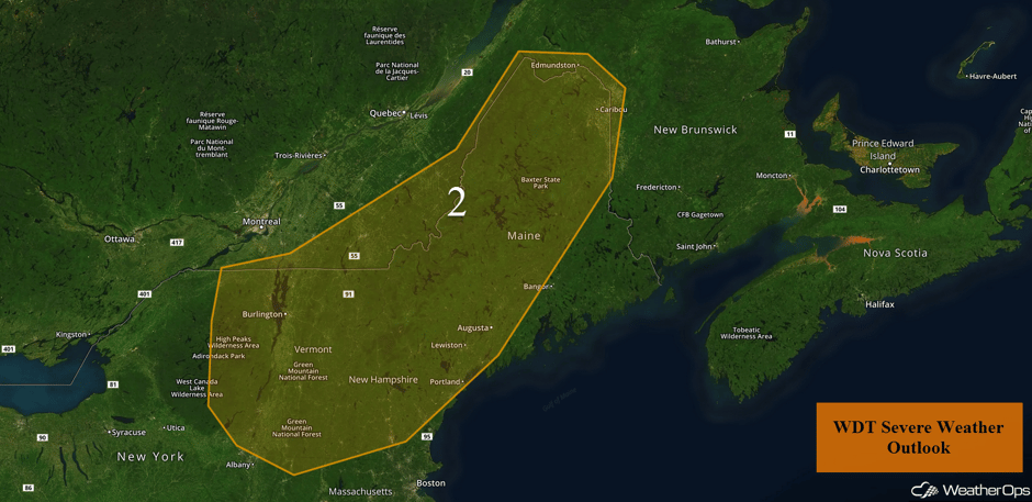 Region 2
Thunderstorm Potential across the Central Plains and into the Missouri Valley on Wednesday
An area of low pressure will move northeastward into the Northern Plains and bring the threat for strong to severe thunderstorms on Wednesday. Thunderstorm activity may be ongoing during the morning, which may limit the severe threat later in the day. Once the morning storms clear, southerly winds and daytime heating will destabilize the atmosphere. Thunderstorms should develop during the late afternoon. Strong to severe winds and hail will be the primary hazards.
In addition, heavy to excessive rainfall is forecast across the region. Rainfall amounts of 1-2 inches with locally heavier amounts are expected. Flooding and flash flooding will also be potential hazards.
Major Cities in Region: Oklahoma City, OK, Omaha, NE, Kansas City, MO, Des Moines, IA, Minneapolis, MN
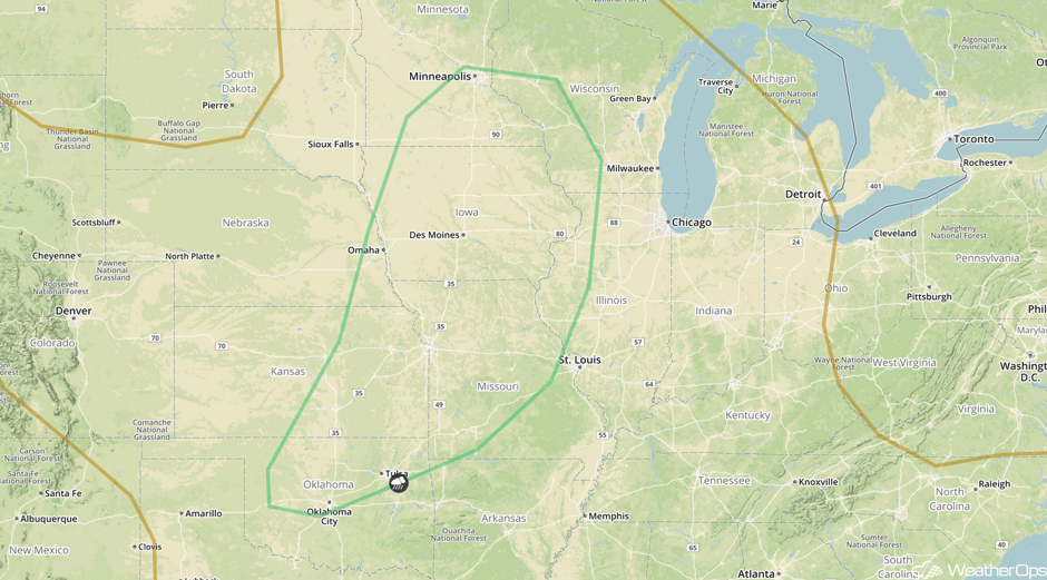 SPC Convective Outlook for Wednesday
Thunderstorms Thursday for the Great Lakes and Ohio Valley
An area of low pressure will continue to move northeastward into the Great Lakes on Wednesday and bring a risk of strong to severe thunderstorms. Morning thunderstorms may affect the potential for thunderstorms later in the day. Southerly winds pulling in warm, moist air should destabilize the atmosphere allowing for the development of thunderstorms. Clusters of thunderstorms should develop but the severe potential will be limited. Strong winds, frequent lightning, and heavy rainfall will be the primary hazards.
Major Cities in Region: Evansville, IN, Indianapolis, IN, Louisville, KY, Cincinnati, OH, Detroit, MI, Cleveland, OH
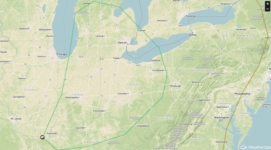 SPC Convective Outlook for Thursday
Potential for Thunderstorms across the Southern High Plains on Thursday
A shortwave trough will move across Colorado and Wyoming on Thursday and bring a risk for showers and thunderstorms across the Southern High Plains. A surface disturbance is forecast to develop along the New Mexico and Texas border, providing a source of lift. Warm temperatures and cool mid-level temperatures will allow instability to build. In addition, vertical wind shear will allow for organized development, including a few isolated supercells. Strong to severe wind gusts, large hail, and isolated tornadoes will all be potential hazards.
In addition, heavy rainfall is expected. Rainfall amounts of 0.5-1.0 inch with locally higher amounts are forecast.
Major Cities in Region: Trinidad, CO, Amarillo, TX, Guymon, OK
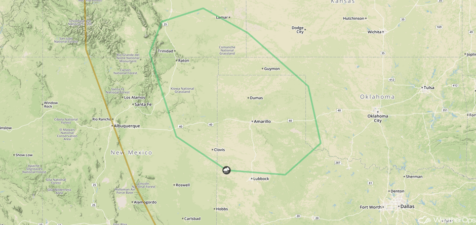 SPC Convective Outlook for Thursday
Tropical Update
Hurricane Gert (green oval) is moving toward the north-northeast at 10 mph. A gradual turn toward the northeast with an increase in forward speed is expected through the next couple of days. Maximum sustained winds are near 75 mph with higher gusts. Some strengthening is expected over the next day or two.
An elongated area of low pressure (red oval) more than a thousand miles east of the Lesser Antilles is producing disorganized showers and thunderstorms. This system is expected to move westward at 15-20 mph, crossing into the Caribbean Sea on Friday. Environmental conditions appear supportive of tropical cyclone development over the next few days but should become less favorable as it moves into the Caribbean.
A second area of low pressure (blue oval) associated with a tropical wave is also producing disorganized shower and thunderstorm activity a few hundred miles west-southwest of the Cabo Verde Islands. Some development may occur over the next few days as the system moves west-northwestward.
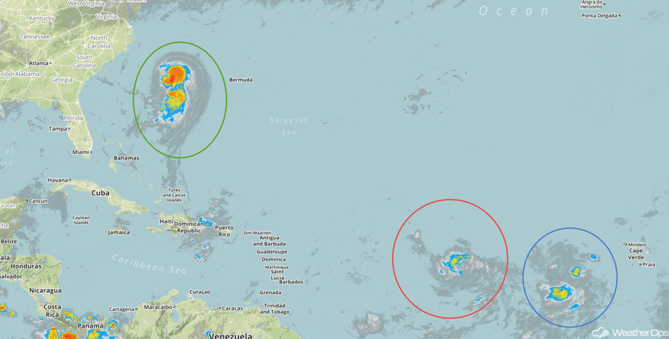 Tropical Enhanced Infrared Satellite
A Look Ahead
Showers and thunderstorms may develop across the Northeast and Mid Atlantic on Friday as a cold front moves across the region. A stalled front may allow for a few showers and thunderstorms across the Southeast. Continued showers and thunderstorms are expected across the Northeast on Saturday. By Sunday and Monday, showers and thunderstorms will develop across the Mid Atlantic and Southeast along a stalled point. By Monday, an area of low pressure will likely develop over the Northern Plains, bringing a chance for showers and thunderstorms.
This is just a brief look at current weather hazards. We can provide you site-specific weather forecast information for the purpose of protecting your personnel and assets and to assess your weather risk. Try a 7-day demo right away and learn how timely precision weather information can enhance your bottom line.


