National Weather Summary for Tuesday, April 11, 2017
by David Moran, on Apr 11, 2017 11:13:18 AM
Thunderstorms may develop for portions of Texas as instability builds through the day. A cold front moving through the Northeast will be the focus for thunderstorm development on Tuesday. An upper level trough moving through the Southwest will allow for some thunderstorms across portions of New Mexico Tuesday afternoon.
- Additional Thunderstorms Tuesday across Texas
- Strong to Severe Thunderstorms Possible for the Northeast Tuesday
- Potential for Thunderstorms across New Mexico on Tuesday
- Thunderstorm Development Across the Central and Southern Plains on Wednesday
- Strong to Severe Thunderstorms Thursday for Portions of New Mexico and West Texas
- Excessive Rainfall Potential for northwestern Texas and western Oklahoma on Thursday
Region 1
Strong to severe thunderstorms will continue throughout the day over portions of South Texas into the Texas Gulf Coast. A large area of ongoing thunderstorms over central Texas this morning and will slowly shift southeastward toward the Texas coast during the day and evening, producing a threat for strong winds. Additional development of thunderstorms may be possible over South Texas during the afternoon. Large hail and damaging winds will be the primary hazards.
Update 11:52am CDT: Severe thunderstorm capable of large hail north of San Antonio, TX.
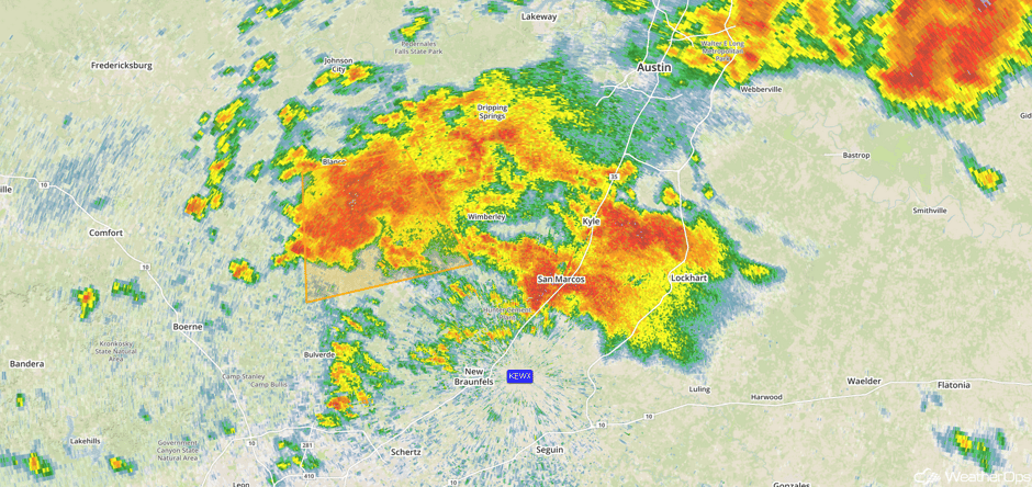 Radar 11:52am CDT
Update 12:45pm CDT: Flash flooding likely near San Marcos, TX.
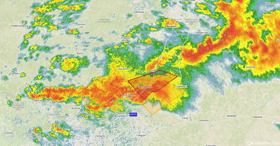 Radar 12:45pm CDT
Update 1:03pm CDT: Tornado Warning south of San Marcos, TX.
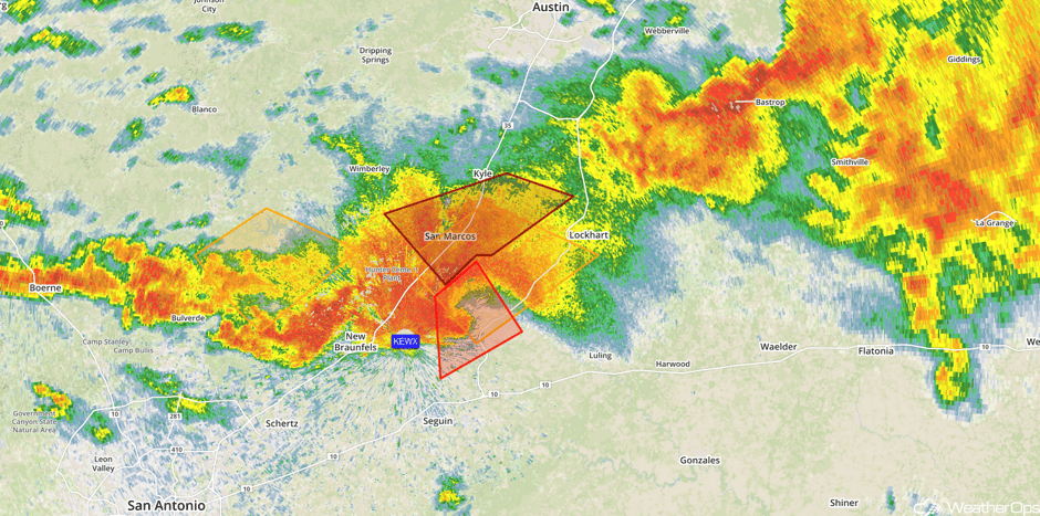 Radar 1:03pm CDT
Major Cities in Region: Laredo, TX, San Antonio, TX, Austin, TX, Corpus Christi, TX, Houston, TX, Beaumont, TX
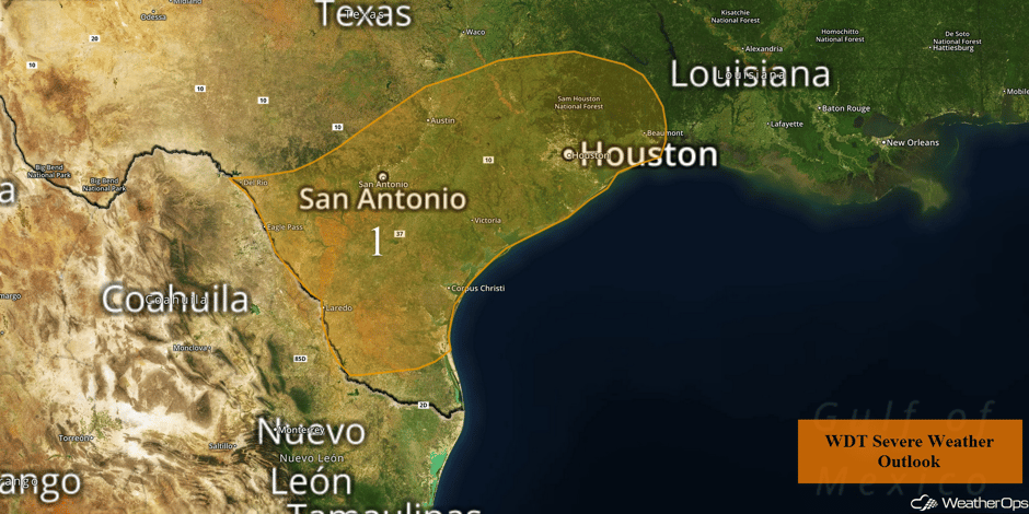 Region 1
Region 2
Scattered to widespread thunderstorms, some of which may be strong, are expected to develop across Region 2 on Tuesday. A cold front associated with an area of low pressure over Quebec will track through the region today, with thunderstorms developing ahead of the front. Damaging winds will be the primary hazard with any of these storms. The threat should diminish during the early evening.
Major Cities in Region: Pittsburgh, PA, Syracuse, NY, Albany, NY
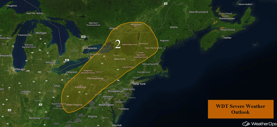 Region 2
Potential for Thunderstorms across New Mexico on Tuesday
Southeasterly flow is forecast to develop during the evening which should allow for moisture return to the region. With an upper level trough approaching the region, combined with the southeasterly flow at the surface, some lift will be present resulting in isolated thunderstorms over the region into the evening. Large hail and strong wind gusts will be the primary hazards with these storms.
Major Cities in Region Las Cruces, NM, Alamogordo, NM, Roswell, NM
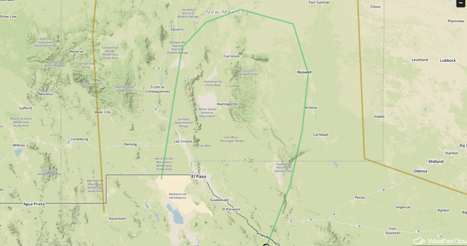 SPC Convective Outlook for Tuesday
Thunderstorm Development Across the Central and Southern Plains on Wednesday
Widely isolated thunderstorms are possible across the Central and Southern Plains on Wednesday. An area of low pressure is forecast to develop with southerly to southeasterly flow to the east of the low, bringing moisture into the region. Instability is forecast to build across the Central Plains with the potential for enough instability for thunderstorm development. Isolated thunderstorms are expected from the Oklahoma Panhandle northward. Further south into New Mexico and west Texas, thunderstorms are expected to be more widespread. Thunderstorms may evolve into a large complex by late evening and into the overnight hours with gusty winds as the primary hazard.
Major Cities in Region: Odessa, TX, Lubbock, TX, Amarillo, TX, Dodge City, KS, Goodland, KS, Grand Island, NE
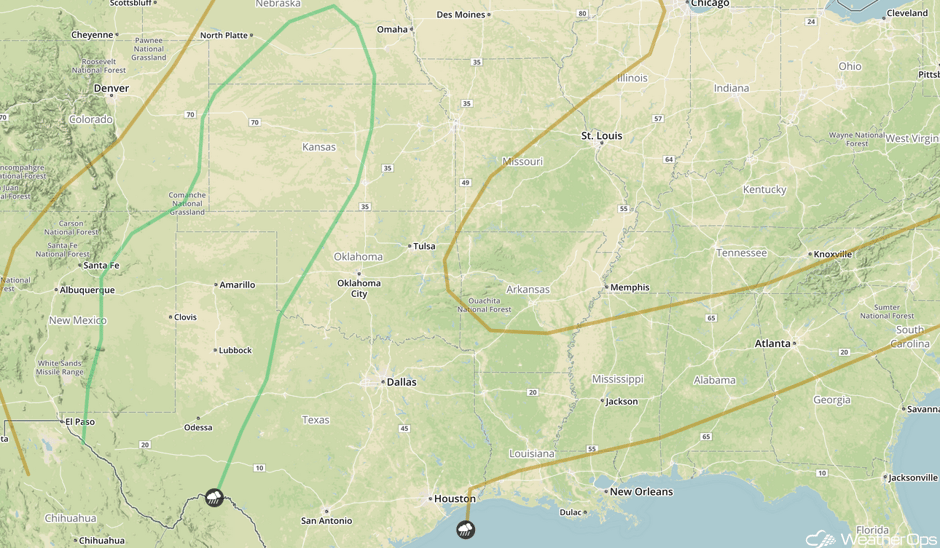 SPC Convective Outlook for Wednesday
Strong to Severe Thunderstorms Thursday for Portions of New Mexico and West Texas
Southerly winds over the region will bring moisture into the region. This, coupled with increasing temperatures, will increase instability. Aloft, an upper level trough is forecast to pass over the Southern Plains, providing upper level support for the development of strong to severe thunderstorms. Large hail and strong winds will be the primary hazard with any thunderstorms that develop.
Major Cities in Region: Roswell, NM, Carlsbad, NM
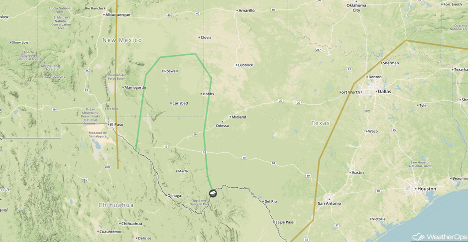 SPC Convective Outlook for Thursday
Excessive Rainfall Potential for northwestern Texas and western Oklahoma on Thursday
Ongoing shower and thunderstorm activity from Wednesday is forecast to move over northwestern Texas and western Oklahoma on Thursday, bringing widespread rainfall to the region. As a result, heavy to potentially excessive rainfall will be possible over the region. Rainfall amounts of 0.5-1.0 inch with isolated higher amounts in excess of 2 inches are forecast.
Major Cities in Region: Altus, OK, Woodward, OK
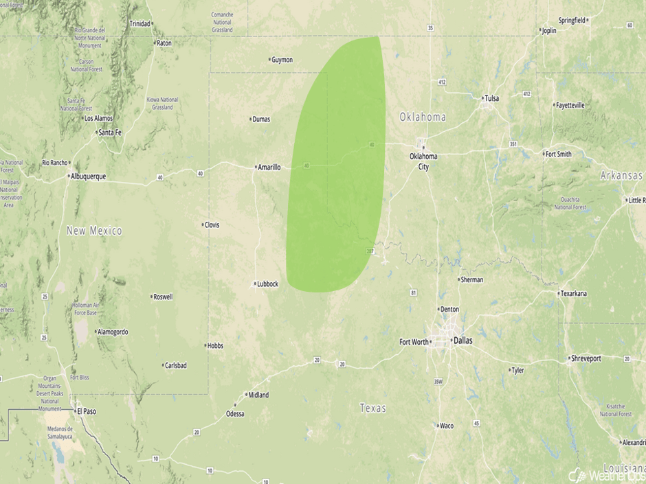 Excessive Rainfall Risk Outline for Thursday
A Look Ahead
An upper level trough moving over the northern Rockies on Friday will provide the upper level support for the development of strong to severe thunderstorms across portions of the Plains. Into Saturday, thunderstorms may develop across northwestern Oklahoma and Kansas as a cold front and dry line move eastward.
This is just a brief look at current weather hazards. We can provide you site-specific weather forecast information for the purpose of protecting your personnel and assets and to assess your weather risk. Try a 7-day demo right away and learn how timely precision weather information can enhance your bottom line.


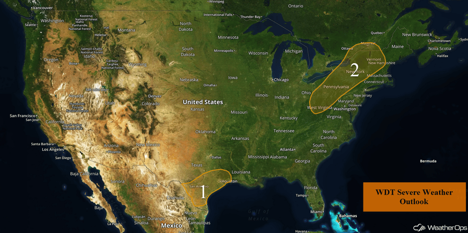 US Hazards

