National Weather Summary for Thursday, October 27, 2016
by David Moran, on Oct 27, 2016 9:54:00 AM
No hazards are currently in effect. Excessive rainfall will be possible for portions of California today through Saturday as an area of low pressure develops off the West Coast.

US Hazards
Excessive Rainfall Possible for Portions of California through Saturday
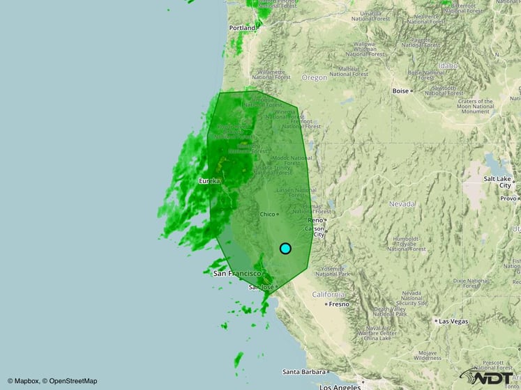
An area of low pressure is developing off the coast of California. Along with a second area of low pressure over Oregon, heavy to excessive rainfall will be possible for portions of northern California through Saturday. Three day rainfall totals of 5-7 inches with isolated higher amounts of 9 inches will be possible.
Major Cities in Region: Eureka, CA, Chico, CA, San Francisco, CA, San Jose, CA

Excessive Rainfall Risk Outline for Thursday through Saturday
Tropical Update
No tropical activity is expected over the next 48 hours.
A Look Ahead
Some light rain will be possible across portions of the Ohio Valley on Sunday along a stalled front. Further west, some light to moderate rain and snow showers in the upper elevations of the Northern Rockies. On Tuesday, an area of low pressure will move across the Great Lakes. By Wednesday, an area of low pressure will develop over Colorado, Southerly flow to the east of the low may allow for the development of showers and thunderstorms across portions of the Southern Plains.
This is just a brief look at current weather hazards. We can provide you site-specific forecast information for the purpose of protecting your personnel and assets. Try a 7-day demo right away and learn how timely precision weather information can enhance your bottom line.


