


by David Moran, on May 31, 2018 11:30:36 AM
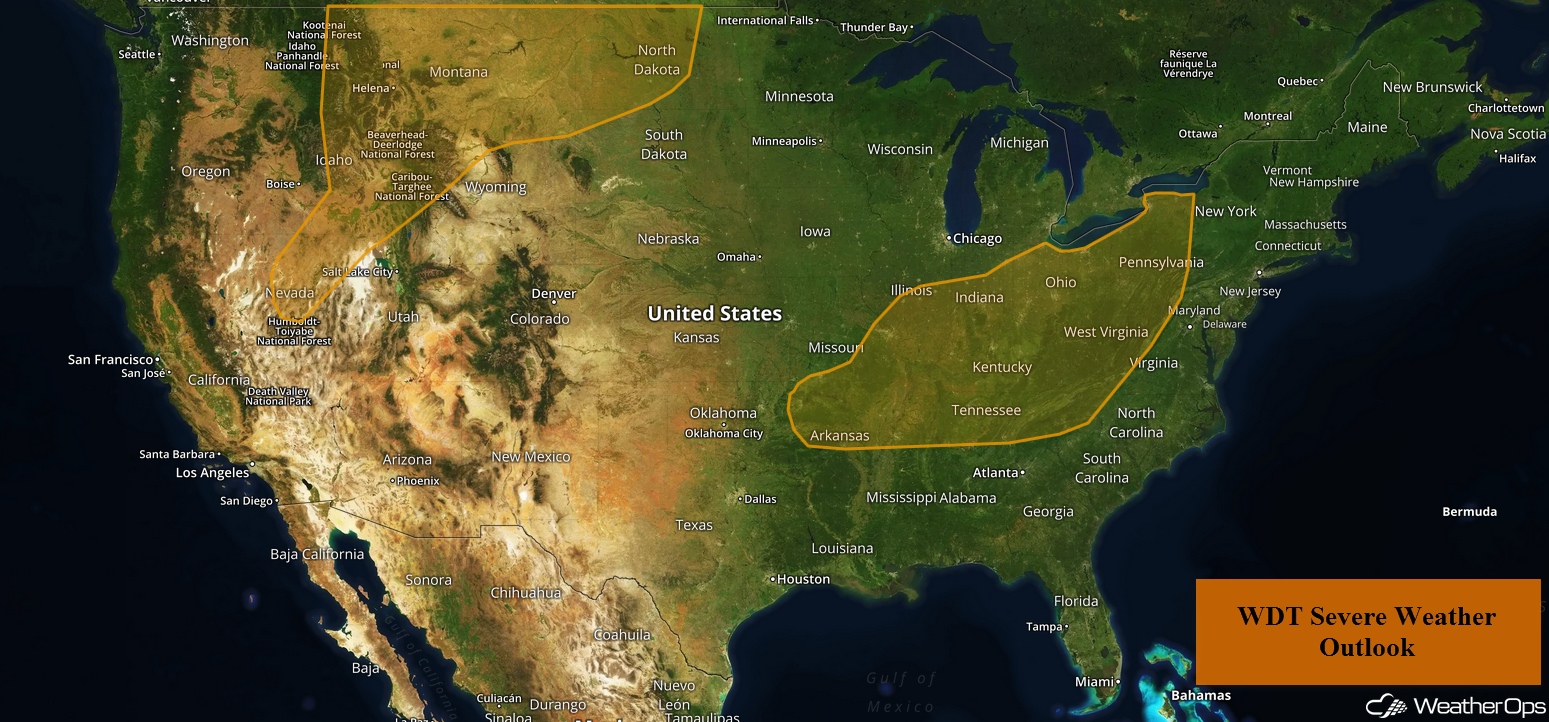
Thunderstorms are forecast across the Northern Rockies and Northern High Plains on Thursday in association with an area of low pressure. Remnants from overnight storms from the Ozarks into the Tennessee Valley will re-intensify during the day. Excessive rainfall is expected across portions of Montana as showers and thunderstorms develop. As a complex of storms moves eastward, there will be the potential for excessive rainfall across the Midwest. Rainfall will continue across portions of the Appalachians, leading to a potential for flash flooding.
- Thunderstorms for the Northern Rockies and Northern High Plains on Thursday
- Excessive Rainfall Thursday across Montana
- Thunderstorm Potential from the Ozarks into the Tennessee Valley Thursday
- Risk for Excessive Rainfall Thursday across the Midwest
- Excessive Rainfall for the Appalachians on Thursday
- Thunderstorms Friday for the Northern Plains
- Excessive Rainfall across the Northern Plains on Friday
- Potential for Thunderstorms Friday across West Texas
- Thunderstorms from the Mid Mississippi Valley into the Mid Atlantic Friday
- Excessive Rainfall Friday from the Tennessee Valley into the Mid Atlantic
- Thunderstorm Potential across the Midwest on Saturday
- Risk for Excessive Rainfall Saturday across the Midwest
- Excessive Rainfall for the Mid Atlantic on Saturday
 US Hazards

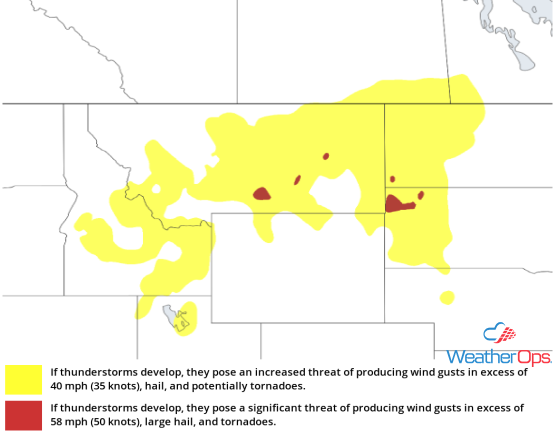
Thunderstorms for the Northern Rockies and Northern High Plains on Thursday
Daytime heating and ample moisture will destabilize the atmosphere by the early afternoon hours. A slow-moving area of low pressure will make its way across the region as the day progresses. This will become the focus for thunderstorm development by the late afternoon to early evening hours. Due to the instability across the region, these storms will intensify rapidly. Initially, storms will be scattered in nature, bringing with them the potential for severe wind, large hail, and an isolated tornado or two. As the evening progresses, they will become linear in nature and the primary hazard will transition to a severe wind threat. These storms should weaken some after sunset when daytime heating is lost, but the severe threat will continue into the overnight hours.
Major Cities in Region: Pocatello, ID, Idaho Falls, ID, Butte, MT, Helena, MT, Billings, MT, Glendive, MT, Minot, ND
 Thunderstorm Risk for Thursday
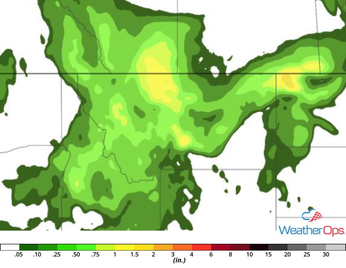
Excessive Rainfall Thursday across Montana
A disturbance will continue to strengthen across the region on Thursday. With above-normal moisture in place, moderate to heavy rainfall is expected. Scattered showers and thunderstorms will develop along a frontal boundary located along the eastern slopes of the Rocky Mountains, bringing widespread rainfall amounts from 1-2 inches across the region. Locally higher amounts in excess of 2.5 inches are possible. Wet soil across the region will promote isolated flooding due to runoff.
Major Cities in Region: Butte, MT, Helena, MT, Billings, MT, Glendive, MT
 Rainfall Accumulation for Thursday
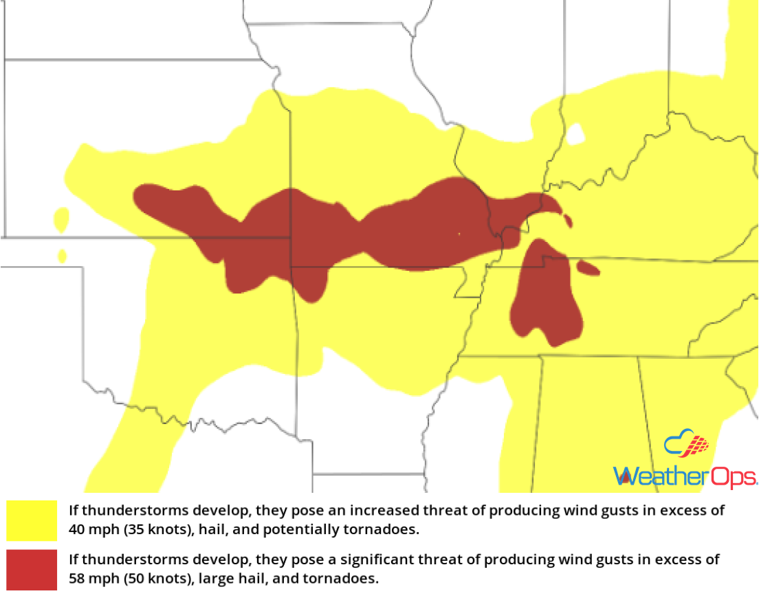
Thunderstorm Potential from the Ozarks into the Tennessee Valley Thursday
The remnants from overnight thunderstorms are continuing to push eastward. Daytime heating, as well as ample moisture across the region, will destabilize the atmosphere ahead of the existing showers and thunderstorms. This will allow them to intensify. These storms will start off scattered in nature, with large hail, damaging winds, and isolated tornadoes all potential hazards. As the day progresses, they will become linear in nature and the hail threat will decrease. The storms will continue to the east, weakening shortly after sunset when daytime heating is lost.
Major Cities in Region: Topeka, KS, Kansas City, MO, St. Louis, MO, Memphis, TN, Evansville, IN, Nashville, TN, Indianapolis, IN, Louisville, KY, Chattanooga, TN
 Thunderstorm Risk for Thursday
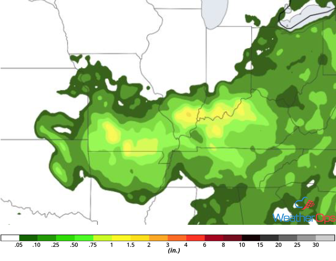
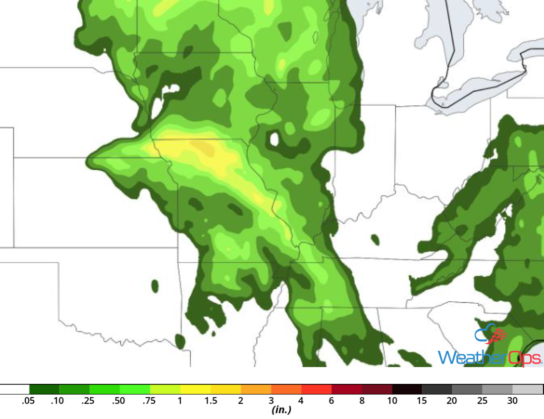
Risk for Excessive Rainfall Thursday across the Midwest
A developing complex of storms will continue to move eastward as the day progresses. Ample instability and moisture across the region will promote moderate to heavy rainfall, particularly in the afternoon to evening hours. Rainfall amounts ranging 1-2 inches are likely, with locally higher amounts in excess of 3 inches.
Major Cities in Region: Springfield, MO, Evansville, IN, Louisville, KY
 Rainfall Accumulation for Thursday
Excessive Rainfall for the Appalachians on Thursday
Abundant moisture will allow for the development of shower and thunderstorm activity by the late morning hours. Although this activity in itself does not pose a significant flooding threat, many areas across the region have received heavy rainfall in the past, resulting in saturated ground. This will allow any additional showers or thunderstorms to pose a flash flooding threat.
Major Cities in Region: Knoxville, TN, Charleston, WV, Asheville, NC
 Rainfall Accumulation for Thursday
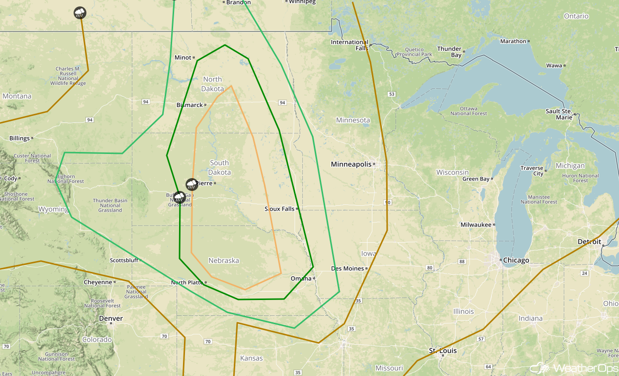
Thunderstorms Friday for the Northern Plains
A slow-moving area of low pressure is expected to move into the Northern Plains on Friday. Some morning shower and thunderstorm activity may develop but is not expected to be strong. That activity will dissipate by the early afternoon hours. Daytime heating and plentiful moisture across the region will allow for the destabilization of the atmosphere. Additional thunderstorm development is likely by the late afternoon hours in association with the area of low pressure. These storms will likely intensify rapidly, allowing for the threat for large hail, damaging winds, and an isolated tornado or two. Activity will become linear in nature as the evening progresses, diminishing the hail threat.
Major Cities in Region: North Platte, NE, Omaha, NE, Pierre, SD, Sioux Falls, SD, Bismarck, ND, Minot, ND, Fargo, ND
 SPC Convective Outlook for Friday
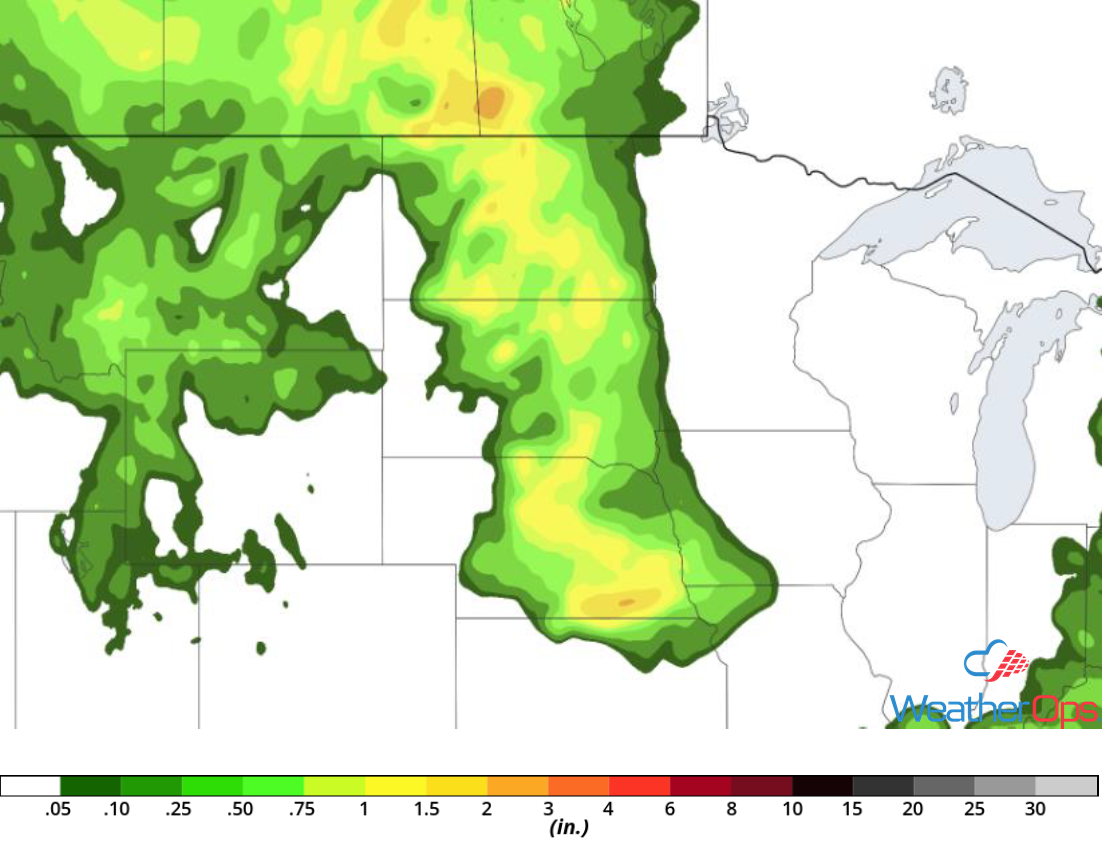
Excessive Rainfall across the Northern Plains on Friday
A disturbance is expected to track across the region from the west on Friday. Showers and thunderstorms are expected to develop by the early morning hours, which will weaken as they move off to the east. As the day progresses, instability will increase and a second round of showers and thunderstorms will develop. These will likely be more intense, bringing moderate to heavy rainfall. Storms will slowly move eastward, allowing rainfall amounts ranging 1-2 inches, with locally higher amounts in excess of 3 inches.
Major Cities in Region: Lincoln, NE, Omaha, NE, Sioux Falls, SD, Pierre, SD, Fargo, ND, Bismarck, ND
 Rainfall Accumulation for Friday
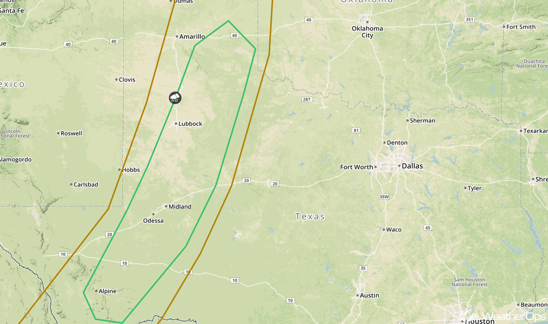
Potential for Thunderstorms Friday across West Texas
Daytime heating and sufficient moisture will allow for the destabilization of the atmosphere by the early afternoon hours. By the late afternoon to early evening hours, scattered thunderstorm development is likely along the dry line in West Texas. These storms will likely intensify quickly with large hail and severe wind being the primary hazards. They should dissipate shortly after sunset when daytime heating is lost.
Major Cities in Region: Odessa, TX, Midland, TX, Lubbock, TX
 SPC Convective Outlook for Friday
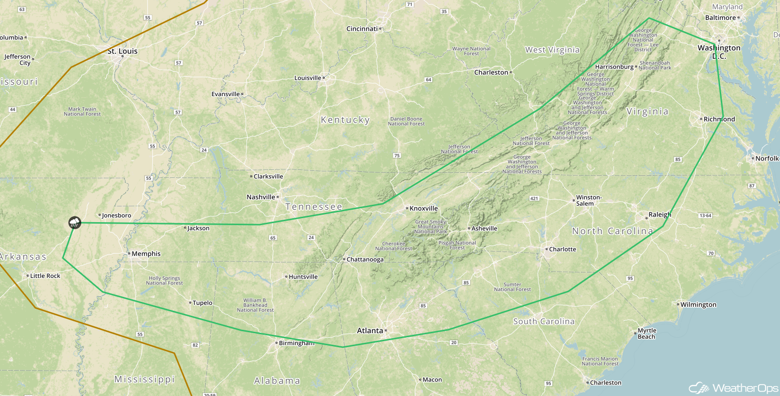
Rich moisture is forecast to be in place across the region; combined with daytime, heating instability will build through the afternoon. Scattered thunderstorms are expected to develop by the late afternoon. These storms will likely strengthen rapidly, producing a severe wind and a hail threat. They will become linear in nature as the evening progresses, and will weaken significantly after sunset when daytime instability is lost. Storms will likely dissipate overnight.
Major Cities in Region: Memphis, TN, Chattanooga, TN, Atlanta, GA, Charlotte, NC, Richmond, VA, Washington, DC
 SPC Convective Outlook for Friday
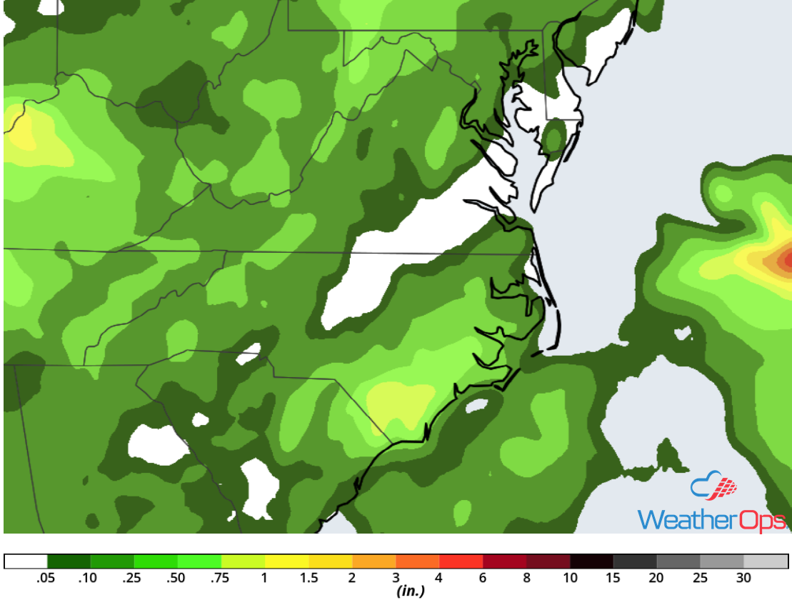
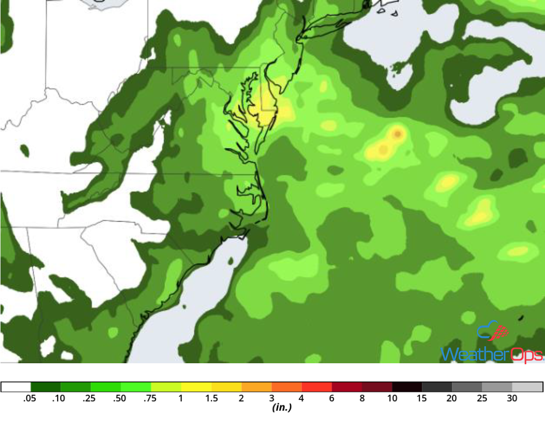
Excessive Rainfall Friday from the Tennessee Valley into the Mid Atlantic
Daytime heating and rich moisture will allow for the development of scattered thunderstorms along a frontal boundary. These storms will likely intensify quickly, producing moderate to heavy rainfall. The soil across this region is already saturated; therefore flooding is possible in areas that do see storms. Rainfall amounts from 1-2 inches are likely, with locally higher amounts in excess of 3 inches possible.
Major Cities in Region: Nashville, TN, Charleston, WV, Richmond, VA, Washington, DC
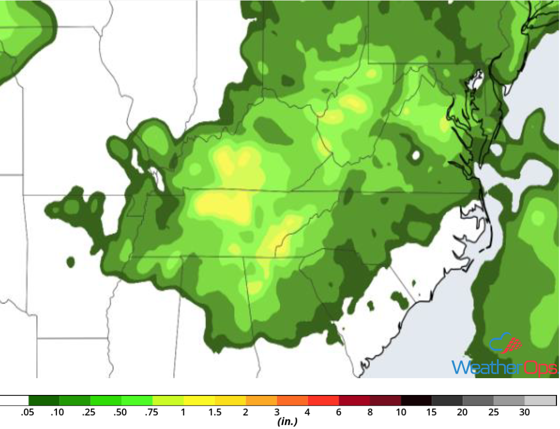 Rainfall Accumulation for Friday
Thunderstorm Potential across the Midwest on Saturday
The slow-moving area of low pressure that was over the Plains the last few days will increase in speed, reaching the Midwestern US on Saturday. Ongoing activity just to the west of the area will dissipate by the late morning hours. In the meantime, daytime heating and sufficient moisture will destabilize the atmosphere. By the late afternoon into the evening hours, thunderstorm development in association with the low is expected. Due to the unstable environment, these storms will strengthen quickly. Both a line of storms, as well as scattered thunderstorms, will develop with damaging winds and large hail being the primary hazards. A tornado or two cannot be ruled out.
Major Cities in Region: Des Moines, IA, Columbia, MO, St. Louis, MO, Springfield, IL
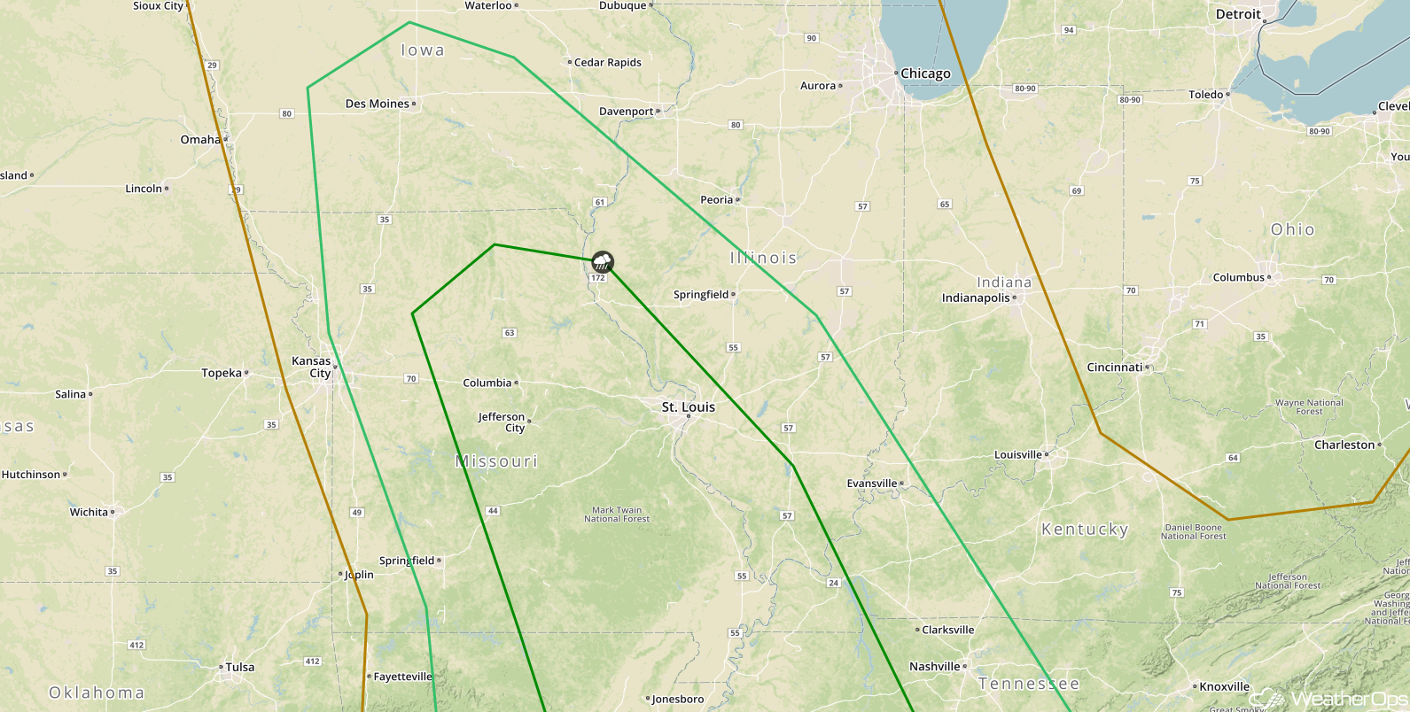 SPC Convective Outlook for Saturday
Risk for Excessive Rainfall Saturday across the Midwest
An area of low pressure will move through the Mississippi Valley on Saturday with widespread precipitation expected across the Midwest into the Mid-Mississippi Valley throughout the day. Showers and thunderstorms will become strong during the afternoon and evening hours. Within the heavier storms, rainfall accumulations in excess of 3 inches are expected. Otherwise, a large area of 1-2 inches is forecast before the rain moves off to the east early Sunday morning, allowing for a low risk of flooding.
Major Cities in Region: Kirksville, MO, Columbia, MO, St. Louis, MO
 Rainfall Accumulation for Saturday
Excessive Rainfall for the Mid Atlantic on Saturday
A slow moving area of low pressure will stall along the Mid-Atlantic coast on Saturday and will produce at least a low threat for excessive rainfall. Showers and thunderstorms will impact the region for much of the day and evening, some of which may contain high rainfall rates. Rainfall accumulations of 1-3 inches of rain are forecast through Saturday night. There will be a potential for minor flooding.
Major Cities in Region: Richmond, VA, Washington, DC, Baltimore, MD, Atlantic City, NJ
 Rainfall Accumulation for Saturday
A Look Ahead
Heading into Sunday, showers and thunderstorms will extend from the Great Lakes into the Southeast along a front. This activity will move into the Northeast and Mid Atlantic on Monday. Late Monday into Tuesday, thunderstorms may develop across portions of the Central and Southern Plains in association with an area of low pressure. Some light showers may develop across portions of the Northern Plains and Upper Midwest on Wednesday.
This is just a brief look at current weather hazards. We can provide you site-specific weather forecast information for the purpose of protecting your personnel and assets and to assess your weather risk. Try a 7-day demo right away and learn how timely precision weather information can enhance your bottom line.
