


by David Moran, on May 3, 2018 11:06:53 AM
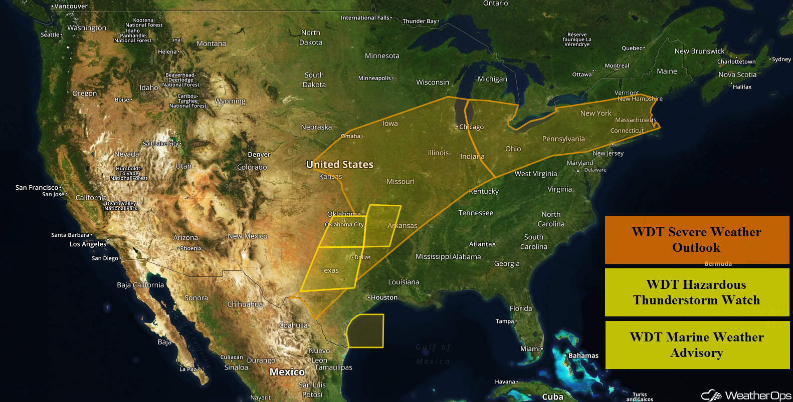
Thunderstorms are forecast from portions of Texas to the Great Lakes on Thursday in association with an upper level system. A front moving through the Northeast will be the focus for the development of storms. Excessive rainfall is forecast for portions of the Upper Mississippi Valley and Great Lakes as a warm front lifts northward. Thunderstorms moving through the Ozarks will bring a risk for excessive rainfall to the region.
- Thunderstorms from Texas into the Great Lakes on Thursday
- Potential for Thunderstorms Thursday across the Northeast
- Excessive Rainfall for the Upper Mississippi Valley and Great Lakes on Thursday
- Elevated Winds and Seas for the Western Gulf of Mexico through Early Thursday Evening
- Potential for Excessive Rainfall Thursday across the Ozarks
- Thunderstorms for South Texas on Friday
- Risk for Thunderstorms Friday from the Ohio Valley into Lower New England
- Excessive Rainfall for South Texas Friday
 US Hazards

Thunderstorms from Texas into the Great Lakes on Thursday
Severe weather will continue from portions of Texas northeastward to the Great Lakes on Thursday as a powerful upper-level system moves slowly over the region. The associated surface low will move into northeastern Kansas by the afternoon. A dryline will extend southward from the low, and a warm front to the northeast. By the afternoon hours, the dryline should extend through eastern Oklahoma into Texas. Warm moist air will continue to move into the region from the south and east, and should become highly unstable in the afternoon hours. Strong to severe thunderstorms are likely along the dryline, and in the area east of the low and along and south of the warm front. The strongest convection is expected from northeast Oklahoma into western Missouri as some of the stronger dryline storms move northeastward. All modes of severe weather will be possible, including damaging winds, large hail, and tornadoes.
Major Cities in Region: Dallas, TX, Tulsa, OK, Kansas City, MO, Columbia, MO, Chicago, IL, Detroit, MI, Cleveland, OH
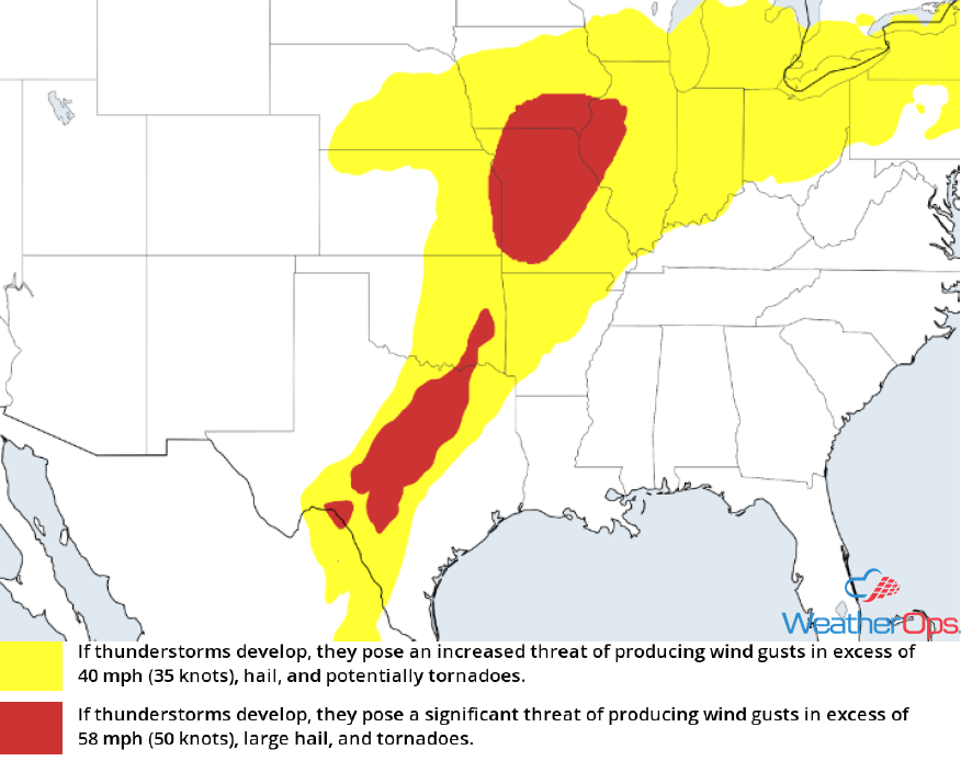 Thunderstorm Risk for Thursday
Potential for Thunderstorms Thursday across the Northeast
A frontal boundary across the region will serve as the focus for isolated to widely scattered strong to severe thunderstorms today. Daytime heating is expected to destabilize the atmosphere enough for storm formation, primarily in the afternoon hours. The primary threat will be isolated instances of severe wind gusts. Storm severity is expected to diminish in the evening hours with the loss of daytime heating.
Major Cities in Region: Buffalo, NY, Albany, NY, New York, NY, Boston, MA
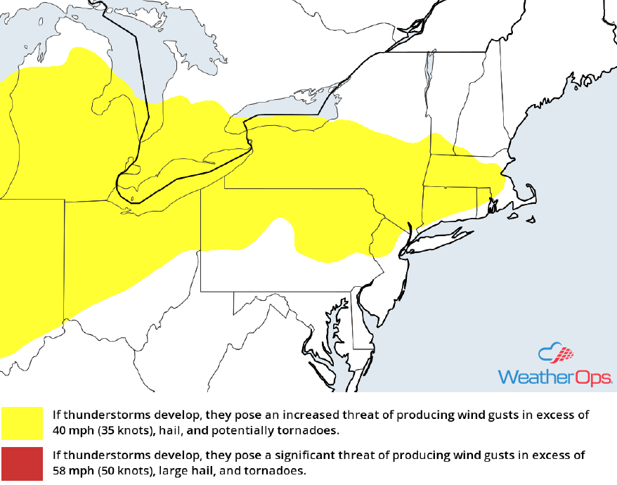 Thunderstorm Risk for Thursday
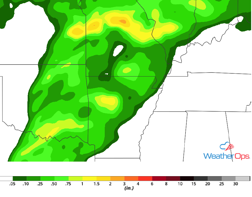
Excessive Rainfall for the Upper Mississippi Valley and Great Lakes on Thursday
A warm front will extend to the northeast from a surface low in eastern Kansas today, and widespread thunderstorm activity is expected along and near the front. Storms are currently ongoing and more are expected to develop in the afternoon. Some locations are expected to receive 1-2 inches of rain, with local amounts in excess of 3 inches possible.
Major Cities in Region: Cedar Rapids, IA, Milwaukee, WI, Lansing, MI
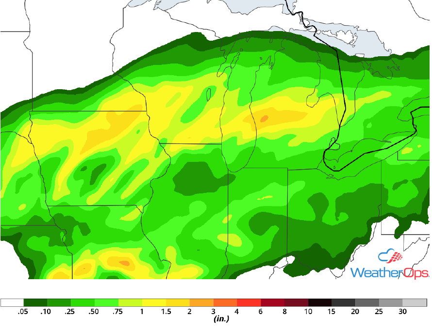 Rainfall Accumulation for Thursday
Elevated Winds and Seas for the Western Gulf of Mexico through Early Thursday Evening
An area of low pressure located over the central Plains will keep slightly elevated southeasterly winds present across the western Gulf of Mexico through early evening. In addition, significant wave heights up to 7 feet are expected. Conditions will begin to improve from east to west as the area of low pressure lifts northeastward across the central US.
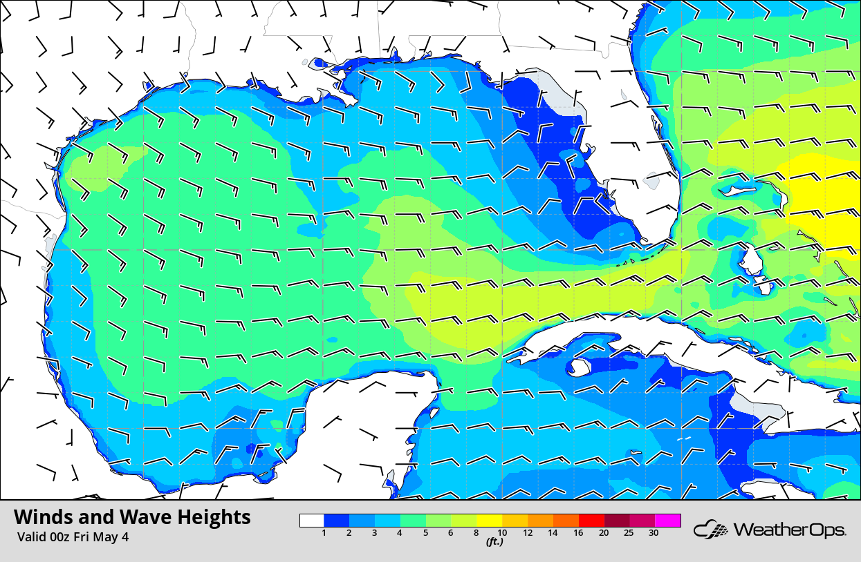 Winds and Wave Heights 7pm CDT Thursday
Potential for Excessive Rainfall Thursday across the Ozarks
Showers and thunderstorms that developed to the southwest of the region will continue to move northeastward. Additional thunderstorm activity is expected to develop across the region this afternoon. Rainfall amounts of 1-2 inches are with locally higher amounts in excess of 3 inches are forecast.
Major Cities in Region: Columbia, MO, St. Louis, MO
 Rainfall Accumulation for Thursday
Thunderstorms For South Texas on Friday
A slow moving cold front and upper level wave will move across South Texas on Friday. With increasing moisture and lift generated by the front, isolated to scattered thunderstorms are expected to develop. Damaging winds and large hail will be the primary hazards with these storms.
Major Cities in Region: Del Rio, TX, San Antonio, TX, Austin, TX, Waco, TX, Tyler, TX
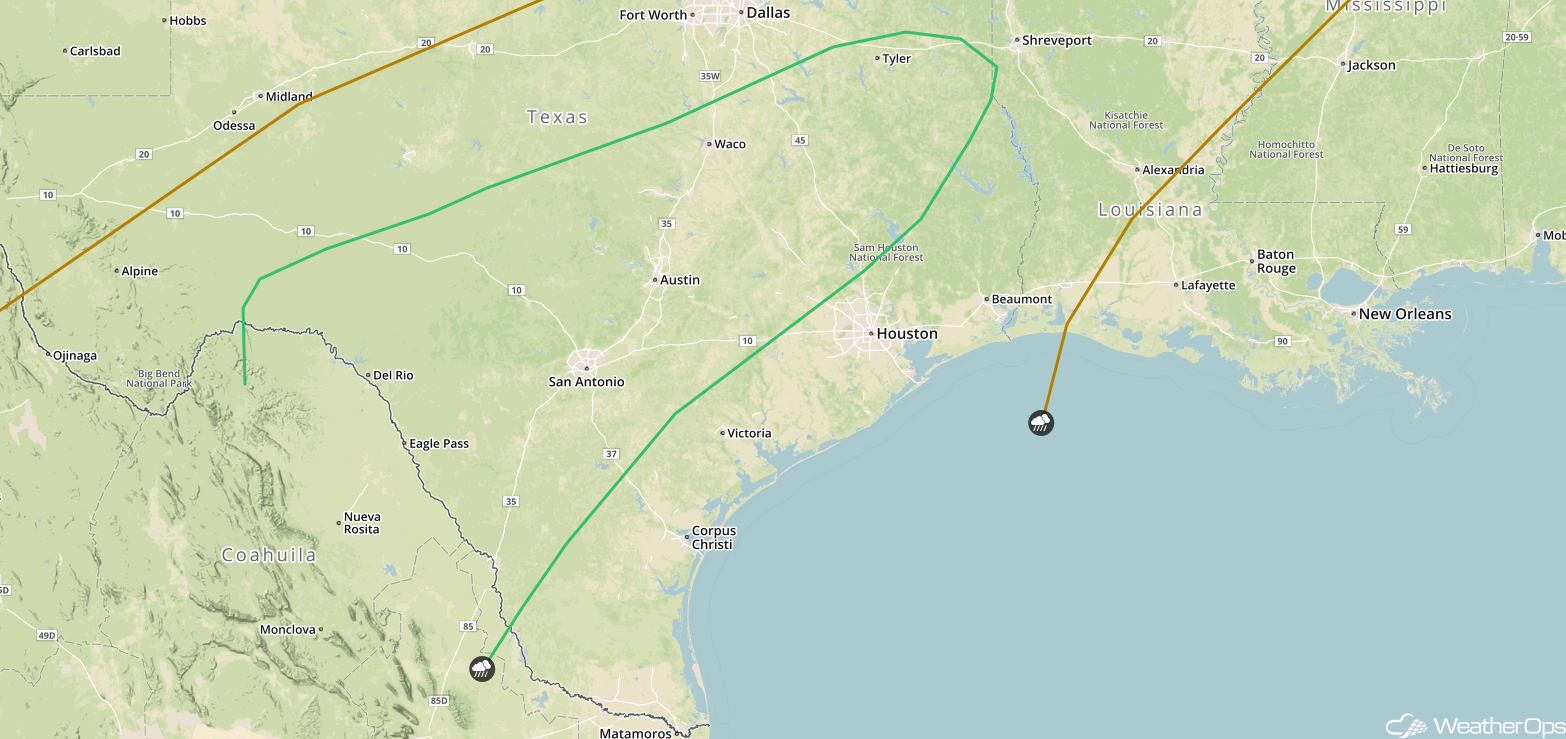 SPC Convective Outlook for Friday
Risk for Thunderstorms Friday from the Ohio Valley into Lower New England
An area of low pressure will be moving across the Great Lakes into southeastern Canada with a front extending to the southwest. An upper level wave will also be moving northeastward over the region. Showers and thunderstorms should develop from the Ohio Valley northeastward into New England. While widespread severe activity is not expected, stronger storms may produce hail and damaging winds.
Major Cities in Region: Evansville, IN, Louisville,. KY, Cincinnati, OH. Columbus, OH, Cleveland, OH, Buffalo, NY, Albany, NY, Boston, MA
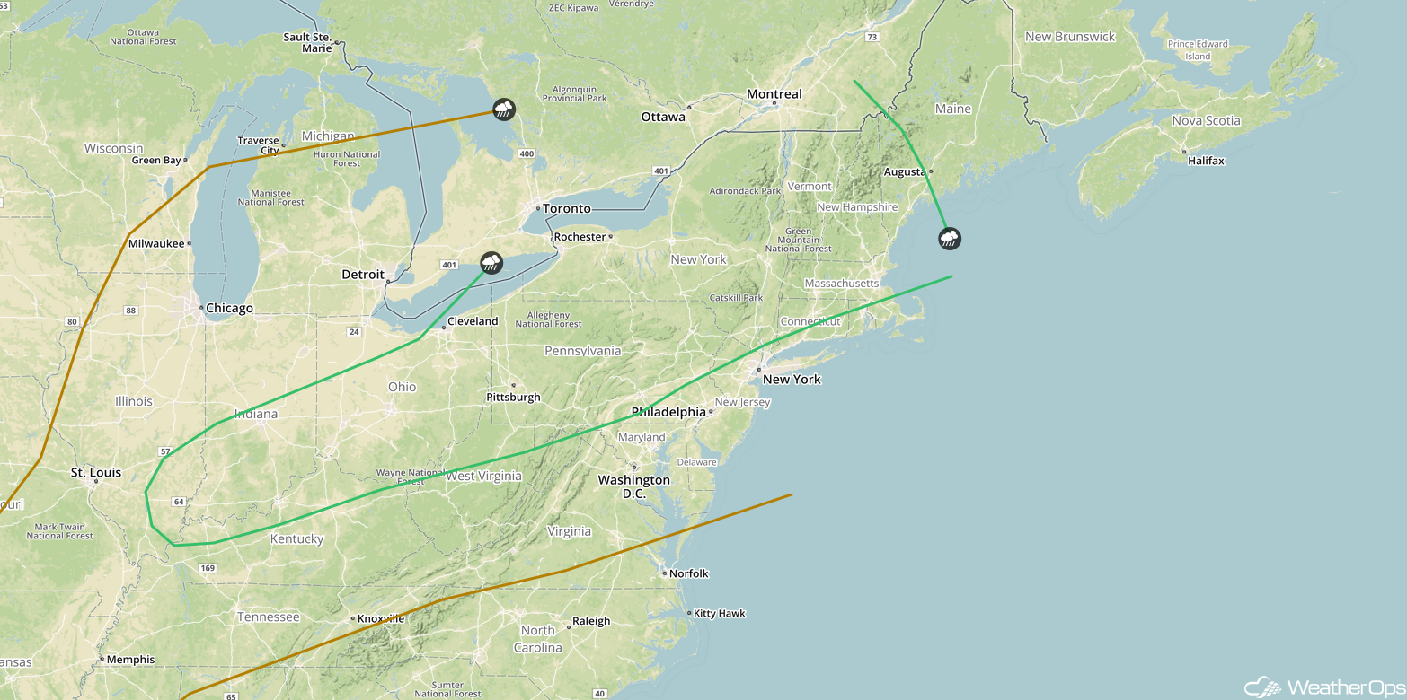 SPC Convective Outlook for Friday
Excessive Rainfall for South Texas Friday
A cold front will be slowly moving southward across Texas on Friday. At the same time, a trough will be moving across the region. This should provide enough lift for the development of showers and thunderstorms. Rainfall could be heavy with these storms with amounts ranging 1-2 inches and locally higher amounts in excess of 3 inches.
Major Cities in Region: Del Rio, TX, San Antonio, TX, Austin, TX, Waco, TX
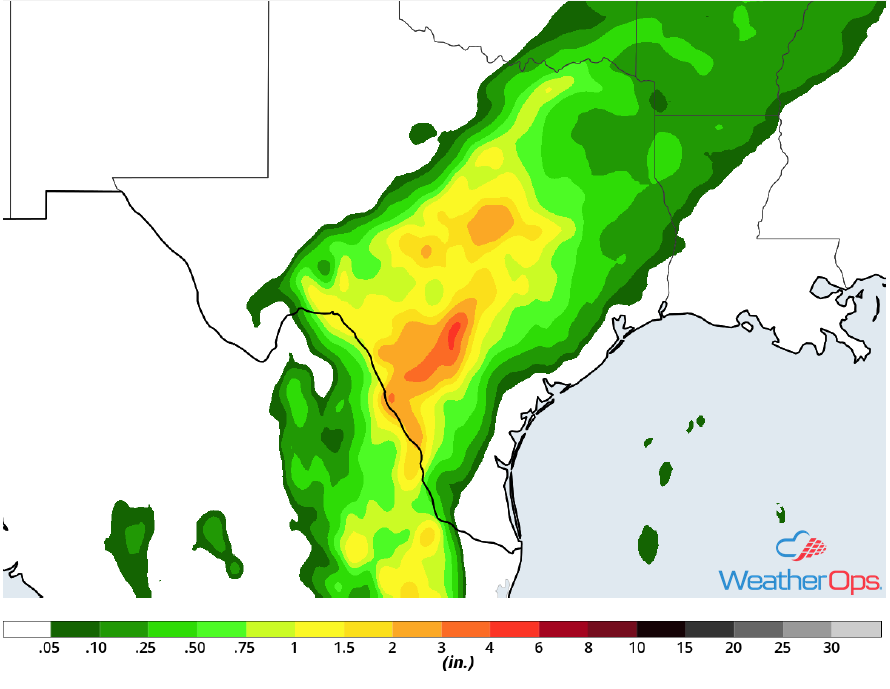 Rainfall Accumulation for Friday
A Look Ahead
Light rain will extend from the Mid Atlantic into the Lower Mississippi Valley ahead of a front on Saturday. Going into Sunday, a few showers may develop across the Great Lakes in association with a cold front. Light rain is forecast for portions of the Northern Rockies on Monday; this activity will move into the Northern Plains and Upper Midwest on Tuesday.
This is just a brief look at current weather hazards. We can provide you site-specific weather forecast information for the purpose of protecting your personnel and assets and to assess your weather risk. Try a 7-day demo right away and learn how timely precision weather information can enhance your bottom line.
