


by David Moran, on Jun 7, 2018 11:41:23 AM
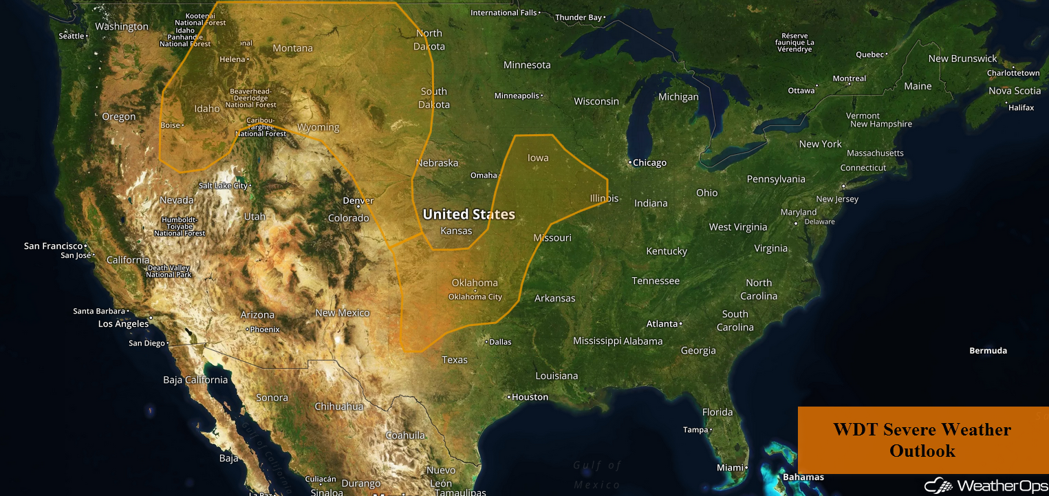
Thunderstorms are forecast to develop across portions of the Northern Rockies and Western High Plains on Thursday along a stalled front. Across the Upper Midwest into the Southern Plains, there will be a potential for thunderstorms through the day. As multiple rounds of thunderstorms move across portions of the Central Plains and Midwest, there will be a risk for flash flooding.
- Potential for Thunderstorms across the Northern Rockies and Western High Plains on Thursday
- Thunderstorms Thursday from the Upper Midwest into the Southern Plains
- Excessive Rainfall for the Central Plains and Upper Midwest Thursday Evening through Early Friday Morning
- Risk for Thunderstorms Friday from the Northern and Central Plains into the Midwest
- Potential for Excessive Rainfall across the Midwest Friday
- Thunderstorms Saturday from the Central Plains to the Mid Atlantic
- Thunderstorm Potential from the Northern Rockies into the Northern and Central Plains on Saturday
 US Hazards

Potential for Thunderstorms across the Northern Rockies and Western High Plains on Thursday
A weak area of low pressure is expected to be situated over eastern Montana along a stalled front. Strong wind shear will be in place to the east of the low and as a result, there will be a low risk for isolated tornadoes. More widespread thunderstorms capable of producing large hail and damaging winds are forecast during the afternoon. Storms will likely develop across west central Montana during the early to mid afternoon. By late afternoon, severe thunderstorms are likely to develop and expand into eastern Montana and the western High Plains through the evening.
Major Cities in Region: Helena, MT, Billings, MT, Rapid City, SD, Scottsbluff, NE
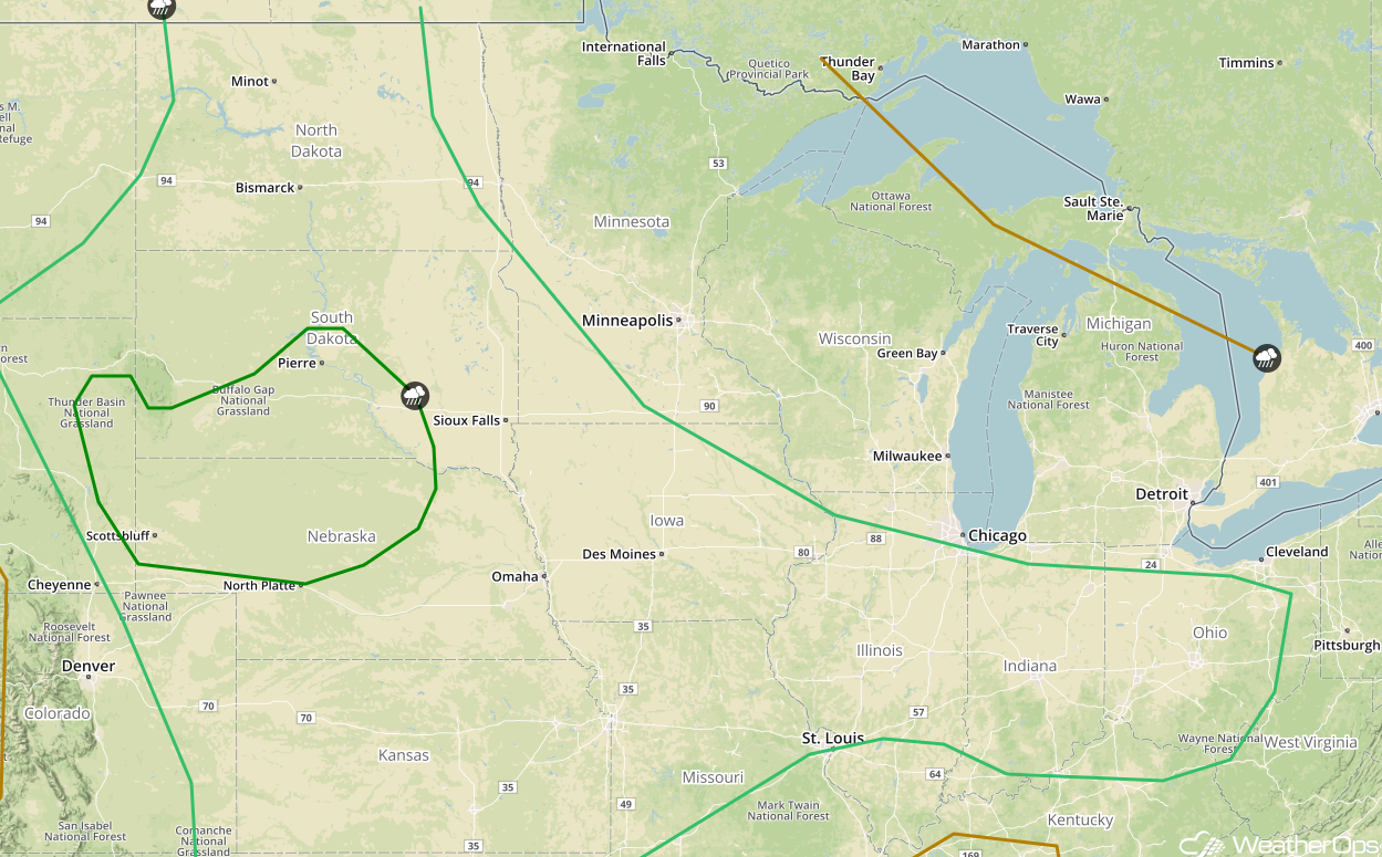
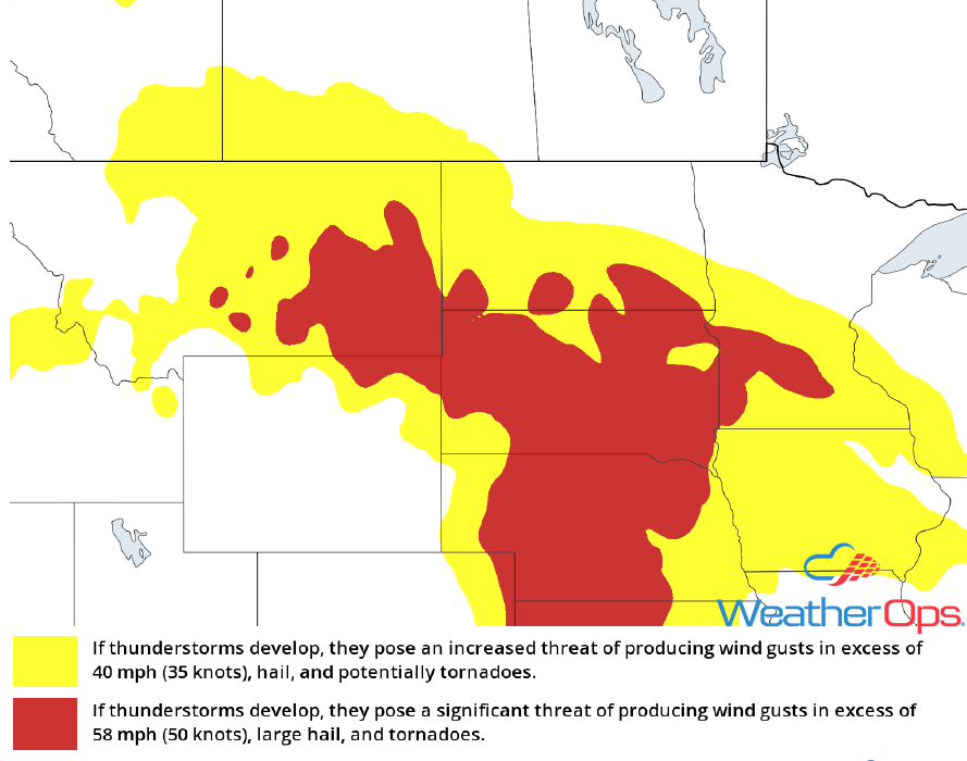 Thunderstorm Risk for Thursday
Thunderstorms Thursday from the Upper Midwest into the Southern Plains
Thunderstorms will continue for portions of the Southern Plains through the morning. While there is some uncertainty due to morning thunderstorm activity, another round of storms may develop this afternoon across Western Oklahoma. Large hail and damaging winds will be the primary hazards with these storms. Elsewhere, clusters of storms may redevelop across the Central Plains and Upper Midwest between late this afternoon and midnight.
Major Cities in Region: Goodland, KS, Dodge City, KS, Wichita, KS, Oklahoma City, OK, Omaha, NE, Des Moines, IA
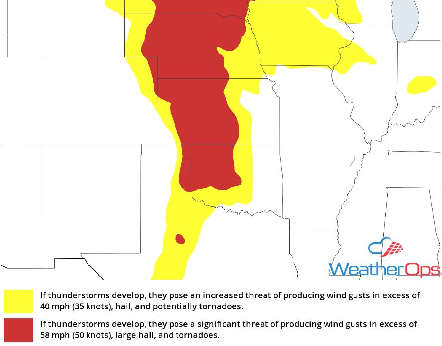 Thunderstorm Risk for Thursday
Excessive Rainfall for the Central Plains and Upper Midwest Thursday Evening through Early Friday Morning
Multiple rounds of heavy thunderstorms are expected to move across the region late this evening through early Friday morning. Rainfall accumulations of 1-2 inches are forecast, resulting in localized flash flooding.
Major Cities in Region: Bismarck, ND, Pierre, SD
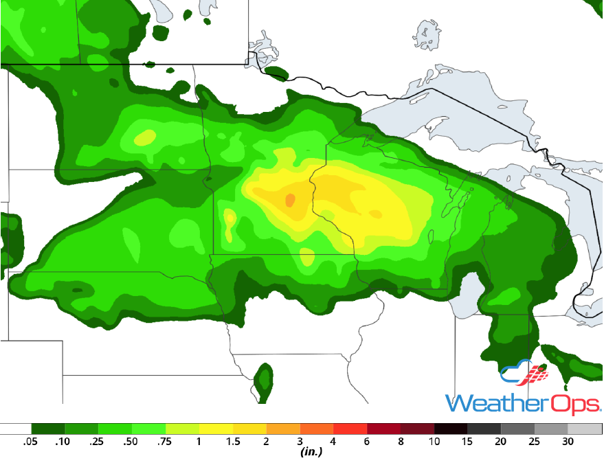
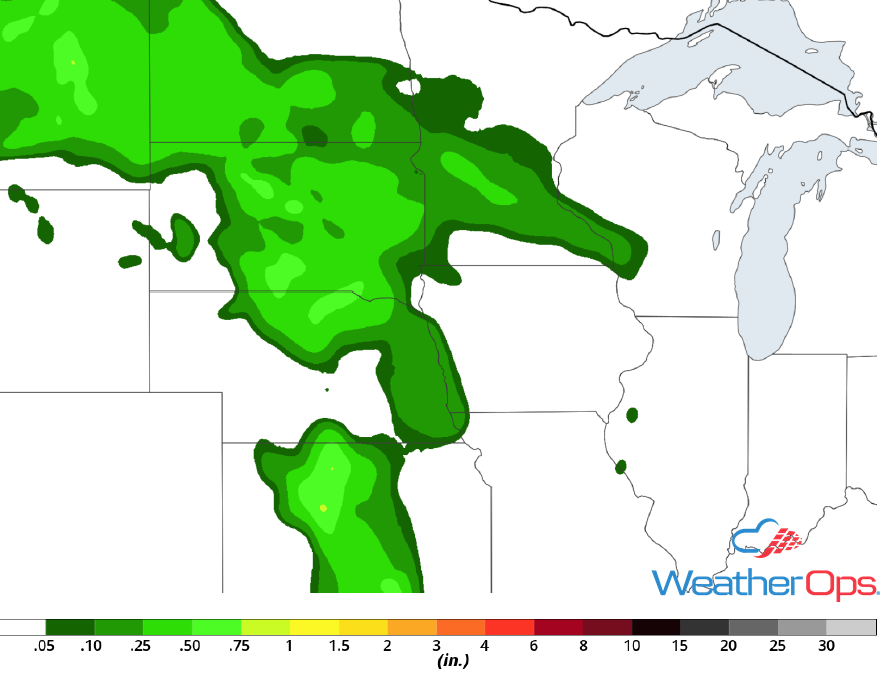 Rainfall Accumulation for Thursday
Risk for Thunderstorms Friday from the Northern and Central Plains into the Midwest
A front will remain stalled across the western High Plains into the Upper Midwest on Friday. Weak disturbances will promote the development of thunderstorm clusters along and near the front. Storms weakening over Minnesota and Iowa may reorganize as they move eastward. However, additional storms may develop late Friday afternoon and evening along the front. Storms will likely extend from South Dakota southward into northern Kansas. Large hail and damaging winds will be the primary hazards with these storms.
Major Cities in Region: Scottsbluff, NE, North Platte, NE, Minot, ND, Bismarck, ND, Pierre, SD, Omaha, NE, Des Moines, IA
 SPC Convective Outlook for Friday
Potential for Excessive Rainfall across the Midwest Friday
Multiple rounds of storms are expected across portions of the Midwest on Friday, bringing the potential for heavy to excessive rainfall. Thunderstorms are forecast across the region during the morning, with additional activity expected Friday evening and early Saturday morning. Rainfall totals of 1-2 inches are expected, leading to a risk for flash flooding.
Major Cities in Region: Minneapolis, MN, Wausau, WI
 Rainfall Accumulation for Friday
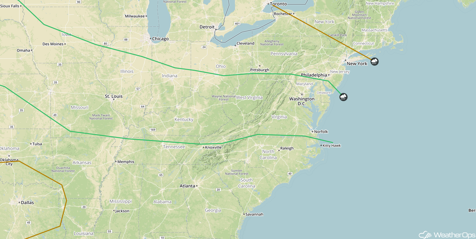
Thunderstorms Saturday from the Central Plains to the Mid Atlantic
Weakening showers and a few embedded thunderstorms will likely be ongoing early Saturday morning from Iowa and Missouri eastward into Indiana and Ohio. These storms will move eastward along a stalled front and will likely intensify later in the day. Damaging winds and large hail will be the primary hazards with these storms.
Major Cities in Region: Des Moines, IA, St. Louis, MO, Indianapolis, IN, Cincinnati, OH, Charleston, WV, Washington, DC
 SPC Convective Outlook for Saturday
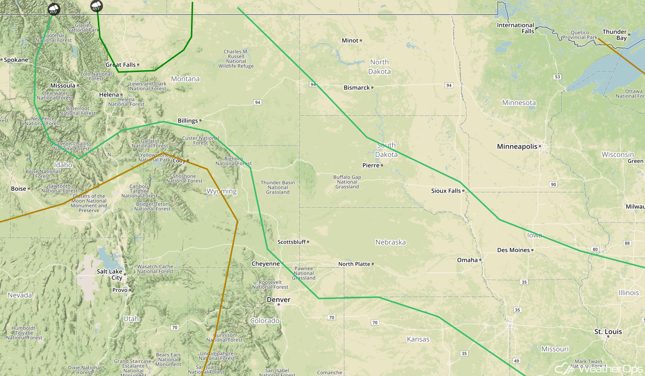
Thunderstorm Potential from the Northern Rockies into the Northern and Central Plains on Saturday
Thunderstorms from Friday night may continue into Saturday morning. However, as another cold front moves into the region, there will be a risk of thunderstorms from the Dakotas and Nebraska eastward during the afternoon and evening. Damaging winds and large hail will be the primary hazards, but an isolated tornado cannot be ruled out.
Major Cities in Region: Missoula, MT, Helena, MT, Great Falls, MT, Billings, MT, North Platte, NE Pierre, SD, Sioux Falls, SD, Omaha, NE
 SPC Convective Outlook for Saturday
A Look Ahead
Showers and thunderstorms will continue from the Mid Mississippi Valley eastward to the Mid Atlantic on Sunday as an area of low pressure and cold front continue to move eastward. On Monday, an area of low pressure will bring the potential for thunderstorms to portions of the Northern Plains and Upper Midwest. This activity will continue to move eastward into the Great Lakes and Ohio Valley on Tuesday. By Wednesday, showers and thunderstorms may develop across the Southeast.
This is just a brief look at current weather hazards. We can provide you site-specific weather forecast information for the purpose of protecting your personnel and assets and to assess your weather risk. Try a 7-day demo right away and learn how timely precision weather information can enhance your bottom line.
