


by David Moran, on Jun 28, 2018 11:32:18 AM
An area of low pressure will develop across the Northern High Plains on Thursday and aid in the development of severe thunderstorms across portions of the Northern Plains. These storms will have the potential to produce heavy rain. Thunderstorms may develop across portions of the Southeast as instability builds through the afternoon. An upper level low will provide the forcing for the development of thunderstorms across portions of the Northeast. Some of these storms will pose a risk for excessive rainfall.
- Thunderstorms for the Northern Plains on Thursday
- Excessive Rainfall Thursday for the Northern Plains
- Thunderstorm Potential for the Southeast on Thursday
- Risk for Thunderstorms Thursday across the Northeast
- Potential for Excessive Rainfall across the Northeast Thursday
- Thunderstorms Friday for the Northern Plains and Upper Mississippi Valley
- Risk for Thunderstorms across the Central High Plains Friday
- Thunderstorm Potential Friday for the Southeast on Friday
- Thunderstorms from the Northern Plains into the Western Great Lakes Saturday
- Excessive Rainfall Saturday for the Great Lakes and Central Plains
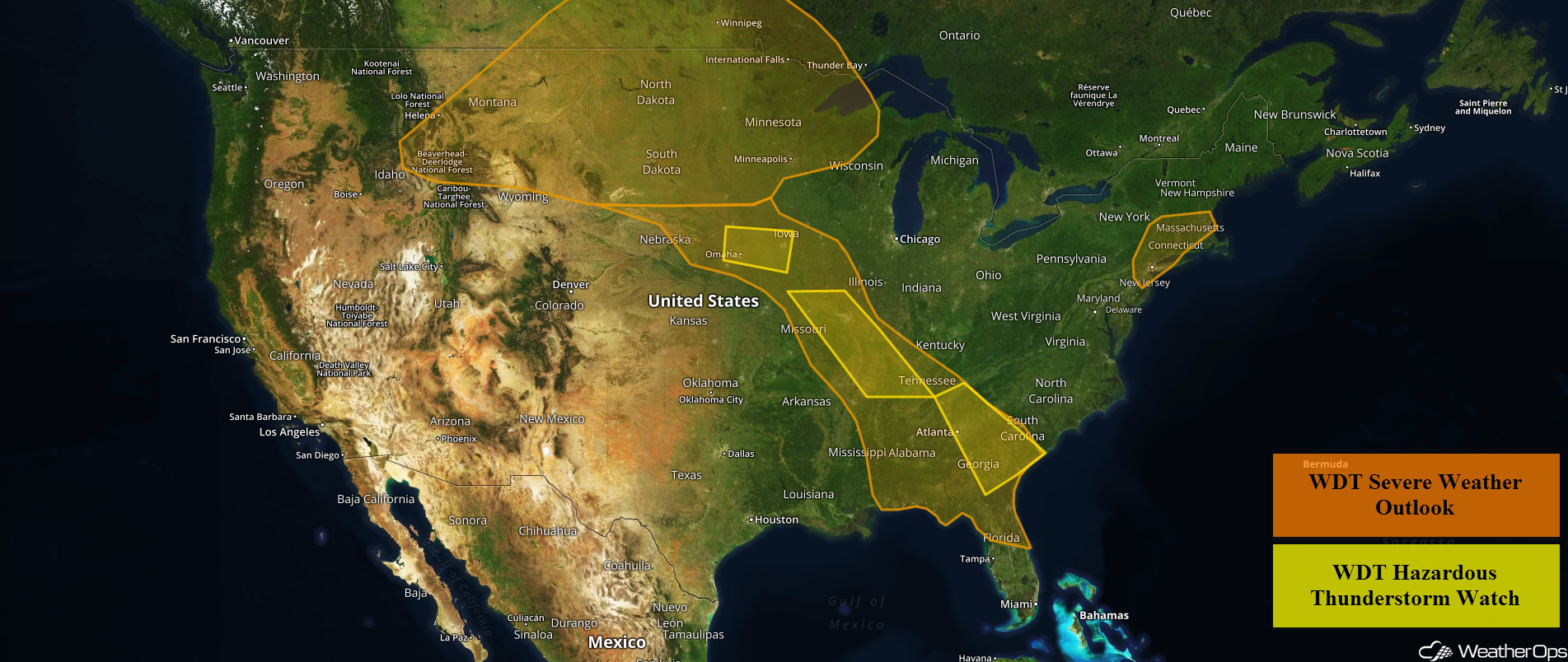 US Hazards

Thunderstorms for the Northern Plains on Thursday
As an upper level trough approaches the Northern Rockies, an area of low pressure is forecast to develop over Wyoming during the afternoon. Plentiful moisture will be in place ahead and to the north of the low. Instability will increase as daytime heating increases. As the trough approaches, strong to severe thunderstorms are expected across eastern Montana and into the Dakotas. When the low moves eastward, the risk for severe thunderstorms will also spread eastward. Storms may be supercells initially, capable of producing damaging winds and large hail. A few isolated tornadoes cannot be ruled out. Going into the overnight hours, storms may form clusters capable of producing damaging winds.
Major Cities in Region: Rapid City, SD, Minot, ND, Bismarck, ND, Pierre, SD
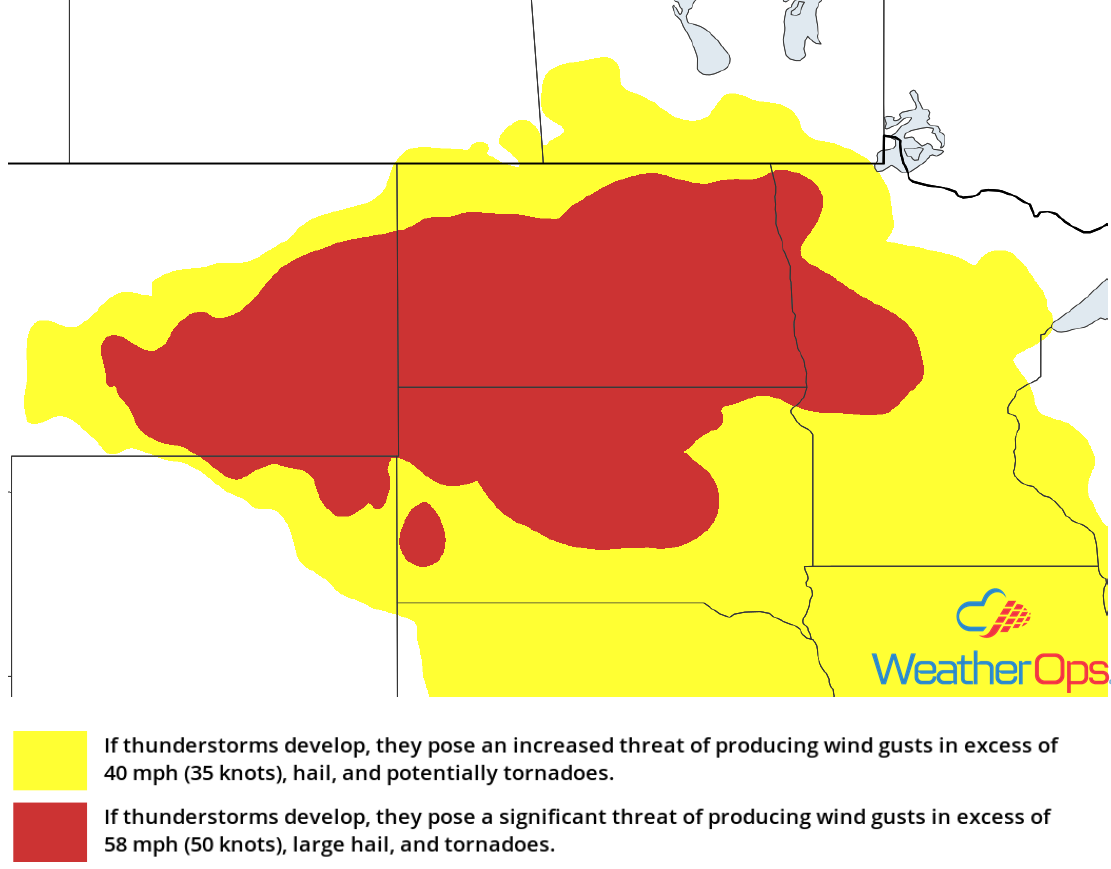 Thunderstorm Risk for Thursday
Excessive Rainfall Thursday for the Northern Plains
In addition to the severe weather threat, there will be a risk for excessive rainfall. Rainfall amounts of 2-3 inches with locally higher amounts in excess of 4 inches are expected.
Major Cities in Region: Dickinson, ND, Minot, ND, Bismarck, ND
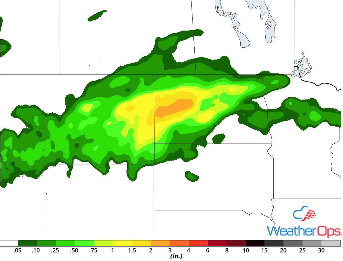 Rainfall Accumulation for Thursday
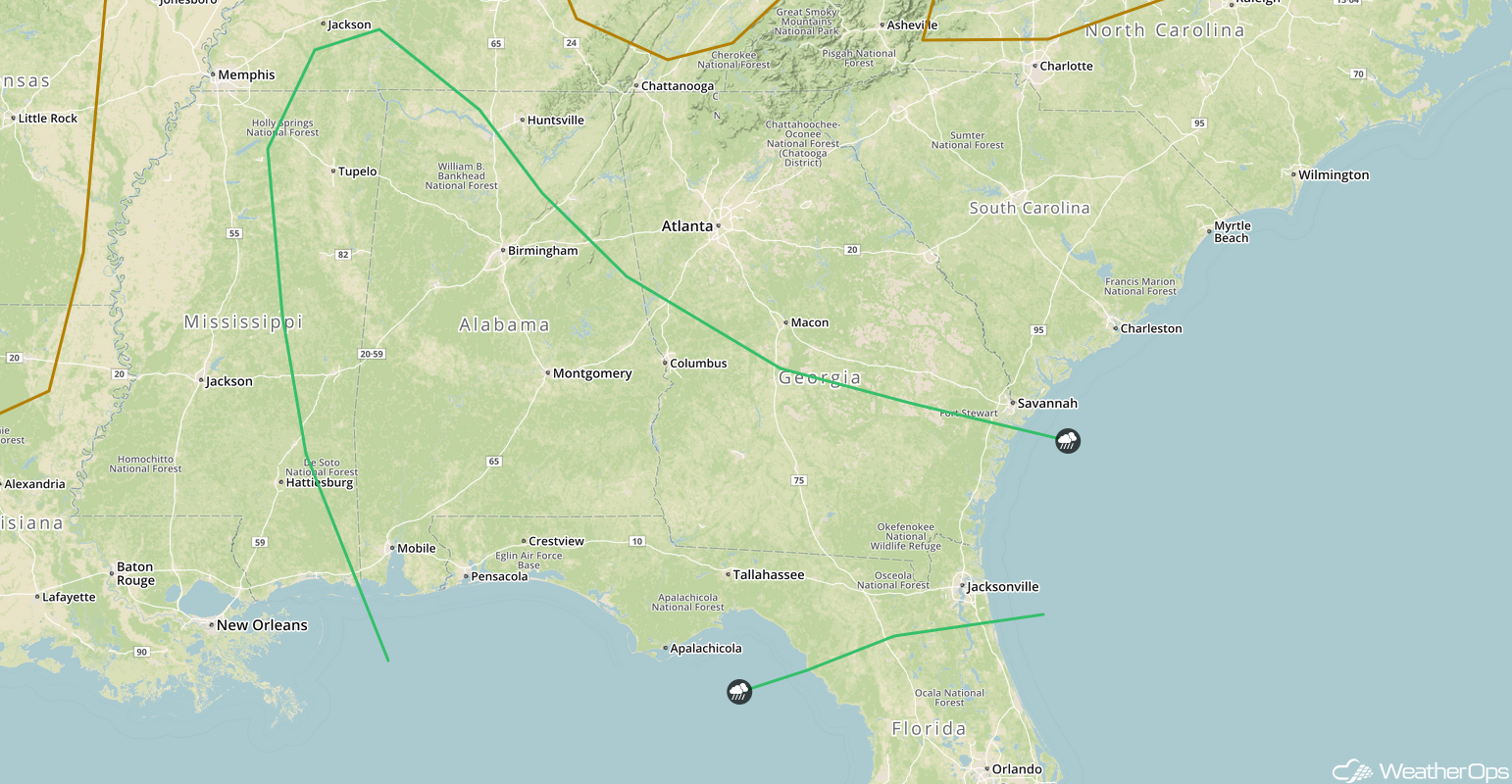
Thunderstorm Potential for the Southeast on Thursday
Warm, moist air in place over the southeastern US, along with cooling temperatures aloft, will result in strong instability across the region. Thunderstorm activity that is ongoing this morning will leave behind outflow boundaries which will be the focus for thunderstorm development during the afternoon. Damaging winds will be the primary hazard with these storms.
Major Cities in Region: Nashville, TN, Birmingham, AL, Atlanta, GA
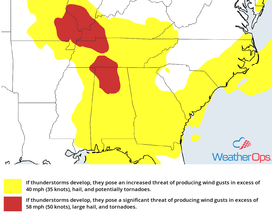 Thunderstorm Risk for Thursday
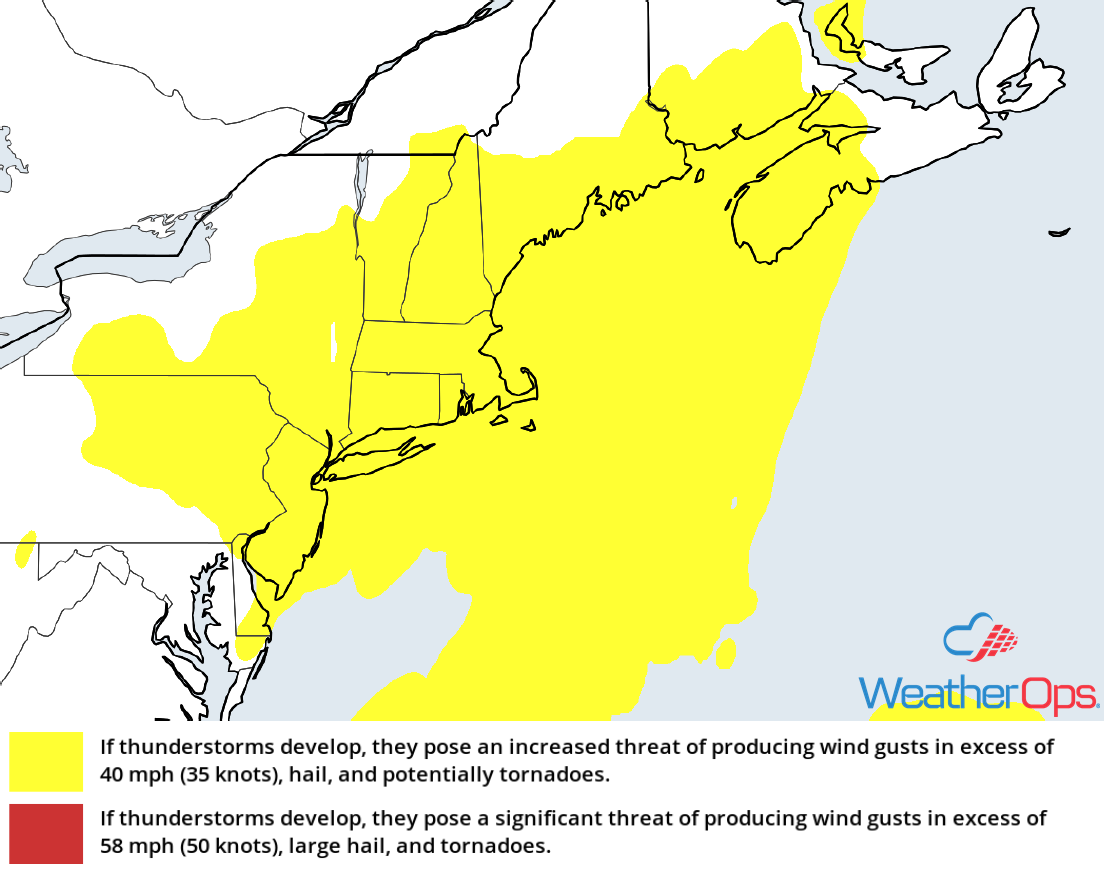
Risk for Thunderstorms Thursday across the Northeast
Showers and thunderstorms are ongoing over the Northeast this morning ahead of an upper level trough. Additional activity is expected this afternoon as the upper level low continues to move eastward and a weak cold front approaches from the west. Damaging winds will be the primary hazards with these storms.
Major Cities in Region: New York, NY, Hartford, CT, Providence, RI, Boston, MA
 Thunderstorm Risk for Thursday
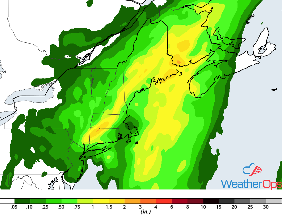
Potential for Excessive Rainfall across the Northeast Thursday
In addition to the thunderstorms, there will be the potential for excessive rainfall as the cold front described above continues to move eastward. Rainfall totals of 1-2 inches with locally higher amounts in excess of 3 inches are forecast.
Major Cities in Region: New York, NY, Bridgeport, CT, Portland, ME, Augusta, ME
 Rainfall Accumulation for Thursday
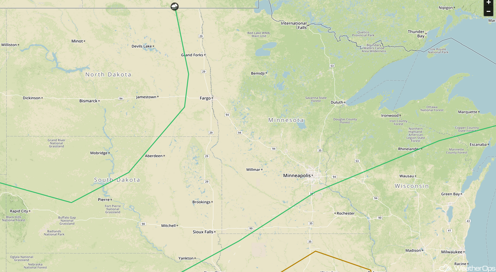
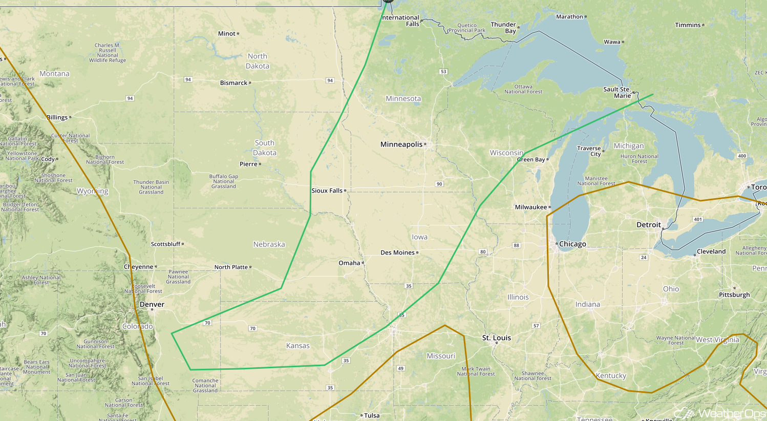
Thunderstorms Friday for the Northern Plains and Upper Mississippi Valley
The area of low pressure moving across the Plains today and tonight will move across the Upper Mississippi Valley on Friday. Strong to severe thunderstorms are expected to develop near the low and along its cold front, which is expected to extend southwestward. Storms will be ongoing during the morning but should re-intensify during the afternoon as daytime heating increases instability. Damaging winds and large hail will be the primary hazards with these storms.
Major Cities in Region: Rapid City, SD, Pierre, SD, Sioux Falls, SD, International Falls, MN, Minneapolis, MN, Duluth, MN
 SPC Convective Outlook for Friday
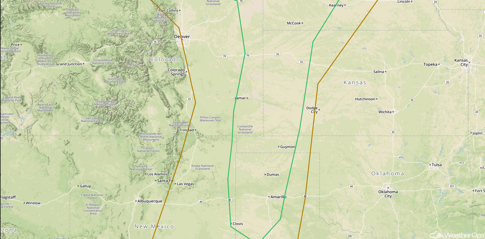
Risk for Thunderstorms across the Central High Plains Friday
An area of low pressure is forecast to develop in the lee of the Rockies on Friday. This should enhance southeasterly flow, allowing instability to build. As a result, isolated strong to severe thunderstorms are expected to develop. Damaging winds will be the primary hazard, but some storms may produce large hail.
Major Cities in Region: Lamar, CO, Clovis, NM, Goodland, KS, Amarillo, TX, Guymon, OK
 SPC Convective Outlook for Friday
Thunderstorm Potential Friday for the Southeast on Friday
Thunderstorms are forecast once again across the Southeast on Friday as warm, moist air remains in place over the region. A weak cold front and daytime heating will allow for the development of thunderstorms during the afternoon. Damaging winds and an isolated tornado or two will be the primary hazards with these storms. Activity may continue into the overnight hours.
Major Cities in Region: Mobile, AL, Birmingham, AL, Tallahassee, FL, Jacksonville, FL
 SPC Convective Outlook for Friday
Thunderstorms from the Northern Plains into the Western Great Lakes Saturday
A very warm and unstable air mass will be in place ahead of a cold front extending from Minnesota into Colorado. Additional lift will be provided by an upper level trough moving across the Northern Plains. As instability increases ahead of the front, thunderstorms will begin to develop during the afternoon. Large hail, damaging winds, and tornadoes will all be potential hazards with these storms. As storms begin to cluster in the evening, damaging winds will become the primary hazard.
Major Cities in Region: Sioux Falls, SD, Omaha, NE, Des Moines, IA, Minneapolis, MN, Wausau, WI
 SPC Convective Outlook for Saturday
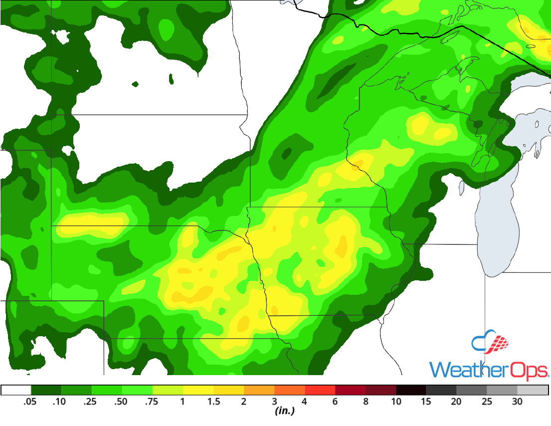
Excessive Rainfall Saturday for the Great Lakes and Central Plains
Thunderstorms developing across the Great Lakes and Plains will have the potential to produce heavy rainfall. Rainfall amounts of 1-2 inches with locally higher amounts in excess of 3 inches are forecast, especially with thunderstorms that form clusters.
Major Cities in Region: Omaha, NE, Des Moines, IA, Minneapolis, MN, Wausau, WI
 Rainfall Accumulation for Saturday
A Look Ahead
As the cold front moving across the Plains continues to move eastward on Sunday, thunderstorms may develop from the Great Lakes southwestward into the Plains. By Monday, showers will extend from the Great Lakes into the Southeast. An area of low pressure moving across the Plains will bring a potential for showers and thunderstorms to the Northern Plains and Upper Midwest on Tuesday. On Wednesday, showers and thunderstorms may extend from the Great Lakes into the Lower Mississippi Valley.
This is just a brief look at current weather hazards. We can provide you site-specific weather forecast information for the purpose of protecting your personnel and assets and to assess your weather risk. Try a 7-day demo right away and learn how timely precision weather information can enhance your bottom line.
