


by David Moran, on Jun 21, 2018 12:12:51 PM
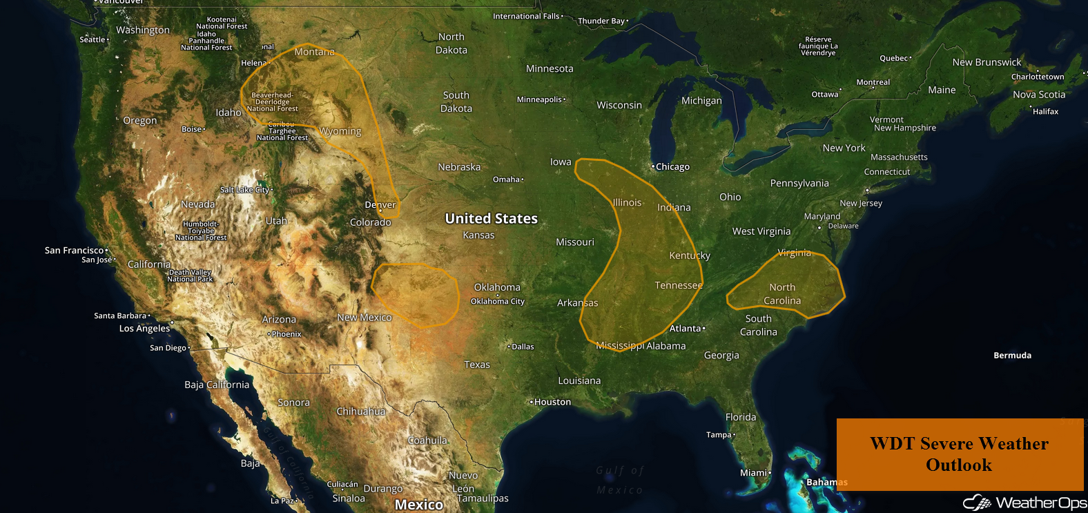
Thunderstorms are forecast to develop across North Carolina and Virginia on Thursday as instability increases across the region. A cold front will be the focus for the development of thunderstorms during the afternoon and evening across the Mid to Lower Mississippi Valley. Upslope flow and daytime heating will allow for the development of thunderstorms across the Southern High Plains. An upper level trough will track eastward across Montana and the Front Range, bringing a potential for thunderstorms. There is a risk for excessive rainfall from the Midwest into the Mid-Atlantic along a stalled front.
- Potential for Thunderstorms across North Carolina and Virginia on Thursday
- Risk for Thunderstorms Thursday for the Mid and Lower Mississippi Valley
- Thunderstorms for the Southern High Plains on Thursday
- Thunderstorm Potential Thursday across Montana and the Front Range
- Excessive Rainfall from the Midwest into the Mid Atlantic on Thursday
- Thunderstorms from the Front Range into the Southern Plains Friday
- Risk for Excessive Rainfall Friday and Saturday across the Southern Plains
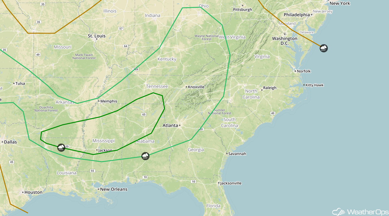
- Risk for Thunderstorms from the Lower Mississippi Valley into the Ohio Valley Friday
- Potential for Excessive Rainfall Friday for the Lower Mississippi River Valley
- Excessive Rainfall from Ohio to West Virginia Friday
- Thunderstorms Saturday for the Southern Plains
 US Hazards

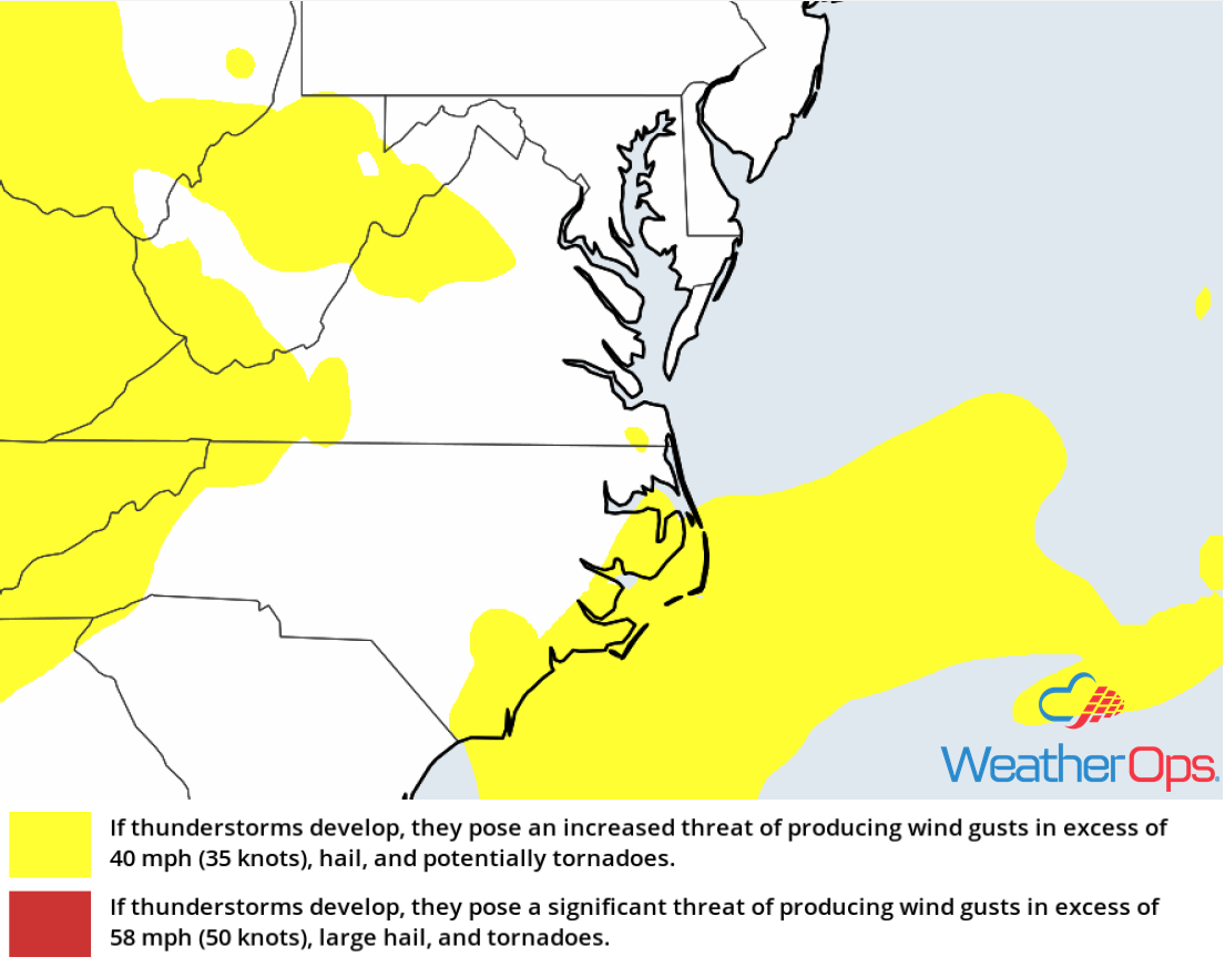
Potential for Thunderstorms across North Carolina and Virginia on Thursday
Strong daytime heating will lead to ample instability across portions of North Carolina and Virginia today. With plentiful moisture in place, scattered showers and thunderstorms are expected to develop near the Appalachians and track eastward. Some of these storms will be strong to severe with damaging winds being the primary hazard with the stronger storms. Activity should diminish as the sun sets and daytime heating is lost.
Major Cities in Region: Asheville, NC, Roanoke, VA, Charlottesville, VA
 Thunderstorm Risk for Thursday
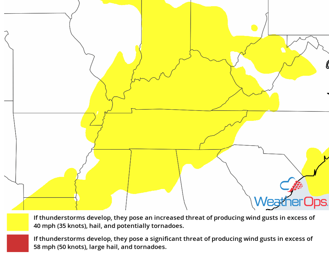
Risk for Thunderstorms Thursday for the Mid and Lower Mississippi Valley
An area of low pressure will move across the Missouri Valley with its associated cold front slowly moving eastward into the Mississippi River Valley this afternoon and evening. Ongoing rain and thunderstorm activity will quickly move out of the region this morning, allowing instability to build ahead of the front with daytime heating. With this instability, ample moisture, and lift provided by the cold front, scattered showers and thunderstorms are expected to develop along and ahead of the front. Some of these storms could become strong to severe with damaging winds and large hail the primary hazards.
Major Cities in Region: Memphis, TN, Jackson, MS
 Thunderstorm Risk for Thursday
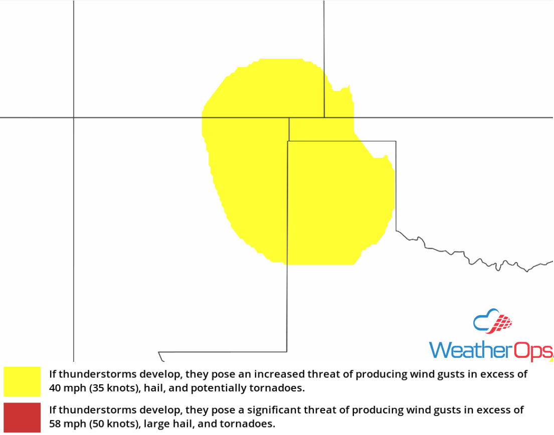
Thunderstorms for the Southern High Plains on Thursday
An upper level trough will be tracking along the northern periphery of an upper level ridge centered in the Desert Southwest. As this trough makes its way into the High Plains during the afternoon, daytime heating and upslope flow will create an environment favorable for the development of thunderstorms across the higher elevations. These thunderstorms are forecast to track eastward this afternoon and evening with some of these storms becoming strong to severe. Damaging winds and large hail will be the primary hazards with the stronger storms. Activity should diminish with the loss of daytime heating.
Major Cities in Region: Tucumcari, NM, Amarillo, TX, Guymon, OK
 Thunderstorm Risk for Thursday
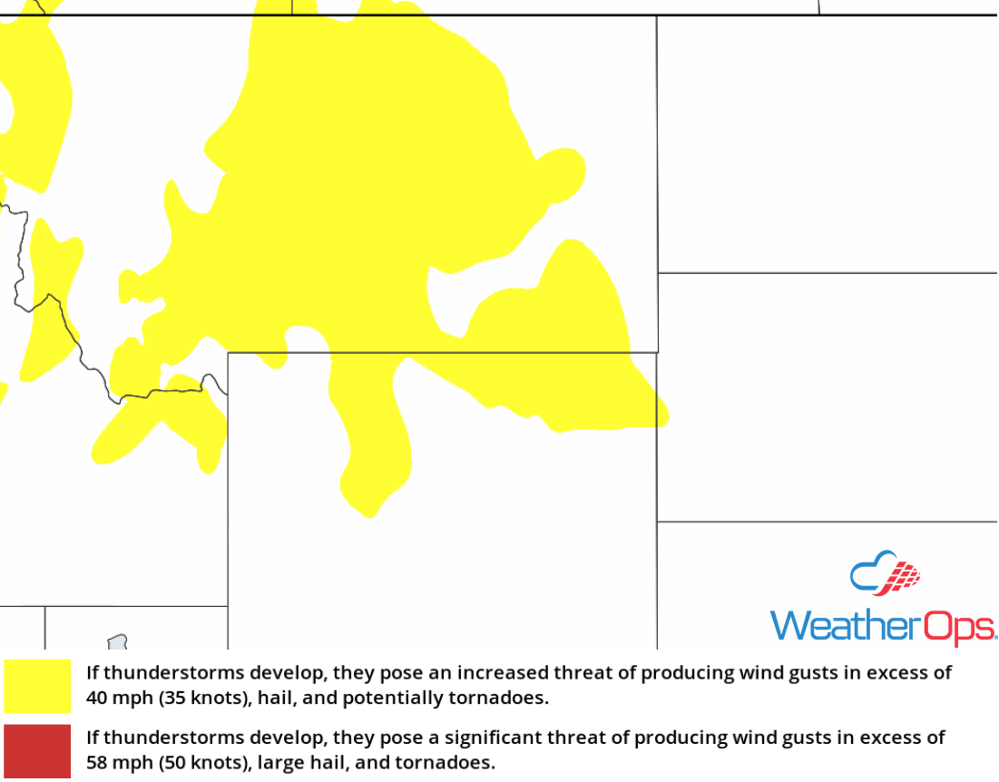
Thunderstorm Potential Thursday across Montana and the Front Range
An upper level trough currently in Oregon this morning will continue to track eastward throughout the day and be the focal point for showers and thunderstorms this afternoon. Daytime heating, upslope flow, and the trough will act to increase thunderstorm coverage across the region during the afternoon and evening. Some of these storms could become strong to severe with damaging winds and large hail being the primary hazards with the stronger storms.
Major Cities in Region: Great Falls, MT, Billings, MT, Glasgow, MT
 Thunderstorm Risk for Thursday
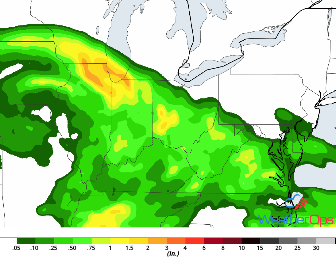
Excessive Rainfall from the Midwest into the Mid Atlantic on Thursday
A strong cut off low will be slowly moving eastward across the Missouri Valley into the Ohio River Valley and the Mid Atlantic. With ample moisture in place, as well as lift provided by the low and a stalled front, widespread moderate to heavy rainfall is forecast to the northeast of this low and along the stalled front. Rainfall amounts of 1-2 inches with locally higher amounts in excess of 3 inches are expected. This will bring the potential for flash flooding and excessive runoff across much of the region during the late morning and into the evening.
Major Cities in Region: Madison, WI, Milwaukee, WI, Chicago, IL, South Bend, IN, Columbus, OH, Charleston, WV, Charlottesville, VA
 Rainfall Accumulation for Thursday
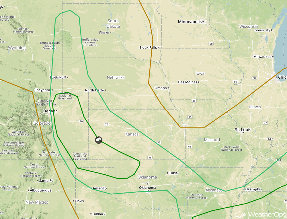
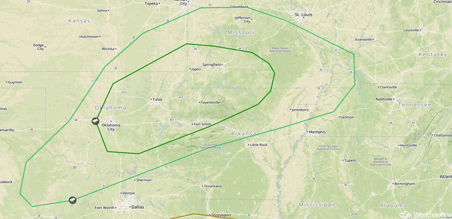
Thunderstorms from the Front Range into the Southern Plains Friday
An upper level low will track across the Rockies and into the Plains on Friday, with a surface low forecast to develop across the Texas Panhandle by Friday evening. With daytime heating and low level moisture creating ample instability, as well as upslope flow, conditions will be favorable for the development of isolated to scattered showers and thunderstorms. These storms will track eastward overnight with a few storms becoming strong to severe. Damaging winds, large hail, and tornadoes will be potential hazards with these storms.
Major Cities in Region: Denver, CO, Goodland, KS, Amarillo, TX, Dodge City, KS
 SPC Convective Outlook for Friday
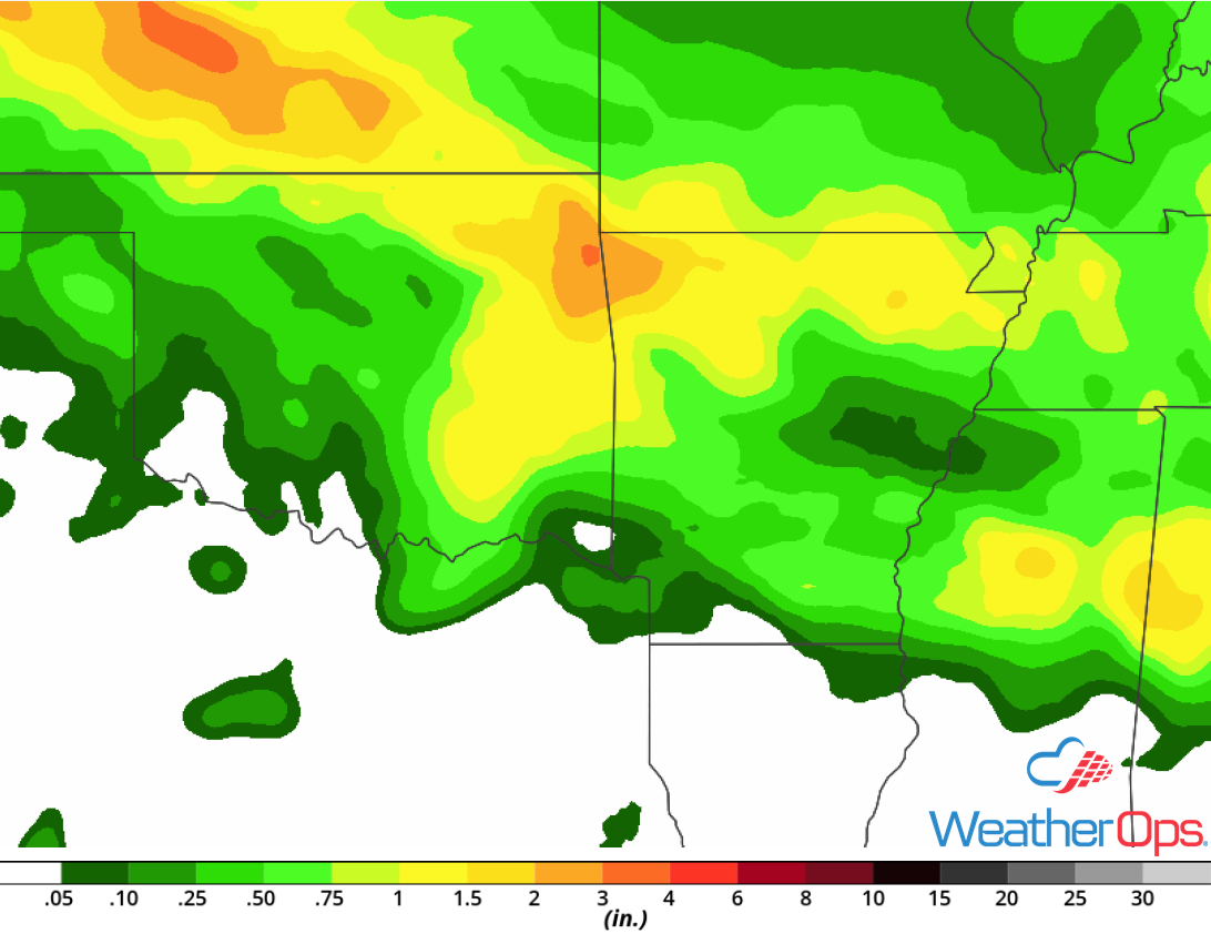
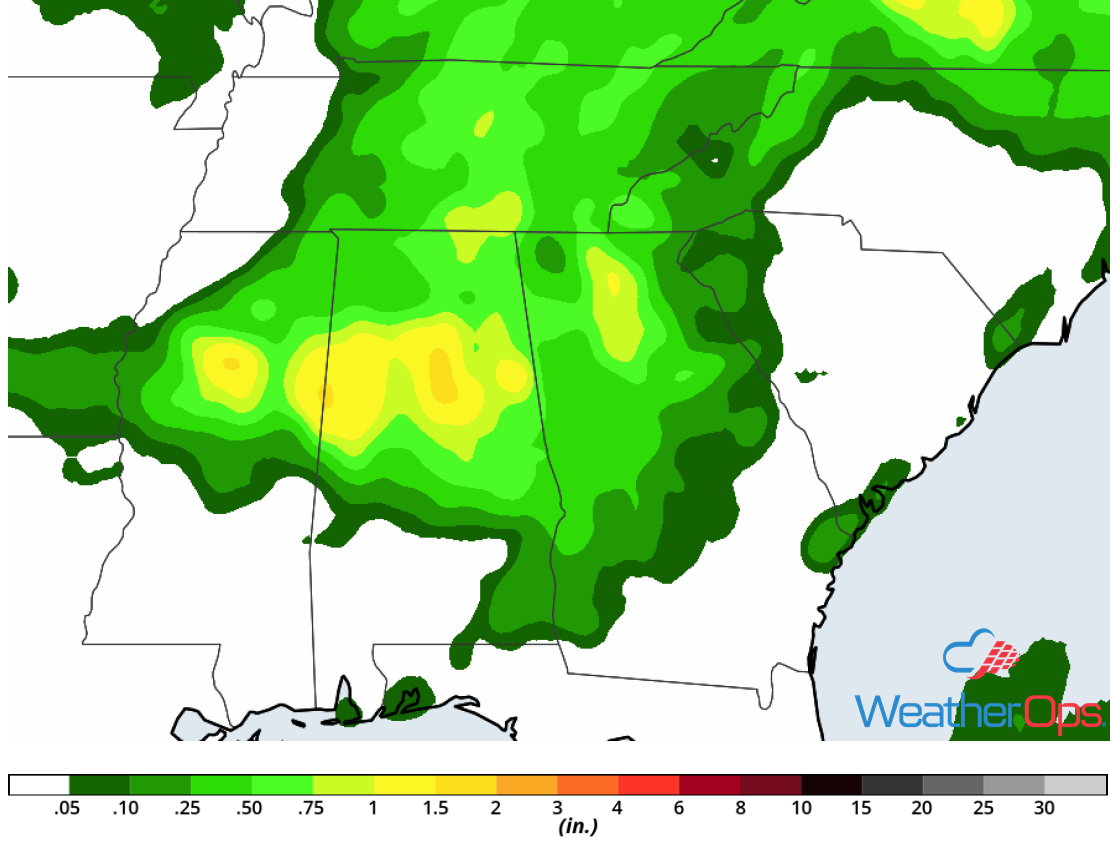
Risk for Excessive Rainfall Friday and Saturday across the Southern Plains
A frontal boundary is forecast to stall across the Southern Plains on Friday and move little on Saturday. During the afternoon and evening hours on Friday, scattered showers and thunderstorms are forecast to increase in coverage and intensity along this frontal boundary Friday evening. By Saturday morning, ongoing heavy rain and thunderstorms will be tracking eastward along this front. Given the ample moisture across the region and the continued heavy rainfall, the threat for excessive rainfall is becoming more likely across the region for Friday and Saturday. Rainfall accumulation of 2-4 inches with locally heavier amounts in excess of 6 inches are expected, leading to an enhanced threat of widespread flash flooding and excessive runoff.
Major Cities in Region: Wichita, KS, Tulsa, OK, Fayetteville, AR
 Rainfall Accumulation for Friday and Saturday
Risk for Thunderstorms from the Lower Mississippi Valley into the Ohio Valley Friday
An area of low pressure will track eastward across the Ohio River Valley on Friday. To the south of this low, ample moisture will spread northward from the Gulf Coast to the Ohio River Valley. With daytime heating creating ample instability, scattered thunderstorms are forecast to develop during the afternoon and evening. Some of these storms could be strong to severe with damaging winds and hail the primary hazards with the stronger storms.
Major Cities in Region: Memphis, TN, Jackson, MS, Birmingham, AL, Nashville, TN, Louisville, KY, Cincinnati, OH
 SPC Convective Outlook for Friday
Potential for Excessive Rainfall Friday for the Lower Mississippi River Valley
A frontal boundary is forecast to stall across the Lower Mississippi Valley Friday afternoon and evening. Daytime heating will create ample instability; with southerly flow bringing ample moisture northward, scattered showers and thunderstorms are expected across the region Friday afternoon and evening along this front. Multiple rounds of precipitation are forecast to move across the region during the overnight hours and increase in intensity. Rainfall accumulations of 1-2 inches with locally higher amounts in excess of 3 inches are expected. This will lead to a risk for flash flooding across portions of the Lower Mississippi Valley.
Major Cities in Region: Greenville, MS, Tupelo, MS
 Rainfall Accumulation for Friday
Excessive Rainfall from Ohio to West Virginia Friday
An area of low pressure will continue to track eastward along a stalled front across the Ohio River Valley. This will once again be the focal point for heavy to excessive rainfall on Friday across the region. With ample moisture in place, widespread showers and thunderstorms are forecast throughout the day. Rainfall totals of 0.50-1.00 inch with locally higher amounts in excess of 1.50 inches are expected across Ohio into West Virginia and Virginia. This will result in an increased risk for flash flooding and excessive runoff.
Major Cities in Region: Columbus, OH, Clarksburg, WV
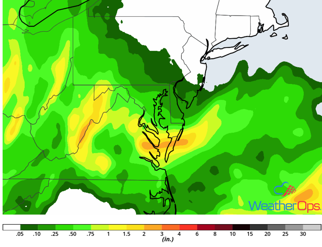
Rainfall Accumulation for Friday
Thunderstorms Saturday for the Southern Plains
Ongoing showers and thunderstorms are expected to track eastward across portions of the Southern Plains during the morning hours on Saturday. These thunderstorms will have the potential to produce damaging winds. Later in the morning, this activity is expected to weaken, but they will leave behind several outflow boundaries. Instability will build across much of the region and these outflow boundaries will be the focus for additional thunderstorm development during the afternoon and evening, Damaging winds, large hail, and a few tornadoes will be potential hazards with these storms.
Major Cities in Region: Lawton, OK, Oklahoma City, OK, Tulsa, OK, Fort Smith, AR, Springfield, MO
 SPC Convective Outlook for Saturday
A Look Ahead
Showers and thunderstorms from Saturday will move eastward into the Mid Mississippi and Ohio River Valleys on Sunday. On Monday, thunderstorms may develop across portions of the Central and Southern Plains as an area of low pressure develops. As this area of low pressure moves northeastward on Tuesday, thunderstorms will likely develop from the Great Lakes southwestward into the Plains. By Wednesday, showers and thunderstorms may develop across the Great Lakes southward into the Ohio Valley.
This is just a brief look at current weather hazards. We can provide you site-specific weather forecast information for the purpose of protecting your personnel and assets and to assess your weather risk. Try a 7-day demo right away and learn how timely precision weather information can enhance your bottom line.
