


by David Moran, on Jun 14, 2018 11:06:03 AM
Thunderstorms are forecast to develop across the Northern Plains on Thursday ahead of a cold front. Several rounds of thunderstorms across the Northern Plains and Upper Midwest will pose a risk for excessive rainfall through Saturday.
- Thunderstorms for the Northern Plains on Thursday
- Risk for Excessive Rainfall through Saturday for the Northern Plains and Upper Midwest
- Thunderstorm Potential for the Upper Midwest and Central Plains Friday
- Excessive Rainfall Friday into Saturday for the Southwest
- Risk for Thunderstorms for the Central Plains and Upper Midwest on Saturday
- Potential for Excessive Rainfall Saturday across the Northern Rockies
- Tropical Update
 US Hazards

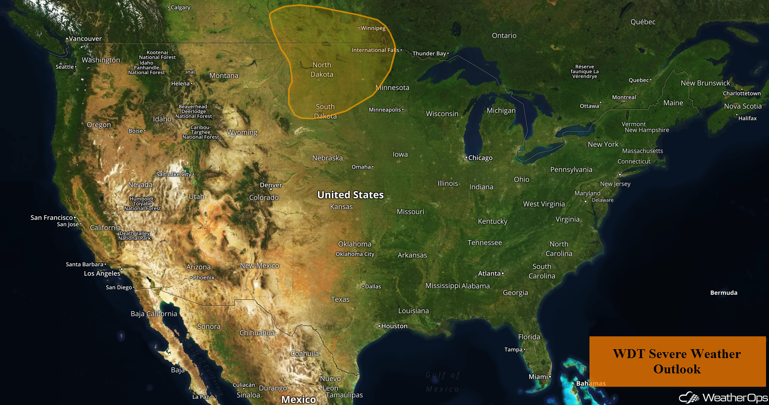
Thunderstorms for the Northern Plains on Thursday
Strong surface heating and plentiful moisture will create enough instability for the development of isolated thunderstorms across the Northern Plains on Thursday, some of which could be supercells. This activity is forecast to move eastward into the evening hours before evolving into one or two complexes. Large hail, damaging winds, and tornadoes will all be potential hazards. Storms will continue to move eastward through the overnight hours.
Major Cities in Region: Minot, ND, Bismarck, ND, Pierre, SD, Aberdeen, SD, Sioux Falls, SD, Grand Forks, ND, Fargo, ND
 Thunderstorm Risk for Thursday
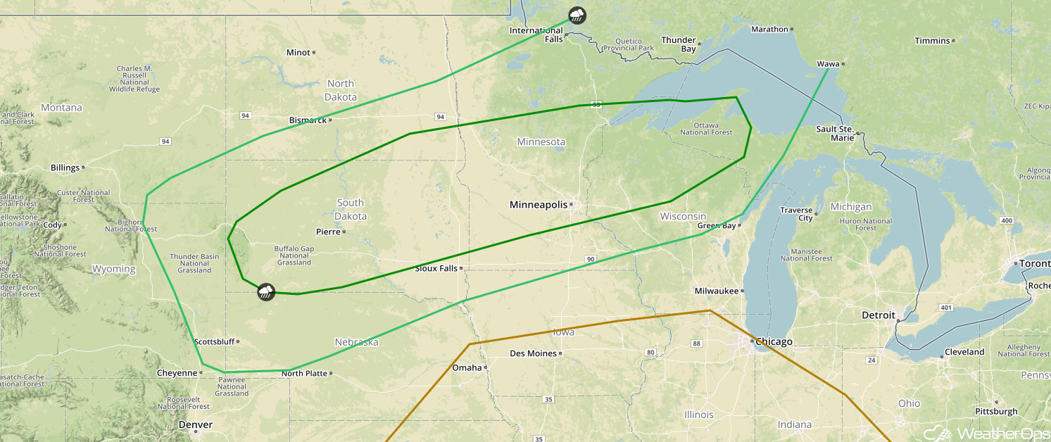
Risk for Excessive Rainfall through Saturday for the Northern Plains and Upper Midwest
Multiple rounds of showers and thunderstorms moving across the Northern Plains and Upper Midwest over the next three days will bring the potential for heavy to excessive rainfall. Each day, rainfall amounts will range 0.50-1.50 inch with locally higher amounts. Three day rainfall totals will range 1.50-4.50 inches with locally higher amounts. This will result in the potential for flooding and flash flooding across the area.
Major Cities in Region: Minot, ND, Bismarck, ND, Grand Forks, ND, Fargo, ND, Minneapolis, MN, Duluth, MN, Wausau. WI
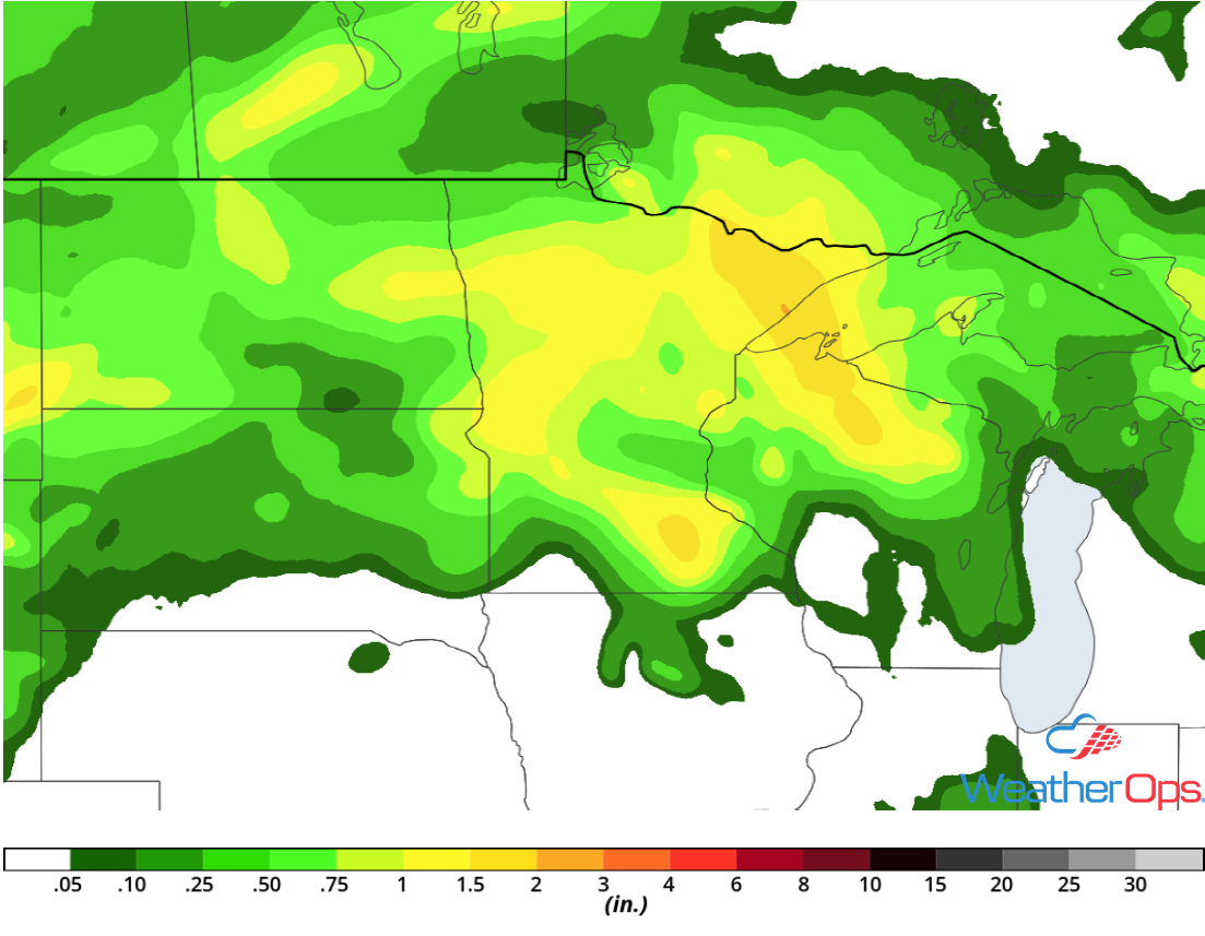 Rainfall Accumulation through Saturday
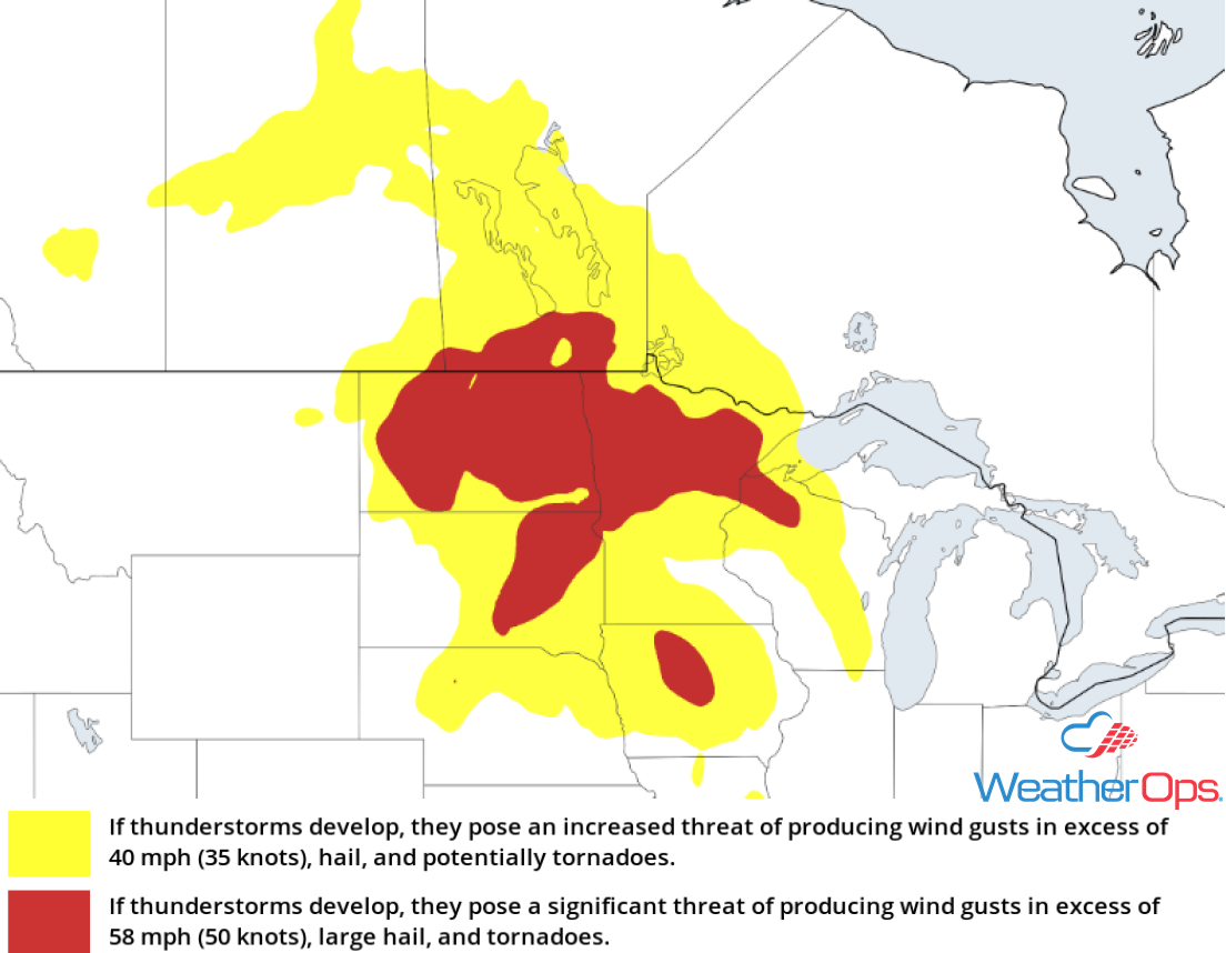
Thunderstorm Potential for the Upper Midwest and Central Plains Friday
Remnant clusters of thunderstorms will likely be ongoing across portions of the Upper Midwest Friday morning. Warm air moving northward may aid in additional thunderstorm development during the late morning, with damaging winds and hail the primary impacts. Outflow boundaries from the morning storms may allow for another round of storms during the evening with the main hazards being large hail and damaging winds. Further west across the Central Plains, a few supercells may develop along a stalled front by Friday afternoon. Damaging winds and large hail will be the primary hazards with these storms.
Major Cities in Region: Scottsbluff, NE, North Platte, NE, Pierre, SD, Sioux Falls, SD, Minneapolis, MN, Green Bay, WI, Milwaukee, WI
 SPC Convective Outlook for Friday
Excessive Rainfall Friday into Saturday for the Southwest
As the remnants from East Pacific Tropical Storm Bud move northward, heavy to excessive rainfall is forecast across the Southwestern US Friday into Saturday. On Friday, rainfall amounts will range 0.25-0.50 inch with locally higher amounts. Into Saturday, rainfall amounts of 0.50-1.50 inch are forecast. Two day rainfall totals near 2 inches with locally higher amounts are expected.
Major Cities in Region: Phoenix, AZ, Tucson, AZ
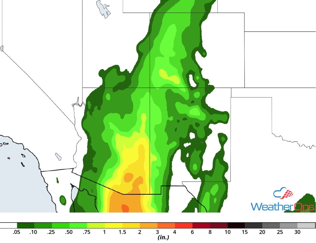 Rainfall Accumulation for Friday and Saturday
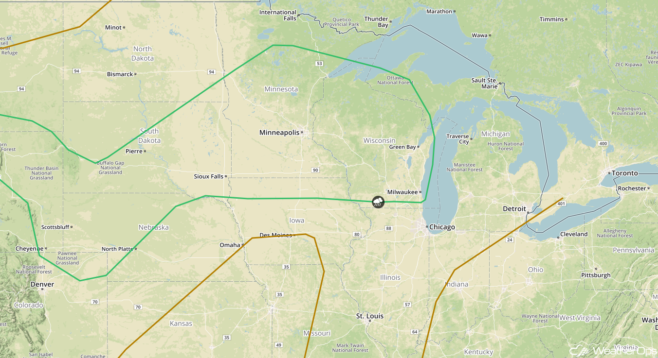
Risk for Thunderstorms for the Central Plains and Upper Midwest on Saturday
Strong daytime heating and plentiful moisture will allow for the development of thunderstorms ahead of a cold front on Saturday. Clusters of thunderstorms are expected to develop and move northeastward along the front. Damaging winds, large hail, and tornadoes will all be potential hazards with these storms.
Major Cities in Region: Scottsbluff, NE, Bismarck, ND, Pierre, SD, Sioux Falls, SD, Minneapolis, MN, Wausau, WI
 SPC Convective Outlook for Saturday
Potential for Excessive Rainfall Saturday across the Northern Rockies
Moisture moving in from the Northern Plains combined with the remnants of Tropical Storm Bud will bring the threat of heavy to excessive rainfall to the area on Saturday. Because this region has relatively wet soils from previous rainfall, flooding and flash flooding will be a concern. Rainfall totals will range 1-2 inches with locally higher amounts.
Major Cities in Region: Missoula, MT, Helena, MT, Great Falls, MT, Billings, MT
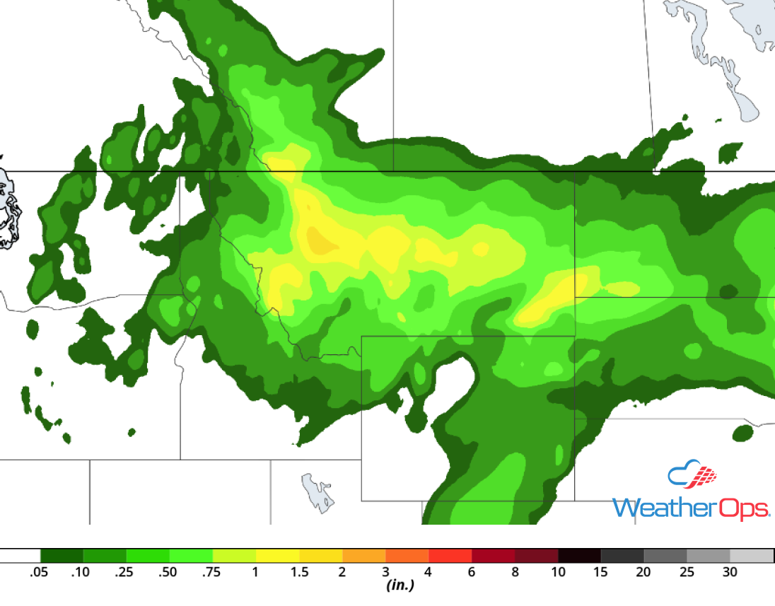 Rainfall Accumulation for Saturday
Tropical Update
An area of low pressure located over the Yucatan Peninsula is producing disorganized showers and thunderstorms. This activity is expected to move west-northwestward across the Yucatan Peninsula and over the southwestern Gulf of Mexico through Saturday. Development, if any, should be slow to occur due to strong upper level winds.
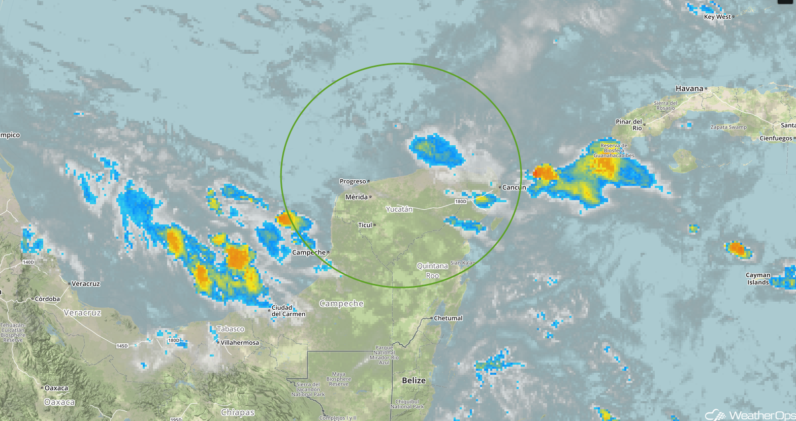 Enhanced Infrared Satellite
A Look Ahead
Showers and thunderstorms will continue across the Northern Plains and Upper Midwest Sunday into Monday along and ahead of a cold front. Across portions of Texas and Louisiana, heavy to excessive rainfall is forecast beginning Monday and continuing into Tuesday. Two day rainfall amounts of 3-6 inches with locally higher amounts in excess of 7 inches are currently forecast. By Monday afternoon and evening, showers and thunderstorms will extend from the Great Lakes into the Southern Plains. On Tuesday, showers and thunderstorms are forecast from the Ohio Valley into the Southern Plains. An area of low pressure may develop across the Southern High Plains on Wednesday, bringing a potential for showers and thunderstorms.
This is just a brief look at current weather hazards. We can provide you site-specific weather forecast information for the purpose of protecting your personnel and assets and to assess your weather risk. Try a 7-day demo right away and learn how timely precision weather information can enhance your bottom line.
