


by David Moran, on Jan 3, 2019 10:30:12 AM
Freezing rain and snow will continue across the Southern Plains through Friday as an area of low pressure moves northeastward. This same system will allow for the potential for excessive rainfall from the Lower Mississippi Valley into the Lower Tennessee Valley through Friday. Elevated winds and seas are expected across the northwestern Gulf of Mexico through Friday evening.
- Freezing Rain and Snow for the Southern Plains through Friday
- Excessive Rainfall through Friday from the Lower Mississippi Valley into the Lower Tennessee Valley
- Elevated Winds and Seas for the Northwestern Gulf of Mexico through Friday Evening
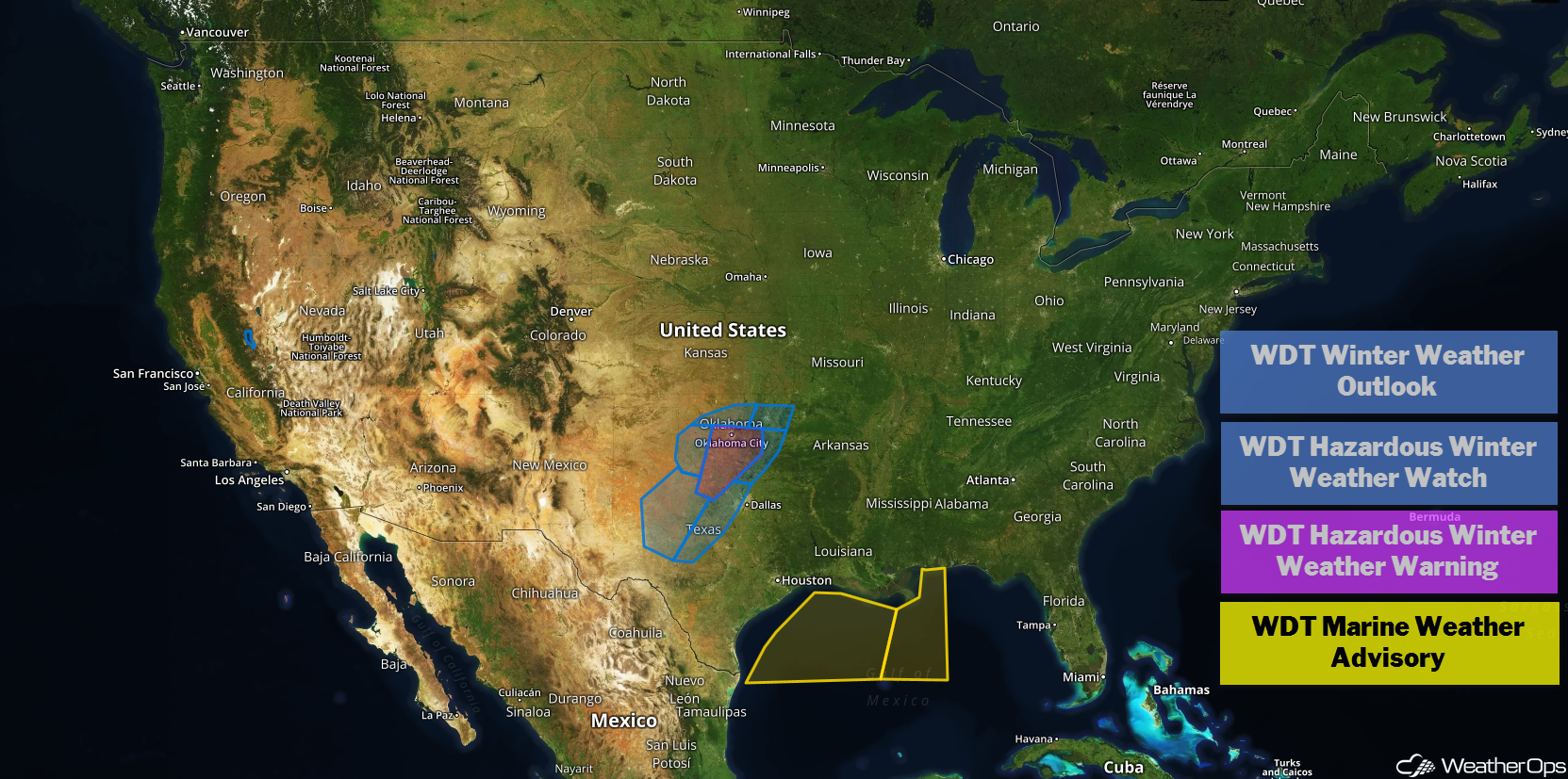
US Hazards
Freezing Rain and Snow for the Southern Plains through Friday
A winter storm will continue to impact the region as an area of low pressure moves off to the east-northeast. Freezing rain is beginning to change to snow across southwest Oklahoma and will spread east-northeastward through the morning. Some sleet may mix in during the afternoon. Snow accumulations in excess of 4 inches of snow, in addition to ice accumulations up to 0.10 inch, are expected.
Major Cities in Region: Abilene, TX, Wichita Falls, TX, Lawton, OK, Oklahoma City, OK, Tulsa, OK
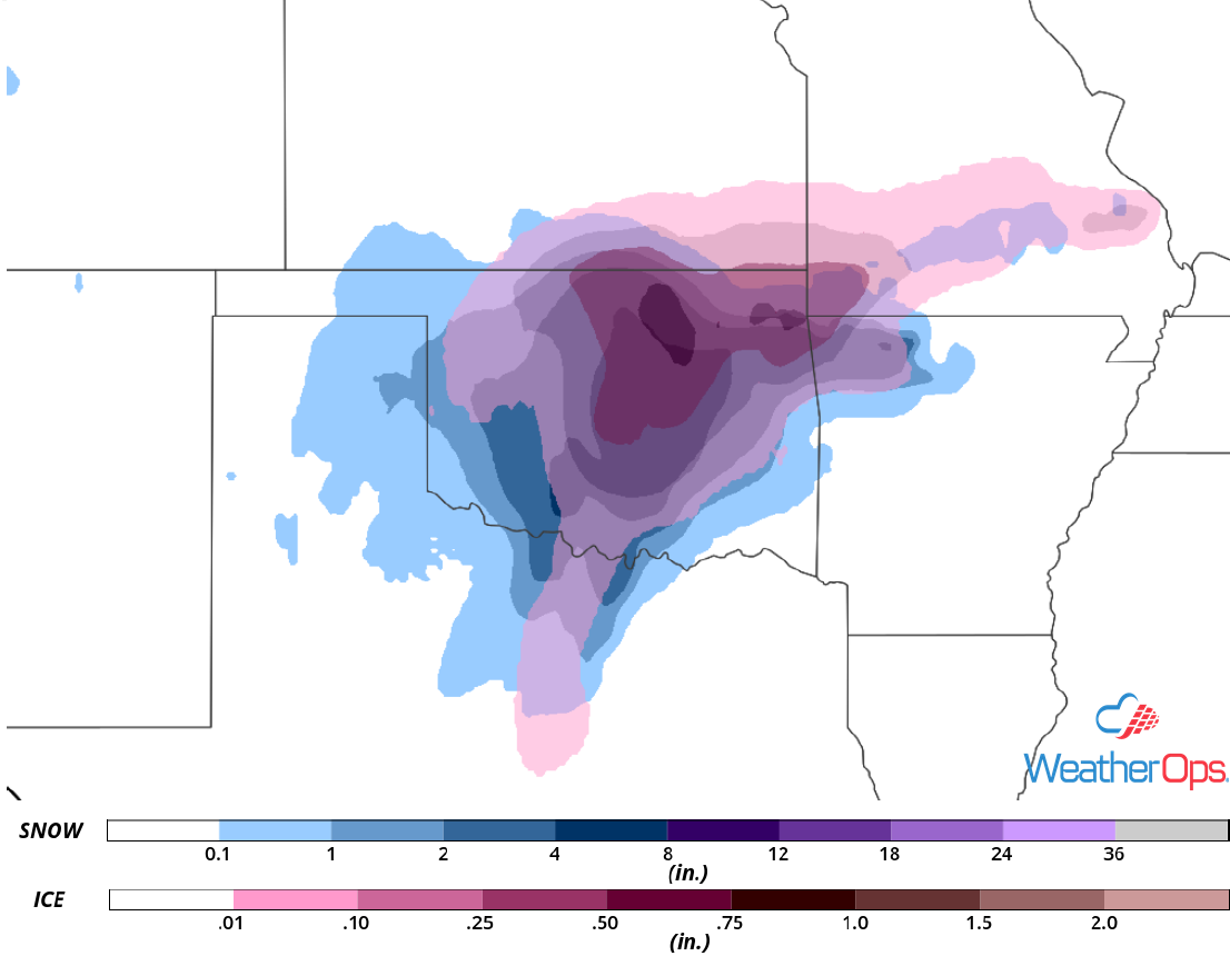
Snow and Ice Accumulation through Friday
Excessive Rainfall through Friday from the Lower Mississippi Valley into the Lower Tennessee Valley
A disturbance will continue to slowly move off to the east-northeast as an area of high pressure over the central US continues to slow its progression. Plentiful moisture in combination with the slow movement of this system will allow for training showers and thunderstorms across the region. This will result in widespread rainfall amounts of 2-3 inches on Thursday. As the system continues to slowly track to the east-northeast, it will begin to interact with another area of low pressure developing over Texas and Oklahoma, producing additional rainfall on Friday. Two day rainfall totals of 3-5 inches with locally higher amounts are expected. This will lead to a risk for flooding and flash flooding.
Major Cities in Region: Baton Rouge, LA, Jackson, MS, New Orleans, LA, Birmingham, AL, Atlanta, GA, Asheville, NC
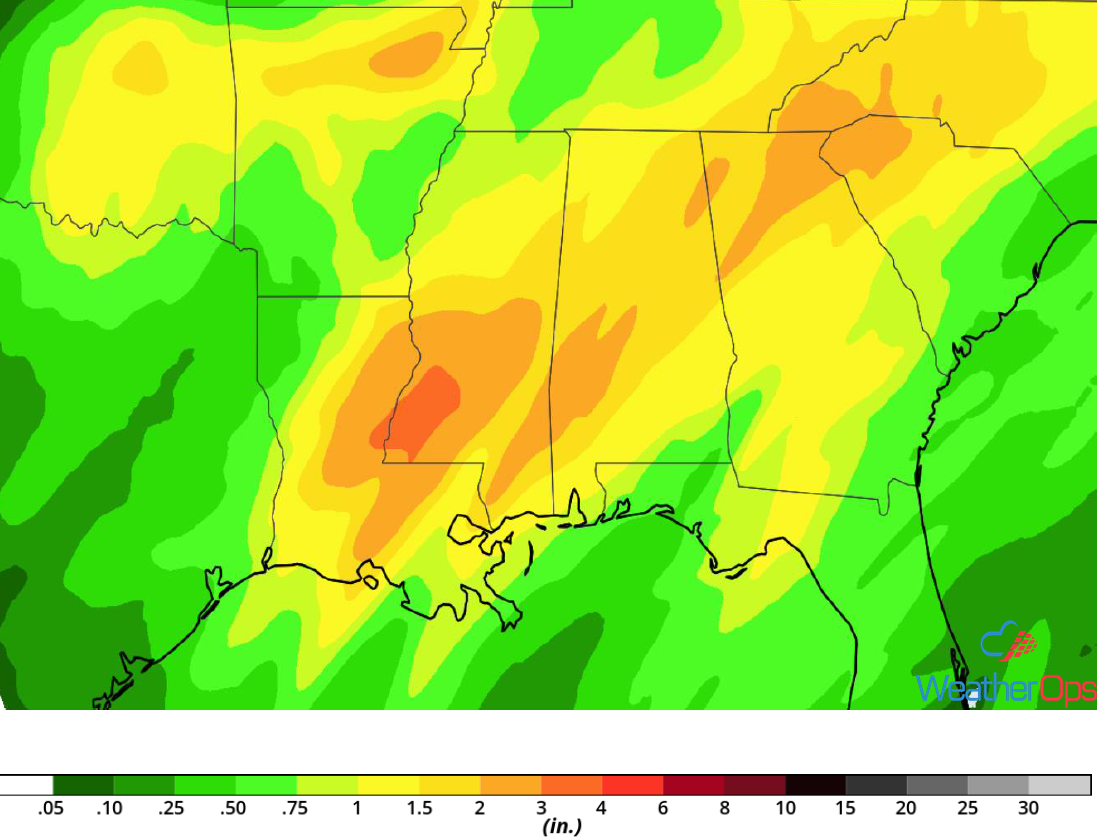
Rainfall Accumulation through Friday
Elevated Winds and Seas for the Northwestern Gulf of Mexico through Friday Evening
A cold front is currently stalled over the northwestern Gulf of Mexico. As an upper level low approaches, an associated surface low will develop along the front tonight and move northeastward. Northerly winds will then begin to increase and the front will start moving eastward. Winds ahead of the front will be from the south or southwest at 20-25 knots. Behind the front, winds will be northwesterly at 20-25 knots with gusts in excess of 35 knots. Seas will range 6-9 feet. Some strong to severe thunderstorms capable of producing enhanced winds and seas are also expected to develop ahead of the front.
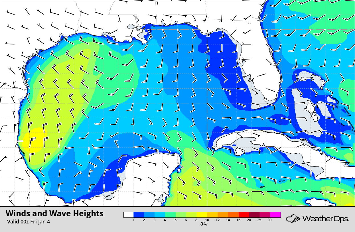
Winds and Wave Heights 6pm CST Thursday
A Look Ahead
Snow is expected Sunday across the Rockies as an area of low pressure moves eastward. Showers and thunderstorms may develop from the Great Lakes into the Plains on Monday ahead of a cold front. Light snow is forecast across the Upper Great Lakes. By Tuesday, snow will move into the Northeast in association with an area of low pressure. Rain and snow is forecast across the Sierra Nevadas on Wednesday as an upper level low approaches.
