


by David Moran, on Jan 24, 2019 10:40:14 AM
Thunderstorms will continue from Florida into the Carolinas on Thursday along and ahead of a cold front. Excessive rainfall is forecast across the Northeast as an area of low pressure moves eastward. Snow will continue across the Northeast through Thursday afternoon. An upper level trough will bring snow to the Great Lakes Thursday and Friday. Elevated winds and seas will continue across the Gulf of Mexico through Thursday afternoon.
- Thunderstorms from Florida into the Carolinas on Thursday
- Excessive Rainfall Thursday for the Northeast
- Continued Snow for the Northeast through Thursday Afternoon
- Snow Thursday and Friday across Michigan
- Elevated Winds and Seas across the Gulf of Mexico through Thursday Afternoon
- Snow Saturday and Sunday for the Northern Plains
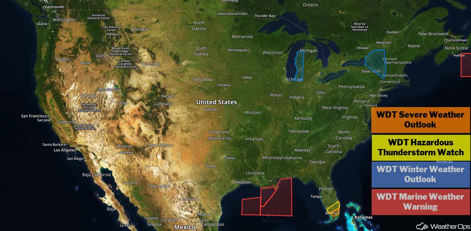
US Hazards
Thunderstorms from Florida into the Carolinas on Thursday
Strong to severe thunderstorms are ongoing across central and northern Florida as a cold front moves eastward. With strong wind shear and marginal instability, this activity is forecast to maintain strength or intensify later in the day. This will bring scattered strong to severe thunderstorms to portions of Florida into the Carolinas today. Damaging winds and isolated tornadoes will be the primary hazards within the stronger storms. The threat will end this afternoon and evening as the front pushes offshore.
Major Cities in Region: Tampa, FL, Orlando, FL, Wilmington, NC
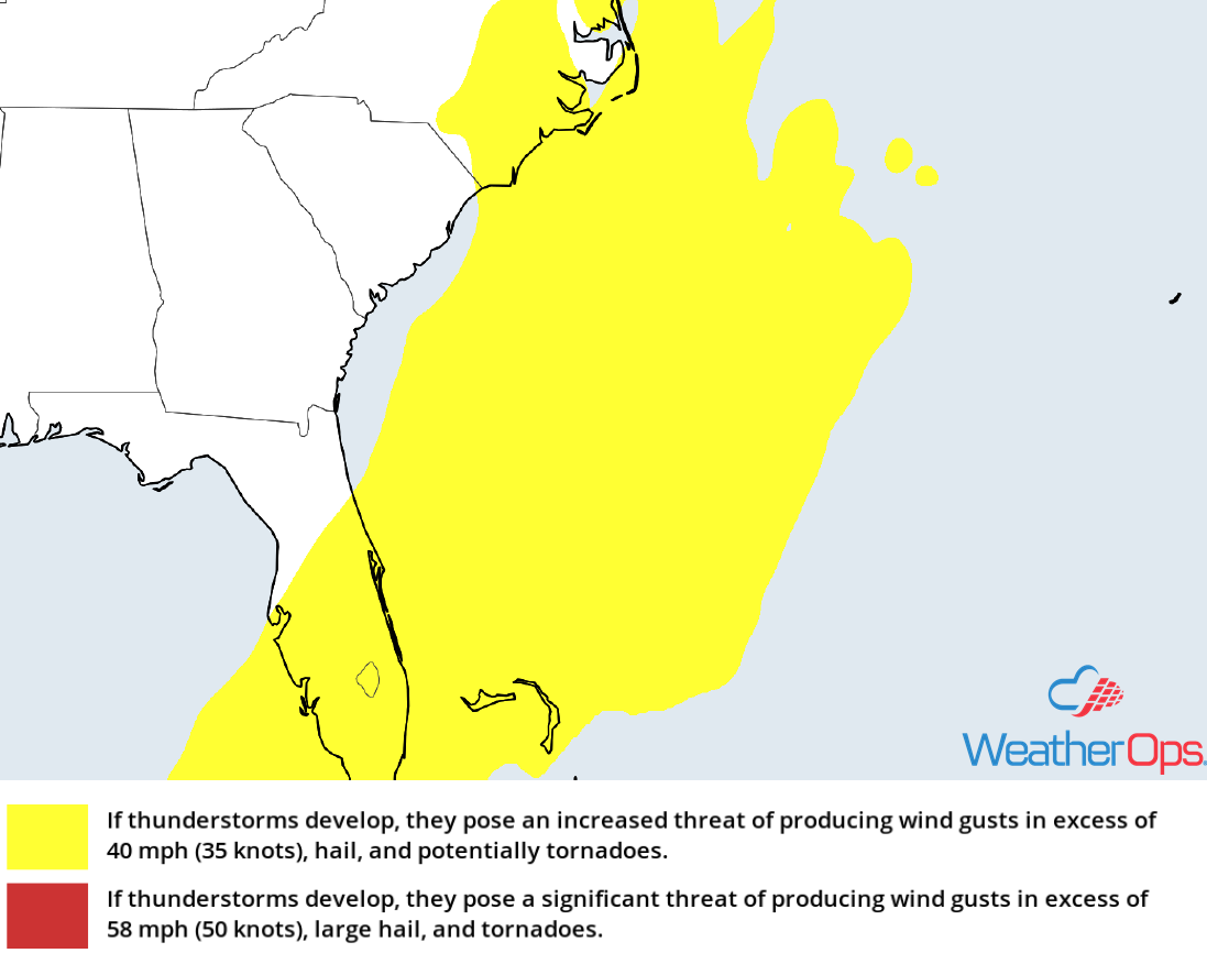
Thunderstorm Risk for Thursday
Excessive Rainfall Thursday for the Northeast
An area of low pressure and its associated cold front are forecast to continue track eastward across the Eastern Seaboard today. The frontal boundary is already bringing moderate to heavy rainfall to portions of the Northeast as it continues to slowly track eastward. Ahead of the cold front, strong southerly flow has continued to pump moisture northward across portions of the Mid Atlantic to Northeast. With this moisture in place and this cold front providing ample lift, this moderate to heavy rainfall is forecast to slowly move eastward today. Given the slow movement of this activity, heavy to excessive rainfall is forecast across the region today. Rainfall amounts of 1-2 inches with locally higher amounts in excess of 3 inches are forecast, leading to the potential for flash flooding and excessive runoff. This activity is forecast to move offshore later this evening.
Major Cities in Region: New York, NY, Burlington, VT, Bangor, ME, Augusta, ME
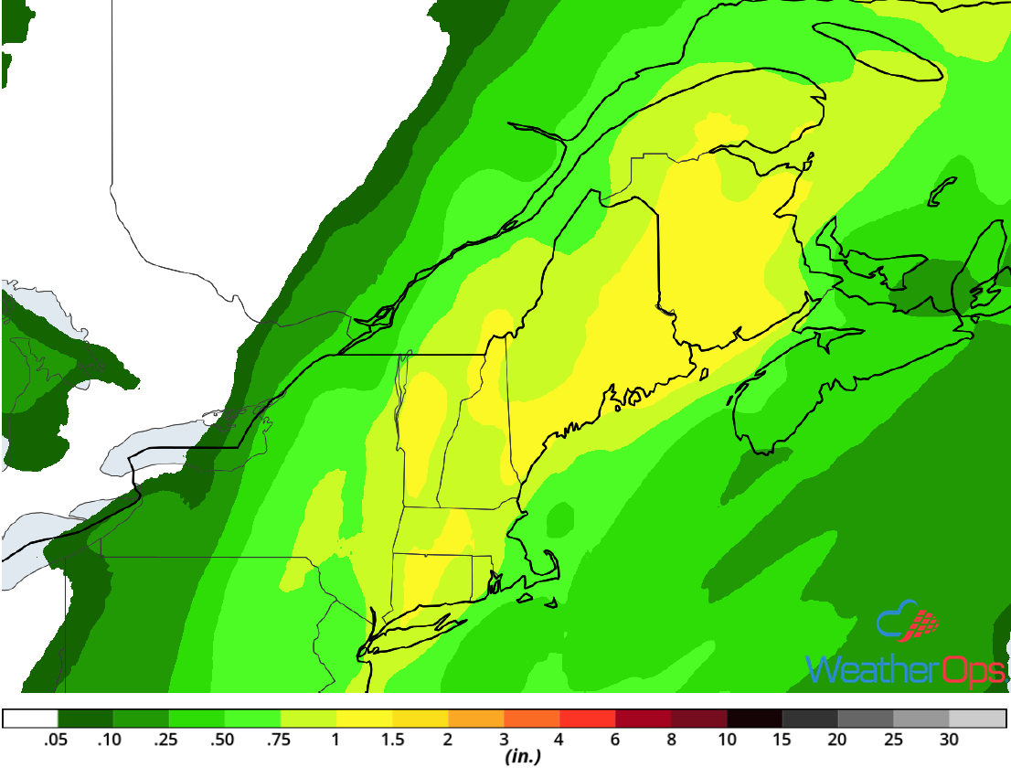
Rainfall Accumulation for Thursday
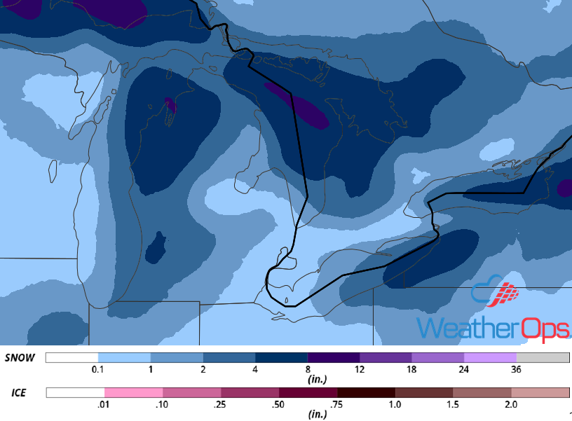
Continued Snow for the Northeast through Thursday Afternoon
Light snow is expected to continue across portions of the Northeast through the afternoon as an area of low pressure moves eastward. Snowfall accumulations will range 2-4 inches with locally higher amounts in excess of 6 inches. In addition, winds in excess of 40 mph will lead to blowing snow and hazardous road conditions.
Major Cities in Region: Pittsburgh, PA, Buffalo, NY, Rochester, NY, Syracuse, NY
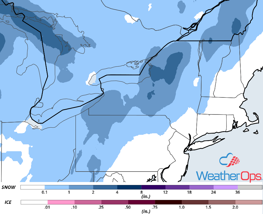
Snowfall Accumulation for Thursday
Snow Thursday and Friday across Michigan
A clipper system is forecast to track across the Great Lakes on Thursday and Friday. As this occurs, cold air and ample low level moisture is forecast to result in snow showers across western Michigan beginning Thursday morning. These snow showers will continue into Friday and intensify. Snowfall totals south of Grand Rapids will range 2-4 inches; north of Grand Rapids, 3-6 inches are expected. In addition, cold temperatures and wind gusts in excess of 20 mph will result in wind chills between 0 and -10°F. Snowfall should end Friday morning as the system moves out of the region.
Major Cities in Region: Grand Rapids, MI
Snowfall Accumulation through Friday
Elevated Winds and Seas across the Gulf of Mexico through Thursday Afternoon
As a cold front continues to move eastward across the region, elevated winds and seas will continue through Thursday afternoon. Winds will become northerly at 15-20 knots during the late morning. Seas will fall below 7 feet by the late afternoon.
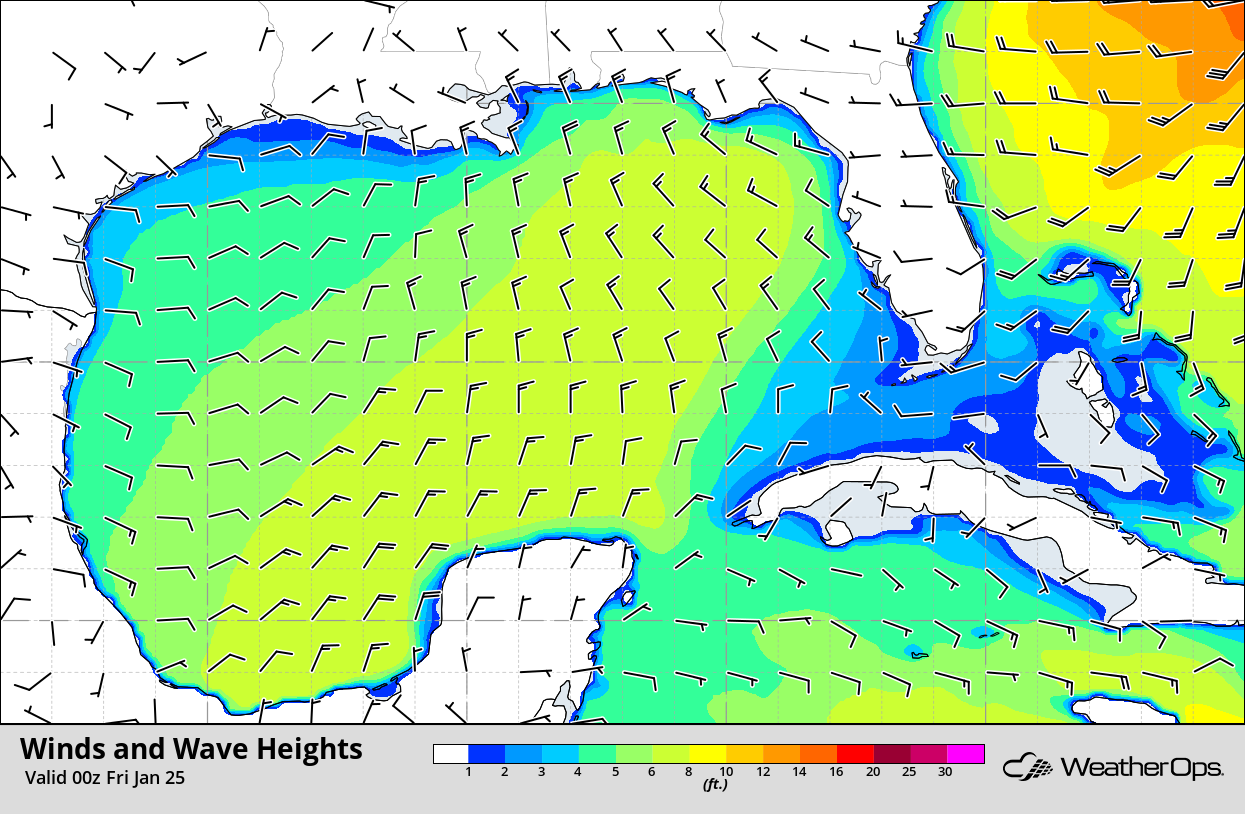
Winds and Waves 6pm CST Thursday
Snow Saturday and Sunday for the Northern Plains
A strong clipper system will track across the Northern Plains late Saturday into Sunday. This disturbance will bring ample moisture with it and with cold air in place, light snow will develop Saturday night into Sunday morning. Snow will increase in coverage throughout the morning hours on Sunday. Snowfall accumulations of 4-8 inches with locally higher amounts in excess of 10 inches are expected before snowfall ends late Sunday. In addition to the heavy snowfall, strong winds are also likely across the region, producing blowing and drifting snow. This will lead to hazardous travel conditions.
Major Cities in Region: Bismarck, ND, Grand Forks, ND, Sioux Falls, SD, Minneapolis, MN
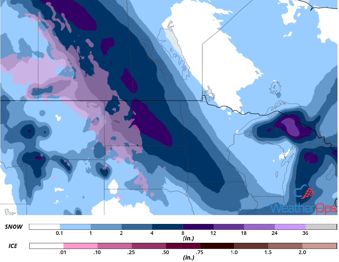
Snow Accumulation for Saturday and Sunday
A Look Ahead
The area of low pressure forecast to bring snow to the Northern Plains on Sunday will move eastward on Monday, producing snow across the Great Lakes. Late Monday into Tuesday, snow will move into the Northeast. Snow will persist across the Northeast on Wednesday.
