by David Moran, on Jan 17, 2019 11:06:43 AM
Excessive rainfall will continue across Southern California on Thursday as a cold front moves across the region. Snowfall will persist across the Sierra Nevadas as a series of low pressure systems move eastward. These systems will also bring snow to portions of the Rockies through Friday. Dense fog is expected along the Texas and Louisiana coasts through Friday morning.
- Excessive Rainfall across Southern California on Thursday
- Snow Thursday across the Sierra Nevadas
- Potential for Snow across the Rockies through Friday
- Dense Fog through Friday Morning along the Texas and Louisiana Coasts
- Thunderstorms from Central Texas into the Arklatex on Friday
- Snow Friday across the Northern and Central Plains and Midwest
- Potential for Thunderstorms along the Gulf Coast Saturday
- Excessive Rainfall Saturday for the Tennessee Valley
- Snow from the Midwest into the Ohio Valley on Saturday
- Potential for Snow Saturday and Sunday across the Northeast
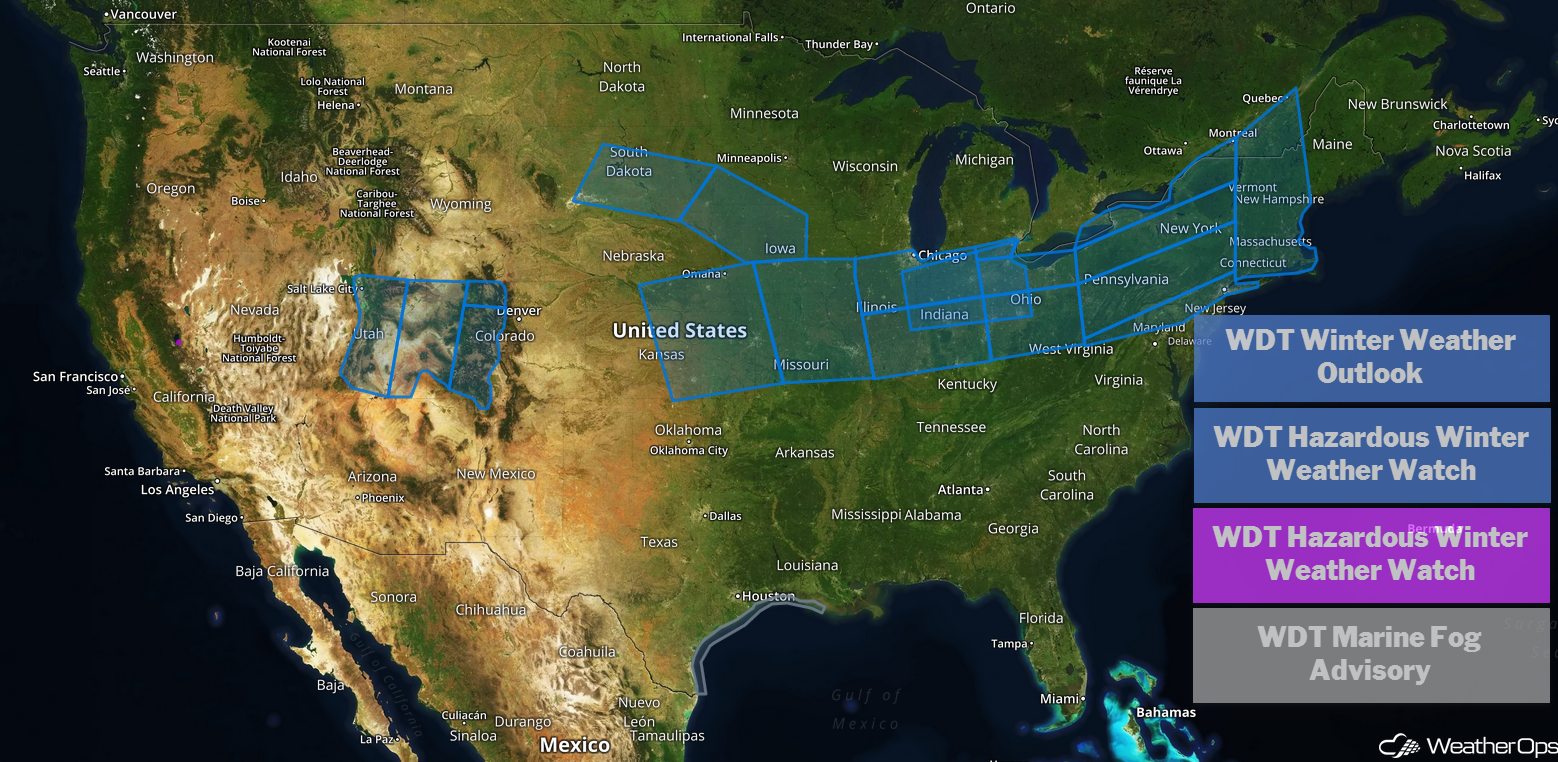
US Hazards
The threat for excessive rainfall leading to flooding will persist across portions of Southern California on Thursday. A cold front will slowly move through the region today, and scattered to widespread showers will continue through much of the day into the evening. Additional rainfall totals of 1-2 inches are expected over the lower elevations, with totals of 2-4 inches over the higher terrain and upslope areas of the Transverse Ranges. Shallow mud and debris flows may develop over recent burn scars. Isolated flash flooding and coastal flooding are likely.
Major Cities in Region: Los Angeles, CA
Rainfall Accumulation for Thursday
Heavy snowfall will continue across the Sierra Nevada Mountains as a series of low pressure systems move through the region. Moderate to heavy snow will persist through Thursday and begin to taper off Friday morning. An additional 1 to 2 feet of snow is expected today, accompanied by 50-70+ mph wind gusts. This will bring storm totals to 3-7 feet across the higher terrain and travel will be dangerous to impossible in the pass areas. The avalanche threat will be elevated, as well.
Major Cities in Region: South Lake Tahoe, CA
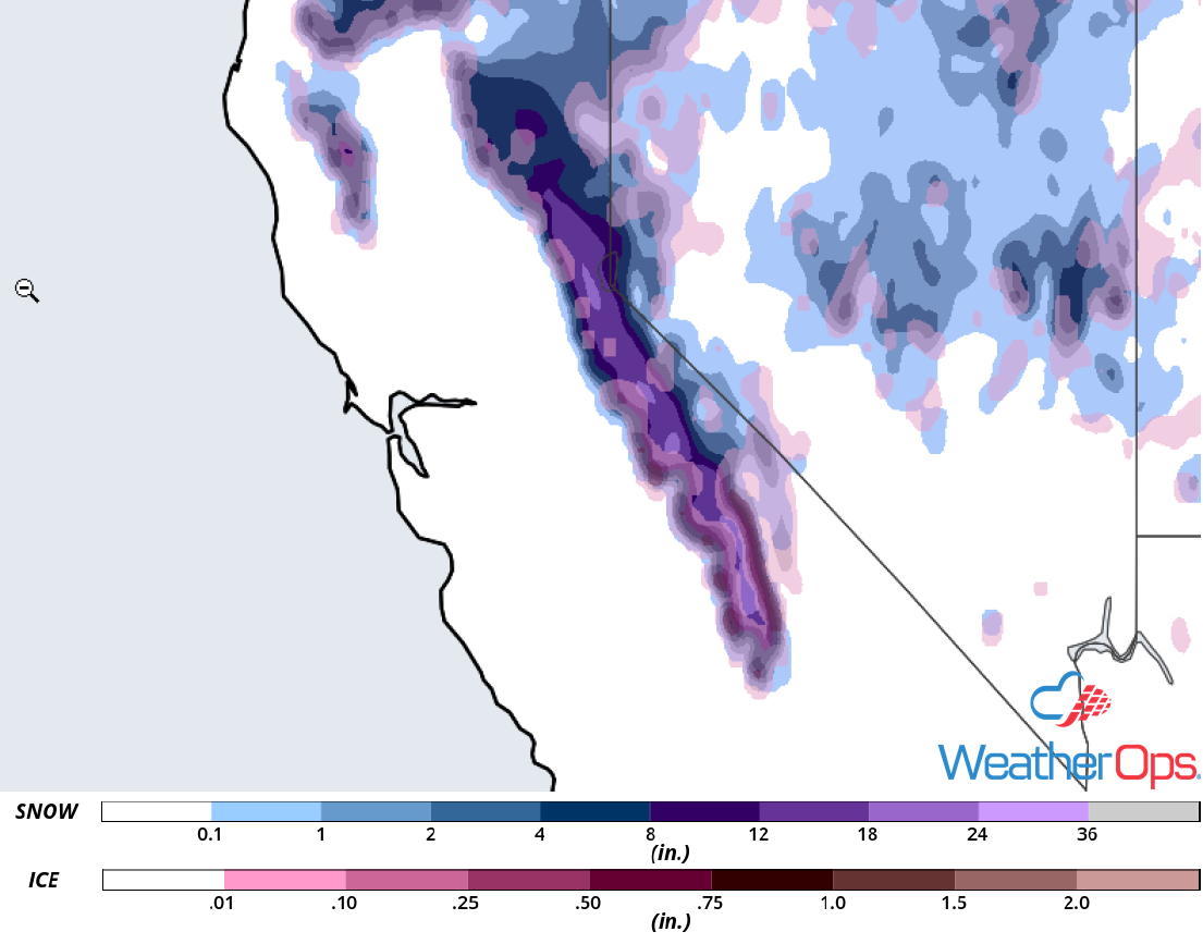
Snow Accumulation for Thursday
Potential for Snow across the Rockies through Friday
A large upper-level trough is currently moving onshore the West Coast this morning and will continue eastward through the Rocky Mountain region over the next two days. This will produce a threat for moderate to heavy snow over the higher terrain through Friday. Widespread amounts of 4-8 inches can be expected, with locally higher amounts in excess of a foot over the peaks. The valley areas are forecast to receive totals around 1-3 inches.
Major Cities in Region: Salt Lake City, UT, Grand Junction, CO
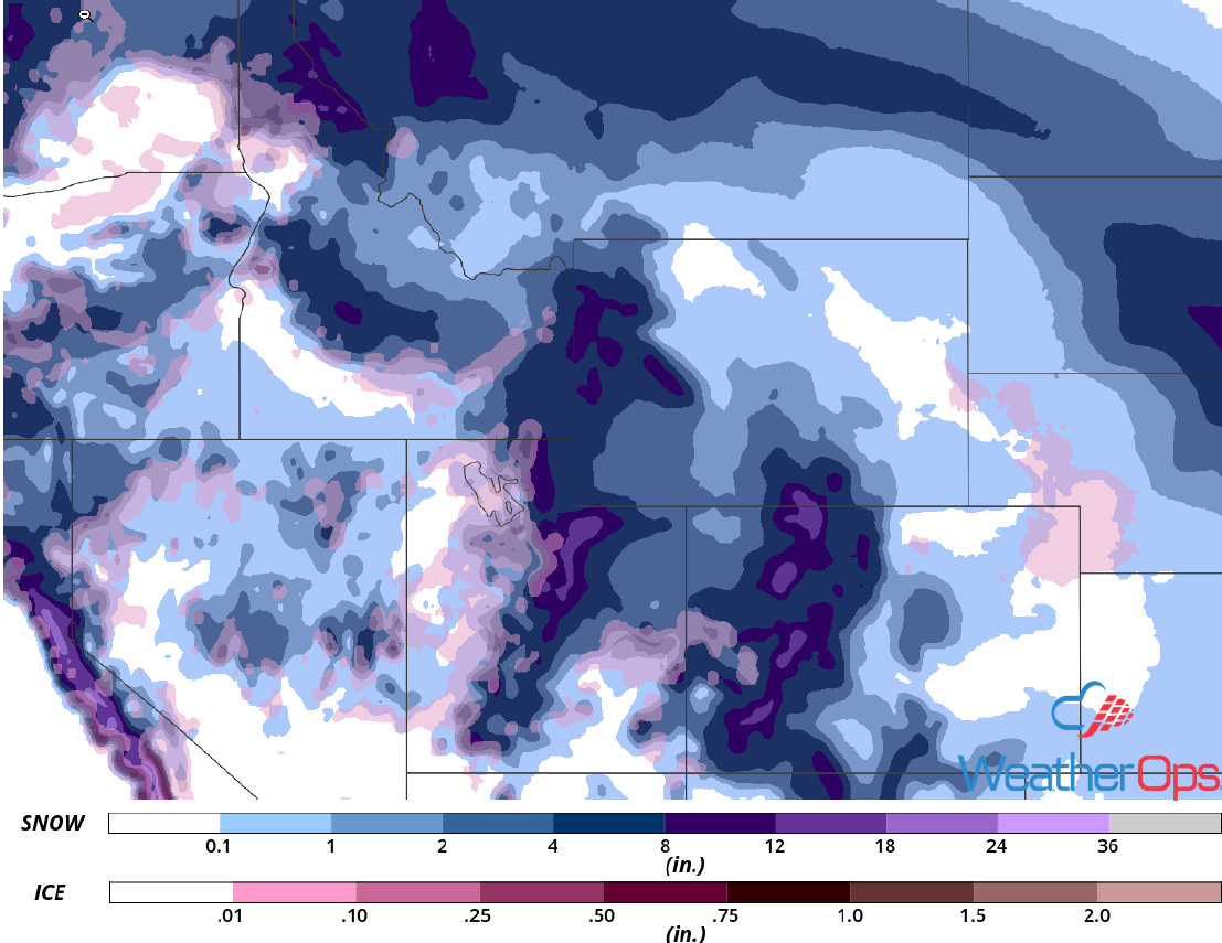
Snow Accumulation through Friday
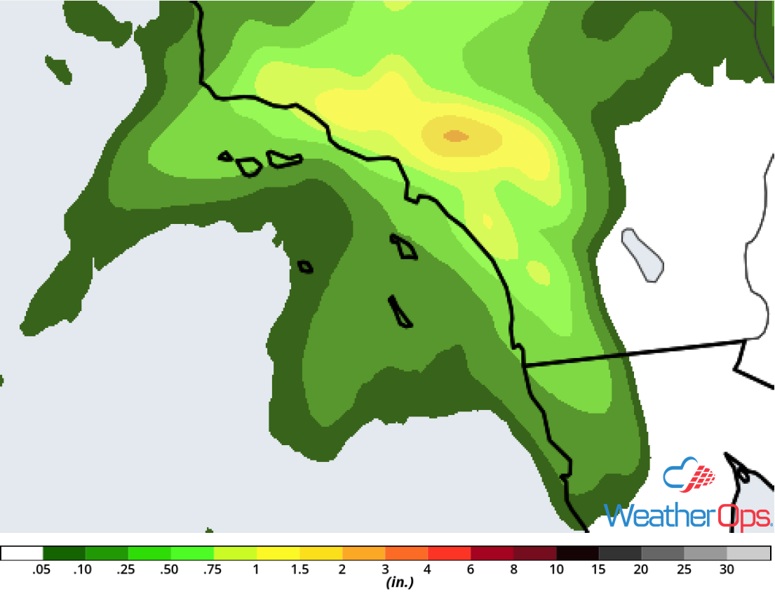
Dense Fog through Friday Morning along the Texas and Louisiana Coasts
Patchy dense fog will spread from the lower Texas coast to the north-northeast along the Louisiana coast through Friday morning. Visibilities will be less than two miles at times.
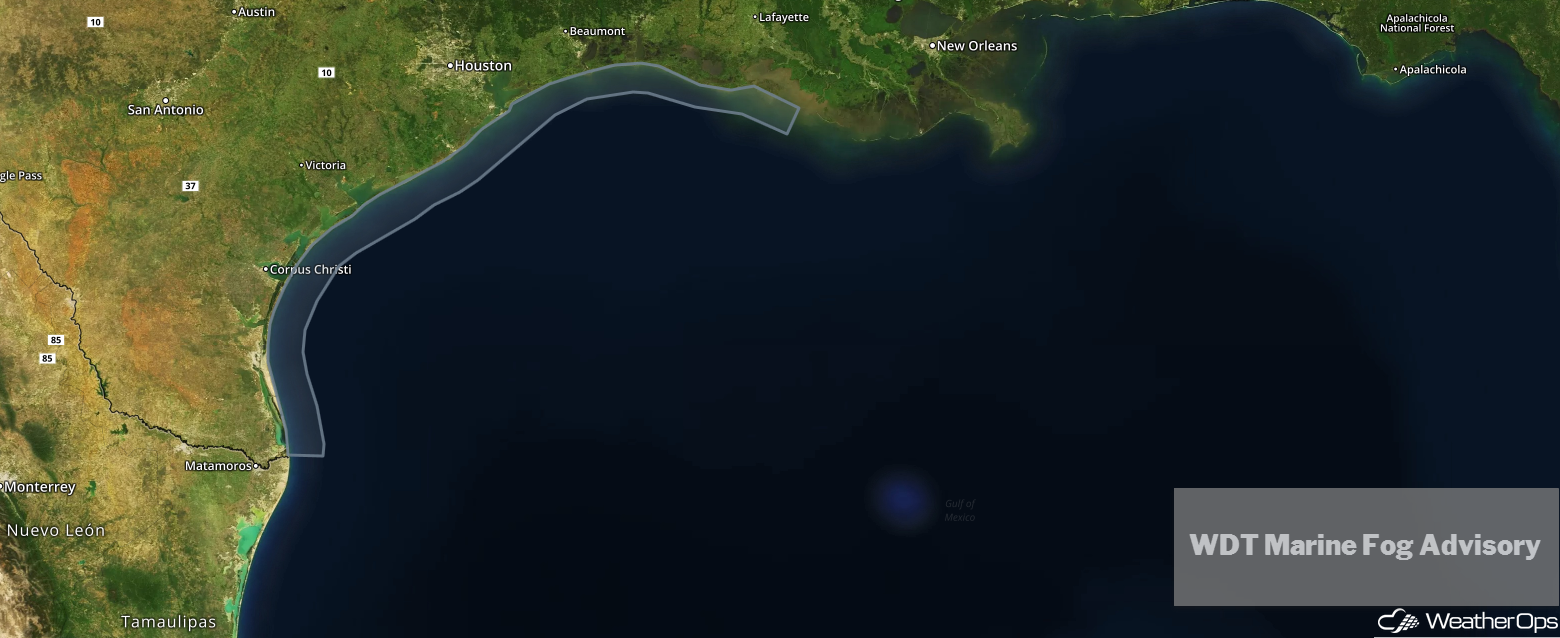
WDT Marine Fog Advisory
There will be a potential for strong to severe thunderstorms over portions of Northeast Texas into the Arklatex region on Friday. A low pressure system will strengthen over the Southern Plains during the day and warm, moist air will stream northward. Scattered thunderstorms could develop during the day, posing a risk for isolated strong/damaging wind gusts and large hail. Another round of storms may develop during the overnight hours as a cold front moves through the region. The primary hazard along the front will be damaging winds.
Major Cities in Region: Waco, TX, Dallas, TX, Shreveport, LA
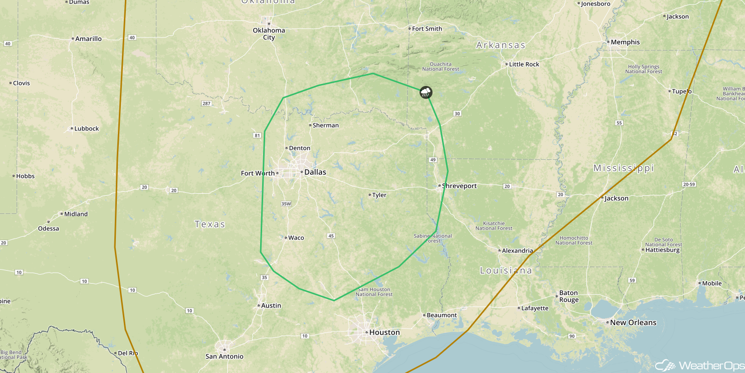
SPC Convective Outlook for Friday
Significant winter weather is forecast over portions of the Plains into the Midwest on Friday as an upper-level disturbance moves out of the northern Rockies into the Northern Plains. Forecast guidance shows a large area of moderate snow will move from northwest to southeast during the day and evening and will produce a large area of moderate snow accumulations in its wake. Widespread accumulations of 3-6 inches of snow are expected, with locally higher amounts in excess of 8 inches within heavier bands. As the snow tapers off Friday evening into Saturday morning, frigid cold wind chill temperatures will set in for the duration of the weekend.
Major Cities in Region: Pierre, SD, Sioux Falls, SD, Des Moines, IA
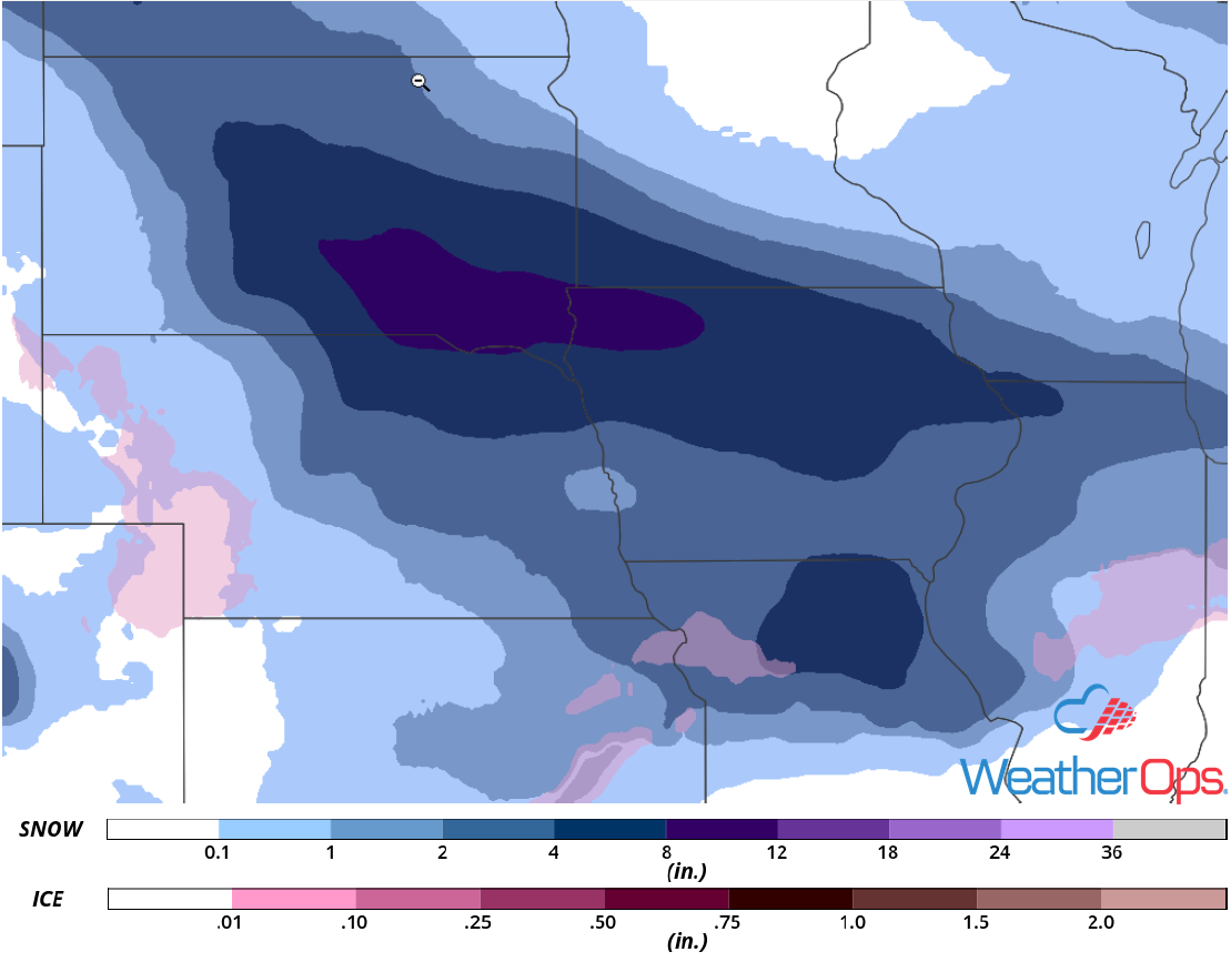
Snow Accumulation for Friday
The severe thunderstorm threat will shift into the Gulf Coast region on Saturday as a strong low pressure area moves through the Ohio Valley and a cold front pushes eastward through the region. Scattered to widespread showers and thunderstorms are expected near the front. Some storms will become strong or severe, especially by the afternoon hours when instability increases. The primary hazard will likely be strong/damaging wind gusts, however, an isolated tornado cannot be ruled out during the afternoon.
Major Cities in Region: Lafayette, LA, Baton Rouge, LA, New Orleans, LA, Jackson, MS, Mobile, AL, Pensacola, FL, Birmingham, AL
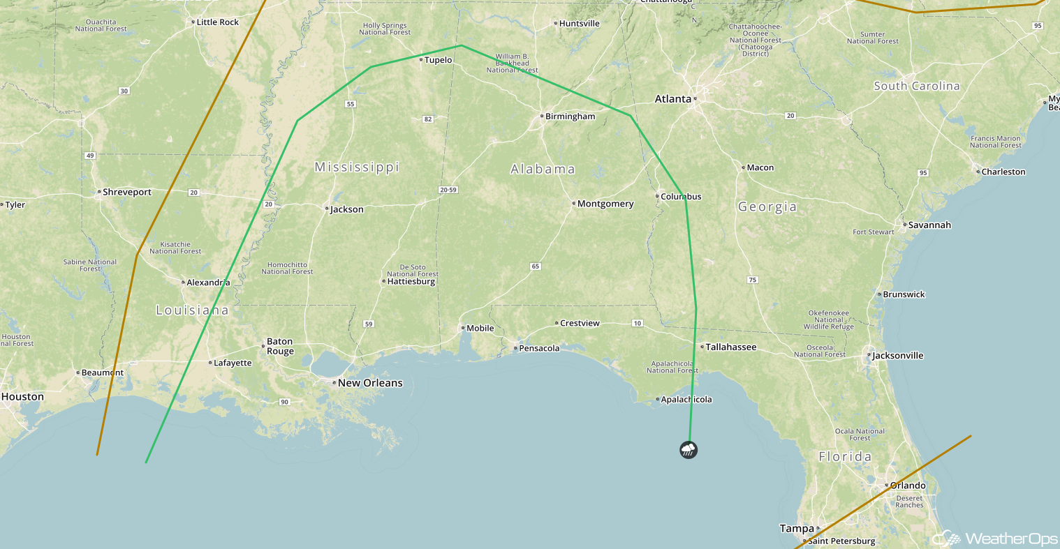
SPC Convective Outlook for Saturday
Excessive Rainfall Saturday for the Tennessee Valley
There will be potential for excessive rainfall leading to areas of flooding over portions of the Tennessee and Ohio Valleys on Saturday as a strong low pressure moves through the region. Ample moisture will be available with this system and rainfall will be widespread for the whole day. Localized heavy rainfall is expected near the associated cold front that will move eastward through the region. Rainfall totals of 1-3 inches, with locally higher amounts in excess of 3.50 inches, are forecast. The location of heaviest rainfall is uncertain at this time and will likely shift over the next day or two as the forecast guidance comes into better agreement.
Major Cities in Region: Nashville, TN, Lexington, KY
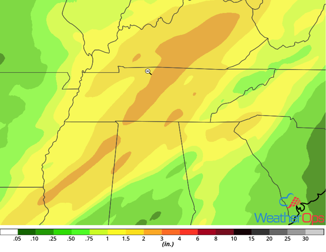
Rainfall Accumulation for Saturday
Snow from the Midwest into the Ohio Valley on Saturday
The winter storm potential will begin to increase significantly on Saturday as an area of low pressure intensifies while moving through the Ohio Valley. The low is forecast to leave a swath of 4 to 8 inches of snow across portions of southern Illinois into Indiana and Ohio, with both moderate snow and freezing rain across the Ohio River Valley. The low will be quick moving and snow will shift east of the region by early Sunday. Travel will likely become hazardous for much of the weekend.
Major Cities in Region: St. Louis, MO, Springfield, IL, Indianapolis, IN, Columbus, OH, Cleveland, OH
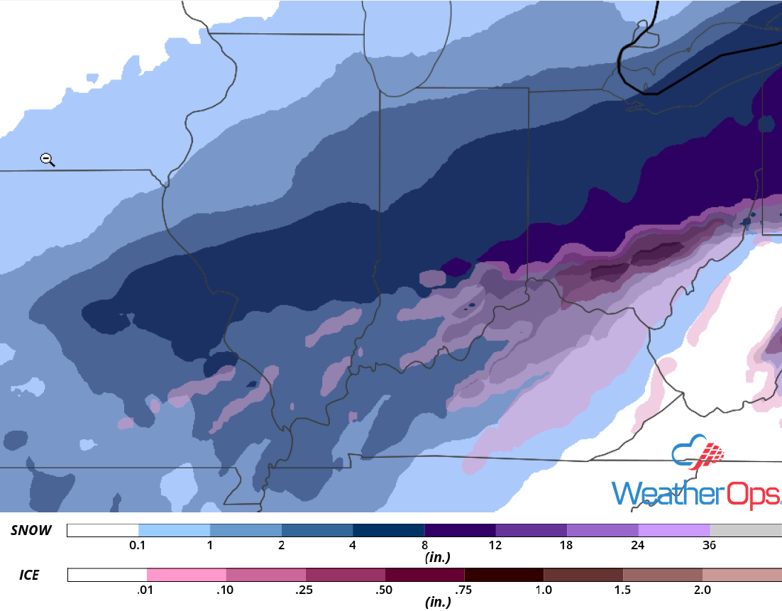
Snow Accumulation for Saturday
A potent winter storm will impact the Northeast starting late Saturday and persisting through Sunday. A surface low pressure area will curve northeast along the New England Coast on Sunday while strengthening, producing widespread moderate to heavy snow and significant freezing rain across the region. A large area of 1 to 2 feet of snow is forecast from Upper New York into Maine, with the snow totals to taper off to the north and south. Heavy wintry mix precipitation will be likely within the transition zone which is expected to set up along the coastal areas. There is uncertainty regarding the track of the low pressure, which will have a significant role in the location of heaviest ice/sleet totals. This winter storm will likely cause widespread travel impacts both on the ground and in the air, as well as power outages.
Major Cities in Region: Buffalo, NY, Albany, NY, New York, NY, Burlington, VT, Portland, ME
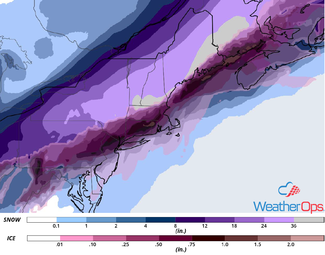
Snowfall Accumulation for Saturday and Sunday
A Look Ahead
Light snow is forecast across the Northern Plains and Upper Midwest on Sunday as a weak area of low pressure moves eastward. Snow may persist into Monday. Further west, snow is expected to develop across the Rockies as an upper level system moves across the region. By Tuesday, snow will extend from the Central Plains into the Great Lakes. As the system moves eastward, snow may develop from the Appalachians into the Northeast on Wednesday.