


by David Moran, on Feb 22, 2018 10:58:43 AM
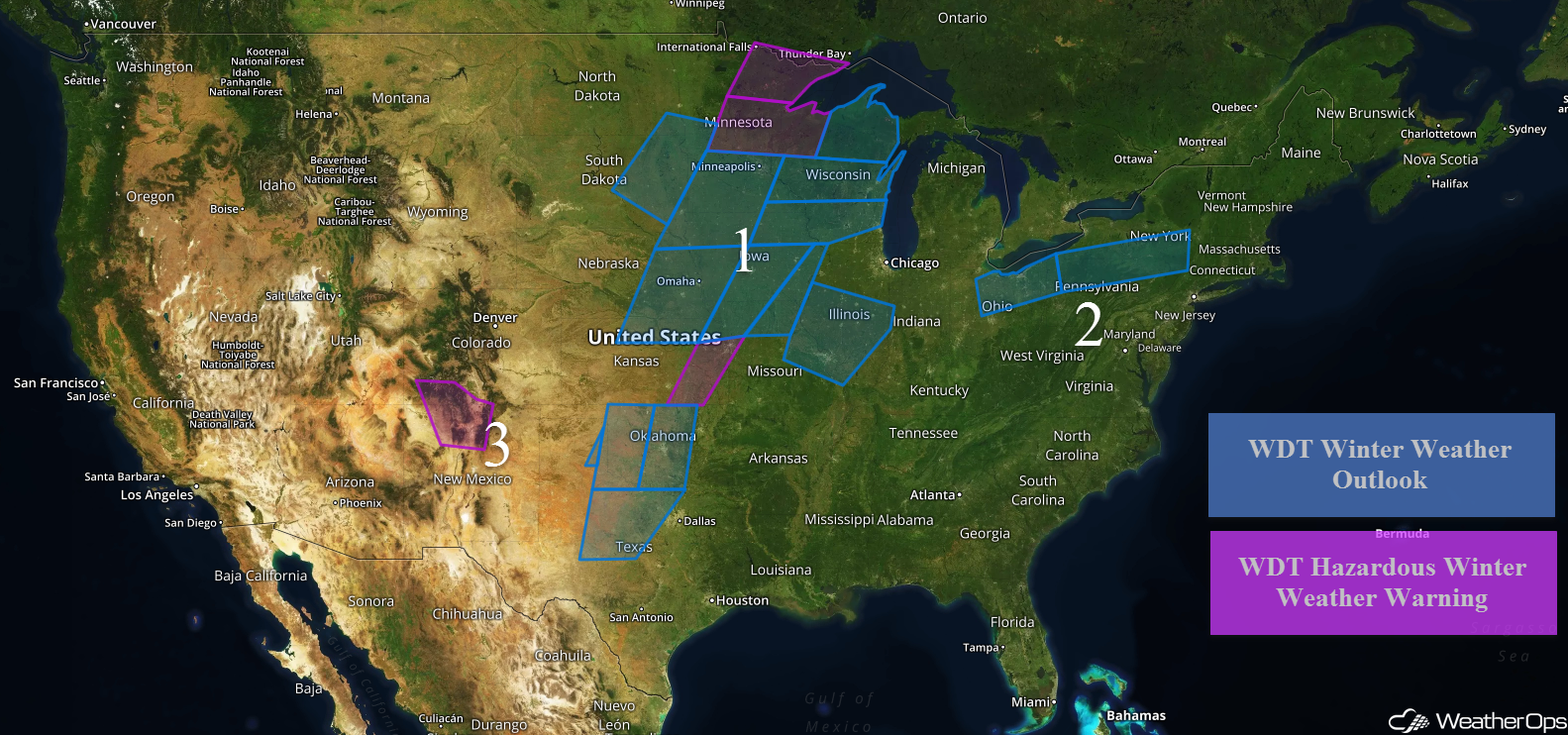
Freezing rain and snow will continue for portions of the Plains into the Great Lakes through Friday morning as an area of low pressure tracks northeastward. Light freezing rain will continue for portions of the Midwest and into the Northeast. Snow will continue for portions of Colorado and New Mexico as an area of low pressure slowly moves across the region. Excessive rainfall will continue from the Southern Plains into the Ohio Valley ahead of a cold front.
- Wintry Precipitation Continuing for the Plains into the Great Lakes through Friday Morning
- Freezing Rain Continuing Thursday from Ohio into New York
- Snow across Portions of Colorado and New Mexico Continuing Thursday
- Excessive Rainfall Continuing through Saturday from the Southern Plains into the Ohio Valley
- Thunderstorms from the Arklatex Region to the Tennessee River Valley on Saturday
- Snow Saturday from the Central Plains into the Midwest
 US Hazards

Wintry Precipitation Continuing for the Plains into the Great Lakes through Friday Morning
Southern Plains:
Freezing rain will continue for portions of Texas and Oklahoma through the morning hours on Thursday. Additional ice accumulations up to 0.20 inch are expected.
Central Plains:
Across eastern Kansas, additional ice accumulation up to 0.25 inch is expected, as well as sleet accumulations up to 0.50 inch through the morning. For portions of north central Kansas into central Nebraska, 1-3 inches of snow and light ice accumulations are forecast. Further east from northeastern Kansas to south central Iowa, 2-4 inches of snow with locally higher amounts are expected, in addition to up to 0.10 inch ice accumulation and 0.25 inch sleet accumulation. From northeast Missouri into east central Iowa, ice accumulations will range 0.05-0.15 inch. Across east central Missouri into southern Illinois, up to a tenth of an inch of ice is forecast.
Northern Plains:
From eastern South Dakota into southwestern Minnesota, snowfall accumulations will range 1-3 inches. Across extreme northeastern Nebraska into central Minnesota, 2-4 inches of snow with locally higher amounts in excess of 5 inches are expected. For northeastern Minnesota into northwestern Wisconsin, snowfall amounts will range 3-5 inches with locally higher amounts in excess of 6 inches. Across central and northeastern Wisconsin, 2-4 inches of snow are expected. From northeastern Iowa into southern Wisconsin, up to 2 inches of snow and a tenth of an inch of ice are forecast.
Major Cities in Region: Abilene, TX, Oklahoma City, OK, Omaha, NE, Kansas City, MO, Minneapolis, MN, Duluth, MN, Green Bay, WI, Milwaukee, WI
 Region 1
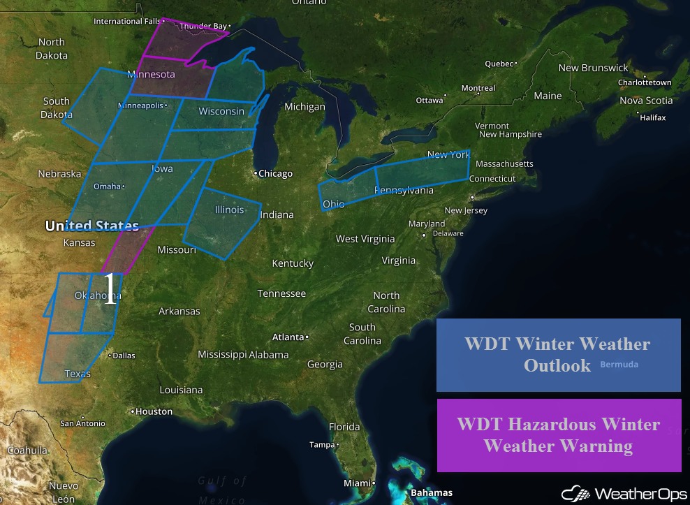
Freezing Rain Continuing Thursday from Ohio into New York
A light wintry mix will continue from Ohio eastward into New York through the day on Thursday. Ice accumulations will generally be less than a tenth of an inch. Snow accumulations of 1-2 inches are forecast from central Ohio to northwestern Pennsylvania and 2-4 inches across northern Pennsylvania and southern New York.
Major Cities in Region: Cleveland, OH, Binghamton, NY
 Region 2
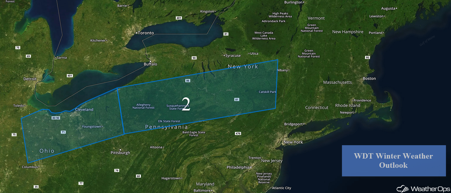
Snow across Portions of Colorado and New Mexico Continuing Thursday
Snow will continue for portions of New Mexico and Colorado as an area of low pressure slowly moves eastward. Accumulations of 1-4 inches are forecast in the lower elevations. For the higher elevations, 5-10 inches with locally higher amounts in excess of a foot are expected.
Major Cities in Region: Durango, CO, Santa Fe, NM
 Region 3
Excessive Rainfall Continuing through Saturday from the Southern Plains into the Ohio Valley
The risk for excessive rainfall will continue from the Southern Plains into the Ohio Valley through Saturday as a front remains nearly stationary over the region. Three day rainfall totals of 3-6 inches with locally higher amounts in excess of 8 inches are forecast, leading to the potential for flooding and flash flooding.
Major Cities in Region: Dallas, TX, Little Rock, AR, Memphis, TN, Louisville, KY, Cincinnati, OH, Pittsburgh, PA
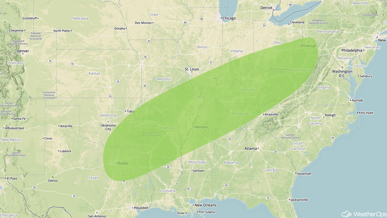 Excessive Rainfall Risk Outline for Thursday through Saturday
Thunderstorms from the Arklatex Region to the Tennessee River Valley on Saturday
There will be a potential for thunderstorms from the Arklatex region into the Tennessee Valley on Saturday. With strong shear and instability in place ahead of the front, thunderstorms may form. As thunderstorms develop, damaging winds will be the primary hazard, but a few tornadoes cannot be ruled out.
Major Cities in Region: Shreveport, LA, Little Rock, AR, Memphis, TN, Nashville, TN
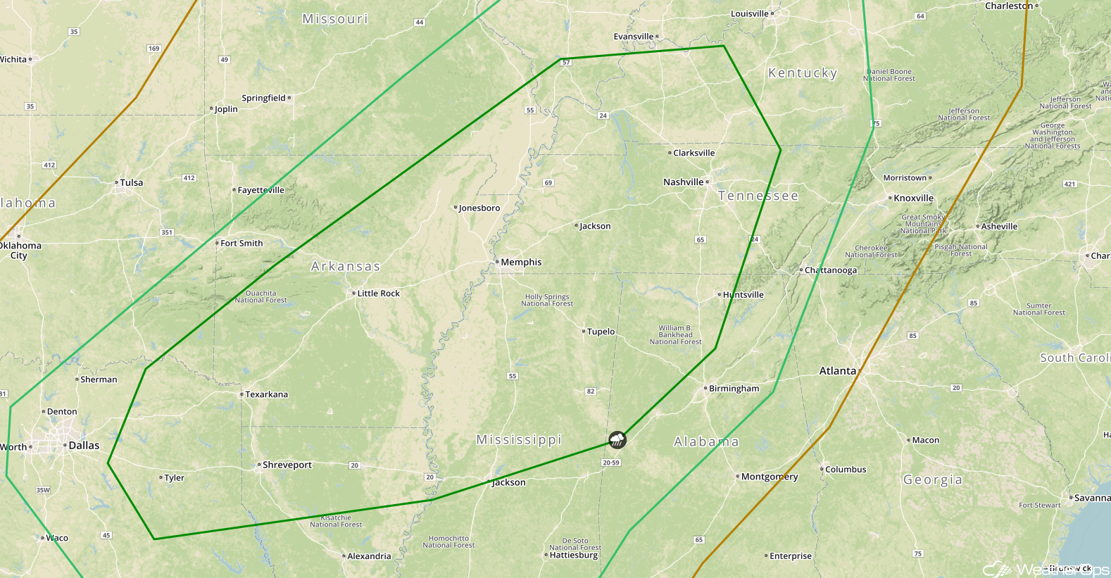 SPC Convective Outlook for Saturday
Snow Saturday from the Central Plains into the Midwest
Snow is forecast to develop on the northern periphery of the area of low pressure in the Central Plains described above. With cold air in place, there will be the potential for light to moderate (occasionally heavy) snow. Snowfall totals of 3-6 inches with locally higher amounts in excess of 8 inches are forecast.
Major Cities in Region: North Platte, NE, Sioux Falls, SD, Omaha, NE, Des Moines, IA, Minneapolis, MN, Duluth, MN
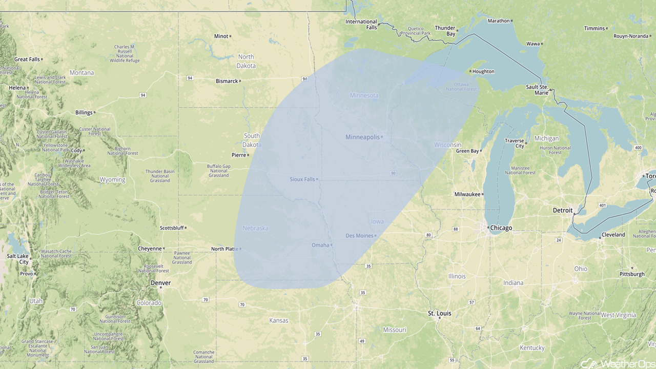 Snowfall Risk Outline for Saturday
A Look Ahead
A cold front is forecast to slow and eventually stall across the Deep South and southeast on Saturday. With ample moisture across the region, moderate to heavy rainfall is anticipated. Rainfall totals of 1-2 inches with locally higher amounts in excess of 3 inches are forecast, leading to a threat for excessive runoff and flash flooding.
That is a brief look at current weather hazards. We can provide you site-specific weather forecast information to protect your staff and assets and to assess your weather risk. Try a 7-day demo right away and learn how timely precision weather information can enhance your bottom line.
