National Weather Summary for Thursday, December 8, 2016
by David Moran, on Dec 8, 2016 11:10:28 AM
Lake effect snow is expected Thursday through Saturday morning as an area of low pressure moves northeastward into Ontario. Elevated winds and seas are expected Thursday into Friday across portions of the Gulf of Mexico ahead of a cold front. As an area of low pressure moves into the Pacific Northwest, heavy snow will be likely for portions of the Pacific Northwest and Northern Rockies beginning on Thursday and continuing through the weekend.
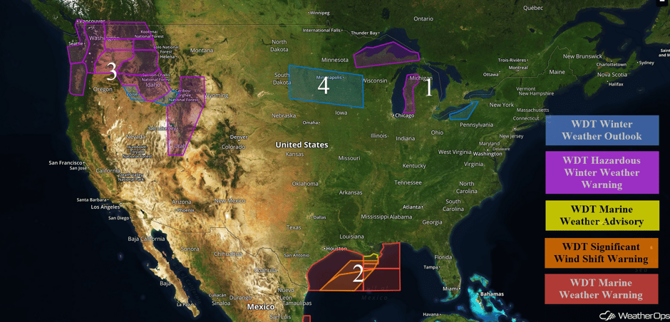 US Hazards
Region 1
Lake effect snow is expected to continue on the southern shore of Lake Superior through Friday morning. Widespread snowfall accumulations of 4-8 inches are expected for most of northwestern Wisconsin and the Upper Peninsula of Michigan. Where the heavier snow bands set up, accumulations could exceed a foot. Winds of 10-15 mph will lead to blowing snow, visibilities less than two miles, and wind chills in the single digits. Further east across western portions of the Lower Peninsula of Michigan, 4-8 inches of snow will be possible through late Friday. Snowfall rates could approach 1-2 inches per hour. Along the eastern shore of Lake Erie, snow will continue through Saturday afternoon. Accumulations of 4-6 inches with locally higher amounts in excess of 8 inches will be possible. Sustained winds of 15-25 mph with gusts in excess of 30 mph are expected.
Major Cities in Region: Marquette, MI, Grand Rapids, MI, Buffalo, NY
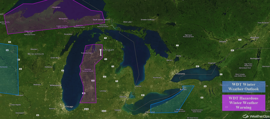 Region 1
Region 2
The strongest front of the season so far will impact the Gulf of Mexico Thursday and Friday. It is forecast to quickly move eastward, shifting winds from the east to southeast ahead of the front to the north or north-northeast behind the front. As the front passes, winds will increase from 10-15 knots ahead of the front to 30-40 knots with gusts in excess of 50 knots behind the front. Swells are expected to build to 8-12 feet in the wake of the front.
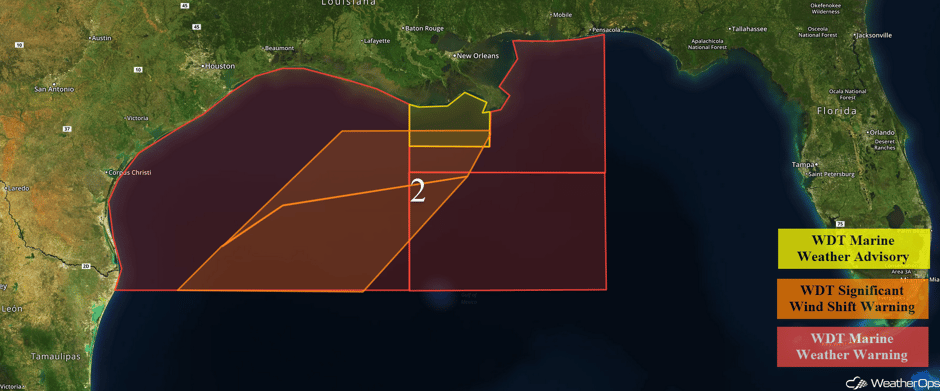 Region 2
Region 3
A strong area of low pressure remains on track to bring snow to much of far western Washington on Thursday into Friday. Below or near freezing temperatures are forecast as precipitation moves in from the south, with precipitation falling as snow throughout the region. Snow should continue into Friday morning with 3-6 inches of snow possible. Further east across eastern Washington and into Idaho, 6-12 inches of snow are expected in the valleys with 12-24 inches expected in the mountains. Snow accumulations of 6-9 inches with locally higher amounts in excess of 12 inches will be possible for portions of southeastern Idaho, western Wyoming, and Utah through Sunday. Some locally heavier amounts in excess of 20 inches will be possible.
Major Cities in Region: Portland, OR, Seattle, WA, Boise, ID, Missoula, MT, Salt Lake City, UT
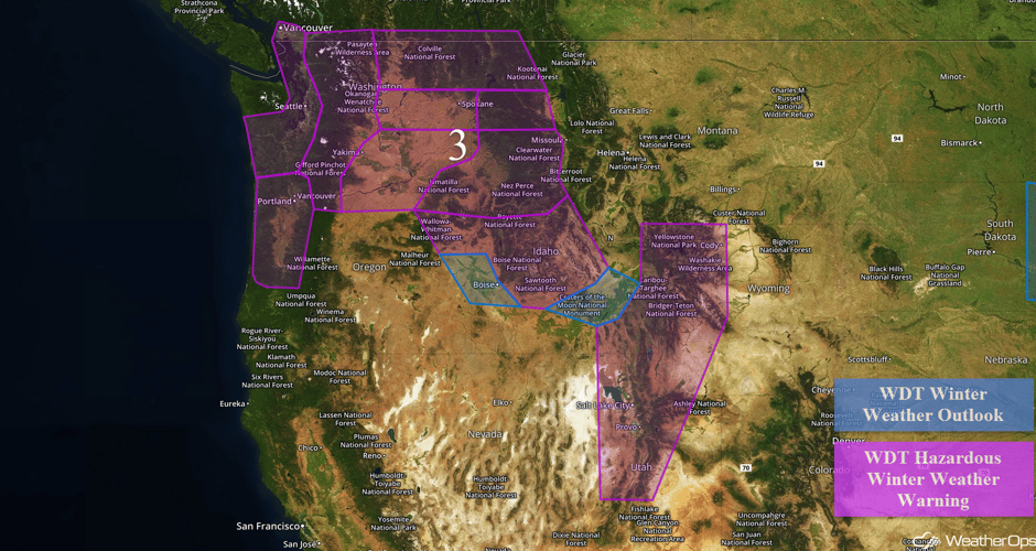 Region 3
Region 4
Heavy snow will be possible Saturday morning through Sunday across portions of South Dakota, Minnesota, Iowa, and Wisconsin. An area of low pressure is forecast to develop over eastern Wyoming and track east through the central Great Plains. Snow is expected to the north of this low, but there remains some uncertainty in where the heaviest snow will occur. Current information suggests that heavy snow will be possible from eastern South Dakota to western Wisconsin. Accumulations of 3-6 inches with isolated higher amounts in excess of 9 inches will be possible.
Major Cities in Region: Aberdeen, SD, Sioux Falls, SD, Minneapolis, MN, Rochester, MN
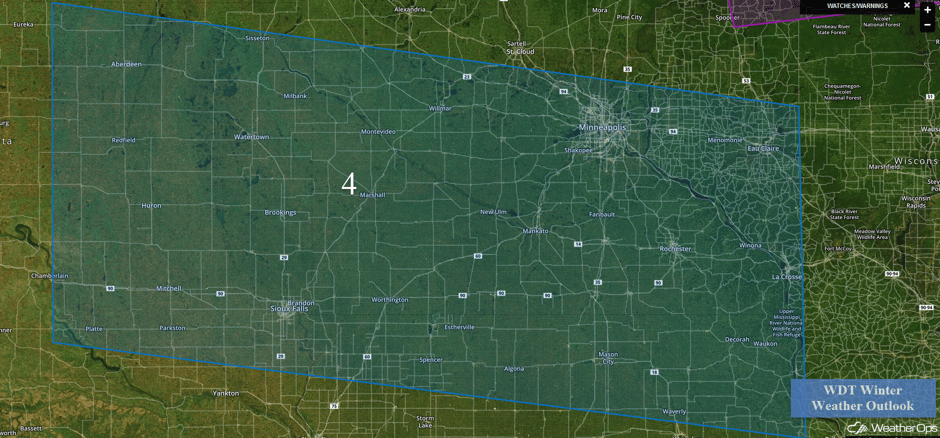 Region 4
A Look Ahead
An area of low pressure over the Plains will bring snow to portions of the Rust Belt into the Northeast on Sunday. Snow accumulations of 4-6 inches with isolated higher amounts in excess of 10 inches possible. As this low moves eastward, snow will continue across the Northeast on Monday with accumulations of 3-6 inches and locally higher amounts in excess of 10 inches. Heavy snow will continue across portions of Northern Idaho on Sunday. Accumulations of 4-8 inches will be likely above 4,000 feet with locally higher amounts in excess of 12 inches. Across the Cascades, an additional 8-12 inches of snow will be possible, bringing snow depths to 2-3 feet.
This is just a brief look at current weather hazards. We can provide you site-specific forecast information for the purpose of protecting your personnel and assets. Try a 7-day demo right away and learn how timely precision weather information can enhance your bottom line.


