


by David Moran, on Dec 6, 2018 10:50:32 AM
Lake effect snow will continue across western New York on Thursday as a disturbance moves across the region. A mixture of wintry precipitation is forecast across the Southern Plains and Lower Missouri Valley Friday and Saturday as an area of low pressure moves across Texas.
- Lake Effect Snow Thursday across Western New York
- Wintry Precipitation from the Southern Plains into the Lower Missouri Valley Friday and Saturday
- Thunderstorms Friday across South Texas
- Excessive Rainfall from Southeast Texas through the Arklatex on Friday
- Freezing Rain and Snow Saturday and Sunday from the Tennessee Valley through the Mid Atlantic
- Excessive Rainfall for the Gulf Coast States on Saturday
US Hazards
Lake Effect Snow Thursday across Western New York
Lake effect snowfall has developed and will continue this evening across portions of Lake Erie spreading eastward early on Thursday morning ahead of an approaching clipper system. Snow will increase in coverage and intensity across the region during the afternoon. Accumulations of 4-6 inches are expected but there will be the potential for locally higher amounts in excess of 8 inches depending on where the heaviest bands set up. Snowfall will end across the area Thursday evening as the clipper system moves into New England. In addition, winds may exceed 35 mph at times during the late morning and afternoon hours on Thursday. This will result in an increased risk for blowing and drifting snow, which will reduce visibility and create hazardous travel conditions across the region.
Major Cities in Region: Buffalo, NY
Snow Accumulation for Thursday
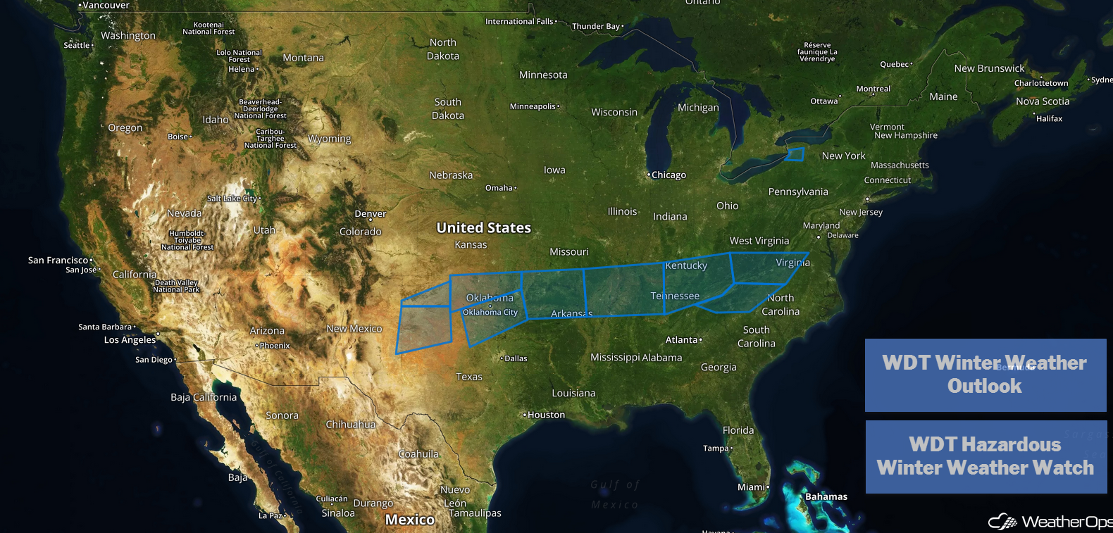
Wintry Precipitation from the Southern Plains into the Lower Missouri Valley Friday and Saturday
Significant winter precipitation is likely from the Southern Plains into the Lower Missouri Valley Friday into Saturday as an area of low pressure moves across Texas. A wintry mix is forecast from the Texas Panhandle into Arkansas and Missouri. Widespread snowfall accumulations of 3-6 inches with locally higher amounts in excess of 8 inches are forecast for the northern areas. Further south, snowfall accumulations will range from a dusting to a few inches. Across the southern areas, there will also be a mix of sleet and freezing rain. Accumulations could reach 0.50 inch.
Major Cities in Region: Amarillo, TX, Lawton, OK, Oklahoma City, OK, Fort Smith, AR, Little Rock, AR, Memphis, TN
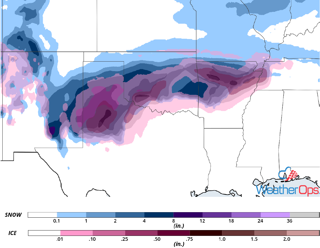
Snow and Ice Accumulation for Friday and Saturday
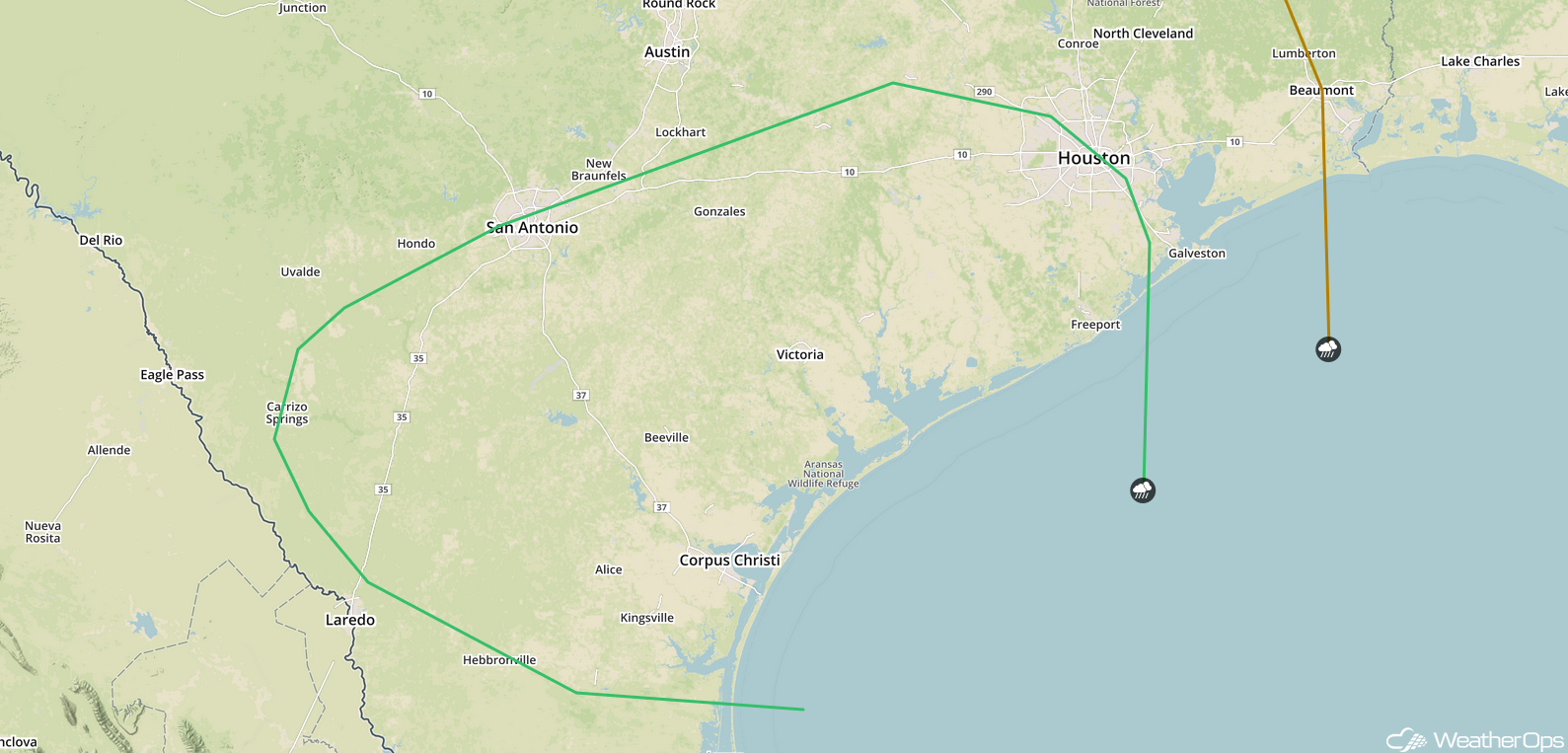
Thunderstorms Friday across South Texas
The area of low pressure described above will move southward, bringing a potential for widespread showers and thunderstorms, some which could be severe. Strong winds and large hail will be the primary hazards with these storms.
Major Cities in Region: San Antonio, TX, Victoria, TX, Corpus Christi, TX, Houston, TX
SPC Convective Outlook for Friday
Excessive Rainfall from Southeast Texas through the Arklatex on Friday
In addition to the thunderstorms described above, there will be a potential for excessive rainfall. Rainfall accumulations of 1-3 inches with locally higher amounts in excess of 4 inches are expected, particularly near San Antonio and Austin. This will result in a potential for widespread flooding and flash flooding.
Major Cities in Region: San Antonio, TX, Austin, TX, Corpus Christi, TX, Houston, TX, Shreveport, LA
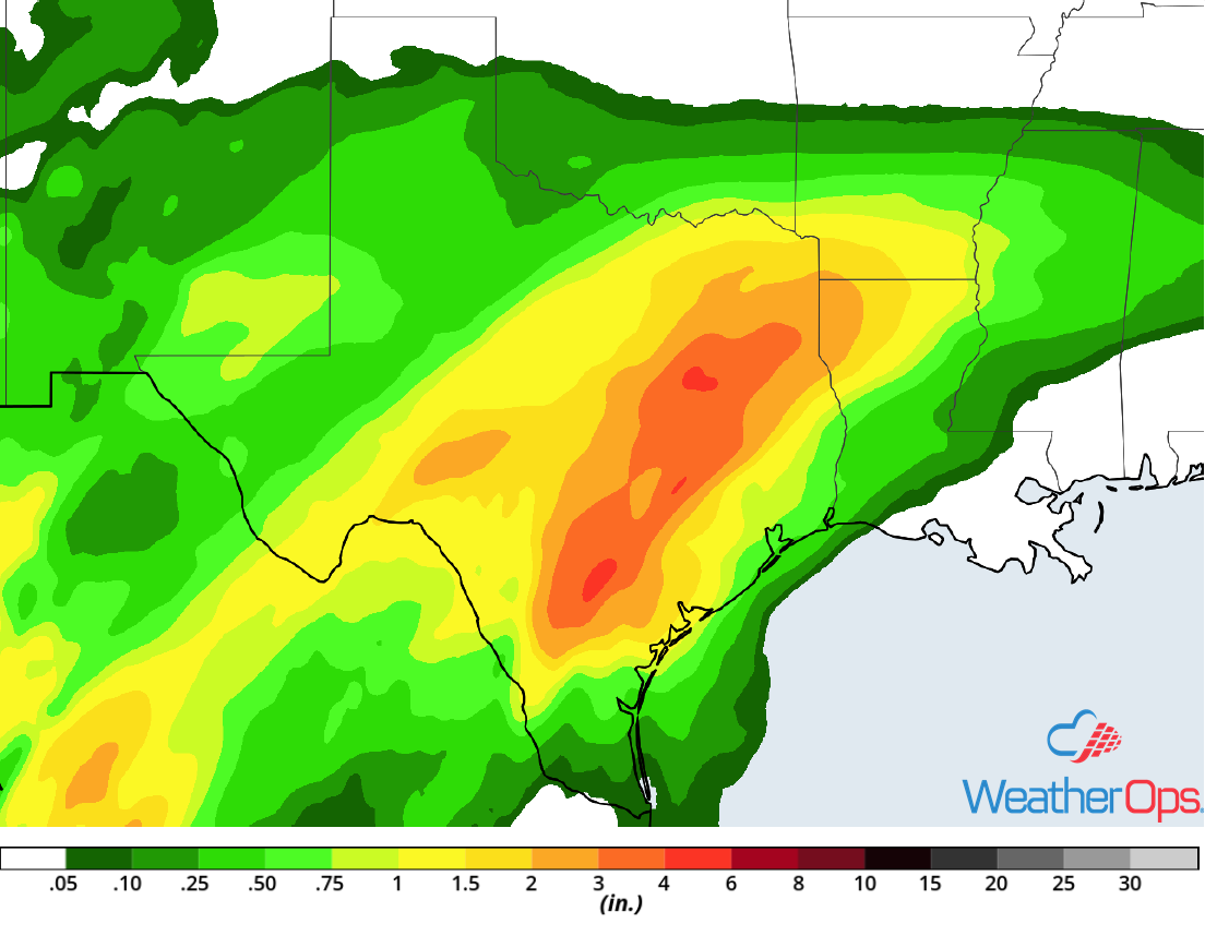
Rainfall Accumulation for Friday
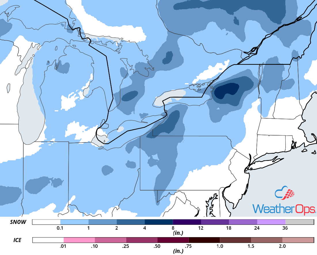
Freezing Rain and Snow Saturday and Sunday from the Tennessee Valley through the Mid Atlantic
As an area of low pressure moves across the Southeast over the weekend, wintry precipitation is expected across the Tennessee Valley and Mid Atlantic. Moderate to heavy snowfall is expected, particularly across the Appalachians, along with freezing rain and sleet as well. Accumulations exceeding a foot are likely for the mountains with lower elevations picking up 3-6 inches and locally higher amounts. Freezing rain accumulations will vary greatly, ranging from a glaze to 0.50 inch.
Major Cities in Region: Knoxville, TN, Blacksburg, VA, Columbia, SC, Raleigh, NC
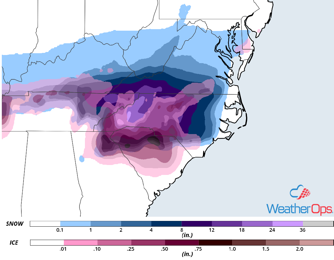
Freezing Rain and Snow Accumulation for Saturday and Sunday
Excessive Rainfall for the Gulf Coast States on Saturday
The area of low pressure across Texas described above will continue to move eastward on Saturday, bringing widespread rainfall to the Gulf Coast states. Rainfall accumulations will range 1-2 inches with locally higher amounts in excess of 3 inches expected. This may lead to areas of flooding and flash flooding.
Major Cities in Region: Shreveport, LA, Baton Rouge, LA, New Orleans, LA, Mobile, AL, Birmingham, AL, Atlanta, GA
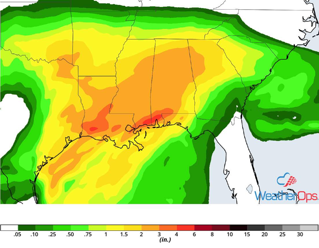
Rainfall Accumulation for Saturday
A Look Ahead
Freezing rain and snow may continue across the Appalachians and Carolinas on Monday as the area of low pressure described above continues to move northeastward. Light snow is forecast across the northern and central Rockies on Tuesday. By Wednesday, light rain and snow may develop across the Midwest and Central Plains.
