by David Moran, on Dec 27, 2018 10:40:37 AM
Thunderstorms will continue to track eastward from far southeast Texas into the Lower Mississippi Valley on Thursday ahead of a cold front. This cold front will bring the potential for excessive rainfall from portions of the Deep South into the Southeast. Snow will continue from the Great Plains into the Upper Midwest through Friday as an area of low pressure continues to track eastward. Elevated winds and seas are expected to continue across the Gulf of Mexico through early Friday morning ahead of a cold front.
- Thunderstorms from Southeast Texas into the Lower Mississippi Valley on Thursday
- Excessive Rainfall Thursday from the Deep South into the Southeast
- Snow from the Great Plains into the Upper Midwest through Friday
- Elevated Winds and Seas through Early Friday Morning across the Gulf of Mexico
- Excessive Rainfall for the Southeast on Friday
- Snow Friday and Saturday across Central New Mexico
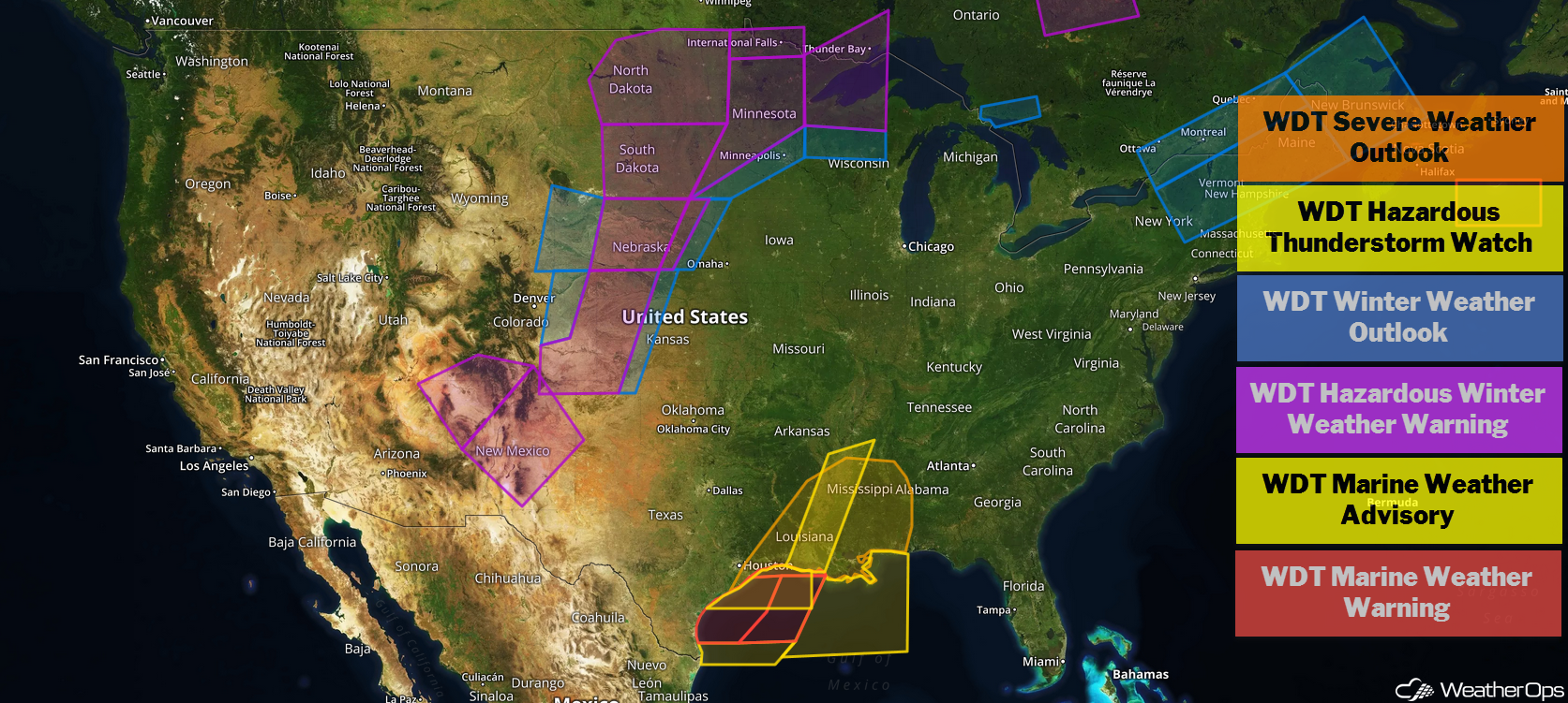
US Hazards
Thunderstorms from Southeast Texas into the Lower Mississippi Valley on Thursday
Ongoing strong to severe thunderstorms are expected to continue to track eastward across portions of southern Arkansas southward into southeastern Texas ahead of a cold front. This activity is forecast to continue tracking eastward across the Lower Mississippi Valley this afternoon and evening. With favorable conditions in place, some of these storms could remain strong to severe with damaging winds, hail, and isolated tornadoes as potential hazards. Some weakening may occur during the evening as the front stalls.
Major Cities in Region: Lafayette, LA, Baton Rouge, LA, New Orleans, LA, Jackson, MS, Mobile, AL
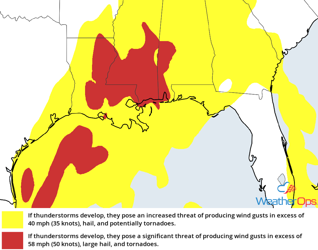
Thunderstorm Risk for Thursday
Excessive Rainfall Thursday from the Deep South into the Southeast
In addition to the thunderstorm potential described above, there will be a risk for excessive rainfall. Rainfall amounts of 2-4 inches with locally higher amounts in excess of 6 inches are expected. This will lead to an enhanced risk for flash flooding and local runoff.
Major Cities in Region: Baton Rouge, LA, New Orleans, LA, Mobile, AL, Birmingham, AL
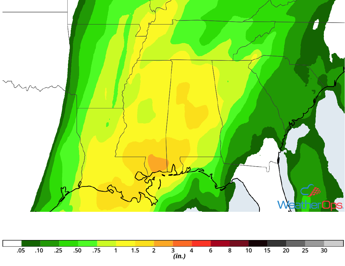
Rainfall Accumulation for Thursday
Snow from the Great Plains into the Upper Midwest through Friday
A strong winter storm continues to make its way northeastward across the Plains and Upper Midwest today. Periods of moderate to heavy snow are expected to persist across the region through Friday. Snow will increase in coverage and intensity from southwest to northeast this morning along the northern and western periphery of the low. Heavy snow will be the primary concern, but there will also be the potential for freezing rain. Snowfall accumulations will range 4-8 inches with locally higher amounts in excess of a foot. Ice accumulations will be less than 0.10 inch. Gusty winds are also likely across much of the region, leading to blizzard or near blizzard conditions.
Major Cities in Region: Goodland, KS, North Platte, NE, Grand Island, NE, Sioux Falls, SD, Minneapolis, MN, Duluth, MN
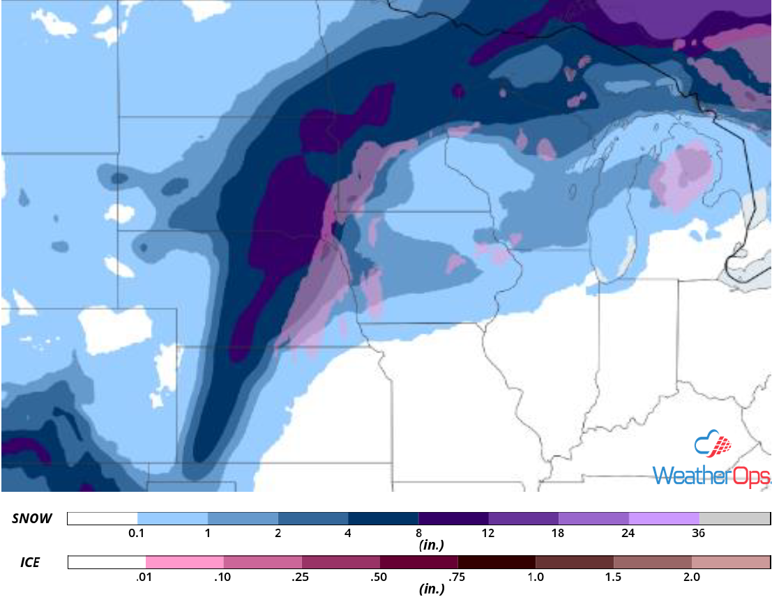
Snow and Ice Accumulation through Friday
Elevated Winds and Seas through Early Friday Morning across the Gulf of Mexico
A cold front moving across the Gulf of Mexico will lead to enhanced winds and seas across the region through early Friday. Winds will be southeasterly at 30-35 knots with gusts in excess of 45 knots. Seas will range 9-13 feet in western areas and 7-10 feet further east. In addition, thunderstorms will continue through early Thursday evening. Wind gusts in excess of 45 knots, waterspouts, heavy rain, and frequent lightning will be potential hazards with these storms.
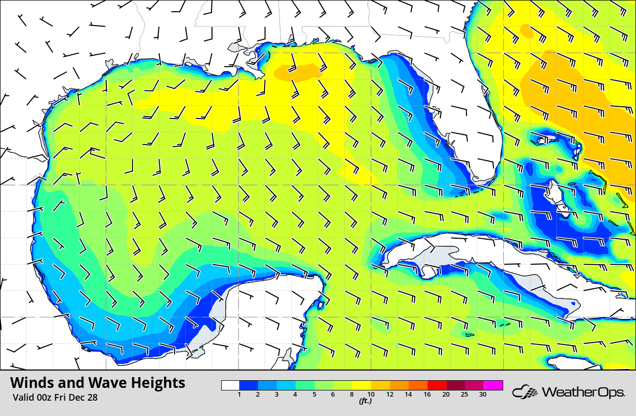
Winds and Wave Heights 6pm CST Thursday
Excessive Rainfall for the Southeast on Friday
The cold front described above will continue to move eastward on Friday. With plentiful moisture and the front providing lift, heavy rain and thunderstorms will likely be ongoing during the morning across portions of the Appalachians. Heavy rainfall and thunderstorms will continue to move eastward throughout the day. Rainfall amounts of 1-3 inches with locally higher amounts in excess of 4 inches are expected. This may lead to an increased risk for flooding and runoff over higher elevations.
Major Cities in Region: Tallahassee, FL, Knoxville, TN, Asheville, NC, Blacksburg, VA
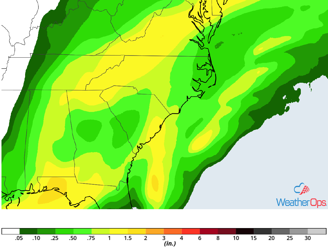
Rainfall Accumulation for Friday
Snow Friday and Saturday across Central New Mexico
An upper level disturbance is forecast to make its way into the Desert Southwest tomorrow, bringing a potential for moderate to heavy snow across portions of New Mexico Friday into Saturday. Light to moderate snowfall is forecast to overspread the region later this evening and increase in coverage and intensity on Friday, especially across the higher elevations. Widespread snowfall amounts of 4-8 inches with locally higher amounts are expected. In the higher elevations, snowfall totals will range 6-12 inches with locally higher amounts in excess of 15 inches.
Major Cities in Region: Albuquerque, NM, Santa Fe, NM, Roswell, NM
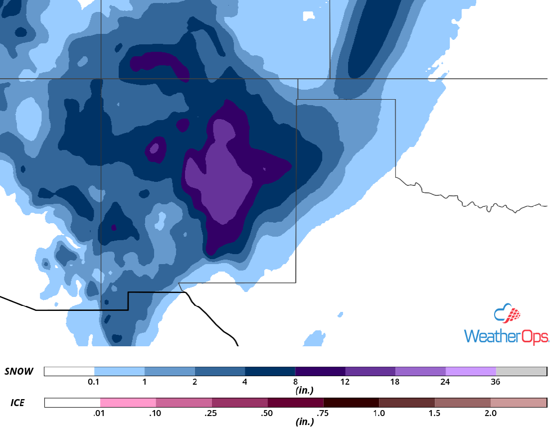
Snow Accumulation for Friday and Saturday
A Look Ahead
Snow is forecast across the Northern Rockies on Sunday as an upper level disturbance moves across the region. By Monday, snow will extend from the Northern Plains into the Great Lakes. An area of low pressure may develop over the Lower Mississippi Valley, bringing showers and thunderstorms from the Lower Mississippi Valley into the Ohio Valley on Monday. Light snow will move across the Great Lakes on Tuesday. Showers and thunderstorms may develop Wednesday across the Southeast.