National Weather Summary for Thursday, December 15, 2016
by David Moran, on Dec 15, 2016 11:23:45 AM
Wintry precipitation will continue across the Rockies on Thursday as an area of low pressure moves eastward. Activity will spread eastward into the Northern Plains, Great Lakes, and Northeast through the weekend. Widespread showers and thunderstorms are likely across portions of northern California ahead of a cold front on Thursday, bringing the potential for excessive rainfall. As the system bringing wintry precipitation moves eastward on Saturday, thunderstorms may develop across portions of the southern US.
 US Hazards
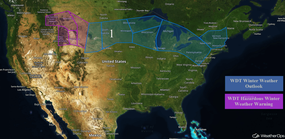
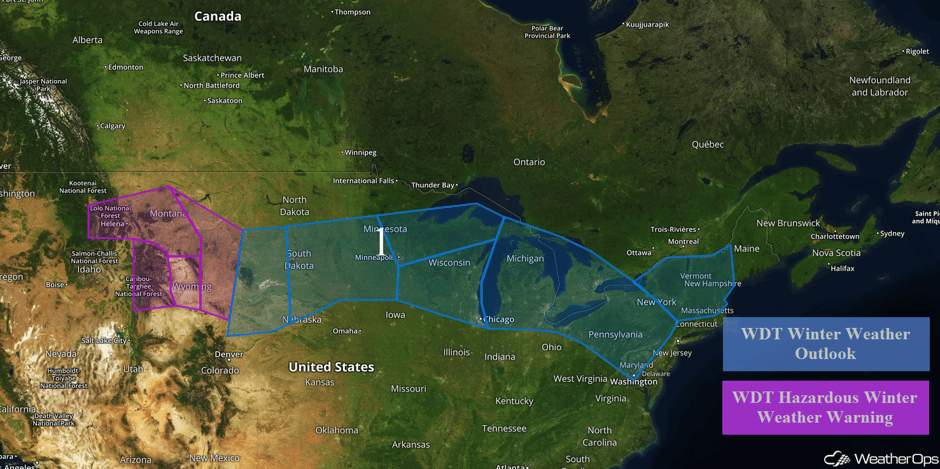
Region 1
Snow will continue across portions of the Northern Rockies as an area of low pressure moves across the region. Accumulations will generally be around a foot or less in the valleys and over 2 feet in the mountains. In addition, wind chills below -15F are expected late Friday into early Saturday. As the area of low pressure continues to move eastward, snow will begin across the Northern Plains Friday morning into early Saturday. Snow accumulations of 3-6 inches with locally higher amounts in excess of 8 inches will be possible. In addition, winds will range from 15-25 mph with gusts in excess of 30 mph, allowing for wind chills of -25 to -35. For portions of the Upper Midwest, snow accumulations of 1-3 inches with locally heavier amounts of 4 inches are forecast. Winds of 15-20 mph, with gusts in excess of 25 mph, will allow for visibilities of less than 2 miles at times. Across the western Great Lakes, snow accumulations of 5-6 inches, with locally higher amounts in excess of 8 inches, are expected through late Saturday. Into the eastern Great Lakes, snow accumulations of 3-8 inches, with locally higher amounts in excess of 10 inches, are expected through late Saturday. In addition to the snow, ice accumulations of a quarter of an inch with higher amounts from portions of Pennsylvania are forecast.
Major Cities in Region: Helena, MT, Jackson, WY, Rapid City, SD, Pierre, SD, Sioux Falls, SD, Minneapolis, MN, Milwaukee, WI, Chicago, IL, Detroit, MI, Cleveland, OH, Pittsburgh, PA, Washington, DC, Albany, NY, Boston, MA, Portland, ME
 Region 1
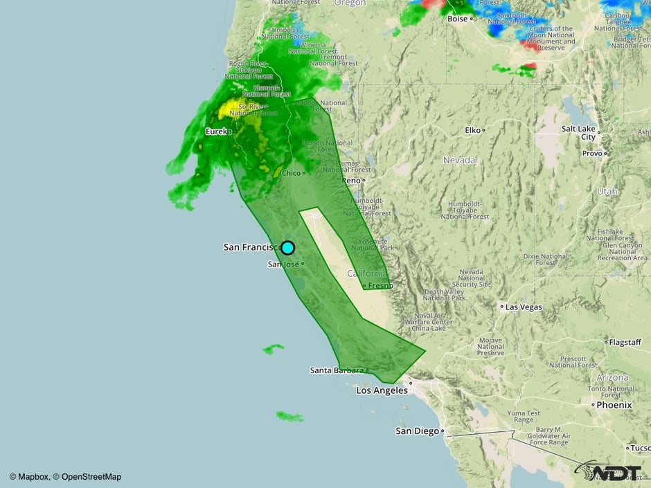
Excessive Rainfall Possible across Portions of California on Thursday
An area of low pressure and associated cold front will continue to move onshore across the western US and produce widespread rain and showers across much of coastal California, as well as the Sierra Nevada range and adjacent valley locations. With deep moisture in place, there will be a potential for excessive rainfall across the region. Rainfall amounts of 2-4 inches will be possible in many locations, however, a few areas may see over 6 inches, especially across the Sierra Nevada range. This rainfall may allow for an increased threat of flooding and runoff.
Major Cities in Region: Eureka, CA, San Francisco, CA, Santa Barbara, CA, Chico, CA
 Excessive Rainfall Risk Outline for Thursday
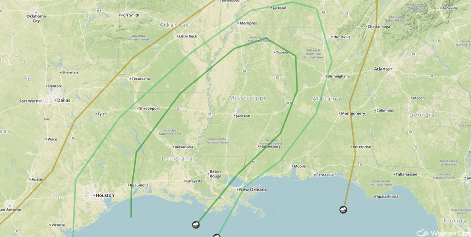
Strong to Severe Thunderstorms Possible Across the Southern US on Saturday
A strong cold front is forecast to move southeastward into southern portions of the U.S. on Saturday, with thunderstorms developing along and ahead of it, especially by the afternoon and early evening time frame. Increasing low-level moisture, as well as favorable wind shear ahead of the front, will allow for the potential for thunderstorm development. Damaging winds will be the primary hazard with the strongest storms, but large hail and damaging winds cannot be ruled out. Thunderstorms should begin to decrease by late evening as they exit region.
Major Cities in Region: Houston, TX, Baton Rouge, LA, Jackson, MS, Memphis, TN, Birmingham, AL
 SPC Convective Outlook for Saturday
A Look Ahead
As the area of low pressure bringing wintry precipitation to portions of the Rockies, Plains, Great Lakes, and Northeast lifts northeastward into the Northeast and eastern Canada, wintry precipitation will transition to rain across much of the Northeast. To the south, showers and thunderstorms will develop ahead of the cold front. As the front moves eastward, precipitation will transition to a mixture of snow, sleet, and freezing rain.
Early next week, a frontal system moving into the Pacific Northwest may allow for heavy snowfall. Accumulations in excess a foot will be possible for the higher elevations. In addition, there will be the potential for excessive rainfall across portions of western Washington.
This is just a brief look at current weather hazards. We can provide you site-specific forecast information for the purpose of protecting your personnel and assets. Try a 7-day demo right away and learn how timely precision weather information can enhance your bottom line.


