


by David Moran, on Aug 30, 2018 10:54:49 AM
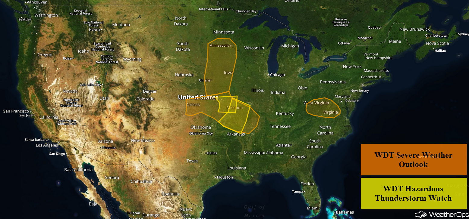
Thunderstorms are forecast across the Missouri Valley, Mississippi Valley, and Kansas on Thursday as an area of low pressure moves through the region. Some of this activity may produce excessive rainfall across the Central Great Plains into the Midwest. A weak area of low pressure will allow for the development of thunderstorms across Virginia.
- Thunderstorms across the Missouri Valley, Mississippi Valley, and Kansas on Thursday
- Excessive Rainfall Thursday from the Central Great Plains into the Midwest
- Potential for Thunderstorms across Virginia on Thursday
- Risk for Thunderstorms Friday for the Central and Northern Plains into the Upper Midwest
- Excessive Rainfall for the Midwest on Friday
- Thunderstorms Saturday from the Mid Mississippi Valley into the Central Plains
- Potential for Excessive Rainfall across the Midwest on Saturday
- Tropical Update
US Hazards
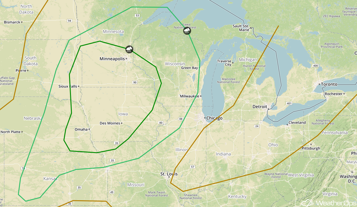
Thunderstorms across the Missouri Valley, Mississippi Valley, and Kansas on Thursday
A cluster of thunderstorms is ongoing across Central and Northeast Kansas, which is expected to move eastward through the day. As instability increases due to daytime heating, these storms will intensify. Severe winds will be the primary hazard, but isolated instances of large hail and tornadoes cannot be ruled out. Additional development is forecast further north later into the evening and overnight hours. Severe winds will be the primary hazard, but there will also be a potential for hail.
Major Cities in Region: North Platte, NE, Pierre, SD, Sioux Falls, SD, Omaha, NE, Kansas City, MO, Des Moines, IA, Minneapolis, MN, St. Louis, MO
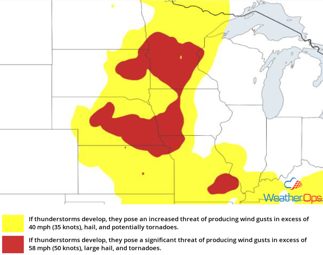
Thunderstorm Risk for Thursday
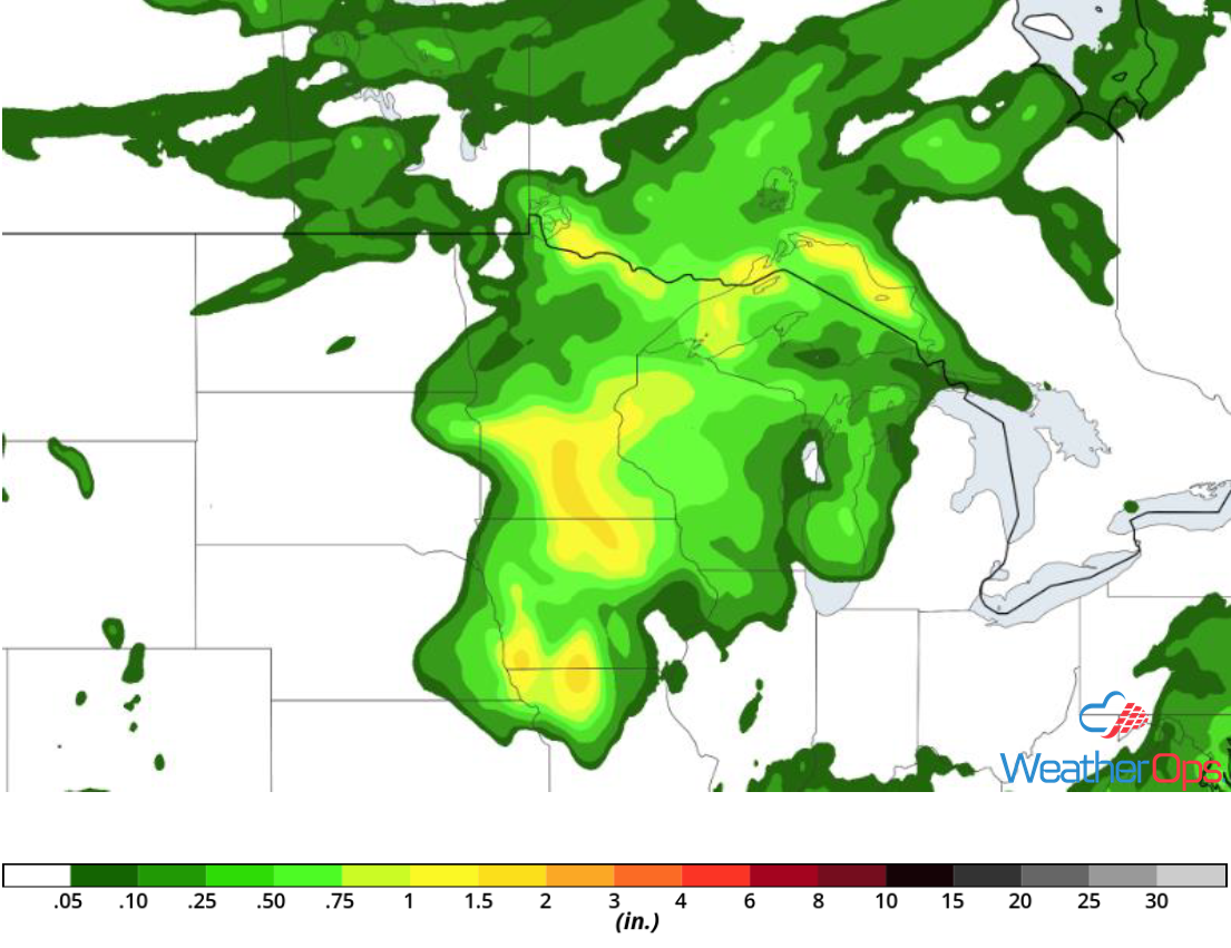
Excessive Rainfall Thursday from the Central Great Plains into the Midwest
Some of the thunderstorm activity described above will have the potential to produce excessive rainfall. Rainfall accumulations of 1-2 inches with locally higher amounts in excess of 3 inches are forecast.
Major Cities in Region: Independence, KS, Joplin, MO
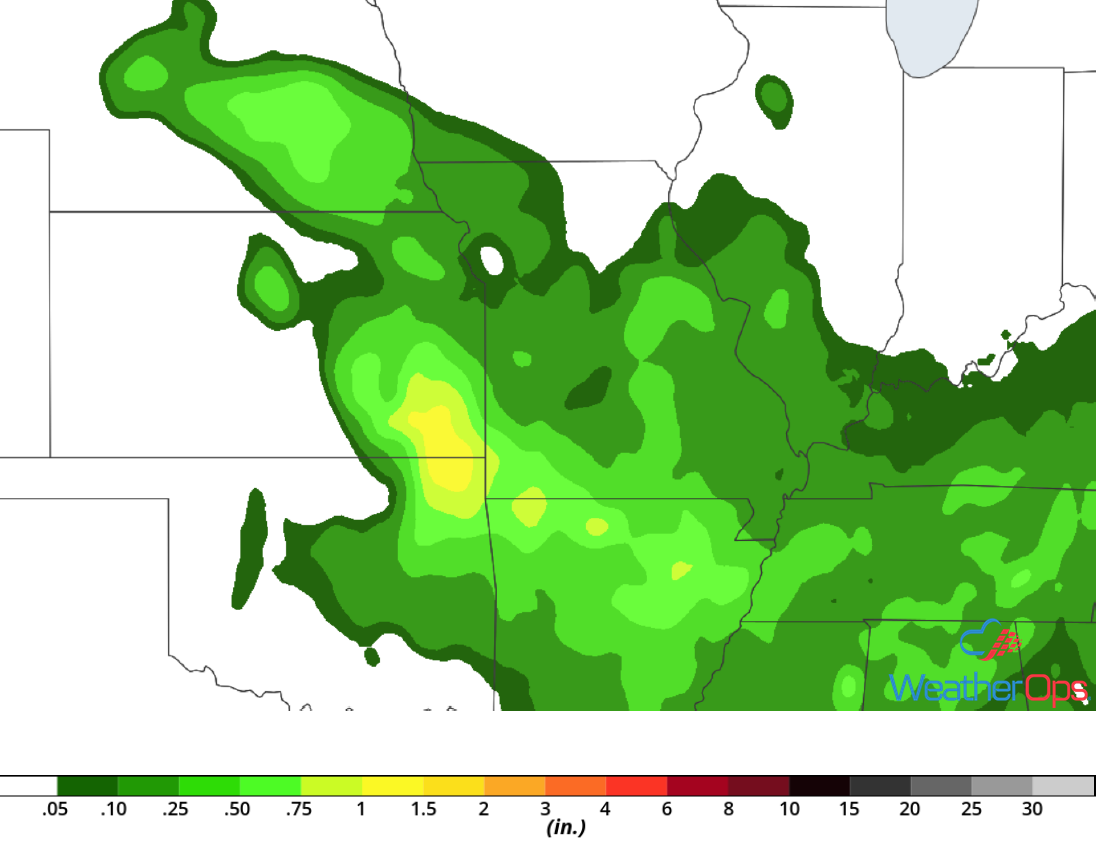
Rainfall Accumulation for Thursday
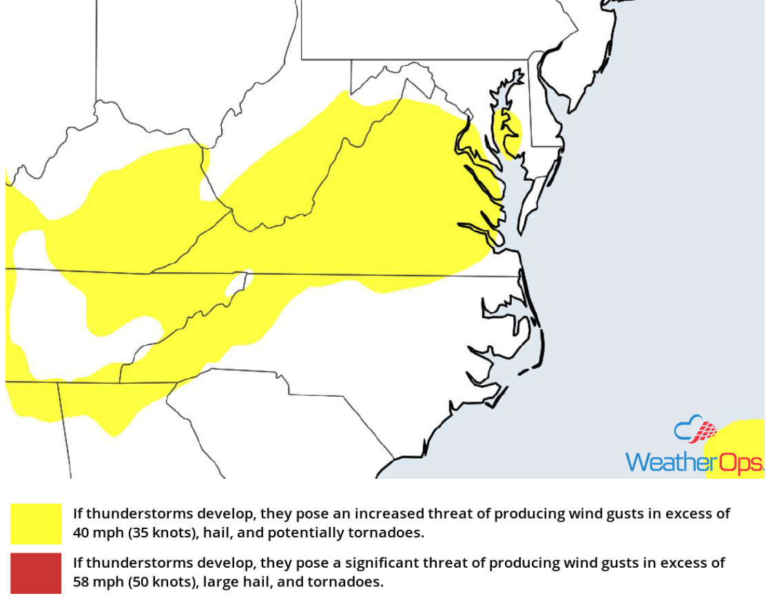
Potential for Thunderstorms across Virginia on Thursday
Daytime heating and moisture will allow instability to build through the afternoon. A weak area of low pressure is forecast to move through the region, allowing for the development of thunderstorms. While widespread impacts are not expected, the stronger storms could produce isolated damaging winds.
Major Cities in Region: Blacksburg, VA, Richmond, VA, Virginia Beach, VA
Thunderstorm Risk for Thursday
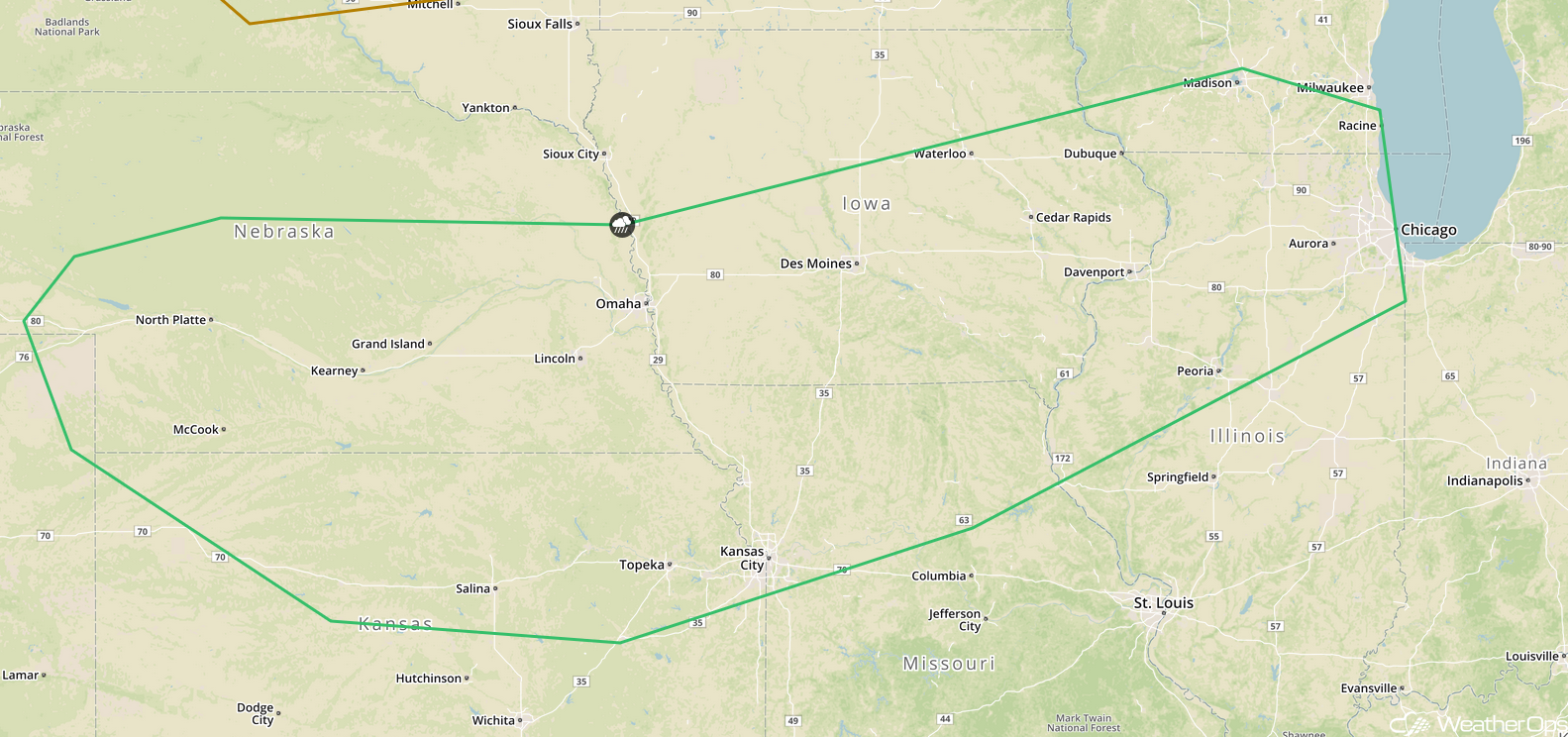
Risk for Thunderstorms Friday for the Central and Northern Plains into the Upper Midwest
A large cluster of thunderstorms is expected to be ongoing during the morning hours. Although these storms are not expected to become severe, stronger cells could produce small hail and gusty winds. These storms are expected to dissipate by late morning. As the afternoon progresses, instability will build. This will allow for the redevelopment of thunderstorms during the late afternoon and early evening. Damaging winds, large hail, and an isolated tornado or two will be potential hazards. As these storms become more linear overnight, the primary hazard will become severe winds.
Major Cities in Region: Dodge City, KS, Sioux Falls, SD, Omaha, NE, Kansas City, MO, Des Moines, IA, Minneapolis, MN, Green Bay, WI
SPC Convective Outlook for Friday
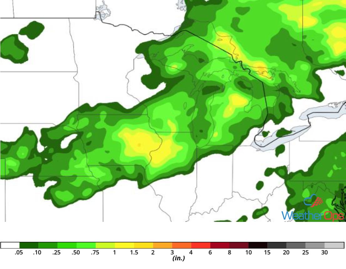
Excessive Rainfall for the Midwest on Friday
In addition to the thunderstorm risk described above, there will also be a potential for excessive rainfall. Rainfall amounts of 1-2 inches with locally higher amounts in excess of 3 inches are expected. Given the recent rainfall, there will be a risk for localized flooding.
Major Cities in Region: Omaha, NE, Minneapolis, MN
Rainfall Accumulation for Friday
Thunderstorms Saturday from the Mid Mississippi Valley into the Central Plains
A cluster of thunderstorms will likely be ongoing Saturday morning. Although this activity is not expected to be severe, stronger cells may produce gusty winds and small hail. These thunderstorms will dissipate later in the morning. Into the afternoon, daytime heating and moisture will allow for the redevelopment of thunderstorms. Severe wind and large hail will be the primary hazards with these storms.
Major Cities in Region: North Platte, NE, Topeka, KS, Omaha, NE, Kansas City, MO, Des Moines, IA, Chicago, IL
SPC Convective Outlook for Saturday
Potential for Excessive Rainfall across the Midwest on Saturday
Thunderstorm activity described above will have the potential to produce heavy to excessive rainfall across the Midwest on Saturday. Rainfall accumulations will range 1-2 inches with locally higher amounts in excess of 3 inches.
Major Cities in Region: Omaha, NE, Des Moines, IA, Cedar Rapids, IA
Rainfall Accumulation for Saturday
Tropical Update
Potential Tropical Cyclone Six is 425 miles east-southeast of the Cabo Verde Islands and is moving westward at 12 mph. This general motion with a turn toward the west-northwest is expected to continue for the next few days. On the forecast track, it is expected to move near or over the southern Cabo Verde Islands on Friday. Maximum sustained winds are near 30 mph with higher gusts. Some strengthening is expected and this disturbance is expected to become a tropical storm over the next day or so.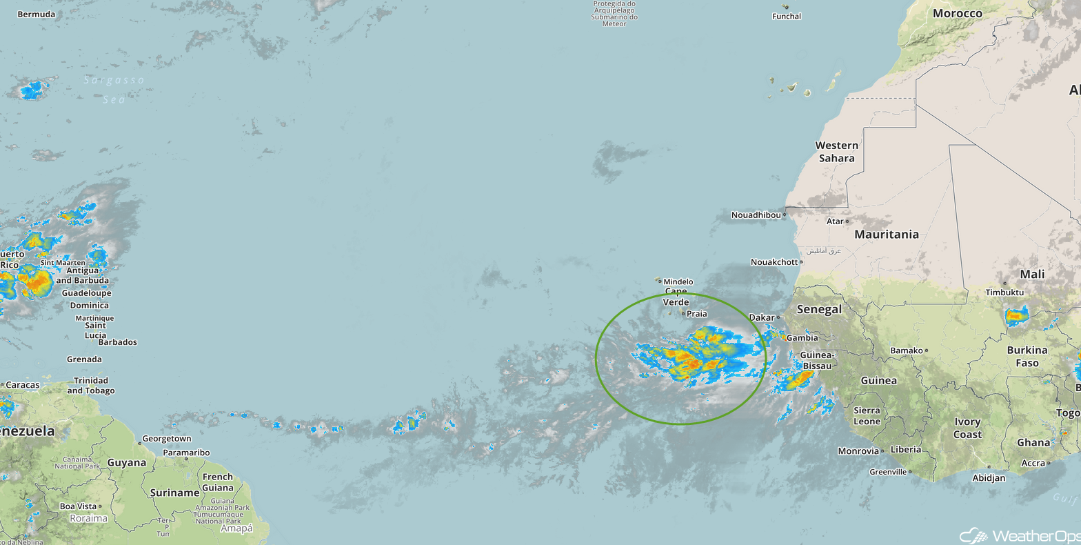
Enhanced Infrared Satellite
A Look Ahead
Thunderstorms may continue from the Northern Plains into the Great Lakes on Sunday along and ahead of a cold front. This activity may continue into Monday; some storms could produce heavy rain. Additional activity is forecast to develop on Tuesday. In addition, showers and thunderstorms may develop across the High Plains. By Wednesday, heavy rain may move into the Upper Midwest and Great Lakes.
