National Weather Summary for Thursday, August 25, 2016
by David Moran, on Aug 25, 2016 12:06:50 PM
A stalled frontal boundary across portions of the Mid Mississippi Valley into western Texas will be the focus for thunderstorm development on Thursday. A few weak disturbances moving across portions of the eastern US and instability will bring the potential for thunderstorms from the Mississippi Valley into the Northeast. The stalled front will begin to lift northward on Friday, allowing for the development of thunderstorms across the Southern Plains. By the weekend, an area of low pressure over the Northern Plains will bring the potential for thunderstorms across portions of the Midwest and Missouri Valley.
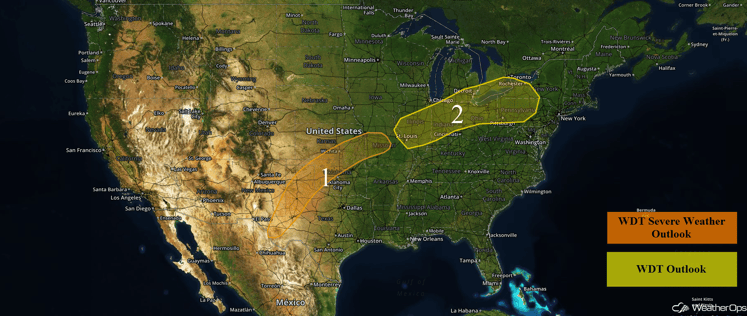
US Hazards
Region 1
There will be a chance for strong to severe thunderstorms across portions of the Mid-Mississippi Valley southward into western Texas on Thursday. Thunderstorms are expected to develop during the afternoon hours along a stalled frontal boundary where the atmosphere is expected to become conducive for severe thunderstorms due to daytime heating. The coverage is forecast to be isolated over Missouri and more scattered to possibly widespread over the Plains states. The primary hazards with any storm that becomes severe will be large hail and damaging winds, with these threats persisting into early evening. Rainfall amounts of 1-3 inches with isolated higher amounts in excess of 4 inches will be possible.
Update: 1:58pm CDT Storms are beginning to develop across Region 1
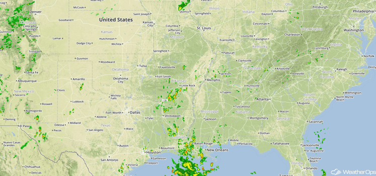
Radar 1:58pm CDT
Major Cities in Region: Odessa, TX, Lubbock, TX, Amarillo, TX, Wichita, KS, Kansas City, MO
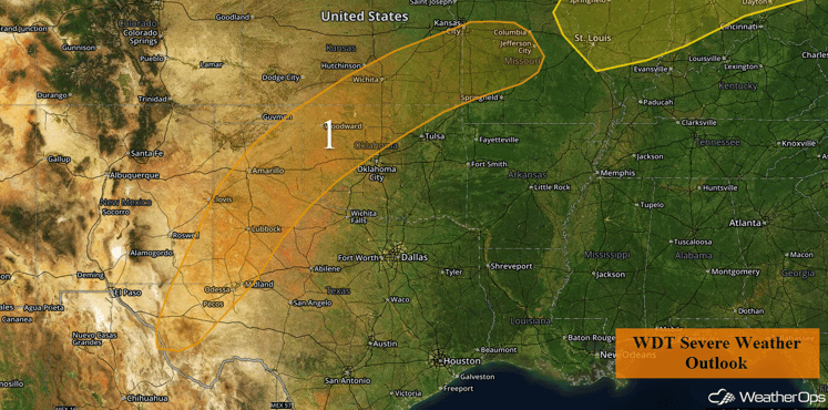
Region 1
Region 2
A series of weak disturbances from a system over the southwestern US will move over Region 2 this afternoon and tonight. With daytime heating and abundant moisture, instability will be sufficient for the development of isolated to widely scattered strong to severe thunderstorms. The primary threat from these storms will be damaging winds, though an isolated tornado cannot be ruled out. Storms could develop as early as midday and will last into the evening and overnight hours.
Major Cities in Region: St. Louis, MO, Detroit, MI, Columbus, OH, Pittsburgh, PA, Buffalo, NY
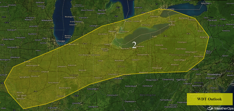
Region 2
Strong to Severe Thunderstorms Possible Friday across the Southern Plains
The stationary front across the Plains will begin to lift northeastward throughout the day on Friday. As this happens, strong to severe thunderstorms will continue to be possible over the region. Just to the east of the Rockies, upslope flow from the easterly winds due to high pressure to the north will provide the opportunity of strong to severe thunderstorm development along the mountain range with thunderstorms progressing to the east. The primary threats with any thunderstorms that form will be large hail and damaging winds. These showers and thunderstorms will also bring the threat for heavy rainfall with amounts of 1-3 inches. Locally higher amounts in excess of 4 inches are possible, especially within heavier areas of thunderstorms.
Major Cities in Region: Dodge City, KS, Wichita, KS, Kansas City, MO
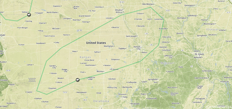
SPC Convective Outlook for Friday
Strong to Severe Thunderstorms Possible across the Midwest and Missouri Valley on Saturday
A developing surface low over the border of Nebraska and South Dakota will bring the threat for strong to severe thunderstorms across portions of the Northern Plains. Ahead of a northeastward moving warm front, marginal instability due to modest daytime heating, combined with ample moisture and marginal wind shear, will allow for the development of thunderstorms along and ahead of a cold font. At this time, the primary threats with any thunderstorms that do form are expected to be damaging winds.
Major Cities in Region: Bismarck, ND, Pierre, SD, Omaha, NE, Kansas City, MO. Des Moines, IA, Milwaukee, WI, Chicago, IL, Dayton, OH
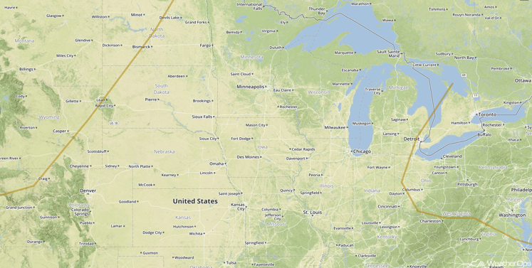
SPC Convective Outlook for Saturday
Tropical Update
Gaston (green oval) has weakened from a hurricane to a tropical storm and is moving toward the northwest at 17 mph. This general motion is expected to continue through Friday. Gaston is expected to turn toward the west-northwest on Saturday and possibly strengthening to a hurricane again.
Further west, Invest 99L is centered just to the southeast of the Turks and Caicos Islands (red oval). The environment is marginally conducive for further development over the next day or so, but conditions are expected to become more favorable over the weekend. Heavy rain is possible over Puerto Rico today. Heavy rainfall and strong winds are possible for portions of Hispaniola, the Turks and Caicos, and the Bahamas over the next few days.
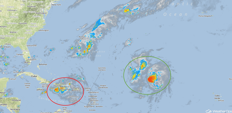
Tropical Satellite
A Look Ahead
As Invest 99L gets closer to the east coast of Florida, there remains the potential for heavy to excessive rainfall across portions of Florida from this tropical system. Given current model variability, overall confidence remains low on the exact track of the system as well as the exact location of the excessive rainfall. Should Invest 99L develop a surface circulation and track along a similar track as to what is currently forecast, heavy to excessive rainfall from the tropical system is expected. Interests within Florida should continue to monitor the development and track of Invest 99L throughout the week.
This is just a brief look at current weather hazards. We can provide you site-specific forecast information for the purpose of protecting your personnel and assets. Try a 7-day demo right away and learn how timely precision weather information can enhance your bottom line.


