


by David Moran, on Aug 2, 2018 11:30:44 AM
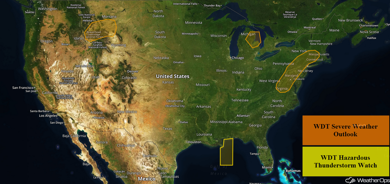
Thunderstorms will continue across the central Gulf of Mexico through early Thursday afternoon as a disturbance moves across the region. An upper level trough will provide forcing for the development of thunderstorms across the Mid Atlantic and Northeast Thursday and Friday. Excessive rainfall is expected from the Southeast into the Northeast through Friday as multiple rounds of showers and thunderstorms develop. Thunderstorms may develop across portions of Michigan ahead of a cold front. Across the Northern Rockies, thunderstorms will develop as an area of low pressure moves eastward.
- Thunderstorms Continuing across the Central Gulf of Mexico through Thursday Afternoon
- Potential for Thunderstorms through Friday for the Mid Atlantic and Northeast
- Excessive Rainfall from the Southeast into the Northeast through Friday
- Thunderstorms Thursday for Portions of Michigan
- Risk for Thunderstorms for the Northern Rockies Thursday
- Thunderstorm Potential Friday for the Central Plains
US Hazards
Thunderstorms Continuing across the Central Gulf of Mexico through Thursday Afternoon
Scattered showers and thunderstorms are continuing across the central Gulf of Mexico this morning. Although wind shear is weak, strong instability remains in place over the region. A disturbance moving over the region will provide lift, allowing for the development widespread showers and thunderstorms across the region. Some of the stronger storms could produce winds in excess of 35 knots, frequent lightning, heavy rain, and waterspouts.
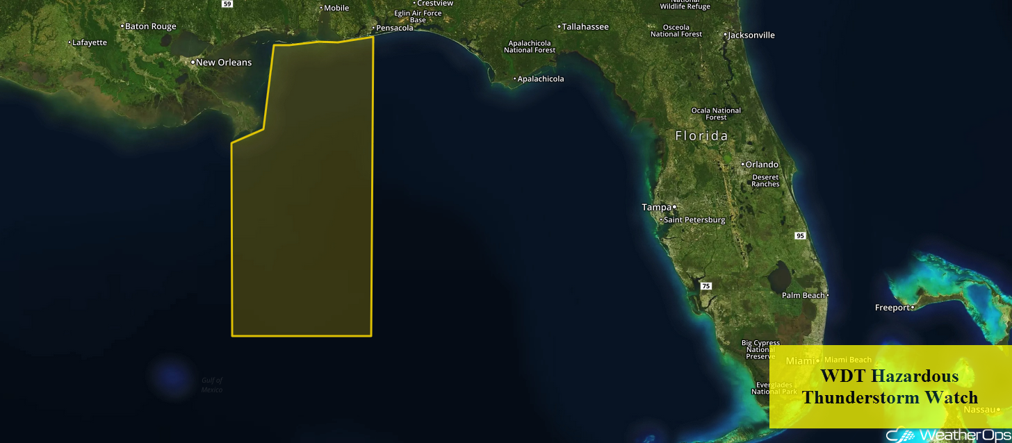
WDT Hazardous Thunderstorm Watch
Potential for Thunderstorms through Friday for the Mid Atlantic and Northeast
An upper level trough over the Mississippi River Valley will move little today and tomorrow. At the surface, southerly flow along the East Coast will bring ample moisture northward across the region over the next two days. This low level moisture, combined with daytime heating during the afternoon, will allow instability to build across the region. With this instability, strong wind shear, and forcing from the trough, scattered showers and thunderstorms are forecast today and tomorrow from portions of the Mid Atlantic into the Northeast. A few isolated to widely scattered thunderstorms could become strong to severe. Damaging winds and small hail will be the primary hazards with the stronger storms.
Major Cities in Region: Richmond, VA, Washington, DC, Baltimore, MD, Philadelphia, PA, New York, NY, Albany, NY, Bridgeport, CT
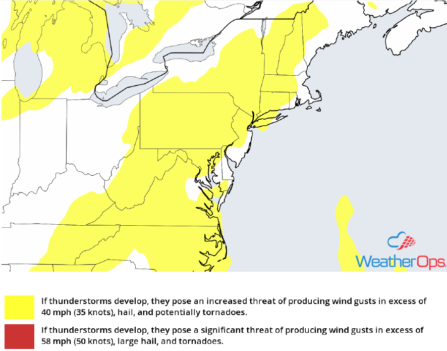
Thunderstorm Risk for Thursday and Friday
Excessive Rainfall from the Southeast into the Northeast through Friday
In addition to the thunderstorm potential described above, there will be a potential for excessive rainfall. Two day rainfall amounts of 1-3 inches with locally higher amounts in excess of 4 inches are forecast across the region. Given the heavy rainfall from previous days, widespread flooding and excessive runoff is likely over the next two days.
Major Cities in Region: Tallahassee, FL, Asheville, NC, Blacksburg, VA, Washington, DC, Baltimore, MD, Scranton, PA
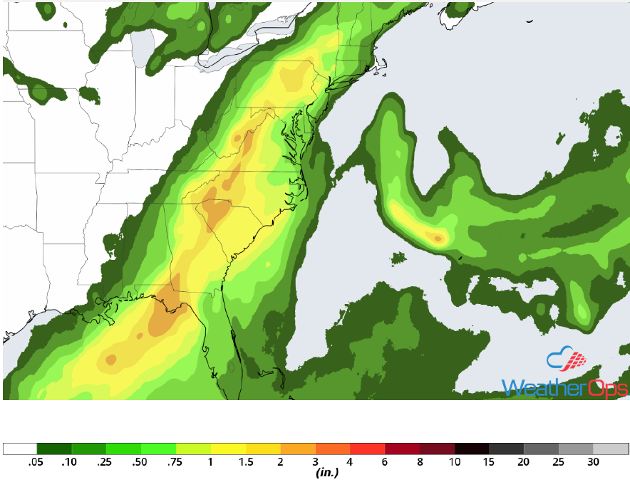
Rainfall Accumulation through Friday
Thunderstorms Thursday for Portions of Michigan
A slow moving cold front will be the focus for the development of thunderstorms today. Damaging winds will be the primary hazard with the stronger storms.
Major Cities in Region: Bay City, MI
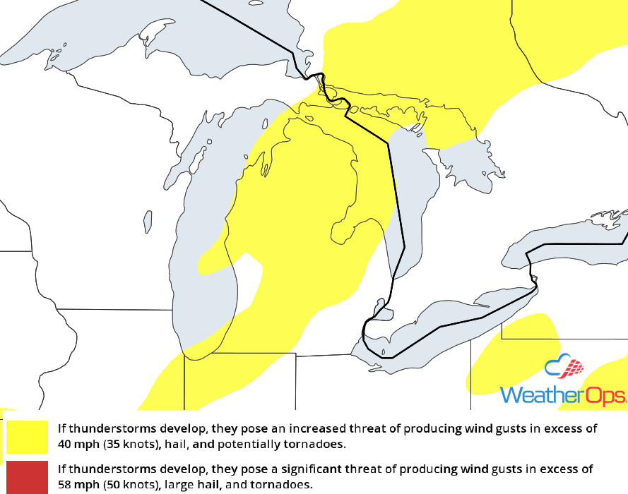
Thunderstorm Risk for Thursday
Risk for Thunderstorms for the Northern Rockies Thursday
An area of low pressure will move around the northern edge of a ridge centered across the Desert Southwest. Although instability and moisture will be marginal, strong wind shear and forcing will be sufficient for the development of isolated to widely scattered showers and thunderstorms across the region. A few of these storms will become strong to severe with damaging winds and large hail the primary hazards with the stronger storms. Activity will quickly diminish after sunset.
Major Cities in Region: Butte, MT, Billings, MT
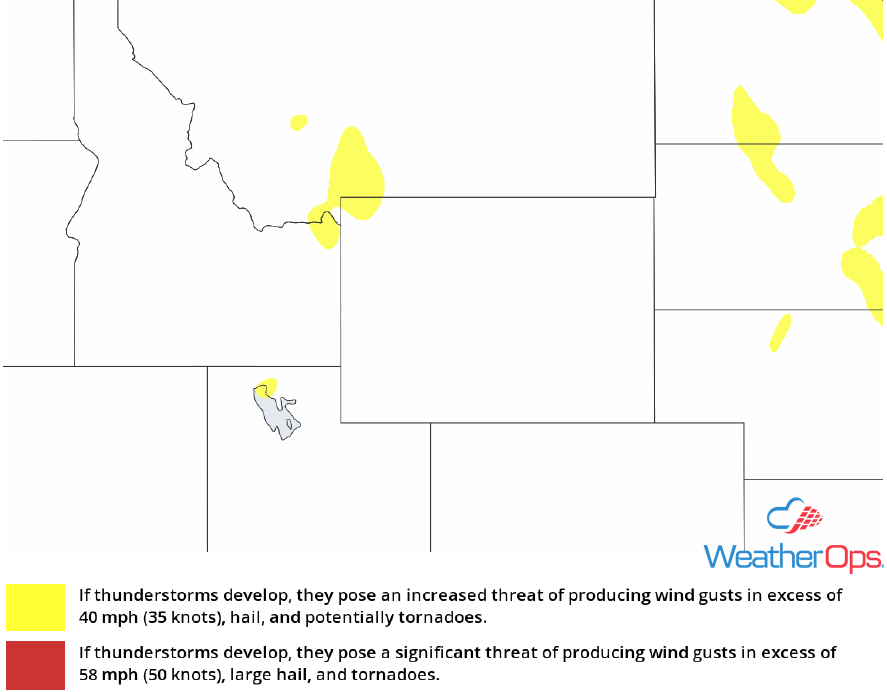
Thunderstorm Risk for Thursday
Thunderstorm Potential Friday for the Central Plains
A trough is forecast to track eastward from the Pacific Northwest into the Northern Plains on Friday. At the surface, an area of low pressure and its associated fronts will also track slowly across the region. To the south of the low, instability will build across much of the region during the late afternoon. This will allow for the development of showers and thunderstorms ahead of the associated cold front. Additional thunderstorm activity is likely during the overnight hours as the low level jet increases across the region. Some of these storms will be strong to severe with damaging winds, large hail, and an isolated tornado or two potential hazards with the stronger storms.
Major Cities in Region: North Platte, NE, Pierre, SD, Fargo, ND, Grand Forks, ND, Sioux Falls, SD, International Falls, MN, Duluth, MN
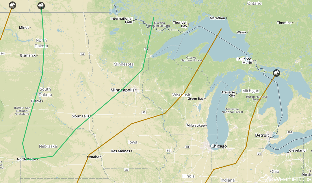
SPC Convective Outlook for Friday
A Look Ahead
A cold front will be the focus for the development of showers and thunderstorms on Saturday across the Upper Midwest and Central Plains. On Sunday, a few light showers may move into portions of the Great Lakes. Showers and thunderstorms may develop across portions of the Plains on Monday ahead of a cold front. This activity will spread into the Great Lakes on Tuesday. By Wednesday, showers and thunderstorms will extend from the Northeast into the Ohio River Valley.
