National Weather Summary for Thursday, August 10, 2017
by David Moran, on Aug 10, 2017 10:52:10 AM
Upslope flow will allow for the development of thunderstorms across portions of the Central Plains and Front Range on Thursday. Thunderstorms may develop across portions of the Midwest on Thursday as a warm front moves northward.
- Thunderstorms for the Central Plains and Front Range on Thursday
- Risk for Thunderstorms Thursday across the Midwest
- Thunderstorm Potential for the Central High Plains on Friday
- Thunderstorms Friday from the Lower to Mid Mississippi Valley
- Excessive Rainfall for the Southern Plains on Friday
- Potential for Thunderstorms Saturday for the Central High Plains
- Risk for Excessive Rainfall across the Southern Plains continues into Saturday
- Tropical Update
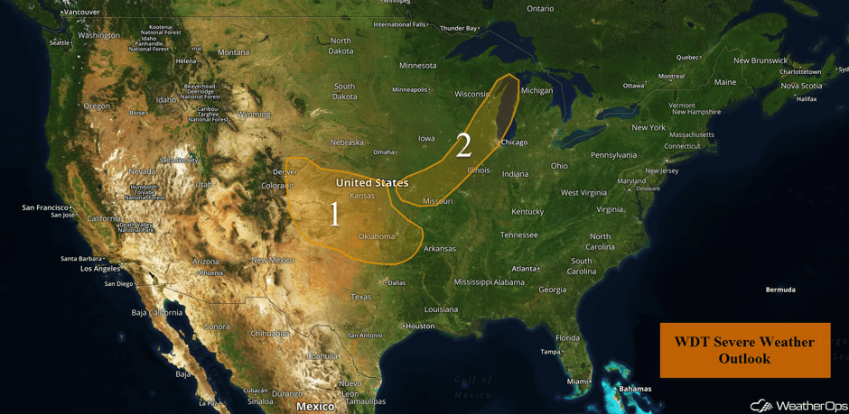 US Hazards
Thunderstorms for the Central Plains and Front Range on Thursday
Strong to severe thunderstorms are expected to develop today in the High Plains. An area of low pressure should develop near the Oklahoma Panhandle. Upslope flow north of the low into eastern Colorado, along with instability as a result of daytime heatingm should be sufficient for the development of thunderstorms this afternoon. A cold front moving into the region from the north should stall and will be the focus for further storm development. Storms are expected to cluster and then move to the southeast across western and central Kansas. These storms will move into northern and eastern Oklahoma during the late afternoon, evening, and overnight hours. Damaging winds, frequent lightning, and heavy rainfall will be the primary hazards, but a few isolated tornadoes cannot be ruled out.
Update 12:00pm CDT: Severe thunderstorm capable of hail and damaging winds northwest of Liberal, KS.
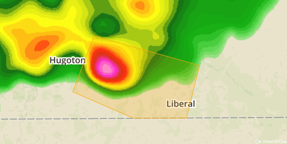 Radar 12pm CDT
Update 12:16pm CDT: Severe thunderstorm capable of large hail and damaging winds northwest of Colby, KS.
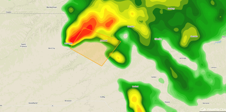 Radar 12:16pm CDT
Update 1:06pm CDT: Thunderstorm producing hail near 2" in diameter in the Oklahoma Panhandle.
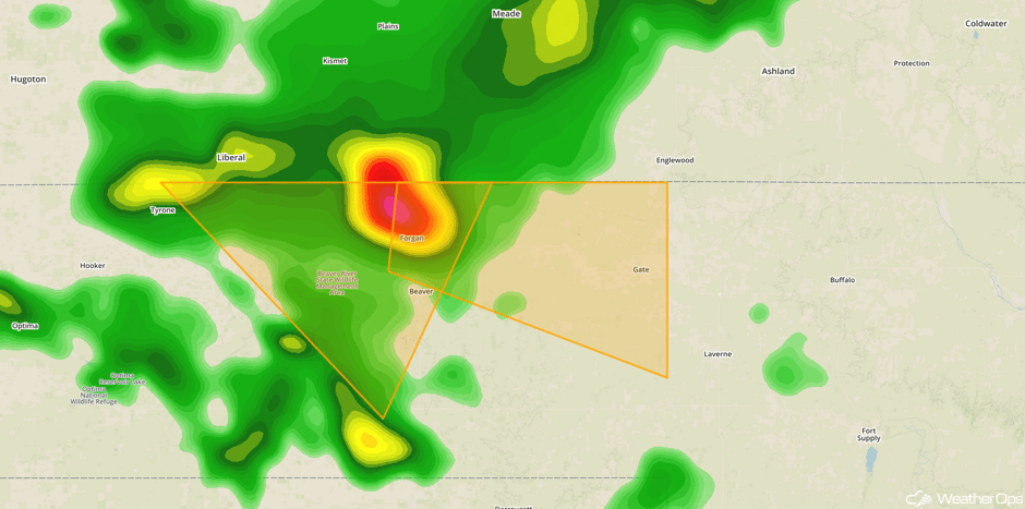 Radar 1:06pm CDT
Major Cities in Region: Denver, CO, Amarillo, TX, Wichita, KS, Oklahoma City, OK, Tulsa, OK
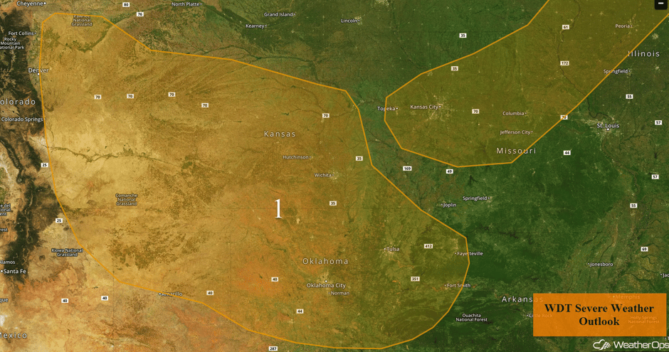 Region 1
Risk for Thunderstorms Thursday across the Midwest
Isolated strong to severe thunderstorms are expected today along and ahead of a front that will extend from an area of low pressure to another area of low pressure in the High Plains. In the upper levels, a wave will be moving over the Northern Plains and into the Upper Mississippi Valley. At the surface, an associated area of low pressure will move into Minnesota and Wisconsin. Its cold front will move southward into the threat region during the afternoon and evening. The air mass ahead of the front should destabilize enough for the development of thunderstorms during the afternoon into the evening, Large hail and damaging winds will be the primary hazards, but an isolated tornado or two cannot be ruled out.
Major Cities in Region: Kansas City, MO, Madison, WI, Green Bay, WI, Milwaukee, WI, Chicago, IL
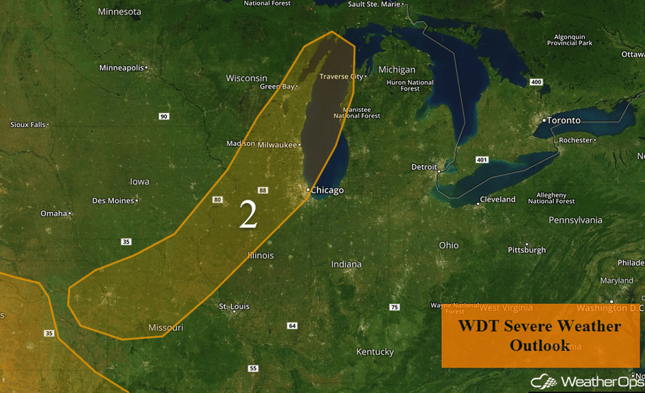 Region 2
Thunderstorm Potential for the Central High Plains on Friday
Upslope flow across the Central High Plains will provide the lift for strong to severe thunderstorms on Friday. With sufficient moisture and daytime heating, instability will develop, leading to thunderstorm development in the afternoon and evening. Strong winds and hail, along with frequent lightning and heavy rain, will be the primary threats with any storms that develop.
Major Cities in Region: Denver, CO, Colorado Springs, CO, Cheyenne, WY
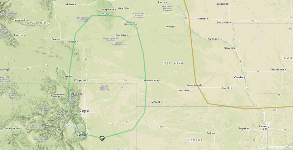 SPC Convective Outlook for Friday
Thunderstorms Friday from the Lower to Mid Mississippi Valley
As the cold front progresses to the southeast into portions of the Lower and Mid Mississippi River Valley, strong to severe thunderstorms are forecast into the afternoon. An upper level trough along with a cold front will provide support for thunderstorm development as instability builds. Strong winds, hail, frequent lightning, and heavy rainfall will be the primary hazards with any storms that develop.
Major Cities in Region: Little Rock, AR, Memphis, TN
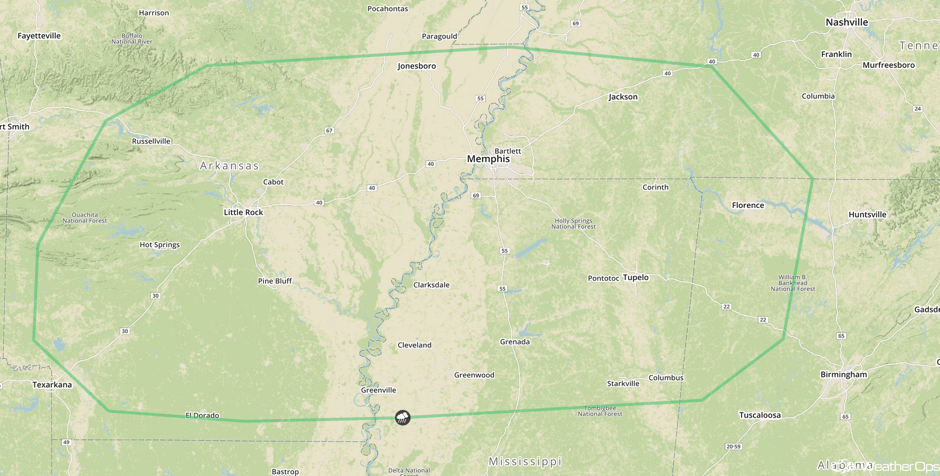 SPC Convective Outlook for Friday
Excessive Rainfall for the Southern Plains on Friday
Scattered showers are expected to develop across the Southern Plains on Friday along a stationary front. Due to rainfall from previous days, any additional rainfall will lead to the potential for flooding and flash flooding. As the front remains stationary, rainfall amounts between 1.5-2 inches with locally higher amounts in excess of 3 inches expected.
Major Cities in Region: Guymon, OK, Oklahoma City, OK, Tulsa, OK, Fort Smith, AR
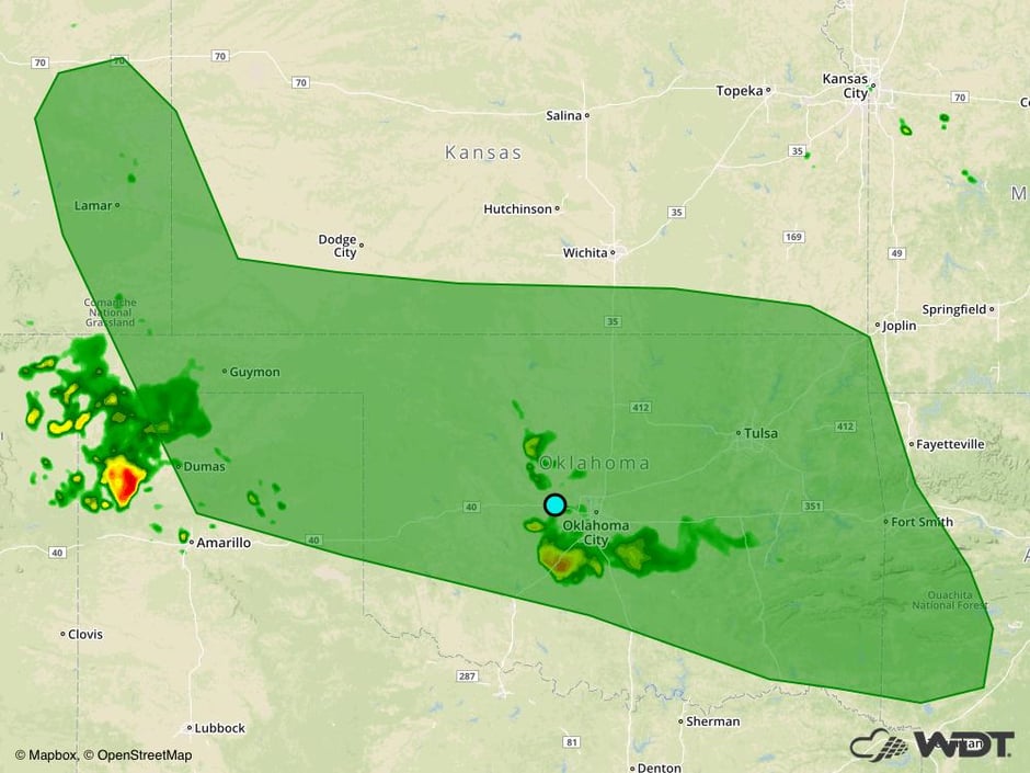 Excessive Rainfall Risk Outline for Friday
Potential for Thunderstorms Saturday for the Central High Plains
There is a potential for scattered strong to severe thunderstorms across the Central High Plains on Saturday. An upper level trough is forecast to move to the southeast across the region with sufficient moisture and daytime heating at the surface. As a result, thunderstorms may develop during the mid to late afternoon. Strong winds and large hail will be the primary hazards, as well as frequent lightning and heavy rain.
Major Cities in Region: Rapid City, SD, North Platte, NE
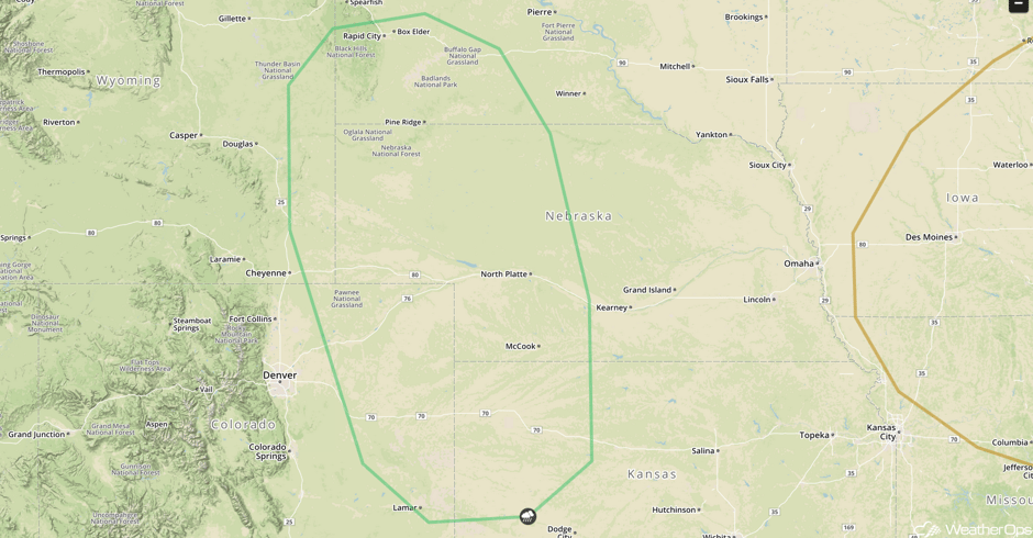 SPC Convective Outlook for Saturday
Risk for Excessive Rainfall across the Southern Plains continues into Saturday
The stationary front across portions of the Southern Plains is forecast to remain in place on Saturday resulting in the potential for heavy to excessive rainfall to the region. The primary location for the heaviest rain is located in eastern Oklahoma, although heavy rainfall could occur in any location across the area. Total additional rainfall is forecast between 1.0-2.5 inches with locally heavier amounts in excess of 3.5 inches. Flash flooding and flooding will be a possibility due to additional rainfall.
Major Cities in Region: Oklahoma City, OK, Sherman, TX, Tulsa, OK, Fort Smith, AR
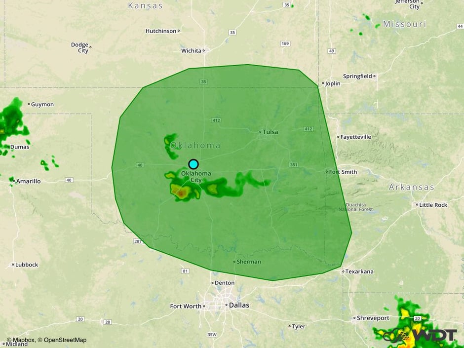 Excessive Rainfall Risk Outline for Saturday
Tropical Update
Tropical Storm Franklin (green oval) has dissipated over Mexico with winds near 30 mph. Additional weakening is expected over the next day or so. Rainfall amounts of 4-8 inches with isolated higher amounts in excess of 15 inches are forecast for portions of Mexico, resulting in flash flooding and mudslides.
A trough of low pressure over the Bahamas (red oval) is producing disorganized showers and thunderstorms. Although further development is not anticipated, this system could bring locally heavy rainfall to Florida and the Bahamas.
Showers and thunderstorms associated with an area of low pressure (blue oval) a couple hundred miles east-northeast of the northern Leeward Islands have changed little overnight. Some slow development may occur during the weekend while the system continues to move northwestward.
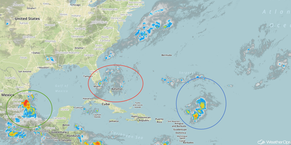 Enhanced Infrared Tropical Satellite
A Look Ahead
A stalled front will remain across the Southern Plains through Monday, allowing for the potential for excessive rainfall. Three day rainfall totals of 3-6 with locally higher amounts in excess of 8 inches will be possible. In addition, flooding and flash flooding will be a concern.
This is just a brief look at current weather hazards. We can provide you site-specific weather forecast information for the purpose of protecting your personnel and assets and to assess your weather risk. Try a 7-day demo right away and learn how timely precision weather information can enhance your bottom line.


