


by David Moran, on Apr 5, 2018 11:14:19 AM
Snow will continue for the Northern Rockies, as well as the Northern and Central Plains, through Friday evening as an area of low pressure moves through the region. Excessive rainfall is expected for portions of northern California Thursday through Saturday.
- Snow from the Northern Rockies into the Central Plains through Friday Evening
- Excessive Rainfall through Saturday for Northern California
- Thunderstorms for the Southern Plains and Lower Mississippi Valley Friday into Saturday
- Potential for Excessive Rainfall Friday Evening into Saturday across the Lower Mississippi Valley
- Freezing Rain and Snow Friday Afternoon into Saturday from the Midwest into the Ohio Valley
- Snow for the Mid Atlantic on Saturday
- Thunderstorms Saturday across the Southeast
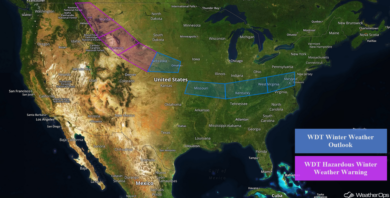 US Hazards

Snow from the Northern Rockies into the Central Plains through Friday Evening
Snow is expected to continue from the Northern High Plains into the Central Plains through Friday afternoon as an area of low pressure moves across the region. Snow across the Northern Rockies will increase in intensity and spread southward Thursday evening into Friday. Snow will mostly be moderate but some heavy snow is possible at times. Travel disruptions are likely.
- Northern and Central Montana: Accumulations of 4-6 inches with locally higher amounts in excess of 8 inches are expected in the lower elevations. In the higher elevations, 6-10 inches with locally higher amounts in excess of a foot are forecast.
- Southern Montana and Northern Wyoming: 3-6 inches with locally higher amounts in excess of 8 inches are forecast for the lower elevations. In the higher elevations. 6-10 inches with locally higher amounts in excess of a foot are expected.
- Southeastern Wyoming into Western Nebraska: Accumulations will range 4-8 inches with locally higher amounts in excess of 10 inches. For the higher elevations, 6-10 inches with locally higher amounts in excess of a foot are expected.
- Central and Eastern Nebraska: 2-4 inches with locally higher amounts in excess of 5 inches are forecast.
Major Cities in Region: Helena, MT, Great Falls, MT, Billings, MT, Sheridan, WY, North Platte, NE, Lincoln, NE
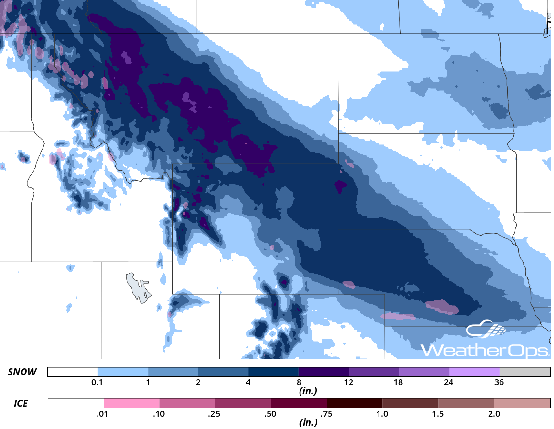 Snow Accumulation through Friday
Excessive Rainfall through Saturday for Northern California
There will be the potential for excessive rainfall across portions of northern California through Saturday as moisture streams into the region. Rainfall amounts of 2-4 inches are expected for much of the region. Higher elevations may pick up in excess of 6 inches, allowing for a risk for flooding and mudslides. In addition, melting snow may add to the flooding and mudslide risk.
Major Cities in Region: Eureka, CA, San Francisco, CA, Sacramento, CA
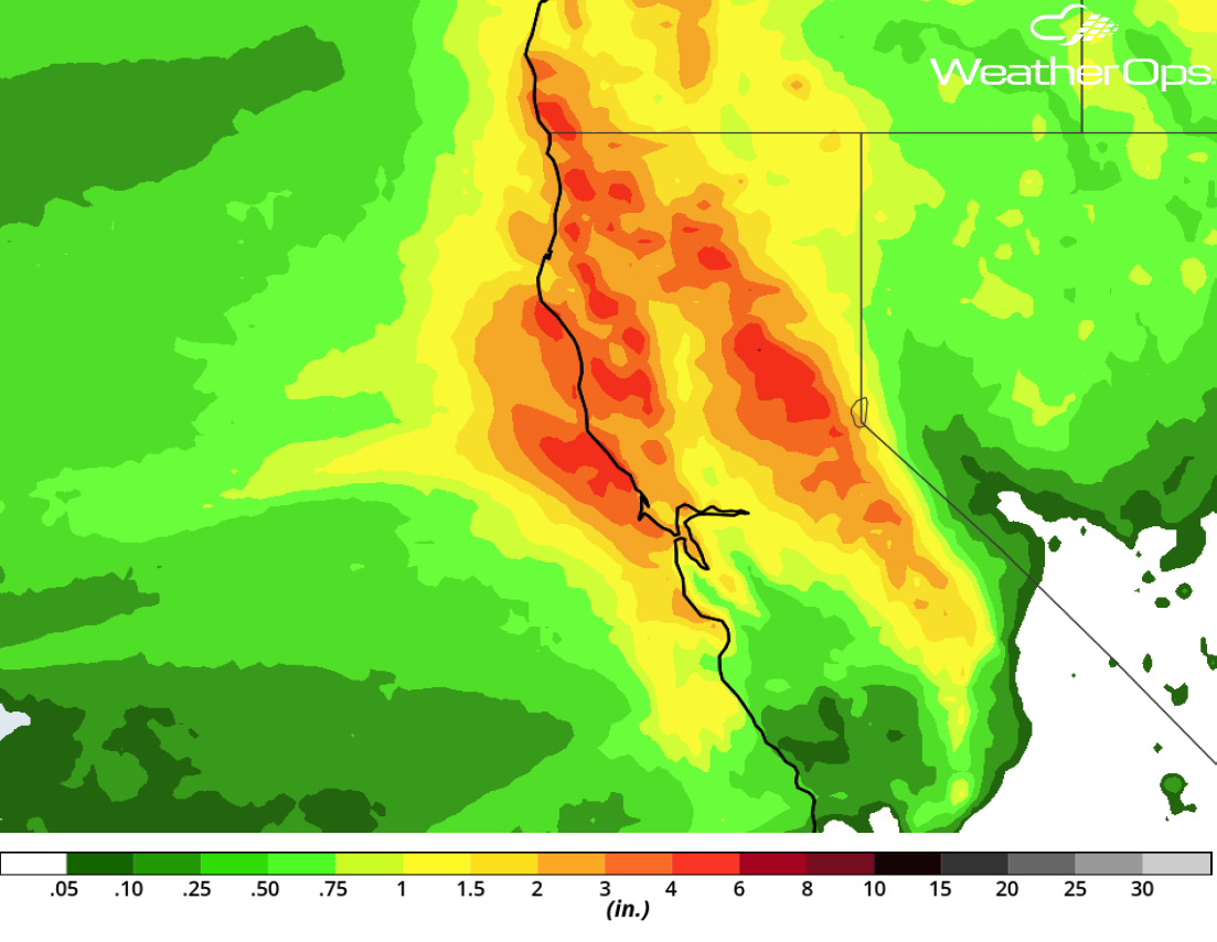 Rainfall Accumulation through Saturday
Thunderstorms for the Southern Plains and Lower Mississippi Valley Friday into Saturday
Strong to severe thunderstorms may develop across the Southern Plains into the Lower Mississippi Valley on Friday as an area of low pressure intensifies. Elevated thunderstorms will develop along a warm front extending from Oklahoma into the Arklatex region with an accompanying hail threat. Scattered thunderstorms are expected to develop across East Texas into Louisiana as a cold front begins to push southward. Large hail, damaging winds, and tornadoes will all be potential hazards with any thunderstorm that becomes severe. Storms will increase in coverage along the front during the evening and overnight hours. Large hail and damaging winds will be the primary hazards as the storms move into the Mississippi Valley.
Major Cities in Region: Austin, TX, Dallas, TX, Houston, TX, Shreveport, LA, Little Rock, AR, Baton Rouge, LA, Jackson, MS
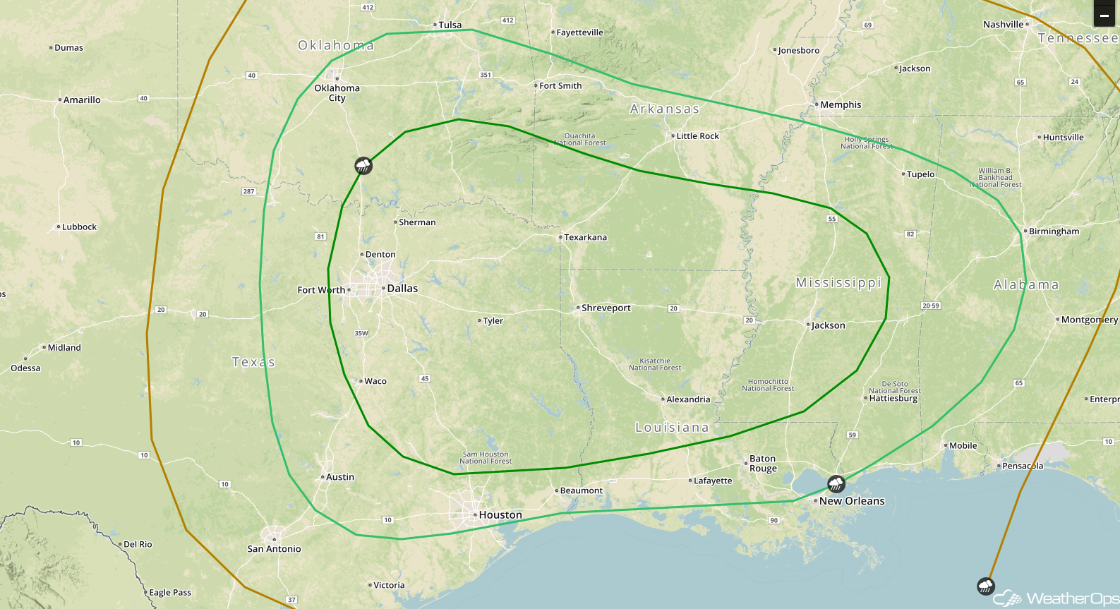 SPC Convective Outlook for Friday
Potential for Excessive Rainfall Friday Evening into Saturday across the Lower Mississippi Valley
In addition to the severe weather potential across the Lower Mississippi Valley, there will be the potential for excessive rainfall. Accumulations of 1-3 inches with locally higher amounts in excess of 4 inches are forecast, resulting in a potential for flash flooding.
Major Cities in Region: Shreveport, LA, Monroe, LA, Jackson, MS
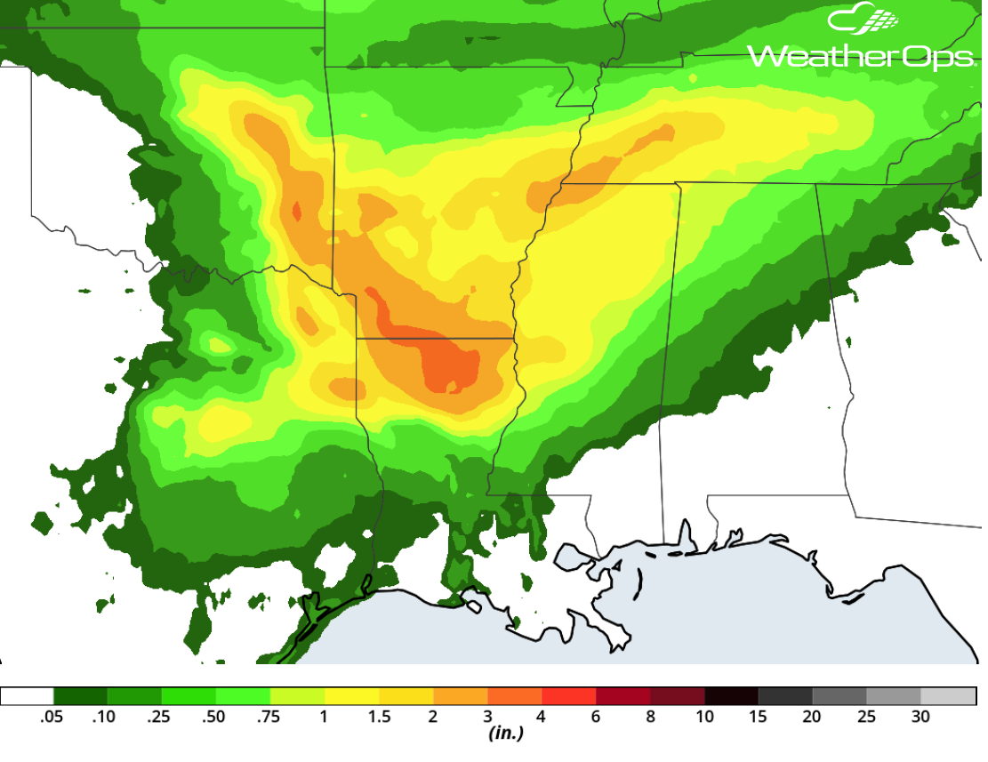 Rainfall Accumulation for Friday and Saturday
Freezing Rain and Snow Friday Afternoon into Saturday from the Midwest into the Ohio Valley
Freezing rain and snow is forecast for portions of the Midwest into the Ohio Valley as an area of low pressure tracks eastward. Precipitation will begin Friday afternoon and evening as a wintry mix before transitioning to snow. Periods of moderate snow can be expected across the region before snow tapers off Saturday afternoon. Snow accumulations of 3-6 inches are forecast in addition to freezing rain accumulations up to 0.10 inch. Gusty winds will lead to blowing snow, making travel difficult and hazardous.
Major Cities in Region: Kansas City, MO, St. Louis, MO, Evansville, IN, Louisville, KY, Cincinnati, OH
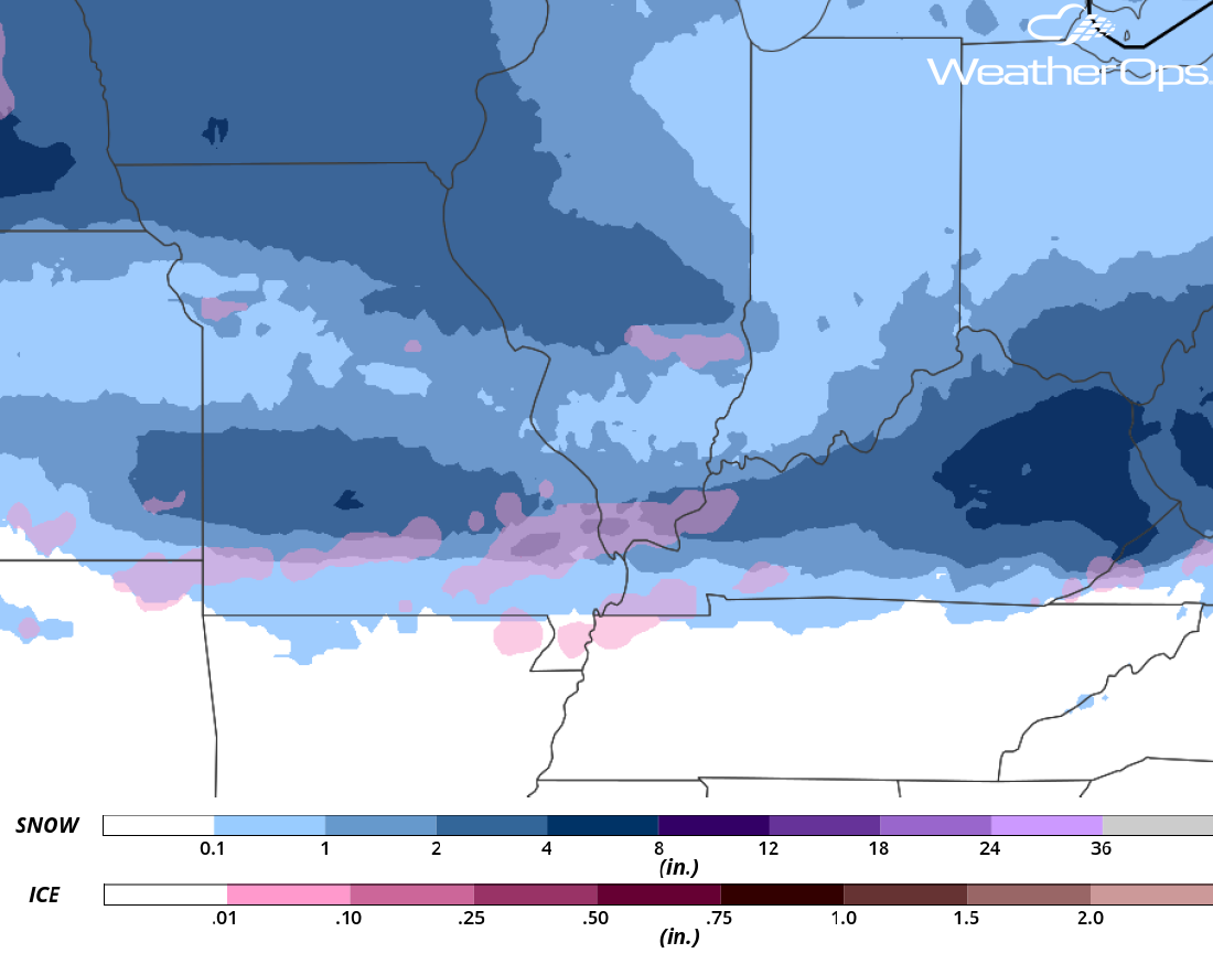 Snowfall Accumulation for Friday and Saturday
Snow for the Mid Atlantic on Saturday
As the area of low pressure described above continues to move eastward, snow is expected for the Mid Atlantic on Saturday. While there is some uncertainty in regard to timing and how far south the cold air will come, snowfall accumulations of 3-6 inches with locally higher amounts in excess of 8 inches are currently forecast.
Major Cities in Region: Clarksburg, WV, Washington, DC, Baltimore, MD
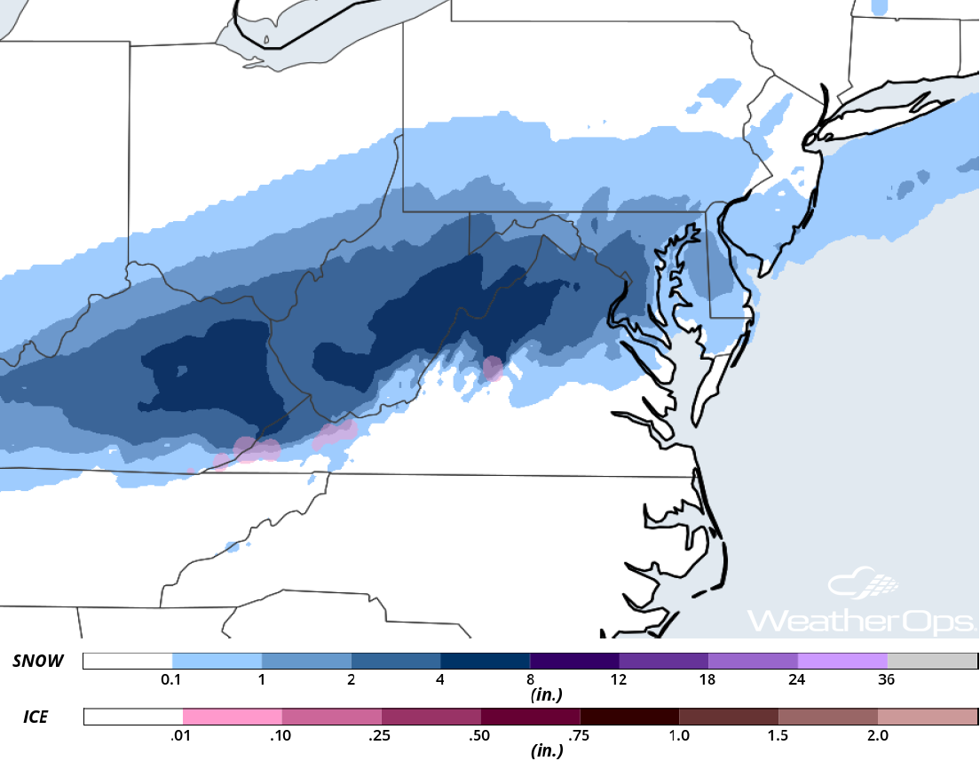 Snow Accumulation for Saturday
Thunderstorms Saturday across the Southeast
Strong to severe thunderstorms are forecast for much of the Southeast on Saturday as a cold front makes its way through the region. Ongoing thunderstorms during the morning hours may produce damaging winds. Additional thunderstorms may develop during the afternoon with damaging winds the primary hazard with any storms that become severe.
Major Cities in Region: New Orleans, LA, Tallahassee, FL, Savannah, GA, Charleston, SC, Myrtle Beach, SC, Wilmington, NC
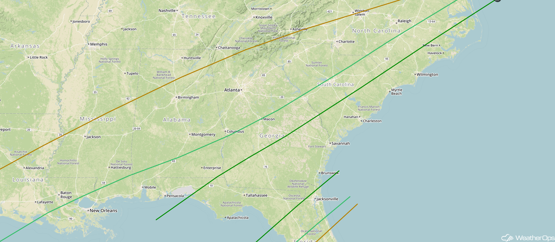 SPC Convective Outlook for Saturday
A Look Ahead
An area of low pressure expected to develop over the Northern Plains will bring snow to portions of the region Sunday and Monday as it moves eastward. While amounts are uncertain, there will be the potential for several inches of snow.
This is just a brief look at current weather hazards. We can provide you site-specific weather forecast information for the purpose of protecting your personnel and assets and to assess your weather risk. Try a 7-day demo right away and learn how timely precision weather information can enhance your bottom line.
