


by David Moran, on Apr 12, 2018 10:57:24 AM
Snow has begun across the Northern Rockies and will continue to move eastward across the Northern Plains, Upper Midwest, Great Lakes, and Northeast through the weekend. There is a risk for severe thunderstorms Friday from the Missouri Valley southward into east Texas and the Lower Mississippi Valley.
- Snow for the Northern Rockies into the Upper Midwest through Friday
- Thunderstorms Friday from the Missouri Valley to East Texas and the Lower Mississippi Valley
- Excessive Rainfall for the Mid to Lower Mississippi Valley on Friday
- Potential for Snow Saturday and Sunday from the Northern Plains into the Northeast
- Thunderstorms from the Upper Midwest to the Gulf Coast on Saturday
- Excessive Rainfall Saturday from the Tennessee Valley to the Gulf Coast
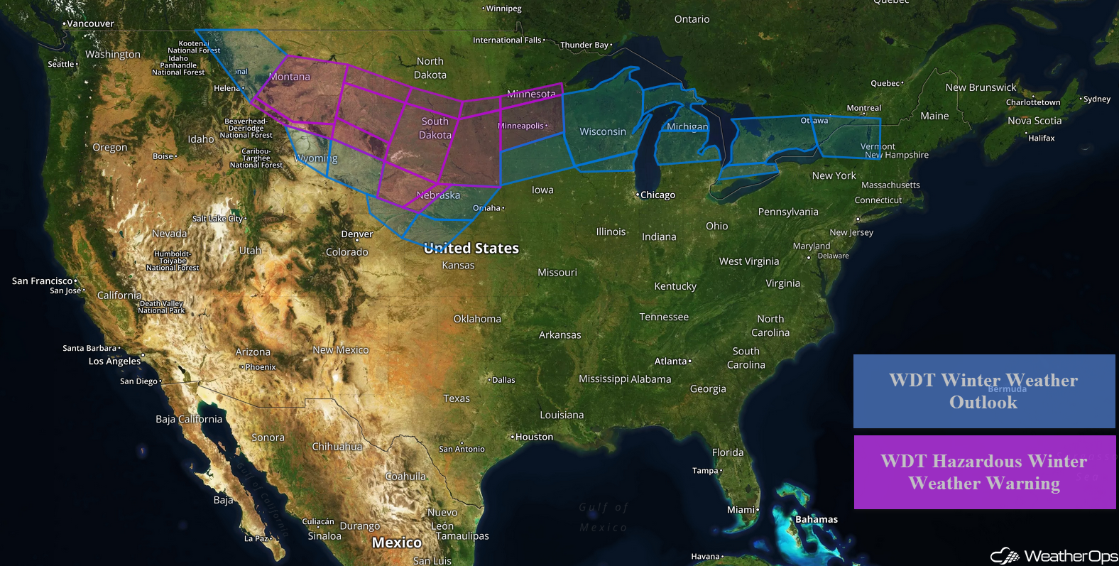 US Hazards

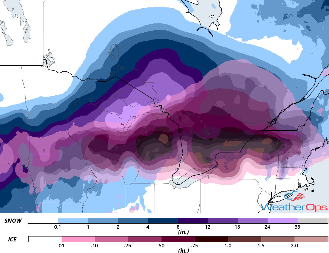
Snow for the Northern Rockies into the Upper Midwest through Friday
Snow will continue to spread from the Northern Rockies into the Upper Midwest through Friday as an area of low pressure moves eastward. Heavy snow and gusty winds may result in blizzard conditions across much of the Dakotas and northern Nebraska on Friday. Freezing rain and snow will spread into portions of Minnesota on Friday. Snow accumulations of 6-12 inches with locally higher amounts in excess of 15 inches are forecast. In addition, ice accumulations up to a quarter inch are forecast from Nebraska into the Great Lakes.
Major Cities in Region: Rapid City, SD, North Platte, NE, Pierre, SD, Sioux Falls, SD, Minneapolis, MN, Green Bay, WI, Milwaukee, WI
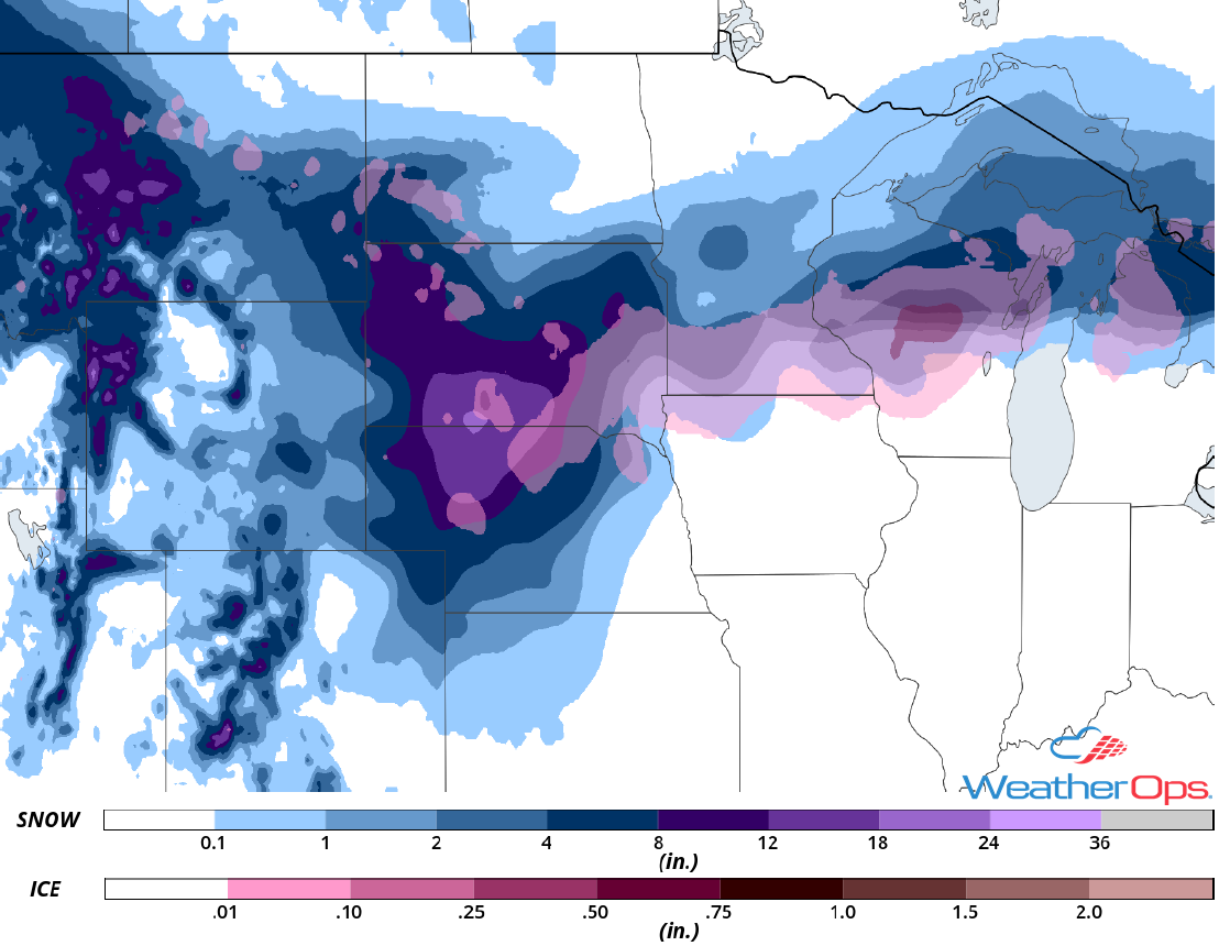 Snow Accumulation through Friday
Thunderstorms Friday from the Missouri Valley to East Texas and the Lower Mississippi Valley
A cold front associated with an area of low pressure over the Northern Plains will extend southward into central Texas on Friday. Ahead of the front, Gulf moisture will surge northward all the way into southern Iowa. Strengthening upper level winds will allow for the development of thunderstorms Friday afternoon into Friday evening. Heavy rain, lightning, damaging winds, and tornadoes will all be potential hazards. The storm threat may increase Friday evening into Friday night from Arkansas southward as low level winds intensify. An enhanced threat of damaging winds and isolated tornadoes will exist across the lower Mississippi Valley.
Major Cities in Region: Tyler, TX, Kansas City, MO, Shreveport, LA, Little Rock, AR, Memphis, TN
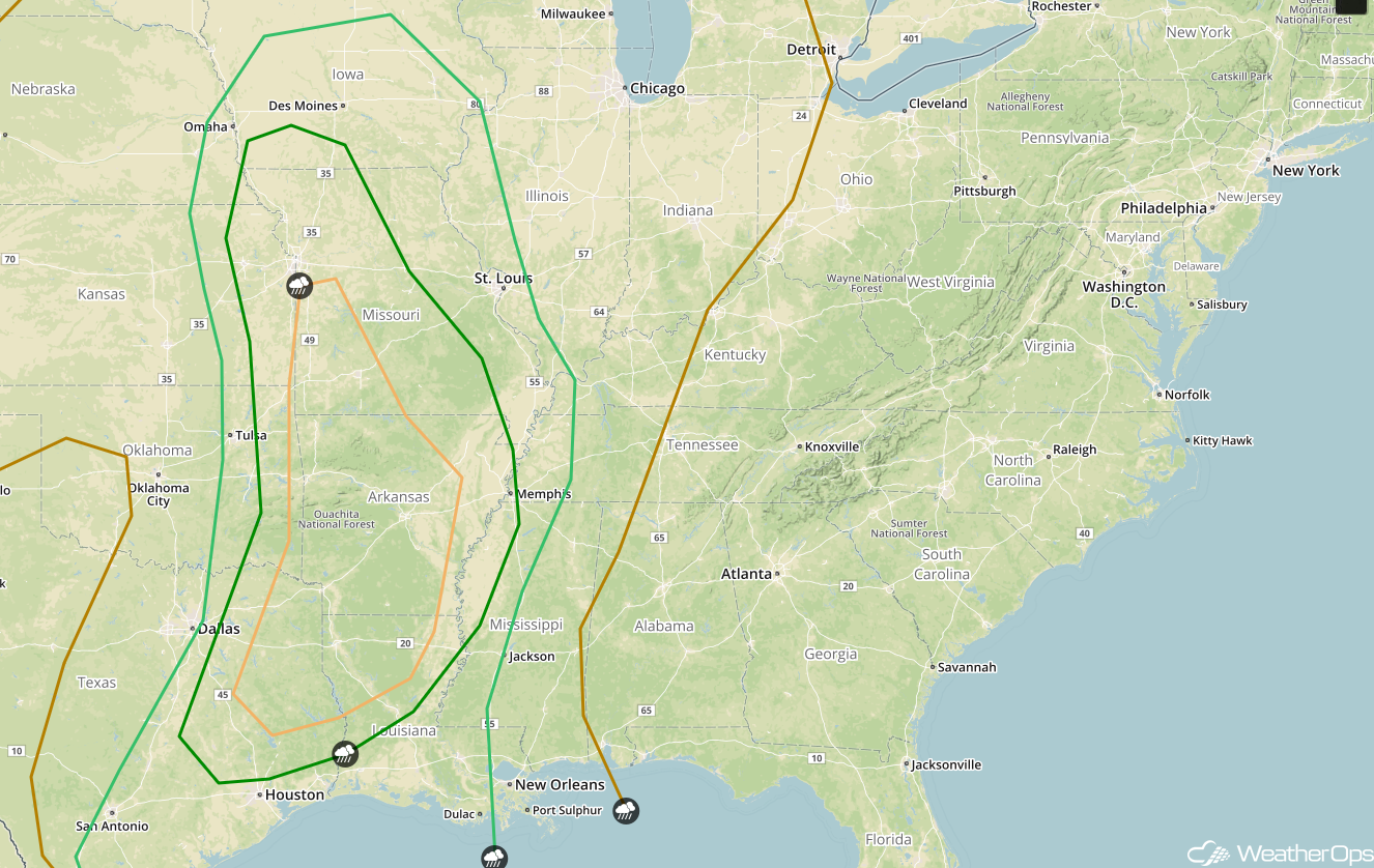 SPC Convective Outlook for Friday
Excessive Rainfall for the Mid to Lower Mississippi Valley on Friday
In addition to the severe thunderstorm potential described above, there will be a risk for excessive rainfall across the Mid and Lower Mississippi Valley on Friday. Rainfall amounts of 2-3 inches with locally higher amounts in excess of 5 inches are forecast, leading to the potential for flash flooding.
Major Cities in Region: Shreveport, LA, Monroe, LA, Little Rock, AR
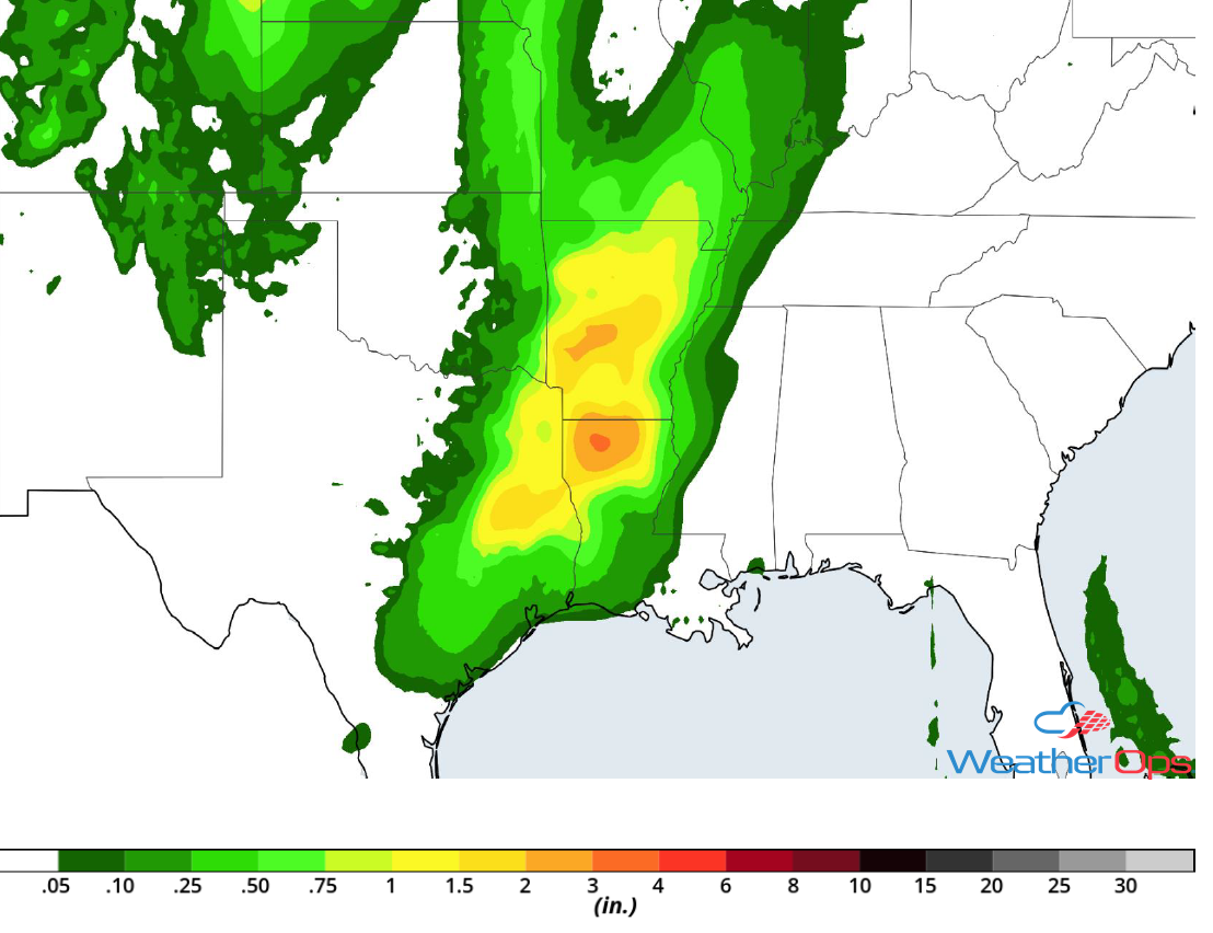 Rainfall Accumulation for Friday
Potential for Snow Saturday and Sunday from the Northern Plains into the Northeast
A strong area of low pressure is forecast to be centered over central Iowa Saturday morning. A warm front will extend eastward into southern Michigan. North of the low and associated front, moderate to heavy snow is forecast from northeast Nebraska, across southern Minnesota, and the Great Lakes. As the low slows down, heavy snow may persist across portions of the Great Lakes on Sunday. Additionally, significant amounts of freezing rain and ice are forecast near and just north of the warm front from southeast Minnesota to Upstate New York Saturday and Sunday. Ice accumulations will range 0.25-0.40 inch with locally higher amounts in excess of 0.50 inch.
Major Cities in Region: Minneapolis, MN, Milwaukee, WI, Green Bay, WI, Traverse City, MI, Watertown, NY
 Snow Accumulation for Saturday and Sunday
Thunderstorms from the Upper Midwest to the Gulf Coast on Saturday
As a cold front continues to advance eastward across the Upper Midwest and Southeast on Saturday there will be a risk for thunderstorms. Thunderstorms ongoing Saturday morning will have the potential to produce large hail, damaging winds, and tornadoes. With daytime heating, the atmosphere may destabilize further, allowing storms to reintensify as they move eastward. Damaging winds and tornadoes will be the primary hazards from north central Alabama southward to the Gulf Coast during the afternoon and evening. Further east, there will be a marginal risk for strong storms overnight.
Major Cities in Region: Jackson, MS, New Orleans, LA, Birmingham, LA, Nashville, TN, Atlanta, GA, Knoxville, TN
 SPC Convective Outlook for Saturday
Excessive Rainfall Saturday from the Tennessee Valley to the Gulf Coast
In addition to the thunderstorms described above, there will be a risk for excessive rainfall. Widespread rainfall amounts of 1-3 inches are forecast with locally higher amounts in excess of 4 inches, leading to a risk for flash flooding.
Major Cities in Region: Jackson, MS, New Orleans, LA, Nashville, TN, Louisville, KY
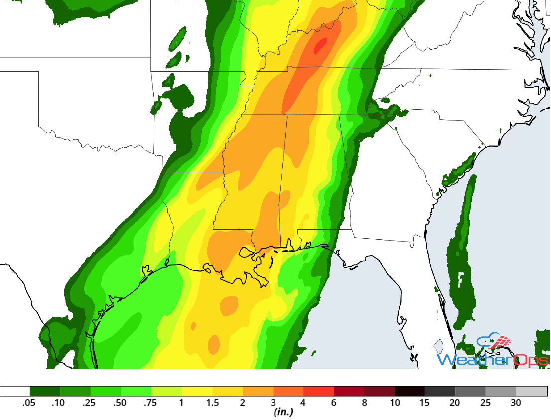 Rainfall Accumulation for Saturday
A Look Ahead
Showers and thunderstorms will continue from portions of the Northeast into the Southeast on Monday as the area of low pressure described above continues to move eastward. Light snow may continue across portions of the Northeast into Tuesday.
This is just a brief look at current weather hazards. We can provide you site-specific weather forecast information for the purpose of protecting your personnel and assets and to assess your weather risk. Try a 7-day demo right away and learn how timely precision weather information can enhance your bottom line.
