by David Moran, on Sep 10, 2018 11:25:56 AM
Thunderstorms will continue across the Northeast on Monday ahead of a cold front. Some activity may have the potential to produce excessive rainfall across the Northeast and Mid Atlantic. Widespread showers and thunderstorms will lead to a risk for excessive rainfall along the Texas coast.
- Thunderstorms across the Northeast on Monday
- Excessive Rainfall Monday for the Northeast and Mid Atlantic
- Risk for Excessive Rainfall along the Texas Coast on Monday
- Potential for Thunderstorms Tuesday across New England
- Thunderstorms for the Northern Plains on Tuesday
- Continued Thunderstorms Wednesday across the Northern Plains
- Tropical Update
US Hazards
Thunderstorms across the Northeast on Monday
A large complex of showers is moving across much of the Northeast this morning. Later this afternoon, instability should be sufficient for the development of a few strong thunderstorms. Damaging winds will be the primary hazard with these storms, but an isolated tornado cannot be ruled out.
Major Cities in Region: State College, PA, Albany, NY, New York, NY
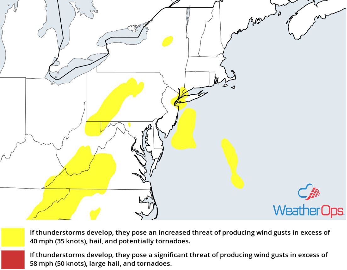
Thunderstorm Risk for Monday
Excessive Rainfall Monday for the Northeast and Mid Atlantic
In addition to the thunderstorms described above, there will be a potential for excessive rainfall. Rainfall amounts will range 1-2 inches with locally higher amounts in excess of 3 inches. This may lead to areas of flooding.
Major Cities in Region: State College, PA, Syracuse, NY, Albany, NY, Salisbury, MD
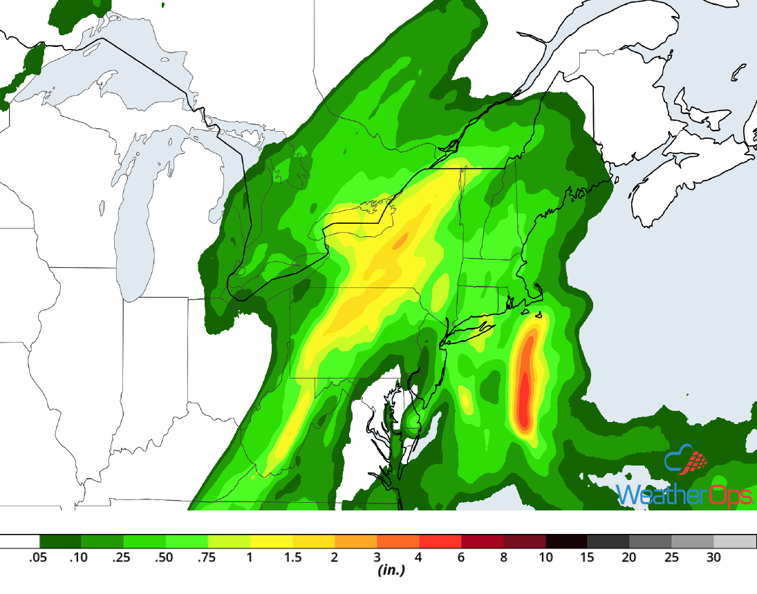
Rainfall Accumulation for Monday
Risk for Excessive Rainfall along the Texas Coast on Monday
Heavy rain will continue on Monday as moisture streams into the region. Rainfall amounts will range 1-3 inches with locally higher amounts, allowing for a risk of flash flooding.
Major Cities in Region: Corpus Christi, TX, Houston, TX
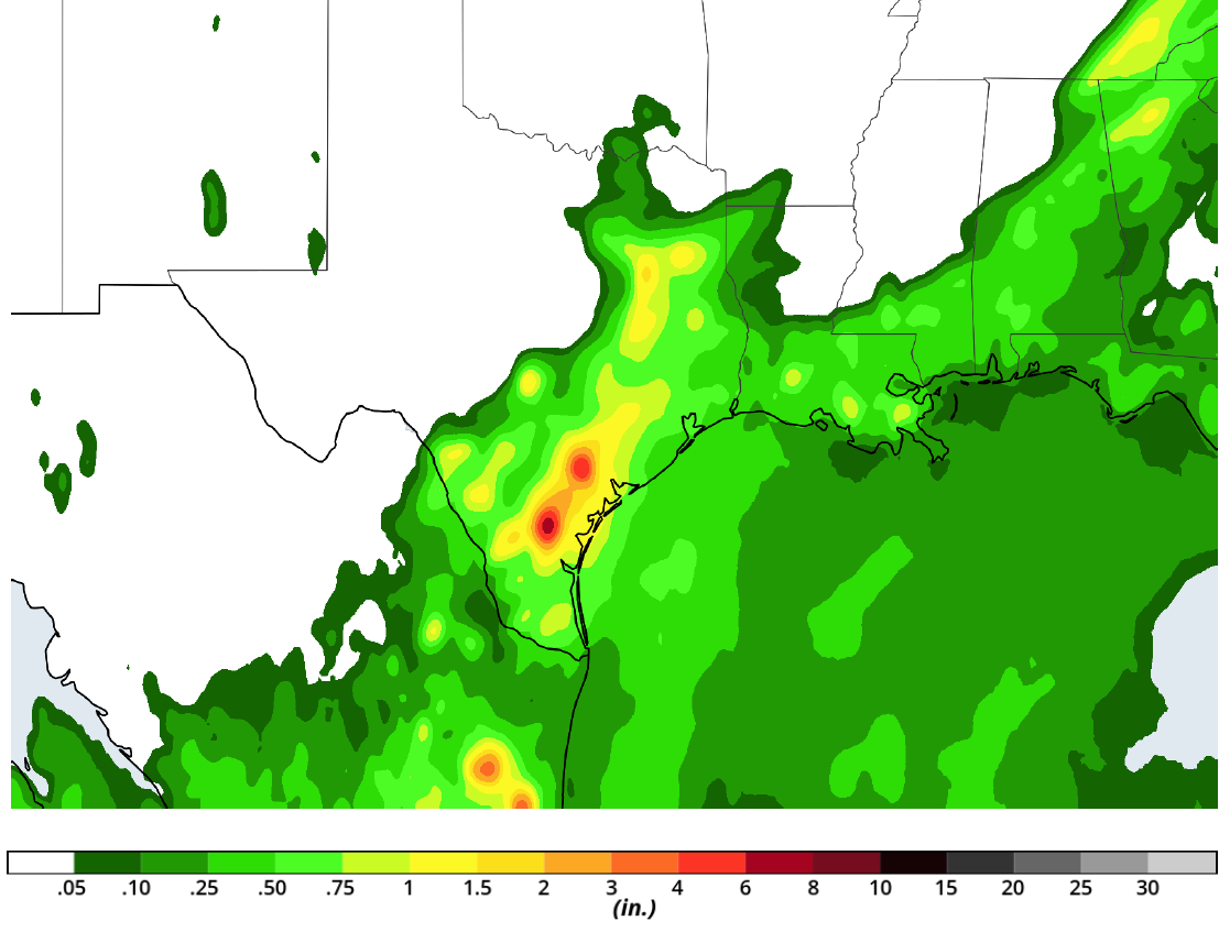
Rainfall Accumulation for Monday
Potential for Thunderstorms Tuesday across New England
A slow moving cold front will move across New England on Tuesday, serving as a focus for the development of thunderstorms. As thunderstorms develop, damaging winds and isolated tornadoes will be the primary hazards with the stronger storms.
Major Cities in Region: Boston, MA, Portland, ME
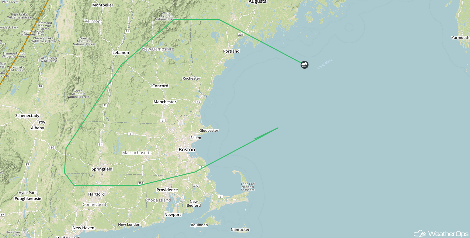
SPC Convective Outlook for Tuesday
Thunderstorms for the Northern Plains on Tuesday
A front is forecast to move into the Northern Plains on Tuesday afternoon. Isolated strong thunderstorms may develop along the front as instability builds due to daytime heating. Damaging winds and hail will be the primary hazards with these storms.
Major Cities in Region: Grand Forks, ND, Fargo, ND
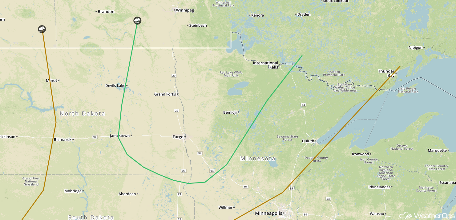
SPC Convective Outlook for Tuesday
Continued Thunderstorms Wednesday across the Northern Plains
Another upper level trough will move along a frontal boundary on Wednesday. As instability builds due to daytime heating, thunderstorms will develop. There will be low end risks for hail, damaging winds, and tornadoes with the stronger storms that develop.
Major Cities in Region: Minot, ND, Grand Forks, ND
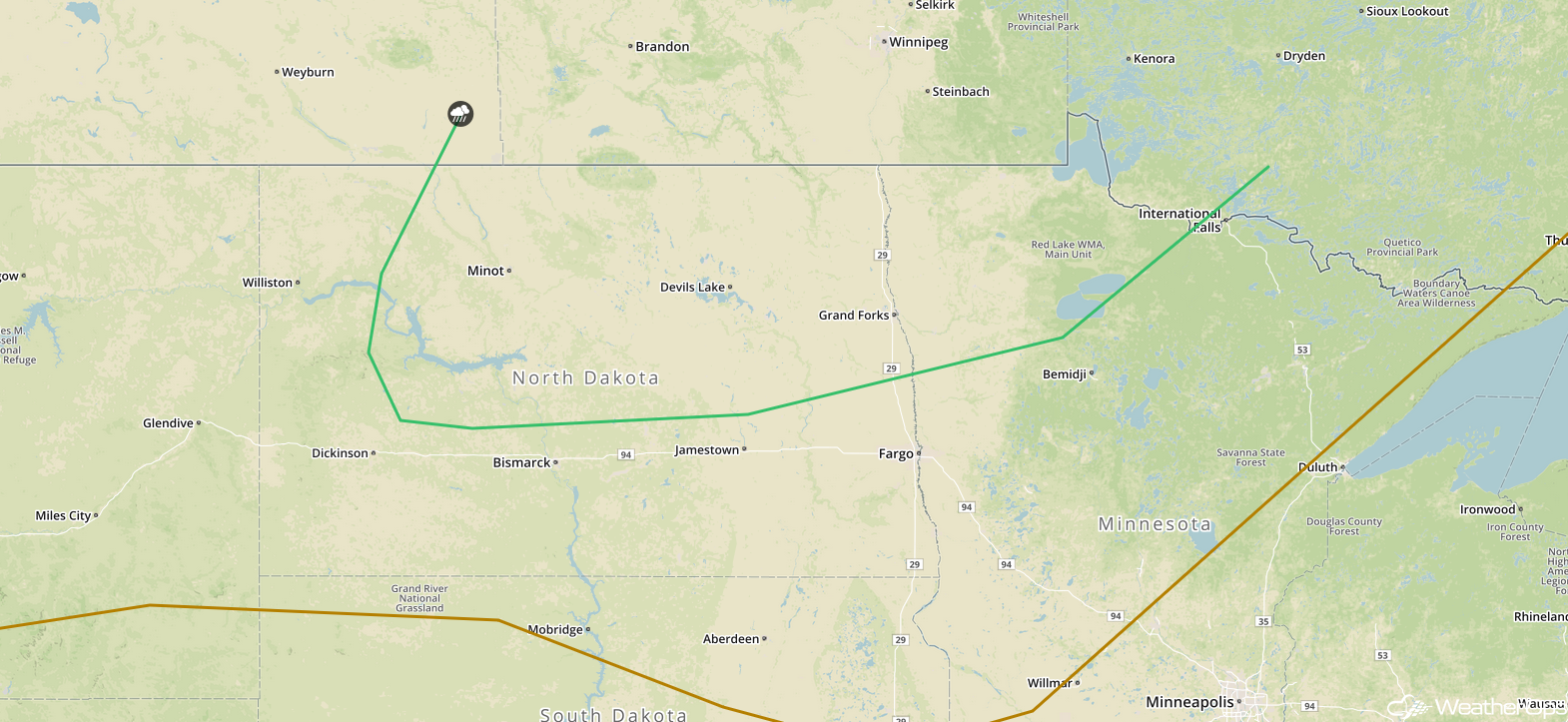
SPC Convective Outlook for Wednesday
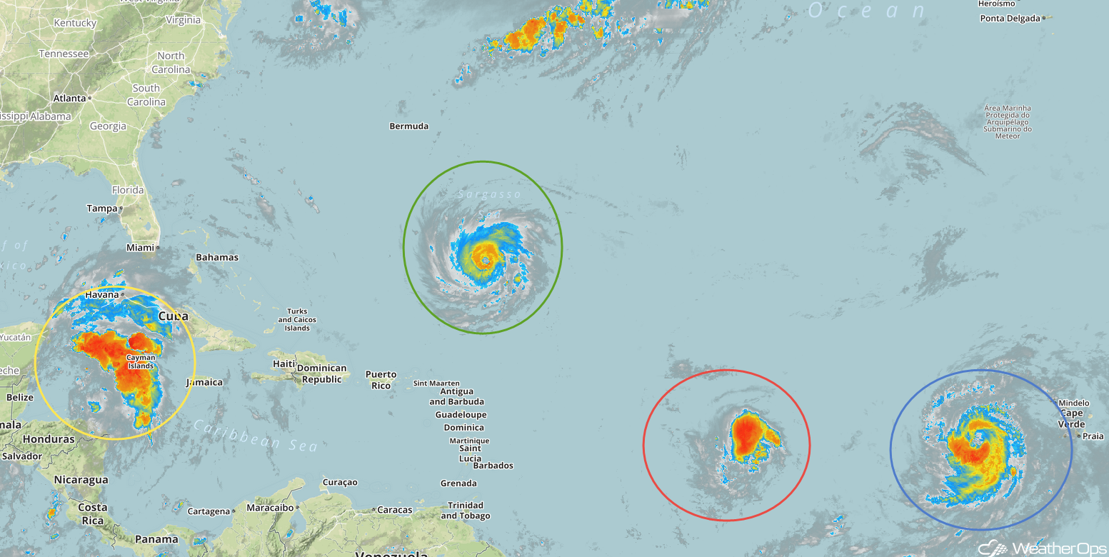
Tropical Update
Hurricane Florence (green oval) has rapidly strengthened into a a major hurricane with winds in excess of 130 mph and higher gusts. Florence is 580 miles south-southeast of Bermuda and is moving westward at 13 mph. A west-northwestward turn is expected with an increase in forward speed during the next couple of days. Florence is expected to turn toward the northwest late Wednesday night. On the current forecast track, the center of Florence will move between the Bahamas and Bermuda Tuesday and Wednesday and approach the Carolina coast on Thursday. Further strengthening is expected.
Hurricane Isaac (red oval) is 1150 miles east of the Windward Islands and is moving westward at 14 mph. This general motion with an increase in forward speed is expected to continue through the end of the week. On the current forecast track, Isaac should move across the Lesser Antilles and eastern Caribbean on Thursday. Sustained winds are at 75 mph with higher gusts. Some strengthening is expected over the next day or so. As it approaches the Lesser Antilles by the middle of the week, Isaac is expected to weaken.
Enhanced Infrared Satellite
Hurricane Helene (blue oval) is 375 miles west of the Cabo Verde Islands and is moving west-northwestward at 16 mph. This motion is expected to continue through late Tuesday, with a turn toward the north-northwest on Wednesday. Maximum sustained winds are near 105 mph with higher gusts. Some strengthening is expected today and Helene is expected to become a major hurricane by tonight. Weakening is expected to begin by late Tuesday.
Disorganized showers and thunderstorms over the northwestern Caribbean (yellow oval) are associated with a weak area of low pressure. This disturbance is forecast to move across the northwestern Caribbean and the Yucatan Peninsula over the next few days with slow development expected. Upper level winds could become more conducive for development late this week as the system moves into the western Gulf of Mexico.
A Look Ahead
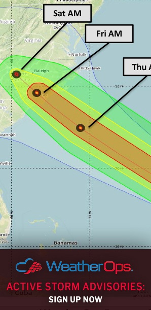
On Thursday, Hurricane Florence is forecast to make landfall along the coast of the Carolinas. While the exact track still remains uncertain, rainfall amounts of 12-16 inches with locally higher amounts in excess of 20 inches are forecast for portions of the Carolinas and Virginia through Sunday.
Elsewhere, showers and thunderstorms may develop across the Northern Plains and Upper Midwest on Thursday ahead of a cold front. By Friday, tropical moisture may allow for some heavy rain across southern Texas, This rainfall may continue into Saturday. Another round of showers and thunderstorms may develop Saturday across the Upper Midwest . By Sunday, thunderstorms will extend from the Great Lakes into the Central Plains.