National Weather Summary for Monday, October 3, 2016
by David Moran, on Oct 3, 2016 11:42:59 AM
An area of low pressure, cold front, and dryline will move into the Great Plains on Monday, allowing for the the development of thunderstorms. Into Tuesday, thunderstorms are expected across portions of the Plains a strong upper level trough will move across portions of the Central US. As a cold front moves into the Midwest, heavy rainfall will be possible across portions of the Central Plains. High elevation snow is expected across western Montana on the backside of a low moving into the Plains. Thunderstorms will once again be possible Wednesday for portions of the Central Plains as an upper level trough continues to move eastward.
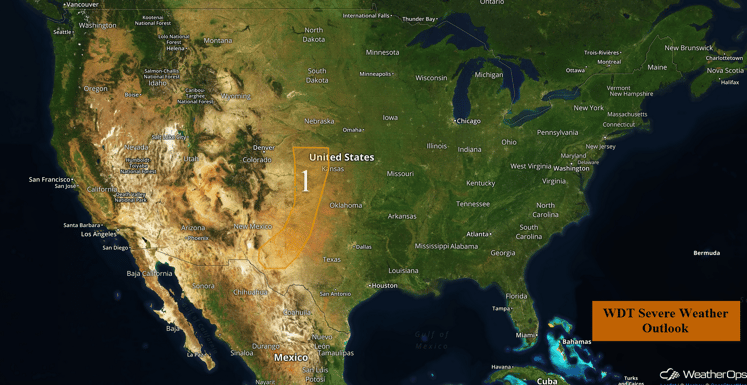
US Hazards
Region 1
A narrow region of instability is forecast across portions of the Central and Southern Plains to the east of a lee trough and dryline. With marginal moisture and daytime heating, there will be the potential for strong to severe thunderstorms across Region 1 into the afternoon and early evening The primary threats with any storms that develop will be strong gusty winds and large hail.
Update 2:20pm CDT: Severe Thunderstorm Watch in effect for portions of Montana, North Dakota, South Dakota, and Nebraska until 10pm CDT.
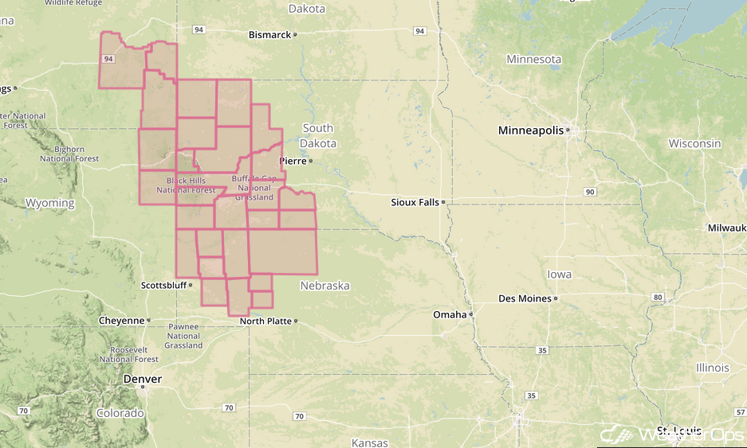
Major Cities in Region: Odessa, TX, Lubbock, TX, Amarillo, TX, Dodge City, KS, Goodland, KS
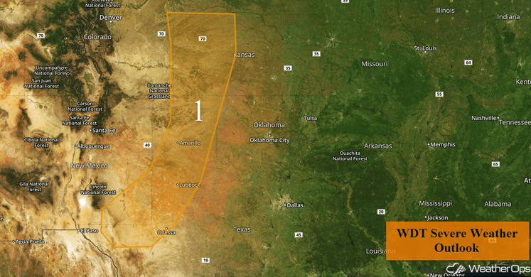
Region 1
Severe Thunderstorms Expected across the Great Plains on Tuesday
A strong upper level trough, along with a series of disturbances, is forecast to move across the Central US. At the surface, an eastward advancing cold front will provide a focus for the development of thunderstorms across the region. Due to increasing moisture and instability ahead of the front, conditions are expected to become favorable for severe thunderstorms, with supercells possible. All severe hazard will be possible, including large hail, damaging winds, and tornadoes. The greatest severe threat is expected to be across portions of Kansas and Oklahoma.
Major Cities in Region: Oklahoma City, OK, Tulsa, OK, Wichita, KS, Kansas City, MO, Omaha, NE, Des Moines, IA, Sioux Falls, SD
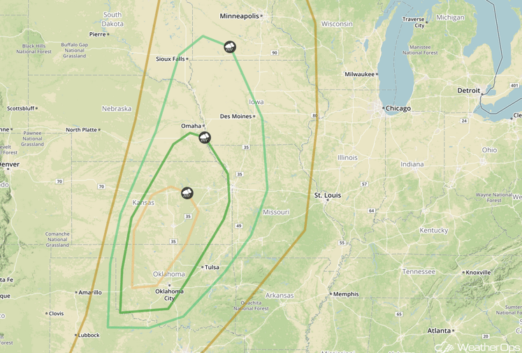
SPC Convective Outlook for Tuesday
Excessive Rainfall Possible Tuesday for Central Plains and Upper Midwest
A cold front advancing eastward across the Great Plains and into the Midwest will produce showers and thunderstorms throughout the day Tuesday, with the heaviest activity expected during the evening and overnight hours. Due to increasing moisture ahead of the front, there will be a potential for excessive rainfall across the region. General rainfall amounts of 1-2 inches will be possible, with locally higher amounts in excess of 3 inches.
Major Cities in Region: Kansas City, MO, Omaha, NE, Des Moines, IA, Sioux Falls, SD, Minneapolis, MN
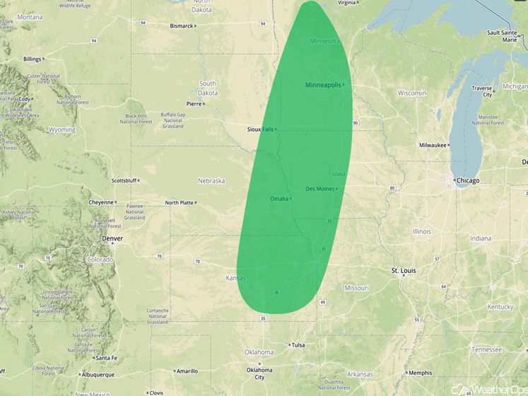
Excessive Rainfall Risk Outline for Tuesday
Significant Snowfall Possible across Western Montana on Tuesday
Precipitation on the backside of a departing surface low is expected to transition to all snow by early Tuesday across the higher elevations of western Montana mainly above 4500 feet. Snowfall accumulations of 8-16 inches with locally higher amounts in excess of 20 inches, and may lead to hazardous weather conditions across the region. Precipitation should remain mostly rain at lower elevations.
Major Cities in Region: Butte, MT, Great Falls, MT, Billings, MT, Glasgow, MT
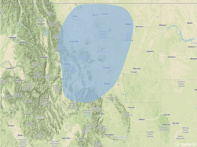
Significant Snowfall Risk Outline for Tuesday
Strong to Severe Thunderstorms Possible Wednesday for Central US
A strong upper level trough will continue progressing eastward on Wednesday, with an associated cold front providing a focus for the development across portions of the Central Plains eastward into the mid-Mississippi Valley. Thunderstorms may be ongoing early in the morning with additional development possible later in the day. Storms that develop in the afternoon and evening may be initially isolated in nature, but could evolve into a more organized complex during the overnight hours. There is a marginal risk of severe thunderstorms on Wednesday with gusty winds and hail the primary hazards.
Major Cities in Region: Kansas City, MO, Joplin, MO, Des Moines, IA, Cedar Rapids, IA
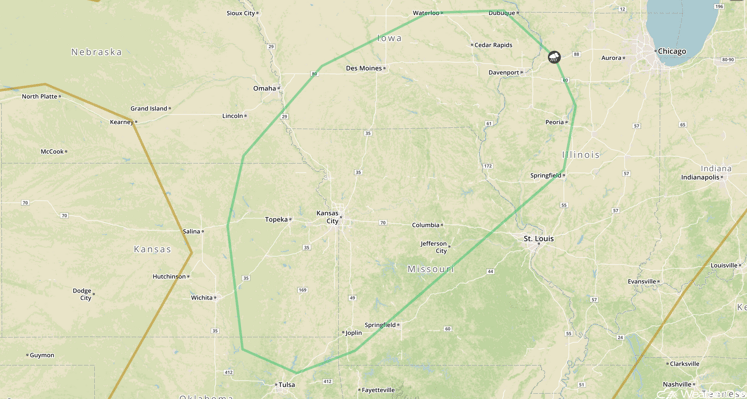
SPC Convective Outlook for Wednesday
Tropical Update
Hurricane Matthew (red oval) is moving toward the north at 6 mph and this general motion is expected to continue through Wednesday with an increase in forward speed tonight. On the forecast track, the center of Matthew will approach southwestern Haiti tonight and move near or over portions of the southeastern and central Bahamas Tuesday night and Wednesday. Matthew is a category 4 hurricane and some fluctuations are possible over the next few days, but Matthew is expected to remain a major hurricane through Wednesday.
A broad area of low pressure (green oval) located about 400 miles northeast of the northern Leeward Islands continues to produce disorganized showers and thunderstorms. Some development of this low is possible during the next couple of days before upper level winds become unfavorable for development. This system is expected to move west-northwestward to northwestward at 10-15 mph during the next few days.
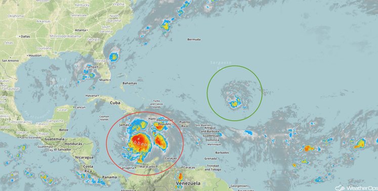
Tropical Infrared Satellite
A Look Ahead
Hurricane Matthew will need to be monitored along the East Coast by the end of the week with the potential for tropical storm conditions along the coast. Elsewhere, thunderstorms will be possible for portions of the Plains on Thursday as an area of low pressure and cold front moves across the region.
This is just a brief look at current weather hazards. We can provide you site-specific forecast information for the purpose of protecting your personnel and assets. Try a 7-day demo right away and learn how timely precision weather information can enhance your bottom line.


