


by David Moran, on Mar 26, 2018 11:24:38 AM
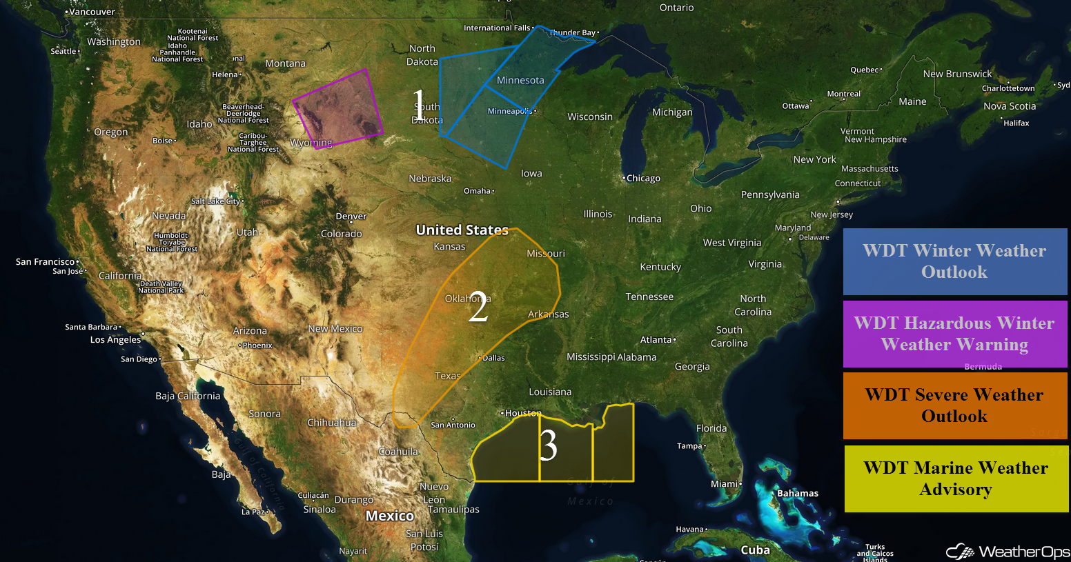
Freezing rain and snow will continue for portions of the Northern Plains through Monday evening as an upper level system moves through the region. Thunderstorms may develop Monday across the Southern Plains in association with an area of low pressure. Excessive rainfall is expected across the Southern Plains, Mississippi Valley, and Midwest through Wednesday. Elevated winds and seas are forecast for portions of the Gulf of Mexico Monday night through Wednesday night.
- Freezing Rain and Snow Continuing for the Northern Plains through Monday Evening
- Thunderstorms Monday for the Southern Plains
- Excessive Rainfall through Wednesday for the Southern Plains, Mississippi Valley, and Midwest
- Elevated Winds and Seas for Portions of the Gulf of Mexico Monday Night through Wednesday Night
- Risk for Thunderstorms Tuesday from Texas into Arkansas
- Thunderstorm Potential from Texas through Louisiana on Wednesday
 US Hazards

Freezing Rain and Snow Continuing for the Northern Plains through Monday Evening
The potential for freezing rain and snow will continue for portions of the Northern Plains on Monday as an area of low pressure continues to move eastward. Across the lower elevations of Wyoming, 4-6 inches of snow with locally higher amounts in excess of 8 inches are forecast. For the higher elevations, 5-10 inches of snow with locally higher amounts in excess of a foot are expected. Further east into the Northern Plains, snowfall accumulations will range 2-5 inches with locally higher amounts in excess of 6 inches. In addition, freezing rain may occur with accumulations ranging from a glaze to 0.15 inch. Activity will subside Monday night.
Major Cities in Region: Rapid City, SD, Sioux Falls, SD, Fargo, ND, Duluth, MN
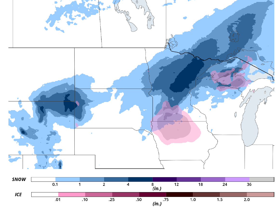 Snow and Ice Forecast for Monday
Thunderstorms Monday for the Southern Plains
Daytime heating and increased moisture ahead of a dryline will allow instability to build across western Oklahoma and the Texas Panhandle. The dryline will push slowly into West Central and Central Oklahoma. This will provide lifting for the development of scattered thunderstorms along and ahead of the dryline. Hail and damaging winds will be the primary hazards with these storms, but an isolated tornado or two cannot be ruled out. Storms will become more linear later in the evening with damaging winds becoming the primary hazard. These storms will slowly move to the northeast with the threat diminishing overnight.
Major Cities in Region: Del Rio, TX, Oklahoma City, OK, Dallas, TX, Tulsa, OK, Fort Smith, AR, Joplin, MO, Kansas City, MO
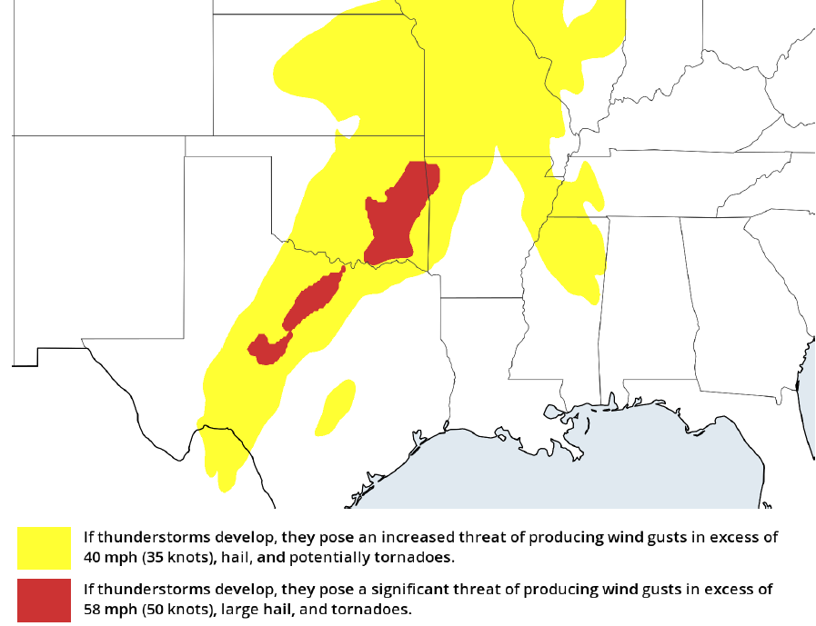 Thunderstorm Forecast for Monday
Excessive Rainfall through Wednesday for the Southern Plains, Mississippi Valley, and Midwest
As a cold front slowly progresses across the Central, Southern, and Midwestern US, areas of moderate to heavy showers and thunderstorms, some severe, are forecast to slowly move across the region. This will lead to a multi-day rainfall event. Three day rainfall totals of 1-3 inches with locally higher amounts in excess of 5 inches are forecast.
Major Cities in Region: Dallas, TX, Houston, TX, Little Rock, AR, St. Louis, MO, Memphis, TN, Jackson, MS
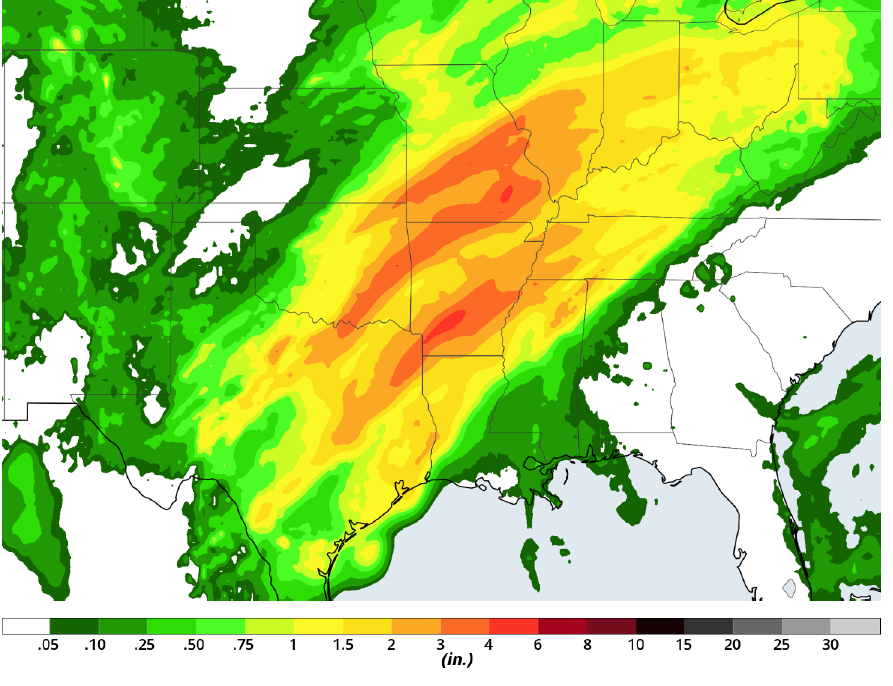 Rainfall Forecast for Monday through Wednesday
Elevated Winds and Seas for Portions of the Gulf of Mexico Monday Night through Wednesday Night
A prolonged period of elevated winds and seas is expected across portions of the Gulf of Mexico from Monday evening through Wednesday evening. Winds will range 20-27 knots with gusts in excess of 35 knots. Seas will range 5-7 feet near the shore and 7-9 feet in the deeper waters.
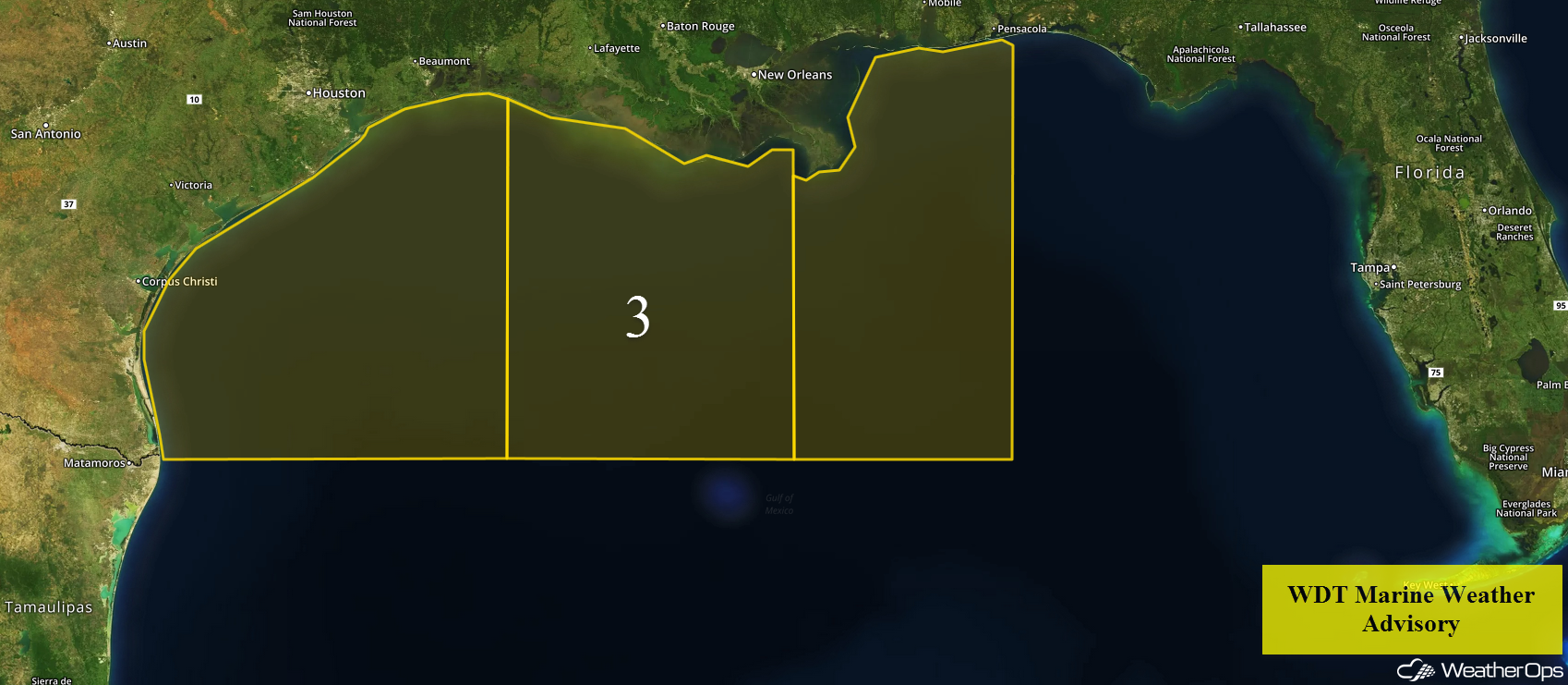 Region 3
Risk for Thunderstorms Tuesday from Texas into Arkansas
Thunderstorms will be ongoing across Arkansas into Texas early Tuesday. There will be the potential for new development during the afternoon, however, cloud cover and ongoing precipitation may decrease the overall threat. Large hail and damaging winds will be the primary hazards with these storms.
Major Cities in Region: Midland, TX, Del Rio, TX, San Antonio, TX, Dallas, TX, Little Rock, AR
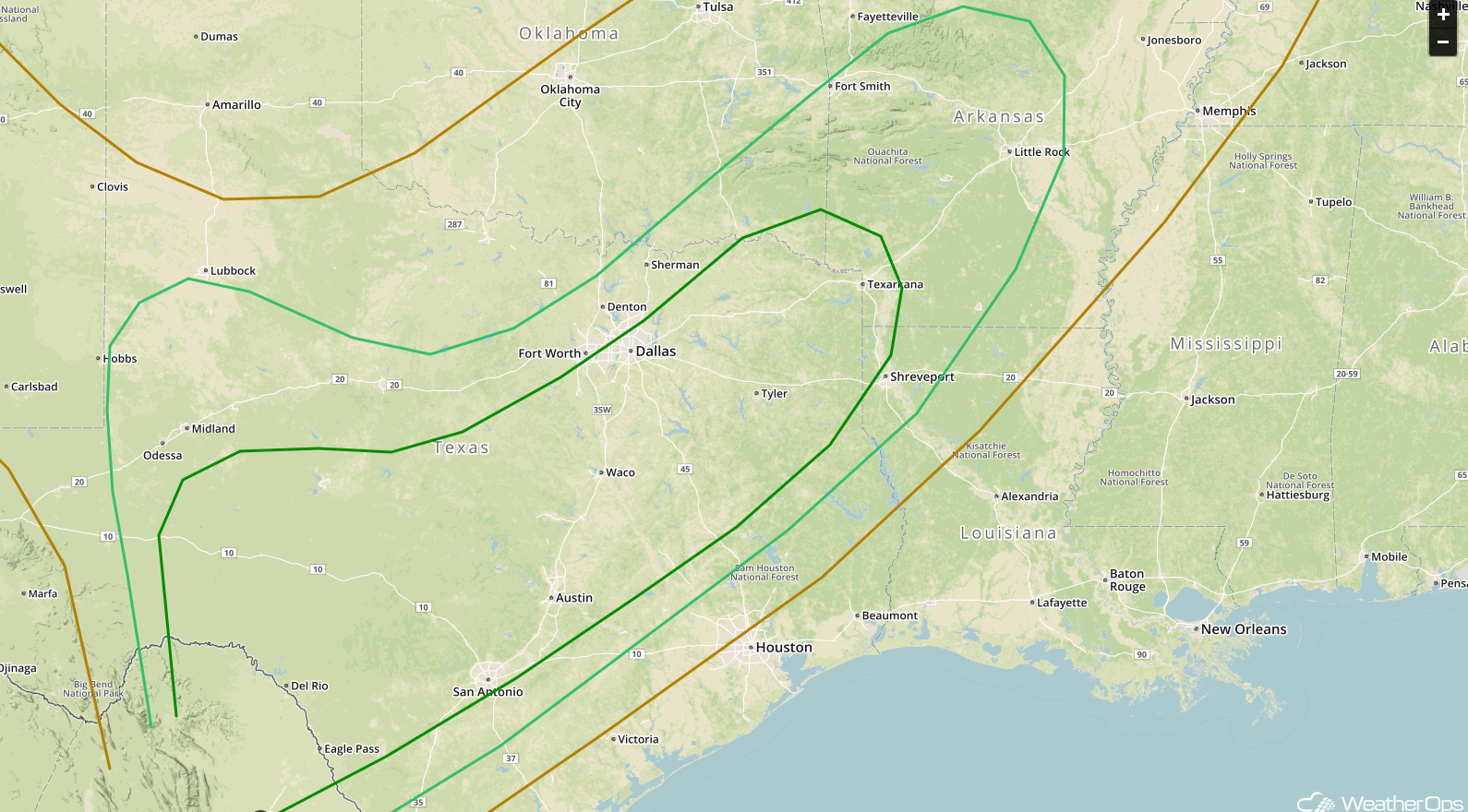 SPC Convective Outlook for Tuesday
Thunderstorm Potential from Texas through Louisiana on Wednesday
On Wednesday, thunderstorms across Texas will move into Louisiana. Some severe thunderstorms may develop overnight into the morning hours. Activity could re-intensify during the afternoon with large hail and damaging winds the primary hazards.
Major Cities in Region: San Antonio, TX, Austin, TX, Corpus Christi, TX, Houston, TX, Shreveport, LA, Jackson, MS
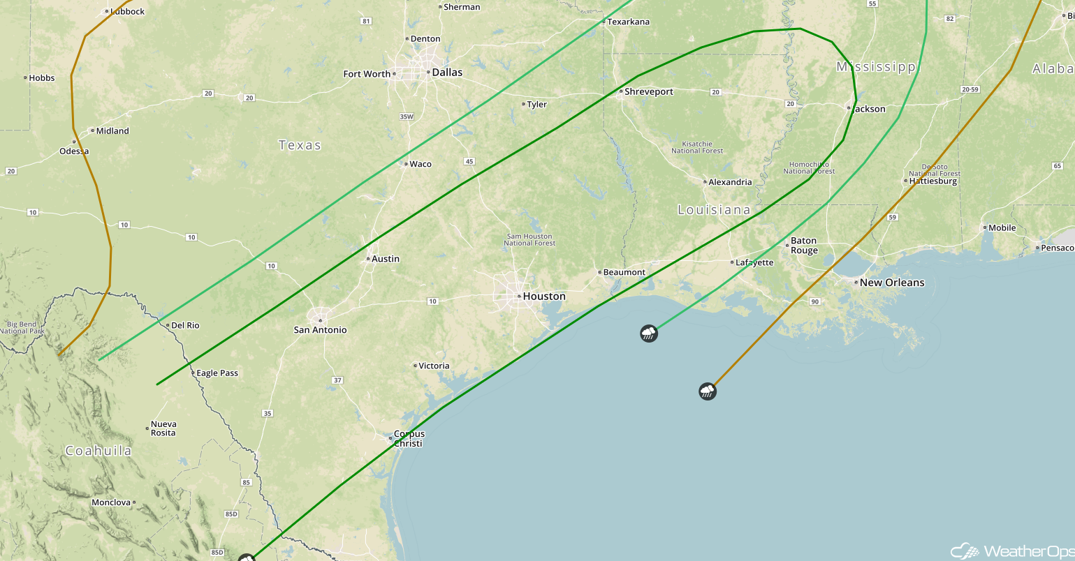 SPC Convective Outlook for Wednesday
A Look Ahead
An area of low pressure moving through the Northern Plains may bring snow to the region on Saturday. While there is still some uncertainty in the forecast, there will be the potential for several inches of snow.
This is just a brief look at current weather hazards. We can provide you site-specific weather forecast information for the purpose of protecting your personnel and assets and to assess your weather risk. Try a 7-day demo right away and learn how timely precision weather information can enhance your bottom line.
