National Weather Summary for Monday, June 5, 2017
by David Moran, on Jun 5, 2017 11:31:28 AM
A cold front associated with an area of low pressure moving through the Northeast will allow for the development of thunderstorms on Monday from the Northeast into the Southeast. Thunderstorms may develop across the Northern Plains as an upper level disturbance tracks toward Manitoba on Monday. Deep moisture and forcing from an area of low pressure will create an environment for thunderstorms Monday across South Texas.
- Thunderstorms Monday from the Northeast into the Ohio Valley
- Strong to Severe Thunderstorms Possible across the High Plains on Monday
- Thunderstorm Potential Monday for South Texas
- Thunderstorms for the Carolinas on Monday
- Strong to Severe Thunderstorms Possible Monday for South Florida
- Potential for Thunderstorms across the High Plains on Tuesday
- Risk for Thunderstorms Tuesday across the Southeast
- Thunderstorms for the Southern High Plains on Wednesday
- Excessive Rainfall Possible Wednesday across Florida
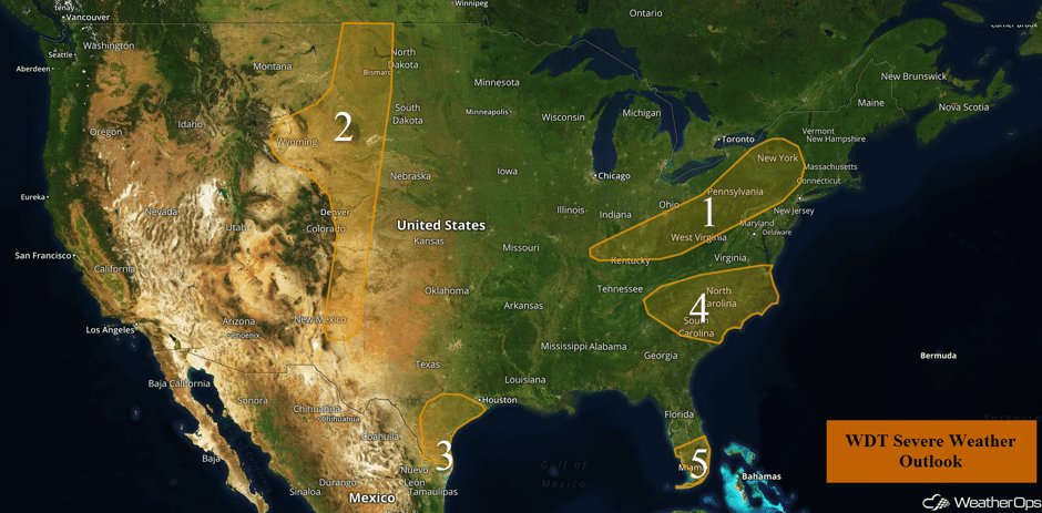 US Hazards
Thunderstorms Monday from the Northeast into the Ohio Valley
A slow moving cold front tracking southeastward across the Northeast and Ohio Valley will be the focus for thunderstorm development on Monday. Most activity should taper off after sunset as instability decreases with the loss of daytime heating. Large hail, damaging winds, and tornadoes will all be possible with any storms that develop.
Update 2pm EDT: Severe thunderstorm capable of damaging winds north of Oneonta, NY.
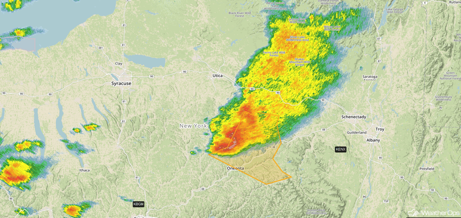 Radar 2pm EDT
Update 2:05pm EDT: Severe thunderstorm capable of large hail and damaging winds SW of Binghamton, NY.
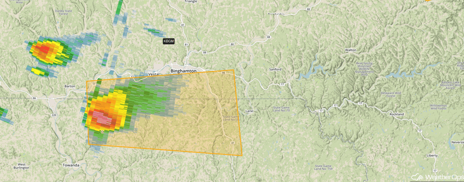 Radar 2:05pm EDT
Major Cities in Region: Evansville, IN, Cincinnati, OH, Charleston, WV, Pittsburgh, PA, Syracuse, NY
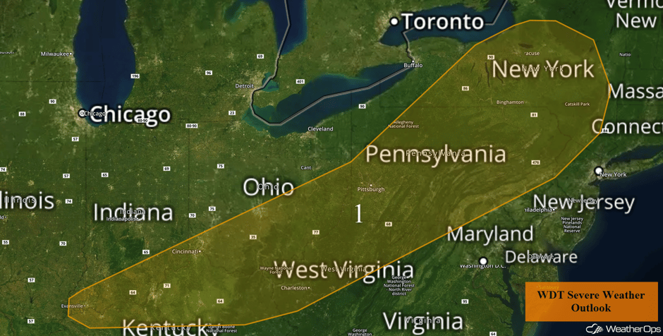 Region 1
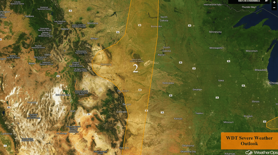
Strong to Severe Thunderstorms Possible across the High Plains on Monday
An area of low pressure and associated cold front moving into the Rockies and High Plains is expected to generate isolated to scattered thunderstorms across the region today. Gusty winds and hail will be the primary hazards with these storms.
Major Cities in Region: Denver, CO, Cheyenne, WY, Roswell, NM, Rapid City, SD
 Region 2
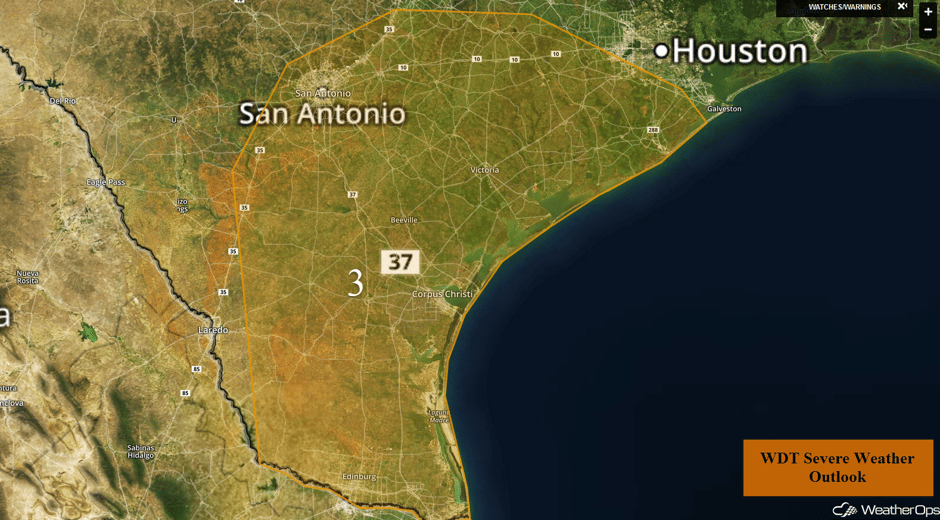
Thunderstorm Potential Monday for South Texas
A broad upper level trough moving southward across the south central US is likely to produce scattered showers and thunderstorms across portions of South Texas today. Thunderstorms will be possible this morning through the late evening and overnight hours. Large hail, damaging winds, and isolated tornadoes will be possible with any storms that develop.
Major Cities in Region: San Antonio, TX, Corpus Christi, TX, Brownsville, TX
 Region 3
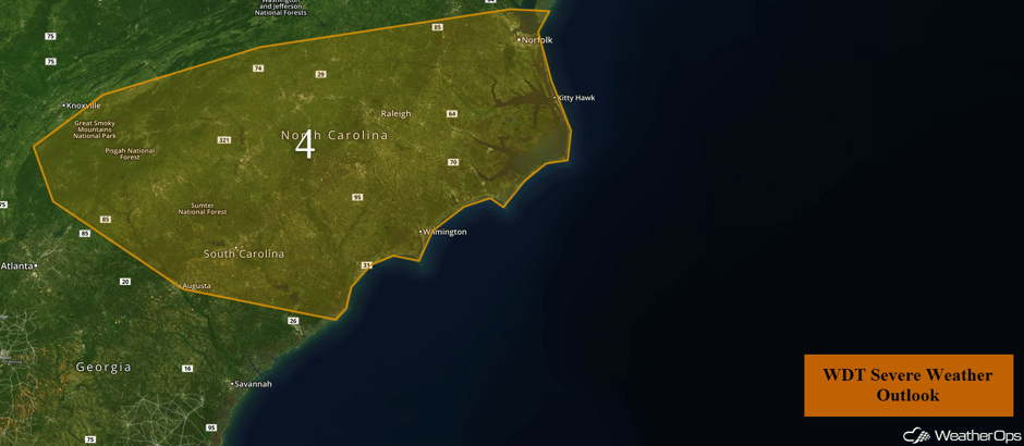
Thunderstorms for the Carolinas on Monday
A cold front is forecast to develop later today east of the Appalachians as an area of low pressure slides off to the northeast. Thunderstorms are likely ahead of the cold front during the late afternoon or early evening before tapering off during the late evening. Gusty winds, hail, and tornadoes will all be possible with any storms that develop.
 Region 4
Major Cities in Region: Augusta, GA, Columbia, SC, Raleigh, NC, Norfolk, VA
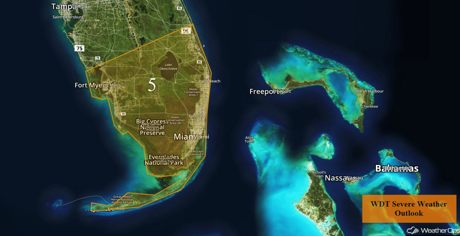
Strong to Severe Thunderstorms Possible Monday for South Florida
Weak upper level disturbances moving through the region will interact with deep tropical moisture and produce scattered thunderstorms across South Florida throughout the day, though most storms should begin to taper off after sunset. Conditions may become favorable for strong to severe thunderstorms with gusty winds and isolated tornadoes the primary hazards.
 Region 5
Major Cities in Region: Fort Myers, FL, Key West, FL, Miami, FL, Palm Beach, FL
Potential for Thunderstorms across the High Plains on Tuesday
Upslope flow is forecast to begin on Tuesday across eastern portions of New Mexico and with daytime heating creating ample instability across the region, favorable conditions will be in place for thunderstorm development Tuesday afternoon. Thunderstorms are forecast to form near the higher elevations across the Front Range and in New Mexico and track eastwards into the evening hours. These thunderstorms will quickly increase in strength with some of these storms becoming strong to severe in nature. The primary hazard with any strong to severe thunderstorms that do form will be large hail and damaging wind gusts.
Major Cities in Region: Santa Fe, NM, Denver, CO, North Platte, NE
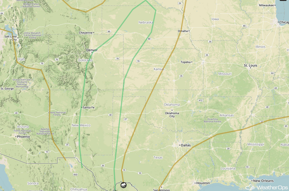 SPC Convective Outlook for Tuesday
Risk for Thunderstorms Tuesday across the Southeast
Across the Southeast, a cold front will slowly track through the region and a broad surface low will also begin to approach the region from the west. With the cold front and low close enough to each other widespread rain and thunderstorm activity is forecast to be ongoing during the morning hours across the Southeast. As we get into the afternoon and this aforementioned low tracks eastwards toward Florida, instability is forecast to begin to increase across the region. This instability combined with the ample forcing and deep moisture that’s already in place across the Southeast will lead to the strengthening of any early morning rain and thunderstorm activity with some of these storms becoming strong to severe in nature. Some damaging wind gusts and small hail would be the main threat with any stronger thunderstorms that do form. In addition to this thunderstorm activity, heavy to excessive rainfall will also be possible on Tuesday across portions of Florida. Forecast guidance currently suggests that slow moving rain and thunderstorms will produce widespread rainfall amounts of 1 to 2 inches, locally 3+, across the region and with the previous days rainfall already saturating the ground, excessive runoff and localized flooding look to be possible across the region.
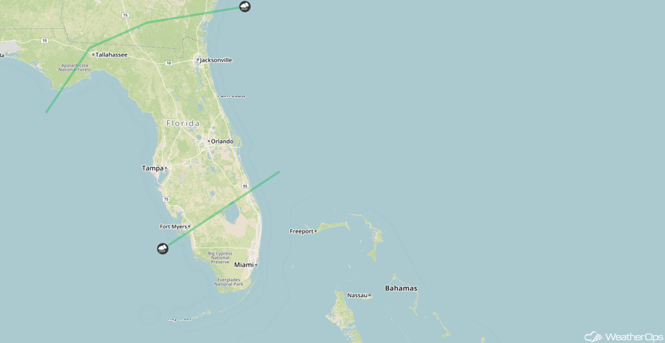 SPC Convective Outlook for Tuesday
Major Cities in Region: Tallahassee, FL, Tampa, FL, Orlando, FL, Jacksonville, FL, Savannah, GA
Thunderstorms for the Southern High Plains on Wednesday
Once again upslope flow across the mountains of New Mexico will persist on Wednesday and with ample low level moisture and instability spread across the area, some isolated to widely scattered strong to severe thunderstorms will be possible during the afternoon and evening. At this time, damaging wind gusts and large hail will be the primary concern with any severe thunderstorms that do form.
Major Cities in Region: El Paso, TX, Odessa, TX, Lubbock, TX, Amarillo, TX
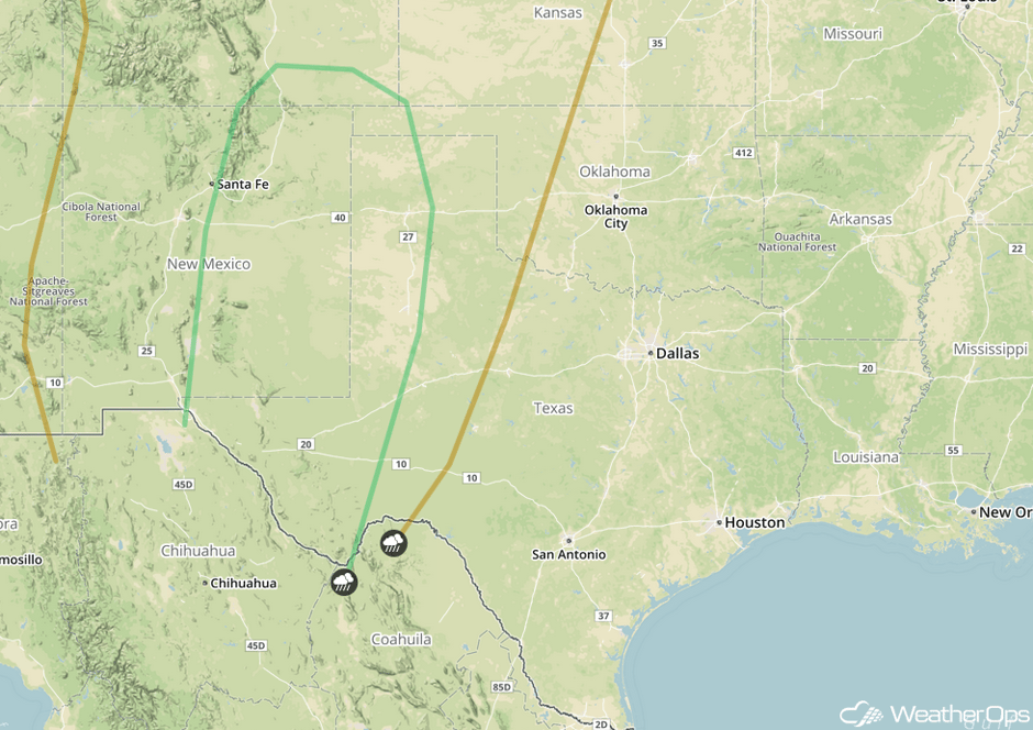 SPC Convective Outlook for Wednesday
Excessive Rainfall Possible Wednesday across Florida
Once again heavy rainfall and thunderstorms will continue to fall across portions of central and southern Florida as a frontal boundary slowly pushes southeastward across the state on Wednesday. Ample moisture will remain in place across the region. With the expected slow moving nature of any thunderstorm or shower in this region, heavy to excessive rainfall is likely to occur. Forecast guidance currently suggests that widespread rainfall amounts of 1 to 2 inches, locally 3+, across the region will be possible and with the previous days rainfall already saturating the ground, excessive runoff and localized flooding will be possible across the region.
Major Cities in Region: Tampa, FL, Fort Myers, FL
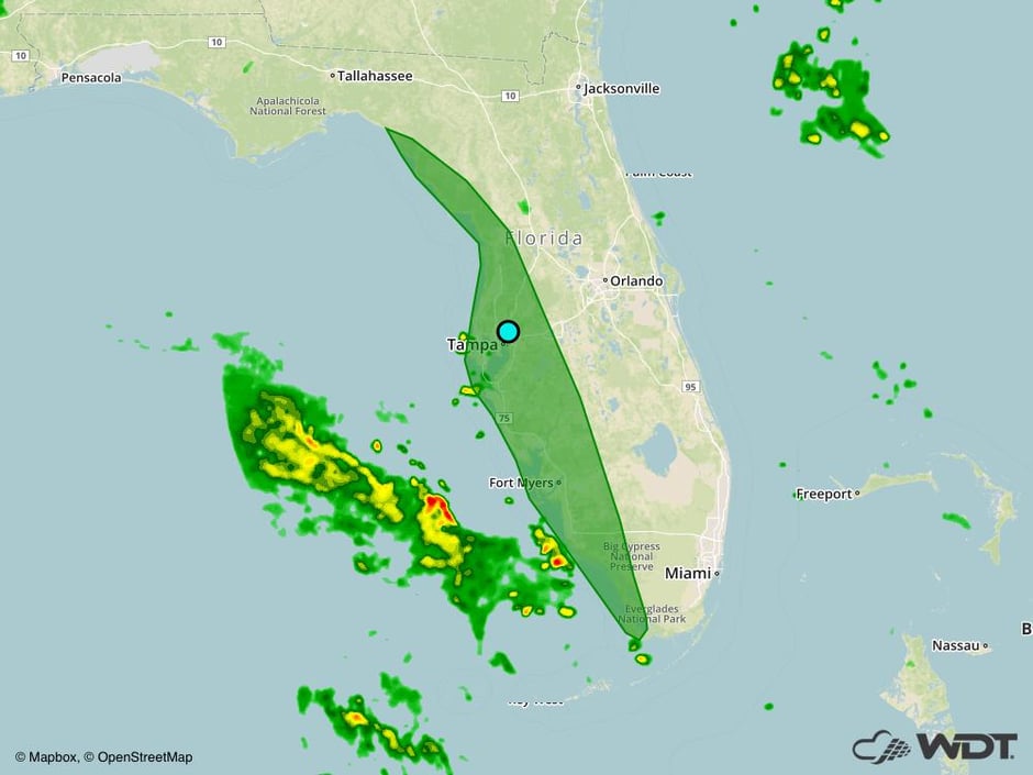 Excessive Rainfall Risk Outline for Wednesday
A Look Ahead
Fairly quiet conditions are expected for the latter part of the week. Thunderstorms and the risk for excessive rainfall will continue for Florida through Saturday. There will be a risk for thunderstorms across portions of the Dakotas on Saturday as a cold front moves into the Northern Plains.
This is just a brief look at current weather hazards. We can provide you site-specific weather forecast information for the purpose of protecting your personnel and assets and to assess your weather risk. Try a 7-day demo right away and learn how timely precision weather information can enhance your bottom line.


