


by David Moran, on Jun 4, 2018 10:40:19 AM
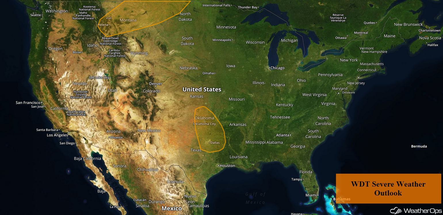
Thunderstorms are forecast across portions of Montana on Monday as an area of low pressure moves across the region. Across the Southern Plains, thunderstorms may develop along a dry line.
- Thunderstorms for Portions of Montana on Monday
- Risk for Thunderstorms Monday across the Southern Plains
- Thunderstorm Potential for the Northern Plains on Tuesday
- Thunderstorms Tuesday from Western Kansas into Northwest Texas
- Potential for Thunderstorms for the Arklatex Region on Tuesday
- Risk for Thunderstorms Wednesday from the Central Plains into the Upper Midwest
 US Hazards

Thunderstorms for Portions of Montana on Monday
An area of low pressure will intensify across the Northern Plains on Monday. At the surface, instability is expected to build along and to the south of a warm front. Thunderstorms are expected to develop during the afternoon. Severe wind and large hail will be the primary hazards with the stronger storms. An isolated tornado cannot be ruled out, especially during the evening hours.
Major Cities in Region: Butte, MT, Helena, MT, Great Falls, MT, Glasgow, MT
 Thunderstorm Risk for Monday
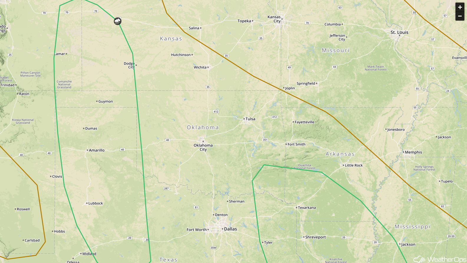
Risk for Thunderstorms Monday across the Southern Plains
Thunderstorms are forecast to develop across western Oklahoma and northwest Texas ahead of a dry line. Daytime heating and plentiful moisture in place will allow instability to build through the afternoon. While thunderstorm coverage may be limited, severe winds and large hail will be the primary hazards with any storms that develop.
Major Cities in Region: Lubbock, TX, Amarillo, TX, Lawton, OK, Dallas, TX, Tyler, TX
 Thunderstorm Risk for Monday
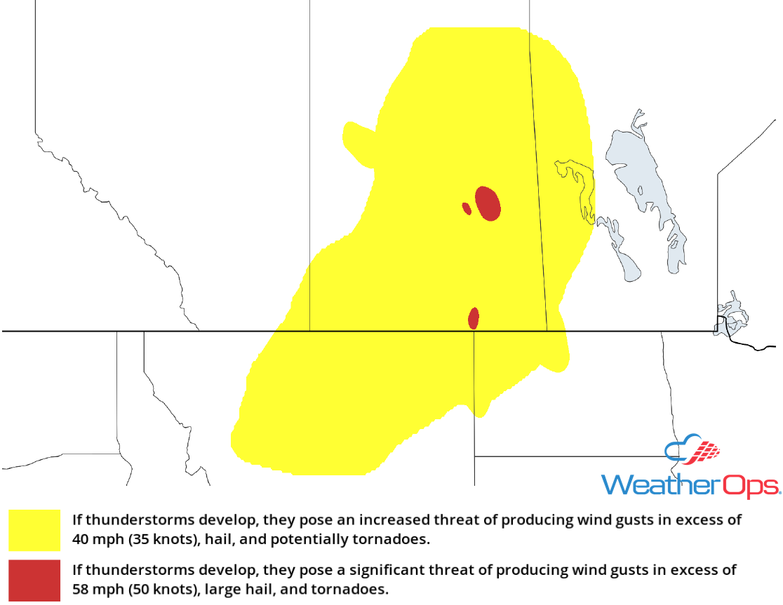
Thunderstorm Potential for the Northern Plains on Tuesday
The area of low pressure over the Northern Plains described above will continue to move eastward on Tuesday. With abundant moisture and strong wind shear in place, there will be the potential for severe thunderstorms. Large hail and damaging winds will be the primary hazards with these storms, but an isolated tornado or two cannot be ruled out. The greatest threat will stretch across the Dakotas. Storms will eventually merge into a line after dark and track southeastward across Minnesota. Severe winds will be the primary hazard into the overnight hours.
Major Cities in Region: Rapid City, SD, Minot, ND, Bismarck, ND, Pierre, SD, Fargo, ND
 SPC Convective Outlook for Tuesday
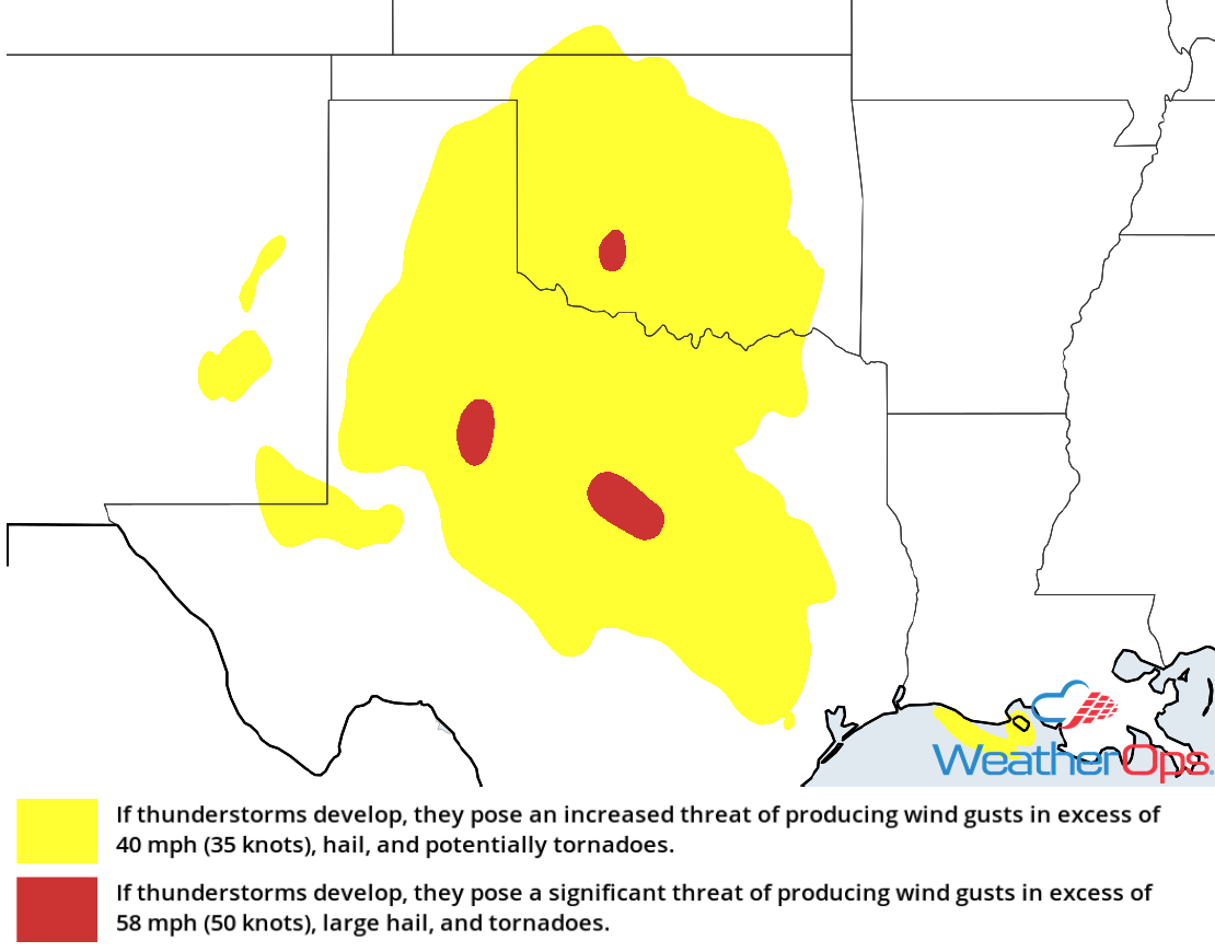
Thunderstorms Tuesday from Western Kansas into Northwest Texas
Thunderstorms may develop from western Kansas into Northwest Texas along the dryline on Tuesday . While significant severe weather is not anticipated, some storms could become severe with large hail and damaging winds the primary hazards. A few storms may continue to move eastward across Central Texas into the overnight hours.
Major Cities in Region: Lubbock, TX, Amarillo, TX, Guymon, OK, Goodland, KS
 SPC Convective Outlook for Tuesday
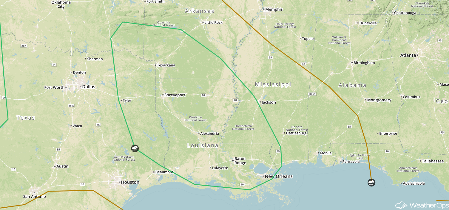
Potential for Thunderstorms for the Arklatex Region on Tuesday
Showers and thunderstorms should be ongoing during the morning hours across the Arklatex region on Tuesday; some of these storms could be marginally severe through the morning hours. Large hail and damaging winds will be the primary hazards with these storms. Activity should weaken or move out of the area by the early afternoon.
Major Cities in Region: Tyler, TX, Texarkana, AR, Shreveport, LA
 SPC Convective Outlook for Tuesday
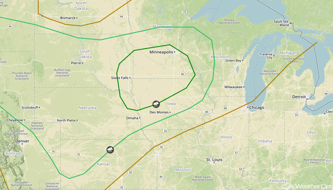
Risk for Thunderstorms Wednesday from the Central Plains into the Upper Midwest
Strong instability will build across portions of Nebraska and South Dakota northeastward into Southern Minnesota as a result of daytime heating and plentiful moisture. While wind shear will be somewhat weak, thunderstorms capable of large hail and severe winds may develop. There will also be a risk for thunderstorms from the Northern High Plains southward into the Colorado Front Range and Northwest Kansas, but the threat in this area will be lower.
Major Cities in Region:Scottsbluff, NE, Goodland, KS, North Platte, NE, Pierre, SD, Sioux Falls, SD, Omaha, NE, Des Moines, IA, Minneapolis, MN
 SPC Convective Outlook for Wednesday
A Look Ahead
An area of low pressure may develop over the Northern High Plains on Thursday, allowing for the development of showers and thunderstorms across portions of the Northern Plains and Upper Midwest. This activity will move into the Great Lakes on Friday. Additional thunderstorms may develop over the Northern Plains and Upper Midwest Friday evening into the overnight hours. By the weekend, showers will move into the Lower Great Lakes and Ohio River Valley.
This is just a brief look at current weather hazards. We can provide you site-specific weather forecast information for the purpose of protecting your personnel and assets and to assess your weather risk. Try a 7-day demo right away and learn how timely precision weather information can enhance your bottom line.
