National Weather Summary for Monday, June 12, 2017
by David Moran, on Jun 12, 2017 11:26:57 AM
Severe thunderstorms are expected Monday from the Northern Rockies into the High Plains as a warm front moves northward across the region. A stalled front will be the focus for thunderstorms across the Upper Midwest today. A weak upper level system may allow for some strong to severe thunderstorms during the day across Maine. Thunderstorms may develop across portions of West Texas during the afternoon.
- Severe Thunderstorms Expected Monday from the Northern Rockies into the High Plains
- Thunderstorm Potential across the Northern Plains and Upper Midwest on Monday
- Strong to Severe Thunderstorms Possible across West Texas on Monday
- Thunderstorms Monday across Maine
- Potential for Thunderstorms Tuesday across the Northern and Central Plains
- Risk for Excessive Rainfall across Montana and northern Wyoming on Tuesday
- Thunderstorm Risk Wednesday across the Midwest
- Severe Thunderstorms Expected across Minnesota and Northern Iowa on Wednesday
- Strong to Severe Thunderstorm Risk Wednesday for the Ohio Valley and Mid Atlantic
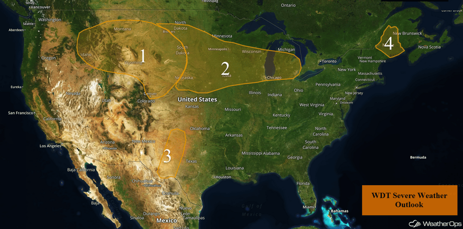 US Hazards
Severe Thunderstorms Expected Monday from the Northern Rockies into the High Plains
Severe weather is expected across the northern High Plains and into the higher terrain of the Northern Rockies on Monday. Warm and moist air will stream northward as an area of low pressure intensifies over the east side of the Rockies. A large upper level low will move into the region, which will combine with the unstable air to produce a favorable environment for severe thunderstorms. Scattered thunderstorms are expected to develop by the afternoon hours across western portions of the region and expand eastward throughout the day and evening. Initially, the primary hazards will be large hail and strong tornadoes. As activity shifts eastward into the Dakotas, large hail and damaging winds will be the primary hazards into the overnight hours.
Update 10:46am MDT: Severe thunderstorms capable of large hail in SE Idaho.
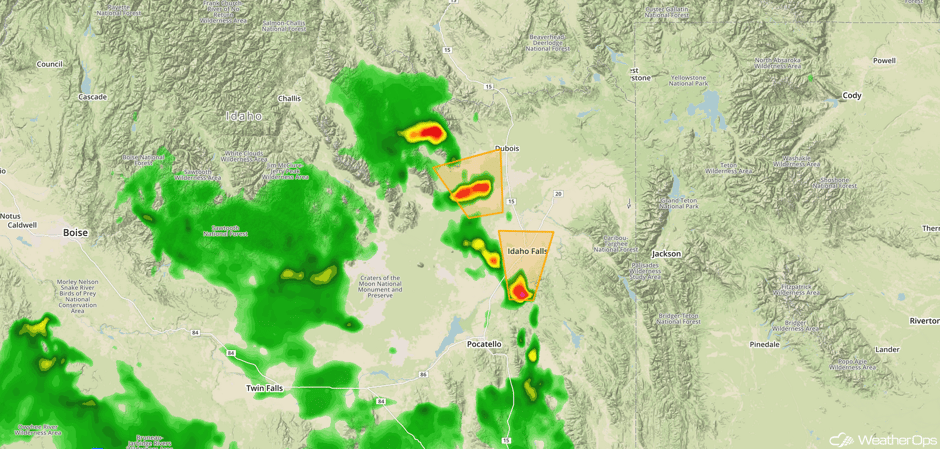 Radar 10:46am MDT
Update 12:40pm MDT: Severe thunderstorm in southeastern Idaho capable of hail and damaging winds.
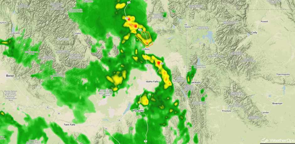 Radar 12:40pm MDT
Major Cities in Region: Helena, MT, Billings, MT, Cheyenne, WY, Denver, CO, Pierre, SD
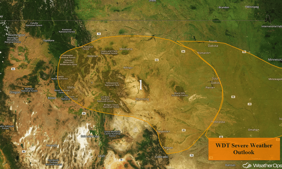 Region 1
Thunderstorm Potential across the Northern Plains and Upper Midwest on Monday
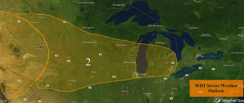
There is a chance for strong to severe thunderstorms across the Northern Plains into the Midwest on Monday. An area of low pressure will intensify over the Plains during the day with a front expected to stall and be draped across the Northern Plains into Iowa and southern Wisconsin for much of the day. Ongoing storms over eastern Nebraska will gradually weaken through the morning hours, with additional development expected along the front during the late afternoon. Large hail, damaging winds, and isolated tornadoes will be the primary hazards with these storms. Activity will be scattered in nature and will shift southeastward into the evening with damaging winds being the primary hazard from Iowa into Chicago.
Update 11:36am CDT: Severe thunderstorm capable of hail and damaging winds in north central Iowa.
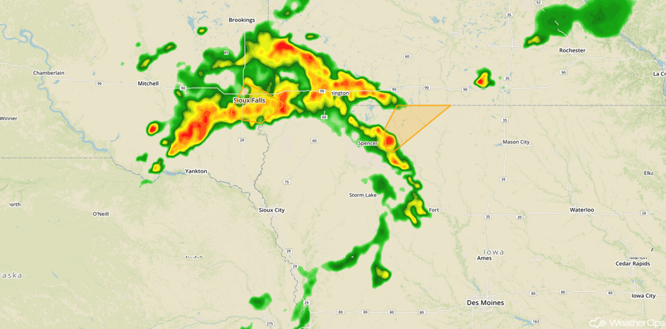 Radar 11:36am CDT
Update 11:54am CDT: Severe Thunderstorm Watch for portions of Iowa and Minnesota until 7pm CDT.
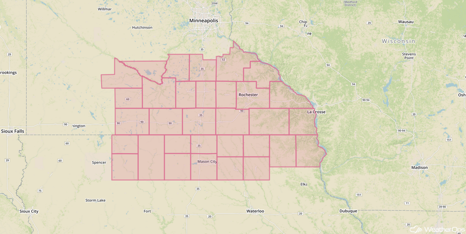 Severe Thunderstorm Watch
Update 12:12pm CDT: Severe thunderstorm capable of damaging winds SE of Sioux Falls, SD.
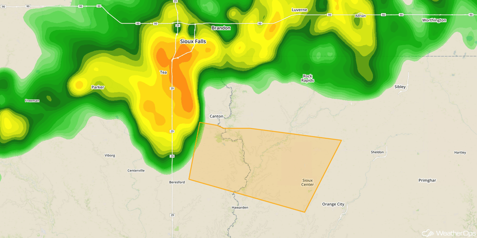 Radar 12:12pm CDT
Update 1:01pm CDT: Severe thunderstorms capable of large hail and damaging winds moving eastward across southern Minnesota.
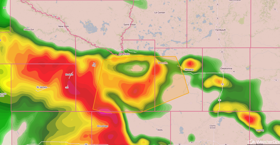 Radar 1:01pm CDT
Major Cities in Region: Bismarck, ND, Omaha, NE, Minneapolis, MN, Milwaukee, WI, Chicago, IL, Detroit, MI
 Region 2
Strong to Severe Thunderstorms Possible across West Texas on Monday
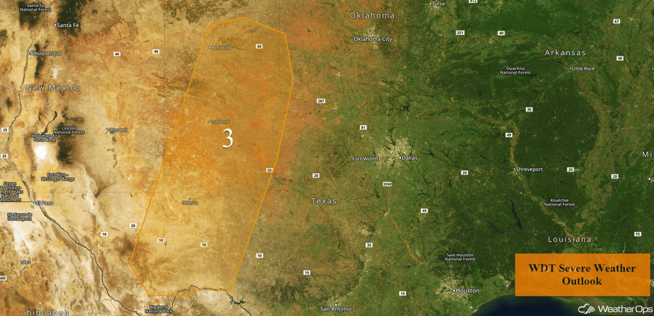
Daytime heating and sufficient moisture in West Texas will create enough instability for a few widely scattered thunderstorms to develop along a dryline late this afternoon. Storms will likely weaken after sunset with the loss of daytime heating.
Major Cities in Region: Odessa, TX, Amarillo, TX, Lubbock, TX
 Region 3
Thunderstorms Monday across Maine
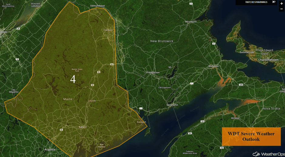
Isolated severe thunderstorms may develop during the morning into the late afternoon. Sufficient moisture and daytime heating will create instability. With a weak upper level disturbance approaching, conditions will be favorable for the development of thunderstorms.
Major Cities in Region: Bangor, ME, Caribou, ME
 Region 4
Potential for Thunderstorms Tuesday across the Northern and Central Plains
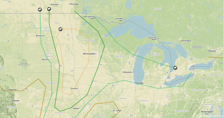
A broad area of low pressure over the Dakotas and a trailing cold front extending into the Oklahoma Panhandle may allow for the development of strong to severe thunderstorms. This threat is dependent upon ongoing showers and thunderstorms in the morning. If thunderstorms struggle to move out of the Dakotas, further thunderstorm development may be hampered later in the day. Nevertheless, isolated severe thunderstorms capable of large hail and damaging winds are expected across the Dakotas by mid-afternoon before spreading into Minnesota and western Wisconsin during the evening. A few tornadoes may also develop. In addition, heavy rain and isolated flash flooding may accompany these storms. Further south, isolated severe thunderstorms may develop ahead of a dryline late in the afternoon into the early evening.
Major Cities in Region: Bismarck, ND, Omaha, NE, Minneapolis, MN, Milwaukee, WI, Chicago, IL, Detroit, MI
 SPC Convective Outlook for Tuesday
Risk for Excessive Rainfall across Montana and northern Wyoming on Tuesday
Unseasonably high moisture content will wrap around a large area of low pressure forecast to move across eastern Montana and the Dakotas Tuesday through Tuesday night. Persistent moderate to heavy rain is likely across much of Montana and northern Wyoming. Widespread rainfall amounts of 2-3 inches with isolated higher amounts in excess of 4 inches will result in isolated flash flooding,
Major Cities in Region: Missoula, MT, Helena, MT, Great Falls, MT
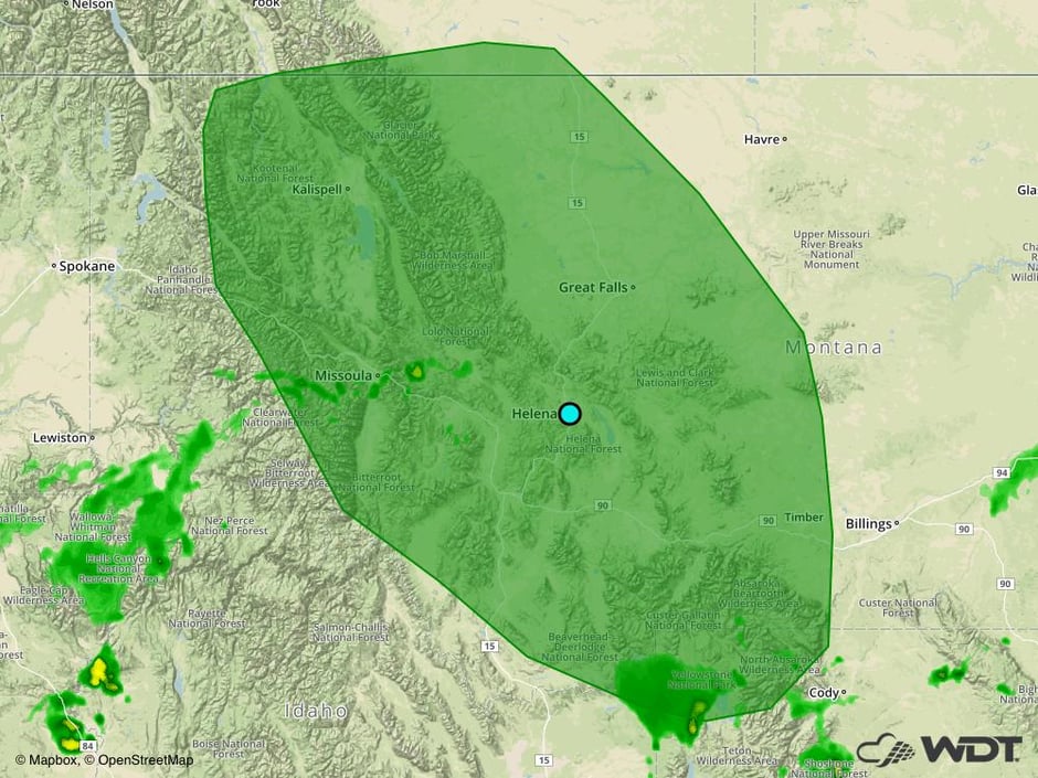 Excessive Rainfall Risk Outline for Tuesday
Thunderstorm Risk Wednesday across the Midwest
A strong, slow moving surface low will move northeastward into southern Manitoba on Wednesday. Southerly winds ahead of the surface low and trailing cold front will allow moisture to move northward into Minnesota, and potentially Manitoba and southwestern Ontario. In addition to the moisture and instability, strong winds will exist aloft. Thunderstorms will likely develop during the mid to late afternoon with large hail and damaging winds the primary hazards.
Major Cities in Region: Kansas City, MO, Minneapolis, MN, St. Louis, MO, Milwaukee, WI, Chicago, IL
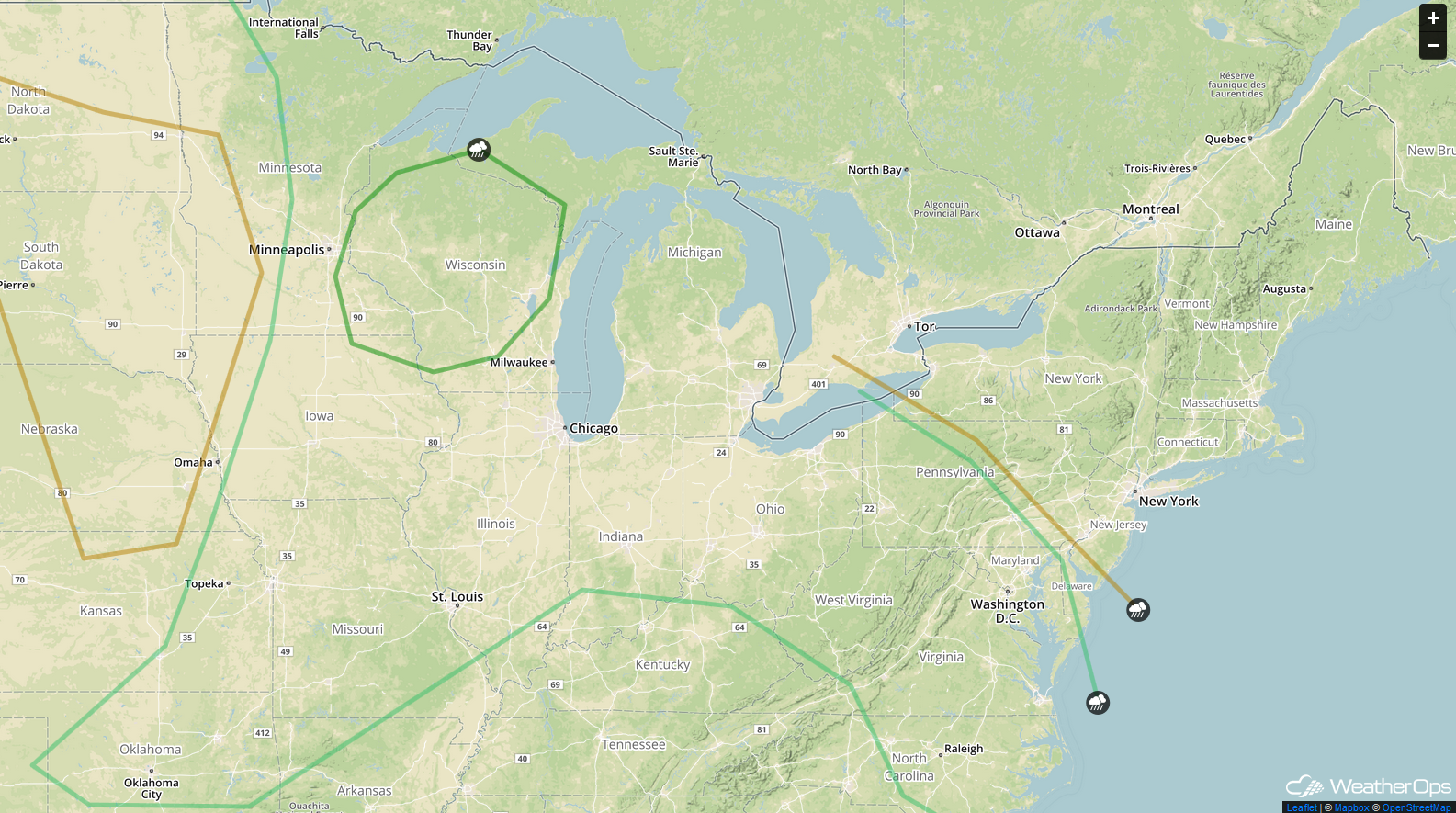 SPC Convective Outlook for Wednesday
Severe Thunderstorms Expected across Minnesota and Northern Iowa on Wednesday
The greatest potential overlap of high instability and shear will exist across Minnesota, western Wisconsin, and northern Iowa. Damaging winds, large hail, and potentially a few tornadoes will be possible during the afternoon and evening. Some uncertainty exists, especially with regards to the tornado threat, given that the event is still a few days away. Heavy rainfall will also lead to the risk of isolated flash flooding.
Major Cities in Region: Madison, WI, Green Bay, WI
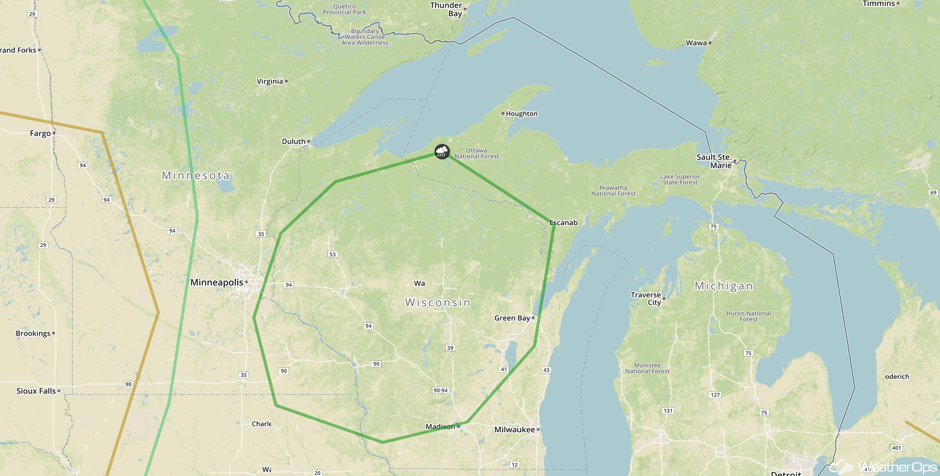 SPC Convective Outlook for Wednesday
Strong to Severe Thunderstorm Risk Wednesday for the Ohio Valley and Mid Atlantic
A nearly stationary frontal zone draped west to east from the southern Great Lakes to the Delmarva Peninsula will act as a converging line for southerly winds and rising dewpoints. Instability will be maximized along and just south of the front. Scattered thunderstorms, a few of which capable of damaging winds and large hail, may develop. The most likely time frame for any organized strong storms is the mid to late afternoon hours.
Major Cities in Region: Cincinnati, OH, Charleston, WV, Pittsburgh, PA, Raleigh, NC, Washington, DC
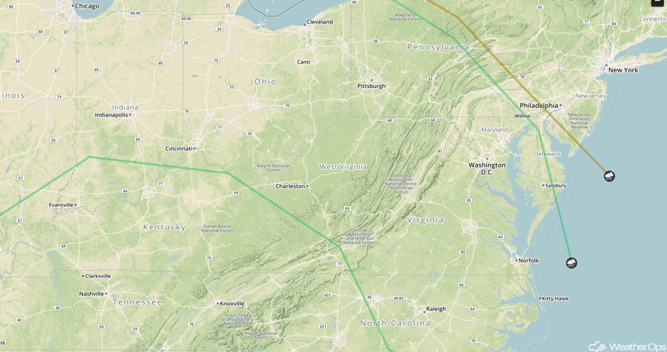 SPC Convective Outlook for Wednesday
A Look Ahead
A cold front from the Great Lakes into the Plains will allow for a risk of thunderstorms across the Central Plains on Thursday. A few thunderstorms may develop Thursday across portions of the Midwest and Ohio Valley. Another risk for thunderstorms will develop Saturday across portions of the Ohio Valley. By Sunday, the thunderstorm risk will shift into the northeast.
This is just a brief look at current weather hazards. We can provide you site-specific weather forecast information for the purpose of protecting your personnel and assets and to assess your weather risk. Try a 7-day demo right away and learn how timely precision weather information can enhance your bottom line.


