


by David Moran, on Jun 11, 2018 10:58:52 AM
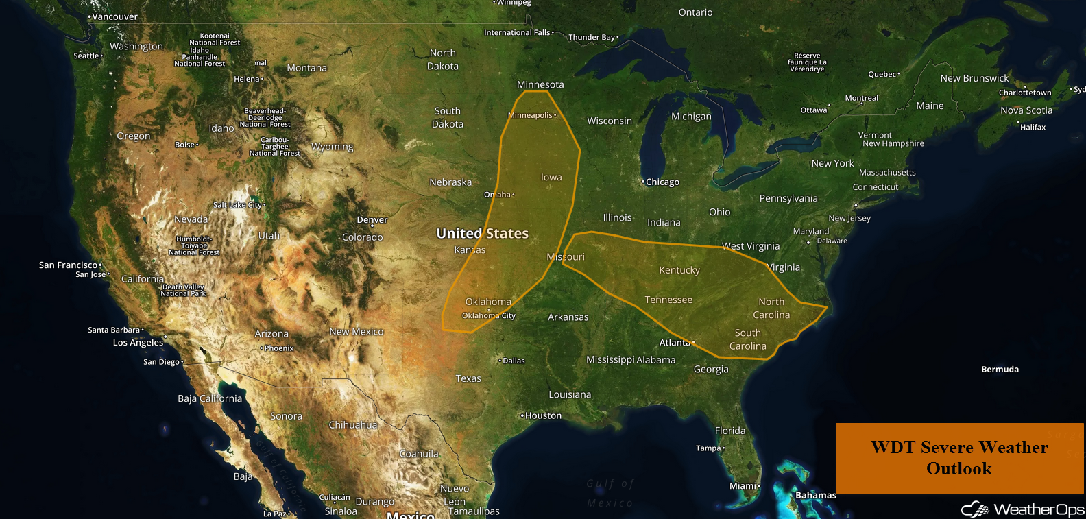
A cold front will be the focus for severe thunderstorm development from the Midwest into the Southern Plains on Monday. This activity will have the potential to produce excessive rainfall across the Upper Midwest. Thunderstorms are forecast to develop from the Ohio Valley through the Carolinas ahead of a cold front. Some thunderstorms across the Ohio Valley may allow for a risk of flooding.
- Thunderstorms from the Midwest into the Southern Plains on Monday
- Excessive Rainfall Monday across the Upper Midwest
- Potential for Thunderstorms from the Ohio Valley into the Carolinas on Monday
- Risk for Excessive Rainfall Monday across the Ohio Valley
- Thunderstorm Potential for the Central and Southern Plains on Tuesday
- Excessive Rainfall Tuesday for the Ohio Valley
- Thunderstorms from the Central Plains into the Midwest on Wednesday
 US Hazards

Thunderstorms from the Midwest into the Southern Plains on Monday
Strong to severe thunderstorms are expected to develop from the Midwest into Oklahoma on Monday. A cold front will move eastward throughout the day and will be the focus for the development of thunderstorms during the mid to late afternoon. Large hail and damaging winds will be the primary hazards with any storm that develops. By the evening, thunderstorms will evolve into a complex and move southward or southeastward overnight with damaging winds becoming the primary hazard.
Major Cities in Region: Oklahoma City, OK, Topeka, KS, Kansas City, MO, Omaha, NE, Des Moines, IA
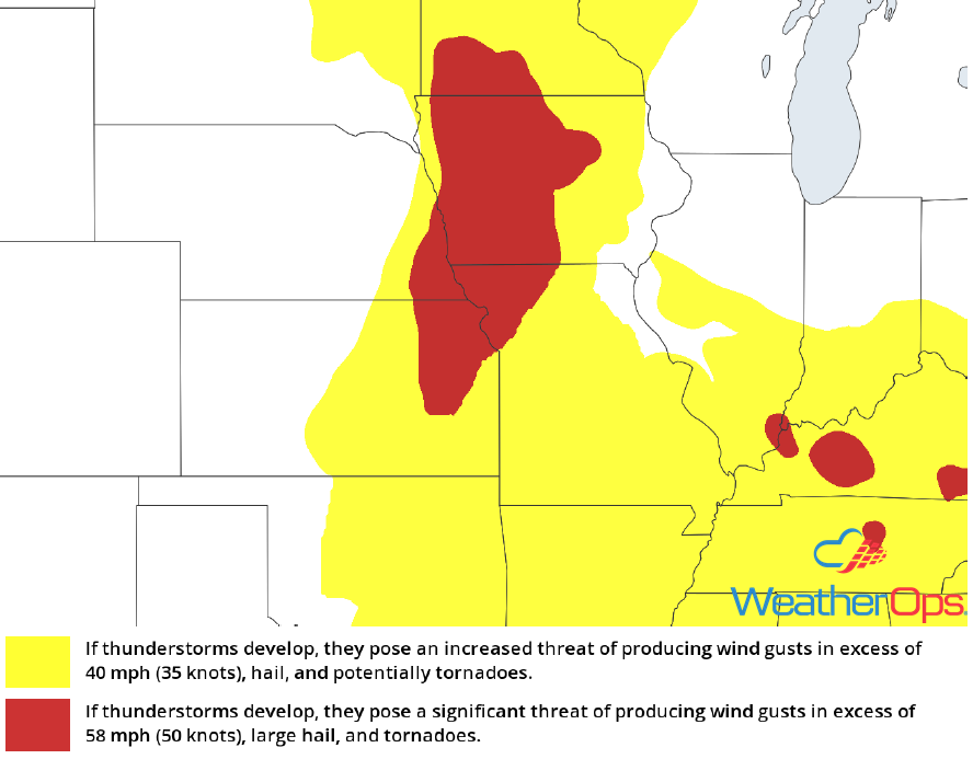 Thunderstorm Risk for Monday
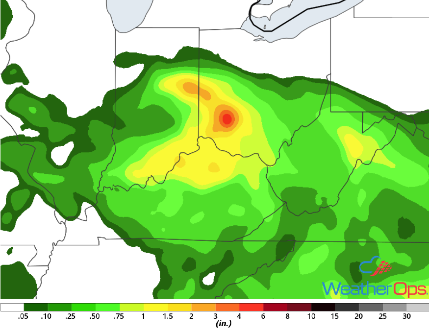
Excessive Rainfall Monday across the Upper Midwest
In addition to the thunderstorm potential described above, there will be the potential for excessive rainfall across the Upper Midwest. Rainfall totals will range 1-2 inches in the heavier storms, leading to a risk of flash flooding.
Major Cities in Region: Bemidji, MN, Minneapolis, MN
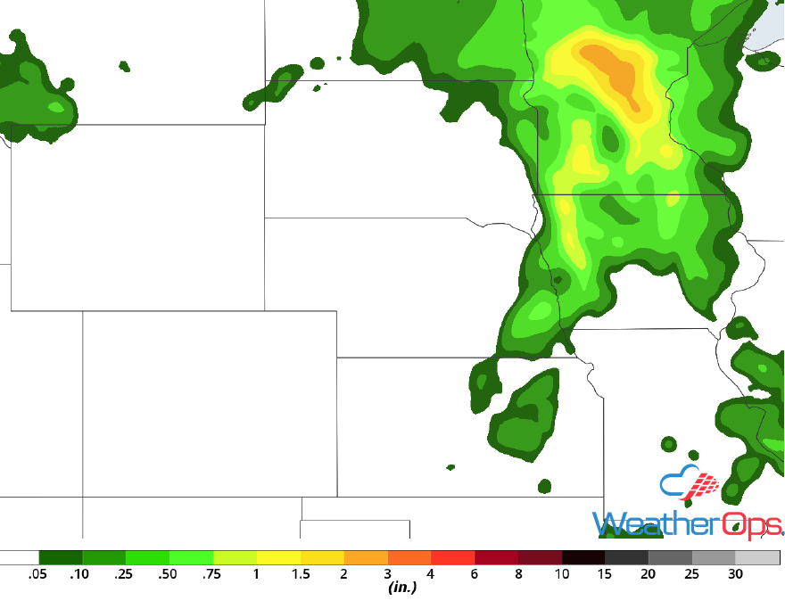 Rainfall Accumulation for Monday
Potential for Thunderstorms from the Ohio Valley into the Carolinas on Monday
There is a marginal threat for strong to severe thunderstorms across portions of the Ohio Valley into the Mid Atlantic on Monday. A moist and unstable air mass will be located to the south of a cold front that will be moving eastward. Thunderstorms may develop ahead of the front across Ohio through the Appalachians and into the Carolinas. Strong to damaging winds and hail will be the primary hazards with these storms.
Major Cities in Region: Evansville, IN, Nashville, TN, Louisville, KY, Atlanta, GA, Knoxville, TN, Charleston, WV, Columbia, SC, Raleigh, NC, Myrtle Beach, SC
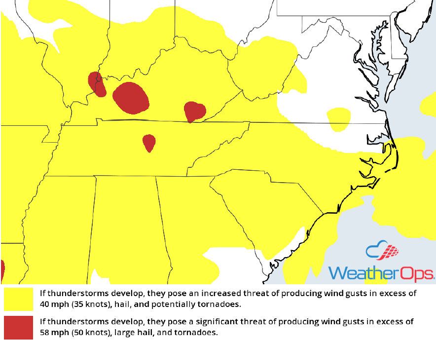 Thunderstorm Risk for Monday
Risk for Excessive Rainfall Monday across the Ohio Valley
Periods of heavy rain are forecast through the day and evening as multiple rounds of precipitation are expected. Some thunderstorms may be heavy, especially during the afternoon and evening. Due to rain from previous days, there will be a risk for runoff and flash flooding. Rainfall amounts of 1-2 inches and locally heavier amounts are expected with stronger storms and areas that receive multiple rounds of rain.
Major Cities in Region: Louisville, KY, Cincinnati, OH, Columbus, OH
 Rainfall Accumulation for Monday
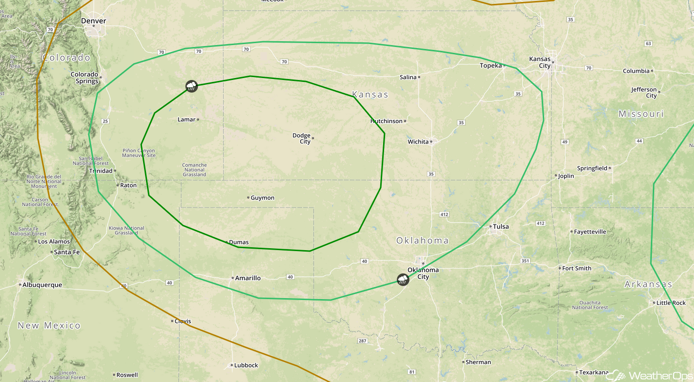
Thunderstorm Potential for the Central and Southern Plains on Tuesday
Thunderstorms will impact portions of the Central and Southern Plains on Tuesday as a weak area of low pressure develops over the southern High Plains. Upslope flow and a stalled frontal boundary may allow for the development of thunderstorms across portions of Colorado, Kansas, and Oklahoma. Thunderstorms will likely develop across the High Plains during the evening. Hail and strong to damaging winds will be the primary hazards with these storms.
Major Cities in Region: Amarillo, TX, Guymon, OK, Dodge City, KS, Oklahoma City, OK, Wichita, KS, Topeka, KS
 SPC Convective Outlook for Tuesday
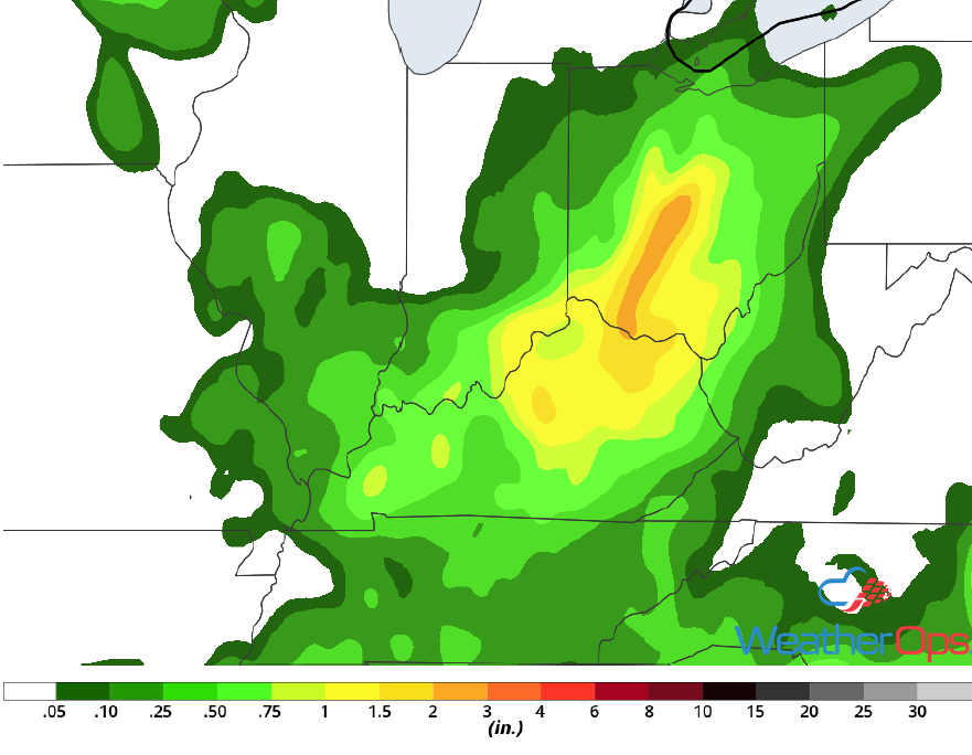
Excessive Rainfall Tuesday for the Ohio Valley
The risk for flash flooding will continue across the Ohio Valley on Tuesday as a front remains stalled across the region. Shower and thunderstorm activity will likely increase in coverage and intensity during the afternoon and evening. An additional 1-2 inches of rain with locally higher amounts in excess of 3 inches are forecast, leading to a risk for flash flooding.
Major Cities in Region: Cincinnati, OH, Columbus, OH
 Rainfall Accumulation for Tuesday
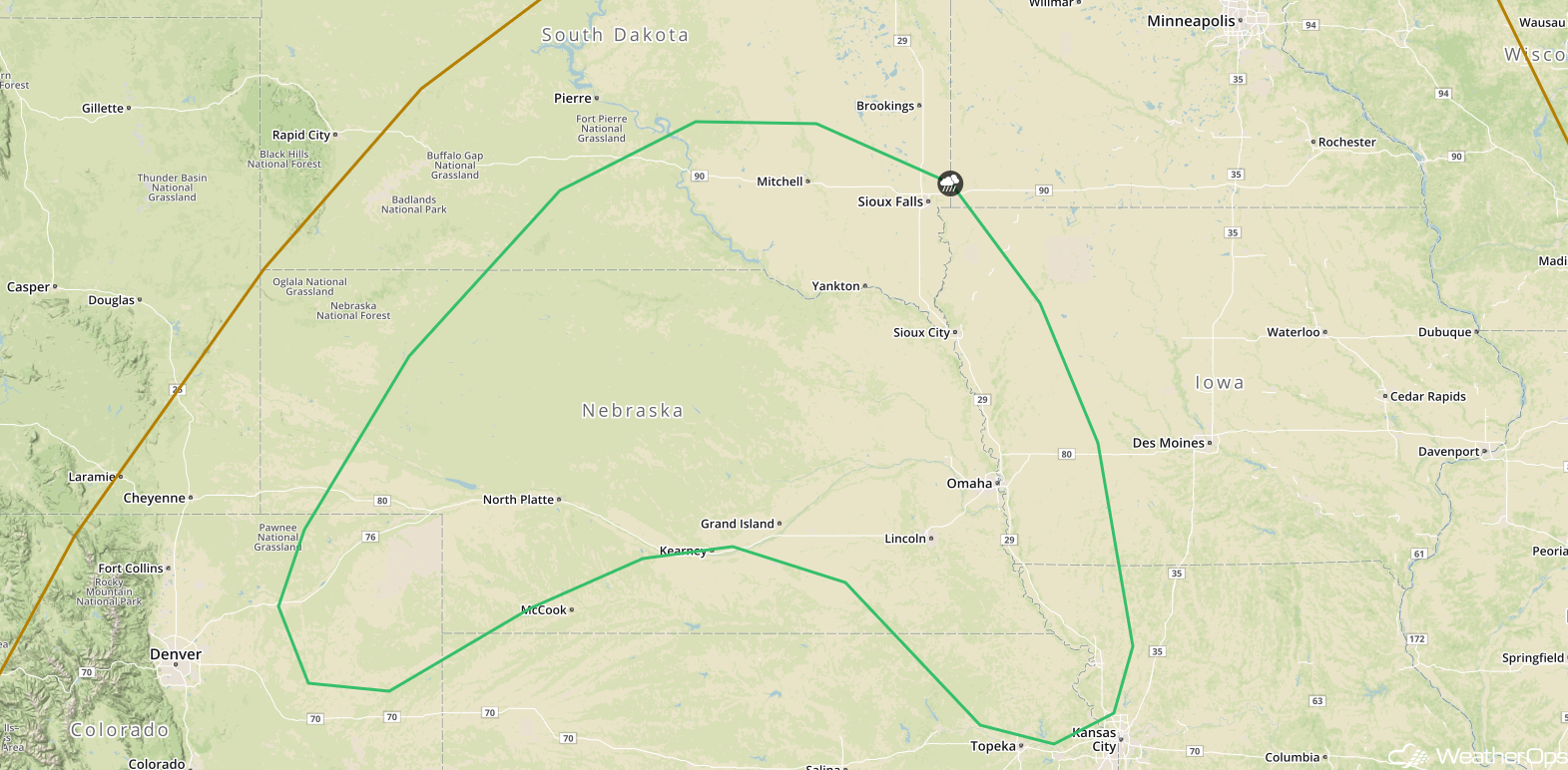
Thunderstorms from the Central Plains into the Midwest on Wednesday
The potential for thunderstorms will continue across portions of the Plains and Midwest on Wednesday as an area of low pressure develops over the Plains. Widely scattered thunderstorms will develop over portions of Iowa, Kansas, and Nebraska during the afternoon hours. Large hail and damaging winds will be the primary hazards with these storms.
Major Cities in Region: North Platte, NE, Omaha, NE, Sioux City, IA, Sioux Falls, SD
 SPC Convective Outlook for Wednesday
A Look Ahead
An area of low pressure will form across the Northern High Plains on Thursday, allowing for the development of thunderstorms across portions of the Northern and Central Plains. By Friday, this activity will move into the Upper Midwest and Great Lakes. Looking ahead to the weekend, another round of thunderstorms may develop across the Upper Midwest and Northern Plains on Saturday. This activity may continue into Sunday.
This is just a brief look at current weather hazards. We can provide you site-specific weather forecast information for the purpose of protecting your personnel and assets and to assess your weather risk. Try a 7-day demo right away and learn how timely precision weather information can enhance your bottom line.
