


by David Moran, on Jul 9, 2018 11:21:46 AM
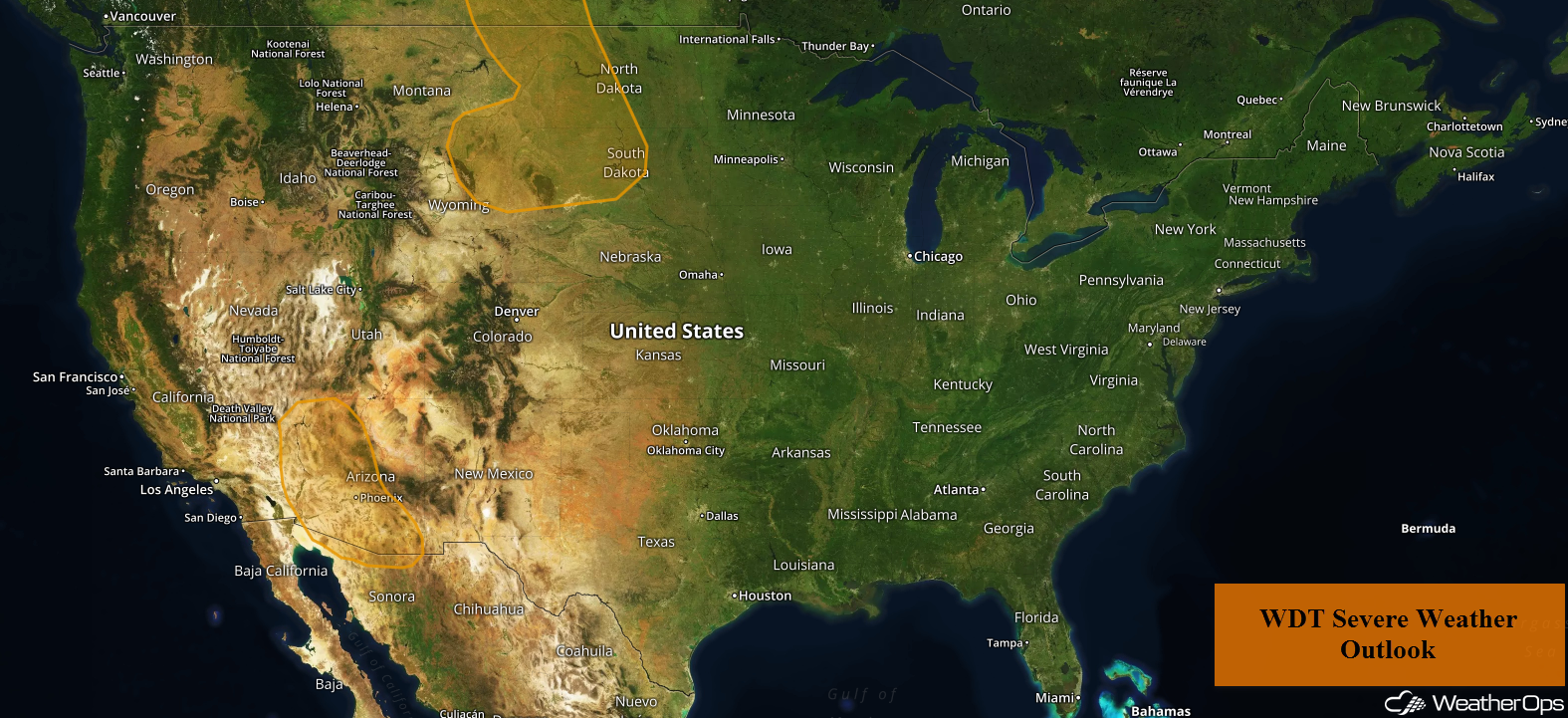
A cold front and an upper level trough moving across the Northern High Plains may allow for the development of thunderstorms on Monday. Thunderstorms are expected across southeastern California and southern Arizona as instability builds during the afternoon. Some of these thunderstorms may produce excessive rainfall.
- Thunderstorms for the Northern High Plains on Monday
- Risk for Thunderstorms Monday across Southeastern California and Southern Arizona
- Excessive Rainfall for Southern Arizona on Monday
- Thunderstorm Potential Tuesday for the Northern Rockies
- Thunderstorms for the Ohio Valley on Tuesday
- Risk for Thunderstorms Wednesday for the Northern Plains
- Excessive Rainfall for Minnesota on Wednesday
- Risk for Excessive Rainfall Wednesday across the Central Rockies
- Tropical Update
 US Hazards

Thunderstorms for the Northern High Plains on Monday
Relatively moist air, combined with daytime heating, will allow instability to increase through the afternoon. Forcing provided by a frontal boundary and a weak upper level system should be sufficient for the development of isolated showers and thunderstorms, some of which could be severe. Damaging winds will be the primary hazard, but some large hail cannot be ruled out.
Major Cities in Region: Rapid City, SD
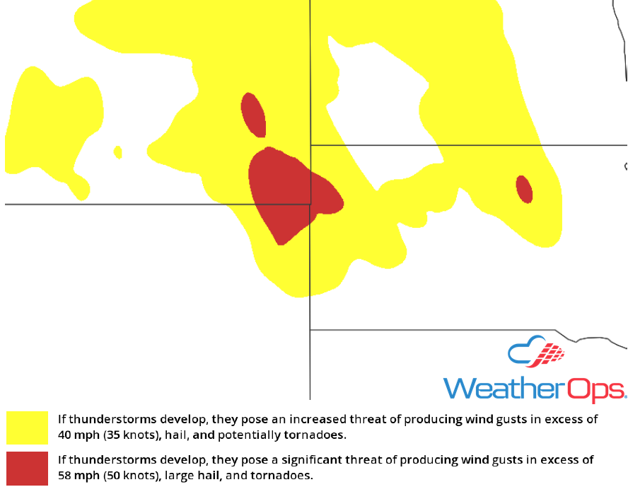 Thunderstorm Risk for Monday
Risk for Thunderstorms Monday across Southeastern California and Southern Arizona
Showers and thunderstorms are expected to develop during the afternoon as instability builds due to daytime heating. Damaging winds will be the primary hazard with these storms. This activity should decrease as the sun sets.
Major Cities in Region: Phoenix, AZ, Tucson, AZ
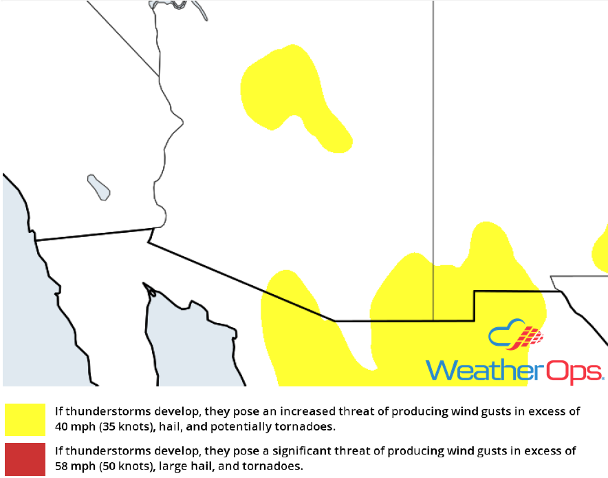 Thunderstorm Risk for Monday
Excessive Rainfall for Southern Arizona on Monday
In addition to the thunderstorms described above, there will be a risk for heavy to excessive rainfall. Rainfall accumulations will range 1-3 inches with locally higher amounts in excess of 4 inches.
Major Cities in Region: Phoenix, AZ, Tucson, AZ
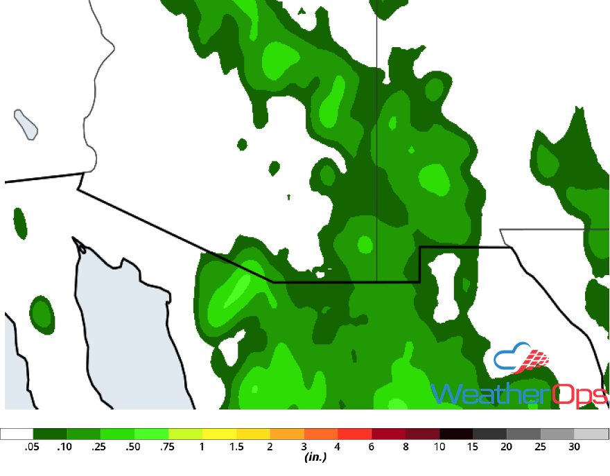 Rainfall Accumulation for Monday
Thunderstorm Potential Tuesday for the Northern Rockies
A strong upper level low will move into south central Canada on Tuesday with a surface low developing in the lee of the Rockies. Southerly winds east of the low will bring warm moist air northward. As the low moves northeastward, a cold front will move through the region. Showers and thunderstorms will develop along and ahead of the cold front with damaging winds and large hail the primary hazards. Isolated tornadoes cannot be ruled out.
Major Cities in Region: Glasgow, MT, Glendive, MT
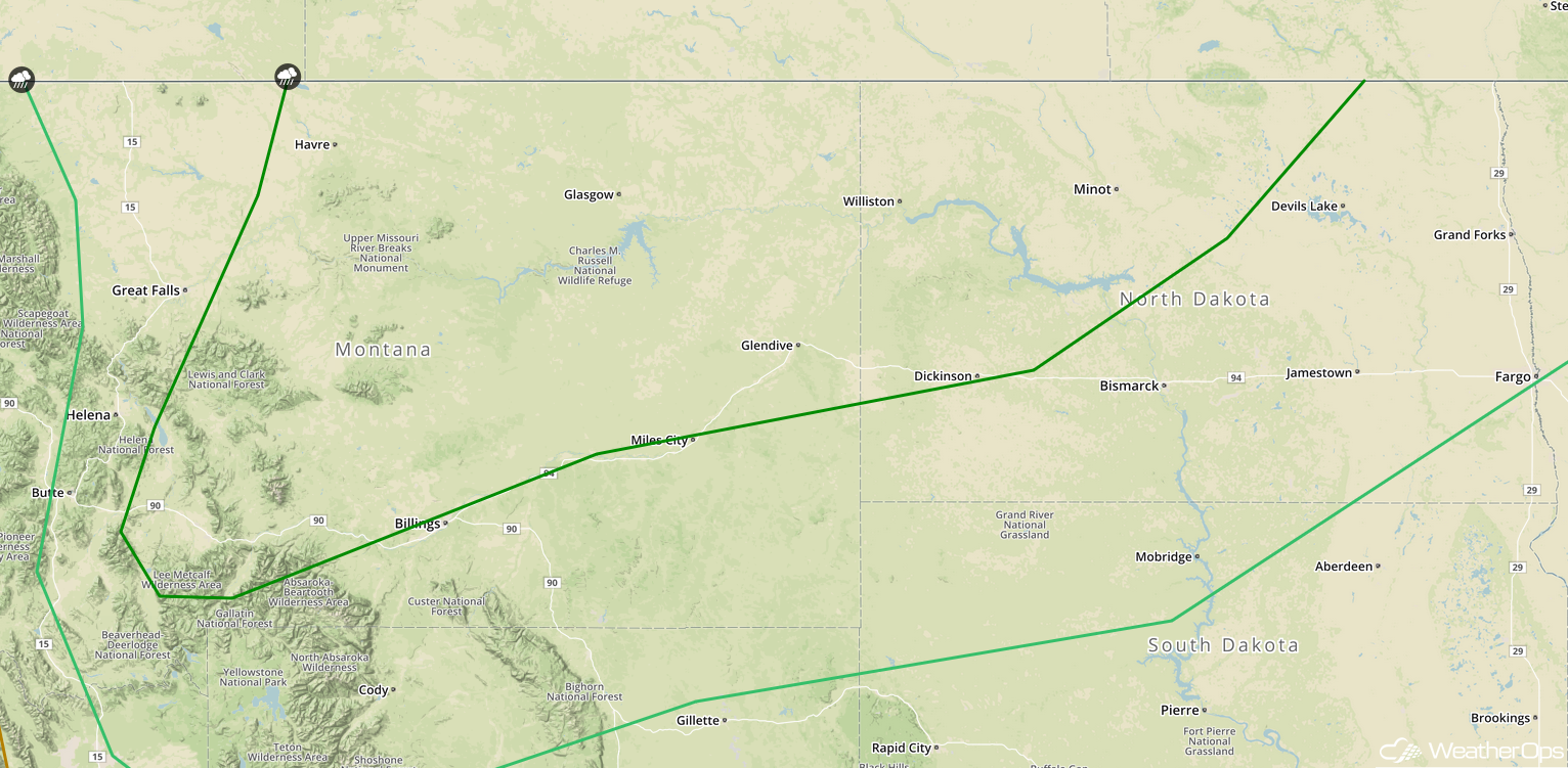 SPC Convective Outlook for Tuesday
Thunderstorms for the Ohio Valley on Tuesday
Thunderstorms are expected to develop across the Ohio Valley on Tuesday as an upper level low moves eastward. At the surface, a cold front will move across the region, allowing for the development of isolated strong to severe thunderstorms. Activity will likely develop during the afternoon with damaging winds the primary hazard. Storms should dissipate during the evening with the loss of daytime heating.
Major Cities in Region: Cincinnati, OH, Columbus, OH, Pittsburgh, PA
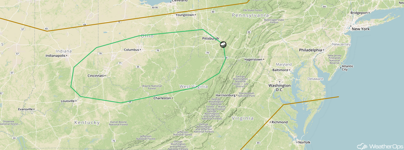 SPC Convective Outlook for Tuesday
Risk for Thunderstorms Wednesday for the Northern Plains
The cold front and upper level trough described above will support the development of thunderstorms across the Northern Plains on Wednesday. Large hail and damaging winds will be the primary hazards initially. However, as thunderstorms begin to cluster, damaging winds will become the main threat. These storms will move eastward and could continue into the overnight hours.
Major Cities in Region: Minot, ND, Bismarck, ND, Grand Forks, ND, Fargo, ND
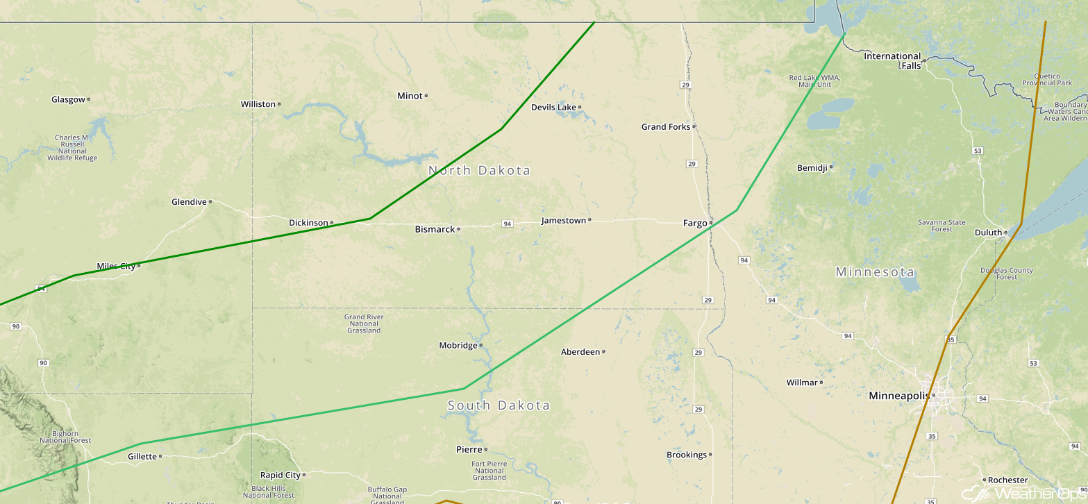 SPC Convective Outlook for Wednesday
Excessive Rainfall for Minnesota on Wednesday
Thunderstorms may develop across portions of Minnesota on Wednesday ahead of a cold front. These thunderstorms could produce rainfall amounts of 1-3 inches with locally higher amounts in excess of 4 inches. This may result in localized flash flooding.
Major Cities in Region: Bemidji, MN, International Falls, MN
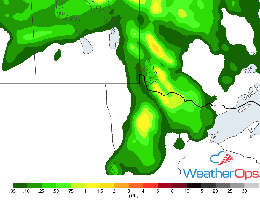 Rainfall Accumulation for Wednesday
Risk for Excessive Rainfall Wednesday across the Central Rockies
A weak upper level low moving over the region will allow for the development of showers and thunderstorms across the Central Rockies on Wednesday. Any thunderstorms that develop will be slow movers, allowing a risk for excessive rainfall. If thunderstorms form clusters, 1-2 inches of rainfall, with locally higher amounts in excess of 3 inches, are expected.
Major Cities in Region: Grand Junction, CO, Durango, CO
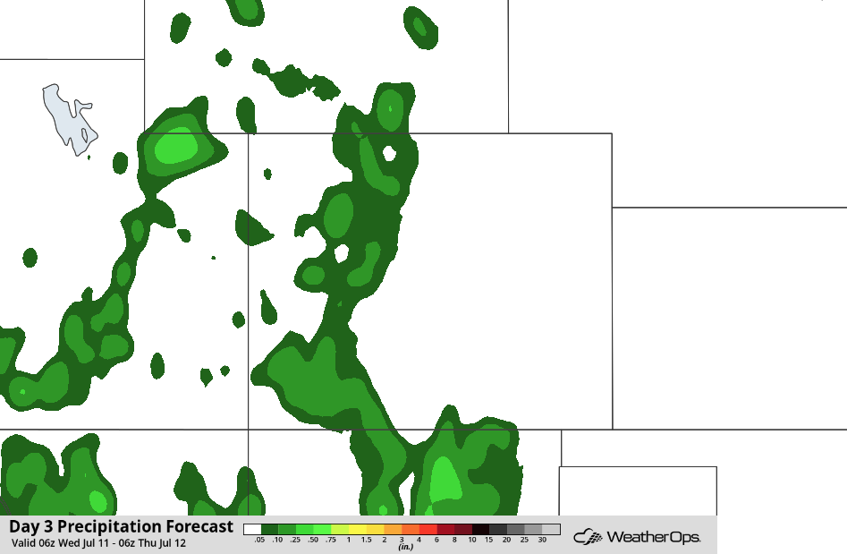 Rainfall Accumulation for Wednesday
Tropical Update
Tropical Storm Chris (green oval) is currently located 215 miles south-southeast of Cape Hatteras, North Carolina with winds at 60 mph. It is presently stationary with little motion expected over the next day or so. Chris is expected to become a hurricane on Tuesday and move northeastward Wednesday into Thursday.
The remnants of Beryl (red oval) are continuing to produce heavy rainfall and strong winds across the northeastern Caribbean and the northern Leeward Islands. This disturbance is expected to move west-northwestward over the next day or so, passing over the Virgin Islands and Puerto Rico today, and Hispaniola tonight. Conditions will be unfavorable for redevelopment over the next day or two, but conditions could become more favorable for redevelopment later this week.
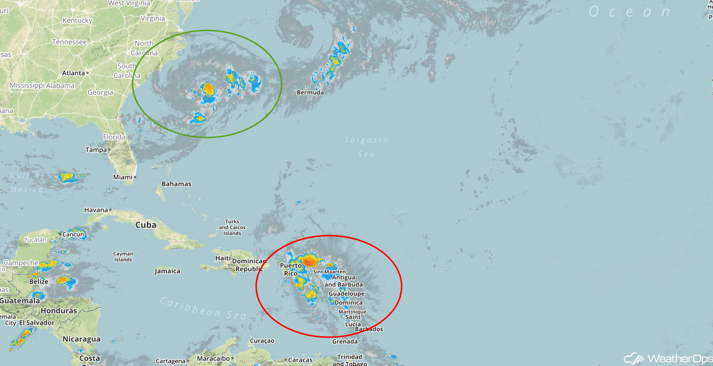 Enhanced Infrared Satellite
A Look Ahead
Thunderstorms may develop across the Northern Plains and Upper Midwest on Thursday as a cold front moves eastward. An additional round of thunderstorms may develop across the Northern Plains on Friday. By Saturday, the potential for showers and thunderstorms will move into the Ohio Valley and Southeast. Another cold front may allow for the formation of thunderstorms across the Upper Midwest and Great Lakes on Sunday.
This is just a brief look at current weather hazards. We can provide you site-specific weather forecast information for the purpose of protecting your personnel and assets and to assess your weather risk. Try a 7-day demo right away and learn how timely precision weather information can enhance your bottom line.
