National Weather Summary for Monday, July 24, 2017
by David Moran, on Jul 24, 2017 11:10:25 AM
Thunderstorms may develop Monday across the Northern Plains as an area of low pressure moves across Canada and the associated fronts move across the Northern Plains. A strong upper level disturbance will aid in the development of thunderstorms across the Mid Atlantic. Across the Tennessee Valley, thunderstorms are forecast as an area of low pressure and cold front moves across the region. Excessive rainfall will continue across the Southwest and Intermountain West as monsoon moisture continues to overspread the region. Scattered showers and thunderstorms may bring a risk of excessive rainfall to portions of the Gulf Coast.
- Risk for Thunderstorms across Portions of the Northern Plains on Monday
- Thunderstorm Potential Monday for the Mid Atlantic and Northeast
- Thunderstorms for the Tennessee Valley on Monday
- Excessive Rainfall Continues Monday for the Southwest and Intermountain West
- Risk for Excessive Rainfall along the Gulf Coast Monday
- Strong to Severe Thunderstorms Tuesday across the Northern Plains and Upper Midwest
- Excessive Rainfall Continues for the Intermountain West on Tuesday
- Potential for Thunderstorms across the Midwest on Wednesday
- Excessive Rainfall Risk on Wednesday across Colorado and New Mexico
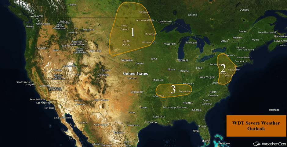 US Hazards
Risk for Thunderstorms across Portions of the Northern Plains on Monday
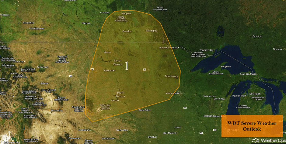
Isolated thunderstorms are expected to develop across the Northern Plains this afternoon and evening as a warm front and area of low pressure moves across southern Canada. While significant impacts are not anticipated, some of the stronger storms could post a low threat of severe winds and hail before dark.
Major Cities in Region: Minot, ND, Bismarck, ND, Pierre, SD
 Region 1
Thunderstorm Potential Monday for the Mid Atlantic and Northeast
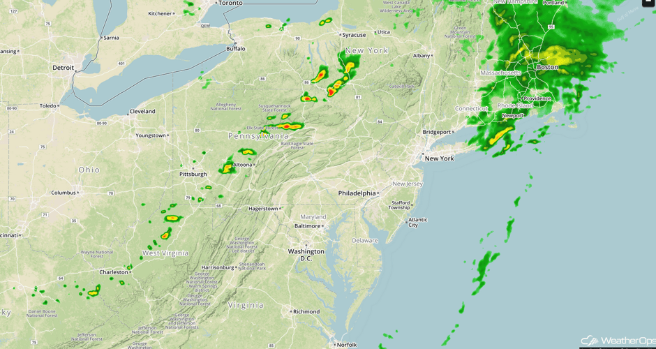
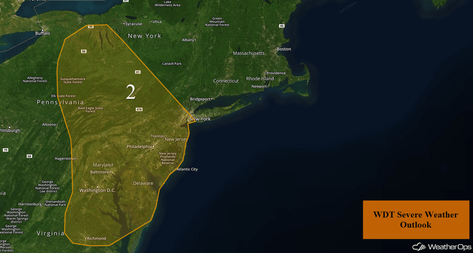
Thunderstorms may develop across portions of the Mid Atlantic and Northeast as an upper level trough pushes through the region. The bulk of the current morning shower and thunderstorm activity will gradually clear out by midday with redevelopment or reintensification of activity expected later this afternoon. A few storms could pose a low threat of marginally severe wind and hail before dark.
Update 2:30pm EDT: Showers and thunderstorms developing across New York and Pennsylvania ahead of a front.
 Radar 2:30pm EDT
Major Cities in Region: Washington, DC, Baltimore, MD, Philadelphia, PA, New York, NY
 Region 2
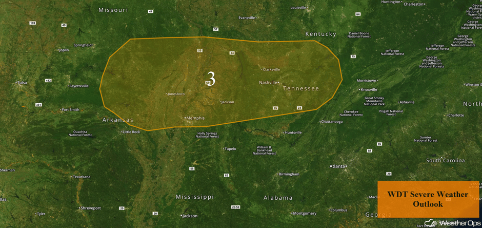
Thunderstorms for the Tennessee Valley on Monday
A weak area of low pressure is forecast to advance toward the Tennessee Valley during the afternoon and evening hours on Monday. This should result in at least widely scattered showers and thunderstorms. While significant impacts are not expected, a few of the stronger storms may pose a low risk for marginally severe wind.
Major Cities in Region: Memphis, TN, Nashville, TN
 Region 3
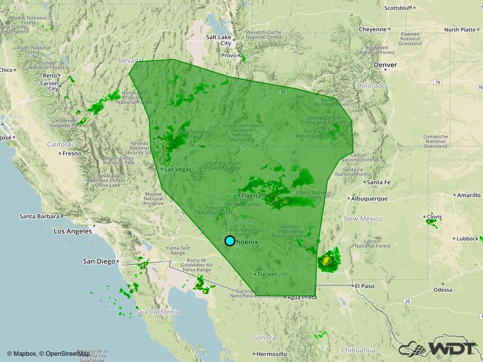
Excessive Rainfall Continues Monday for the Southwest and Intermountain West
As monsoon moisture overspreads much of the Southwest US northward to the Intermountain West, scattered showers and thunderstorms will develop once again today across the region. While not all areas will receive rain, rainfall amounts will range from 0.25-1 inch, with locally higher amounts in excess of 1.50 inches.
Major Cities in Region: Las Vegas, NV, Flagstaff, AZ, Phoenix, AZ, Tucson, AZ
 Excessive Rainfall Risk for Monday
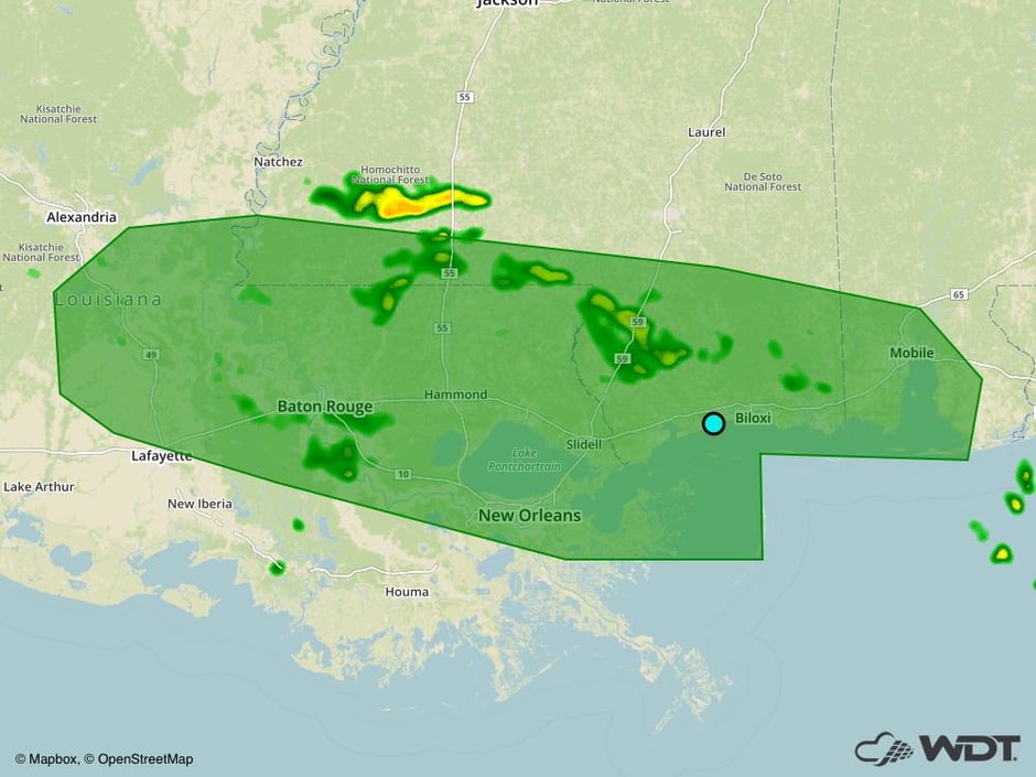
Risk for Excessive Rainfall along the Gulf Coast Monday
Scattered showers and thunderstorms are already occurring across portions of the Gulf Coast this morning and will likely continue to develop over the region through the late afternoon or early evening hours. Some areas of excessive rainfall may occur with general amounts of 0.75-1.50 inches and locally higher amounts in excess of 2 inches.
Major Cities in Region: Baton Rouge, LA, New Orleans, LA, Biloxi, MS, Mobile, AL
 Excessive Rainfall Risk Outline for Monday
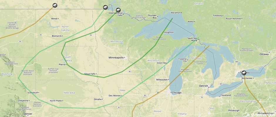
Strong to Severe Thunderstorms Tuesday across the Northern Plains and Upper Midwest
As an area of low pressure intensifies over Canada, instability will build ahead of a cold front. Scattered thunderstorms are anticipated across much of the Northern Plains by the afternoon hours, eventually congealing into one or more organized complexes by the late evening as they approach the Upper Midwest. Large hail, damaging winds, and tornadoes will all be possible with these storms. Later in the evening, thunderstorms will transition to a damaging wind threat. In addition, there will be a risk for excessive rainfall. Rainfall amounts could range from 1-2 inches with locally higher amounts in excess of 2.50 inches.
Major Cities in Region: North Platte, NE, Minot, ND, Bismarck, ND, Pierre, SD, Sioux Falls, SD, Omaha, NE, Des Moines, IA, Minneapolis, MN, Green Bay, WI
 SPC Convective Outlook for Tuesday
Excessive Rainfall Continues for the Intermountain West on Tuesday
As monsoonal moisture shifts slightly northward, scattered showers and perhaps a few thunderstorms are anticipated across the Intermountain West. For areas that receive precipitation, there will be a risk for excessive rainfall. General amounts of 0.25-0.75 with locally higher amounts in excess of an inch are expected.
Major Cities in Region: Elko, NV, Grand Junction, CO
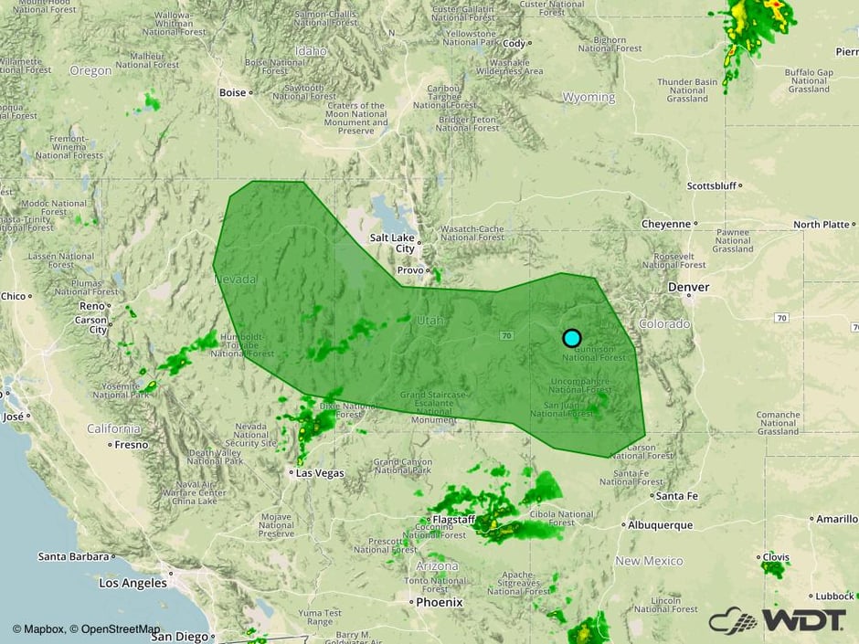 Excessive Rainfall Risk Outline for Tuesday
Potential for Thunderstorms across the Midwest on Wednesday
The risk for thunderstorms will shift slightly southeastward and impact much of the Midwest on Wednesday. As a cold front slowly moves southeastward into the region, increasing instability ahead of the front will likely lead to scattered thunderstorm development. Thunderstorms, potentially strong or severe, may be ongoing early in the day across the Upper Midwest, with additional development likely throughout the day across the remainder of the region. Large hail and damaging winds will be the primary hazards with these storms, though an isolated tornado or two cannot be ruled out with the stronger storms. In addition to the severe threat, excessive rainfall may occur, generally centered around the Iowa/Illinois border.
Major Cities in Region: Sioux Falls, SD, Omaha, NE, Des Moines, IA, Minneapolis, MN, St. Louis, MO, Green Bay, WI, Milwaukee, WI, Chicago, IL, Indianapolis, IN, Cincinnati, OH
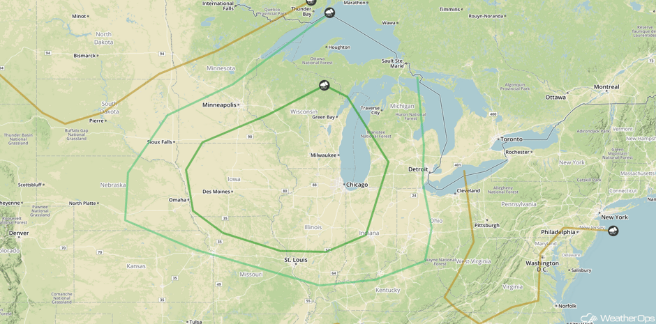 SPC Convective Outlook for Wednesday
Excessive Rainfall Risk on Wednesday across Colorado and New Mexico
As deep moisture spreads over the region and a cold front moves in from the north, shower and thunderstorm development can be expected across portions of Colorado and New Mexico on Wednesday. There may be a risk for excessive rainfall across the region. Rainfall amounts could range 0.50-1.00 inch with locally higher amounts in excess of 1.25 inches.
Major Cities in Region: Aspen, CO, Santa Fe. NM
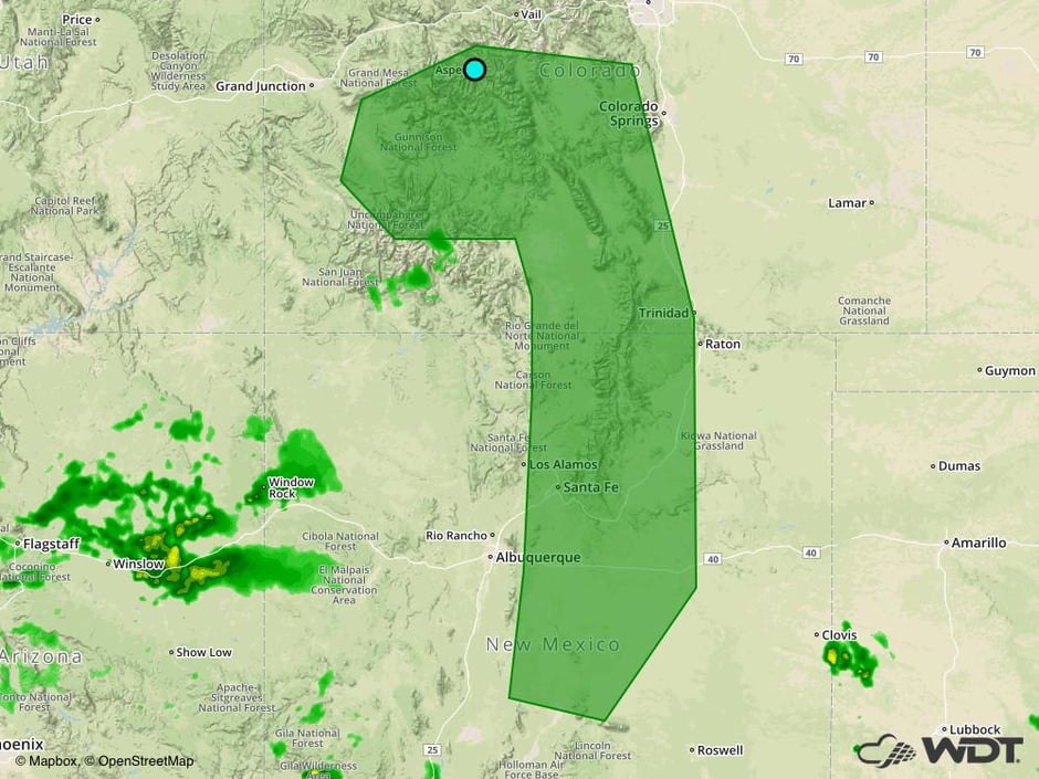 SPC Convective Outlook for Wednesday
A Look Ahead
Showers and thunderstorms may develop across the Ohio Valley and Northeast as a cold front and area of low pressure move through the region. Gusty winds and hail will be the primary hazards. Storms will continue across the Tennessee Valley on Friday as the cold front continues to move southeastward. Gusty winds will be the primary hazard with these storms.
This is just a brief look at current weather hazards. We can provide you site-specific weather forecast information for the purpose of protecting your personnel and assets and to assess your weather risk. Try a 7-day demo right away and learn how timely precision weather information can enhance your bottom line.


