


by David Moran, on Jul 23, 2018 11:08:51 AM
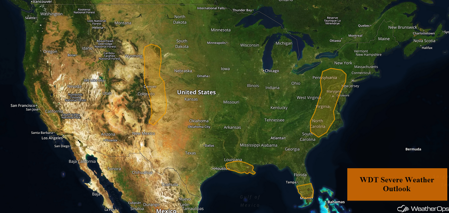
Daytime heating will allow for the development of strong to severe thunderstorms across portions of central and southern Florida on Monday. A stalled front will be the focus for the development of thunderstorms across southeastern Louisiana. Thunderstorms may develop across the Mid Atlantic as an upper level trough moves across the region. These storms, as well as additional activity on Tuesday, will bring a risk for excessive rainfall across portions of Northeast and Mid Atlantic through Tuesday. Upslope flow may allow for the development of thunderstorms across eastern Colorado and New Mexico. This activity will pose the potential for excessive rainfall.
- Risk for Thunderstorms Monday across Central and Southern Florida
- Thunderstorms for Southeastern Louisiana on Monday
- Potential for Thunderstorms Monday across the Mid Atlantic
- Excessive Rainfall for the Mid Atlantic and Northeast Through Tuesday
- Thunderstorm Potential Monday for Eastern Colorado and New Mexico
- Risk for Excessive Rainfall for Colorado and New Mexico Through Tuesday
- Thunderstorms Tuesday for the Northern Plains
- Potential for Thunderstorms across the Central Plains and Upper Midwest on Wednesday
US Hazards
Risk for Thunderstorms Monday across Central and Southern Florida
Strong to severe thunderstorms may develop across central and southern Florida this afternoon. Damaging winds will be the primary hazards with these storms. Activity should dissipate during the late afternoon and early evening.
Major Cities in Region: Sarasota, FL, Naples, FL, Fort Myers, FL, Miami, FL, Palm Beach, FL
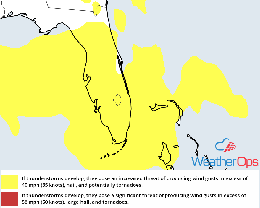
Thunderstorm Risk for Monday
Thunderstorms for Southeastern Louisiana on Monday
Thunderstorms are forecast to develop across southeastern Louisiana on Monday along a stalled front. While upper level support is somewhat weak, instability will increase due to daytime heating and increased moisture. Clusters of strong to severe thunderstorms are expected to develop during the afternoon. Strong winds will be the primary hazard, but there will be a risk for hail and an isolated tornado.
Major Cities in Region: Baton Rouge, LA, New Orleans, LA
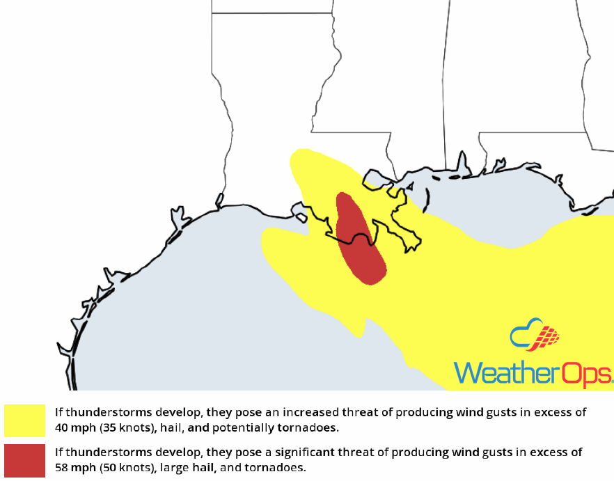
Thunderstorm Risk for Monday
Potential for Thunderstorms Monday across the Mid Atlantic
An upper level trough, combined with a weak area of low pressure, will provide forcing for the development of thunderstorms. Daytime heating, combined with plentiful moisture, will allow instability to build through the afternoon. As clusters of thunderstorms develop during the afternoon and evening, strong winds and hail will be the primary hazards. There will also be the potential for frequent lightning and heavy rainfall.
Major Cities in Region: Raleigh, NC, Richmond, VA, Washington, DC, Baltimore, MD
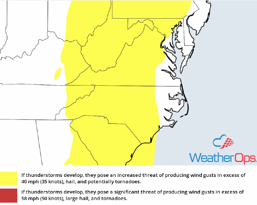
Thunderstorm Risk for Monday
Excessive Rainfall for the Mid Atlantic and Northeast through Tuesday
In addition to the thunderstorm risk described above, there will be a potential for excessive rainfall through Tuesday. Two day rainfall amounts will range 2-4 inches with locally higher amounts in excess of 5 inches. Given this rainfall and previous rainfall over the past few days, there will be a risk for flooding and flash flooding.
Major Cities in Region: Richmond, VA, Washington, DC, Baltimore, MD, New York City, NY
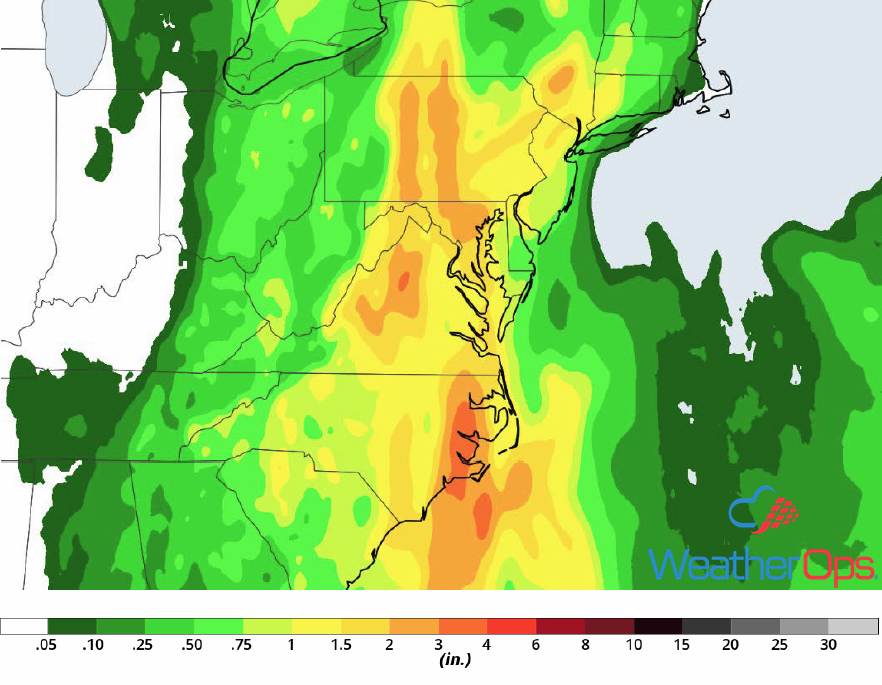
Rainfall Accumulation through Tuesday
Thunderstorm Potential Monday for Eastern Colorado and New Mexico
Overall atmospheric forcing will be somewhat limited, but easterly flow is expected across Colorado on Monday. This will provide lift along the Front Range for the development of thunderstorms across eastern Colorado and northeastern New Mexico. As thunderstorms develop, they will develop into clusters with strong winds and large hail the primary hazards.
Major Cities in Region: Albuquerque. NM, Denver, CO, Colorado Springs, CO, Pueblo, CO, Lamar, CO
Thunderstorm Risk for Monday
Risk for Excessive Rainfall for Colorado and New Mexico Through Tuesday
The thunderstorms described above will have a potential to produce heavy to excessive rainfall across Eastern Colorado and New Mexico. Rainfall totals through Tuesday will range 1-2 inches with locally higher amounts in excess of 3 inches. This will allow for a potential for flooding and flash flooding.
Major Cities in Region: Albuquerque, NM, Denver, CO, Colorado Springs, CO, Pueblo, CO, Lamar, CO
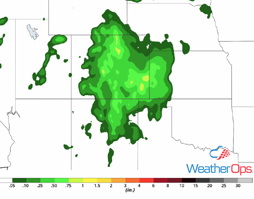
Rainfall Accumulation through Tuesday
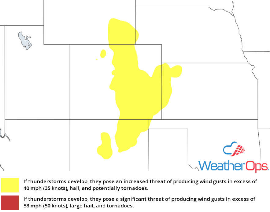
Thunderstorms Tuesday for the Northern Plains
An area of low pressure is forecast to develop over eastern Montana with strong to severe thunderstorms developing to the southeast. There is some uncertainty due to morning storms. However, instability should be sufficient for the development of showers and thunderstorms during the afternoon and evening. Strong winds and large hail will be the primary hazards with these storms.
Major Cities in Region: Bismarck, ND, Pierre, SD, North Platte, NE Aberdeen, SD
SPC Convective Outlook for Tuesday
Potential for Thunderstorms across the Central Plains and Upper Midwest on Wednesday
The area of low pressure described above will continue to move northeastward into Canada on Wednesday. The trailing cold front will progress to the east and southeast with moderate instability developing ahead of the front during the afternoon and evening. As a result, strong to severe thunderstorms are forecast along and ahead of the cold front. Some storms may organize into linear segments with strong winds and large hail the primary hazards.
Major Cities in Region: North Platte, NE, Lincoln, NE, Sioux Falls, SD, Sioux City, IA, Omaha, NE, Des Moines, IA, Minneapolis, MN, Wausau, WI
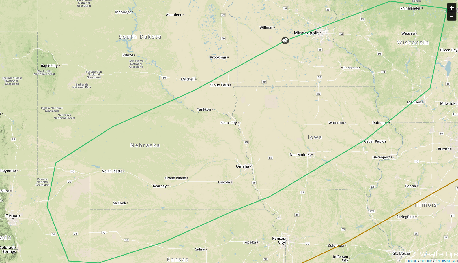
SPC Convective Outlook for Wednesday
A Look Ahead
Upslope flow may increase across the Central High Plains on Thursday, allowing for the development of showers and thunderstorms. Across the Northeast, showers and thunderstorms may develop ahead of a cold front on Friday. By the weekend, thunderstorms are forecast across the Central Plains. on Saturday. This activity will move into the Missouri and Mid-Mississippi River Valleys on Sunday.
