by David Moran, on Jul 18, 2016 11:15:51 AM
Scattered thunderstorms will be possible for portions of the Upper Ohio Valley and Northeast on Monday ahead of an approaching cold front. Heavy rainfall will be possible across portions of Iowa as multiple rounds of storms move through the state. Across the High Plains, thunderstorms capable of damaging winds will be possible. On Tuesday, the remnants of a front stalled across the Midwest will be the focus for the development of thunderstorms. Thunderstorms and heavy rain will be possible for portions of the Mid Atlantic as a cold front moves through the region. Across the Northern Plains and Great Lakes, thunderstorms will be possible on Wednesday as an upper level trough develops.

US Hazards
Region 1
A warm, unstable air mass will continue to spread across portions of Region 1 on Monday in advance of a southward moving cold front. Thunderstorms are ongoing across some of the region, and this activity will likely continue into the afternoon hours while increasing in coverage and intensity. Conditions are favorable for storms to become strong or severe, with damaging winds the primary threat. There will be a lower risk of large hail or tornadoes with some of the more organized activity. Storms will begin to diminish near and after sunset with the loss of daytime heating.
Major Cities in Region: Augusta, ME, Boston, MA, New York, NY, Philadelphia, PA, Washington, DC, Cincinnati, OH

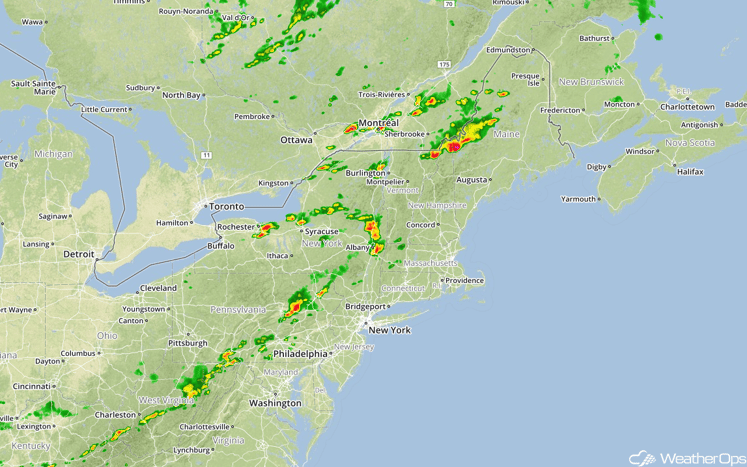
Region 1
Update 1:17pm EDT: Thunderstorms producing hail and damaging winds are developing across portions of New York and Pennsylvania. Hail as large as 1.75 inches has been reported in Central Pennsylvania.
Radar 1:17pm EDT
Excessive Rainfall Possible Monday for Iowa
Two rounds of storms may develop across Iowa on Monday; the first will be ongoing convection from the preceding night that will continue through the morning hours. Another round may develop in the afternoon and evening along the western end of a cold front. Total rainfall amounts from these areas will be around 1-2 inches, with locally higher amounts in excess of 3 inches possible in areas that receive repeated rounds of storms.
Major Cities in Region: Davenport, IA

SPC Convective Outlook for Monday
Strong to Severe Thunderstorms for High Plains on Monday
Upslope flow into the mountains may cause another round of strong to severe thunderstorms across the High Plains. Hail and damaging winds will be the most likely threats across the region.
Major Cities in Region: Bismarck, ND, Pierre, SD

SPC Convective Outlook for Monday
Strong to Severe Thunderstorms Continuing Across Midwest on Tuesday
Some thunderstorm activity may continue on Tuesday along the remnants of a stalled front. Moisture and instability are expected to be sufficient for the development of severe thunderstorms. Large hail and damaging winds will be possible with any storms that develop.
Major Cities in Region: Minneapolis, MN, Des Moines, IA, St. Louis, MO, Lexington, KY

SPC Convective Outlook for Tuesday
Strong to Severe Thunderstorms Possible for Mid Atlantic on Tuesday
A few thunderstorms will have the potential to become severe as a cold front moves through the region. Plentiful moisture and instability will allow for a few storms capable of hail and strong to damaging winds. In addition, rainfall amounts of 1-2 inches can be expected with locally heavier amounts in excess of 3 inches possible.
Major Cities in Region: Raleigh, NC, Richmond, VA

SPC Convective Outlook on Tuesday
Strong to Severe Thunderstorms Possible Wednesday for the Northern Plains and Great Lakes
A developing area of low pressure east of the Rockies and high pressure over the eastern US will enhance southerly flow across the region. Moist air from the south will move in and isolated strong to severe thunderstorms may form in the afternoon and evening hours. The primary threats will be large hail and damaging winds.
Major Cities in Region: Bismarck, ND, Minneapolis, MN, Chicago, IL, Milwaukee, WI

SPC Convective Outlook for Wednesday
This is just a brief look at current weather hazards. We can provide you site-specific forecast information for the purpose of protecting your personnel and assets. Try a 7-day demo right away and learn how timely precision weather information can enhance your bottomline.