National Weather Summary for Monday, July 17, 2017
by David Moran, on Jul 17, 2017 10:16:02 AM
Thunderstorms are forecast to develop across the Great Plains and Upper Midwest on Monday as an area of low pressure moves across the region. An area of low pressure and associated fronts will move into the Northeast Monday, allowing for the risk for thunderstorms. Strong to severe thunderstorms may develop over southern Arizona as instability increases during the afternoon.
- Thunderstorms for the Northern Plains and Upper Midwest on Monday
- Risk for Thunderstorms Monday across the Northeast
- Continued Thunderstorms across the Northern Plains and Upper Midwest on Tuesday
- Thunderstorm Potential Wednesday for the Northern Plains and Upper Midwest
- Tropical Update
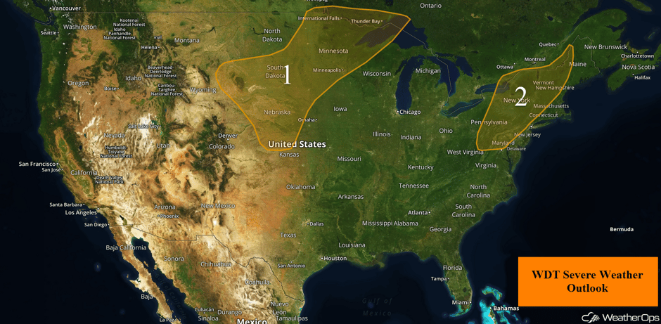 US Hazards
Thunderstorms for the Northern Plains and Upper Midwest on Monday
A warm front has made it as far north as southern Manitoba while moisture continues to surge northward. Warm, moist, and unstable air to the east of a slow moving cold front over Montana and western North Dakota will create a favorable environment for at least isolated severe thunderstorm development. The greatest threat for storms capable of producing large hail and damaging winds will be from far eastern South Dakota into central and northern Minnesota. While non-severe storms have already developed, the more robust threat will be during the mid to late afternoon. Storms may diminish in intensity while becoming increasingly isolated after sunset. With that said, there is a threat for a few strong storms across the eastern half of the region through the overnight hours.
Major Cities in Region: North Platte, NE, Pierre, SD, Sioux Falls, SD, Minneapolis, MN, International Falls, MN
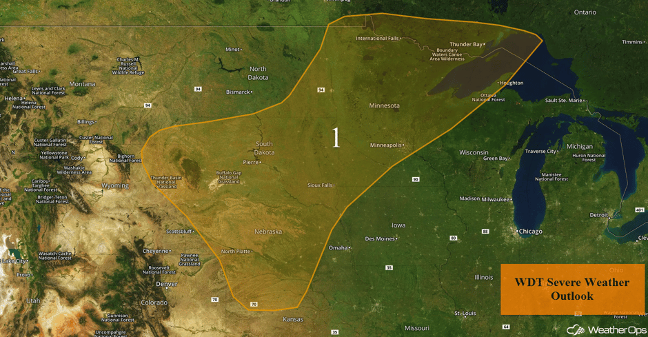 Region 1
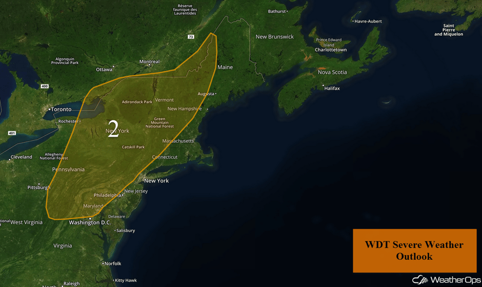
Risk for Thunderstorms Monday across the Northeast
A nearly stationary front extends from northern Maine southwestward into western New York and Pennsylvania. A slow moving upper level disturbance is also moving across the region. Moderate instability and wind shear east of the front will support a slight risk for the development of isolated severe storms across portions of the Northeast. A few non-severe thunderstorms are currently ongoing across central and northern New York. Storm coverage and intensity is expected to increase by the late morning and afternoon. The greatest threat for isolated severe storms with the potential for hail and damaging winds will span from northeast Pennsylvania northward into portions of Vermont and New Hampshire. Storm intensity and coverage should diminish significantly after sunset.
Update 12:47pm EDT: Thunderstorms capable of hail and damaging winds moving through eastern New York.
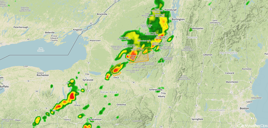 Radar 12:47pm EDT
Update 1:21pm EDT: Severe Thunderstorm Watch for portions of New York, Pennsylvania, and Vermont until 8pm EDT.
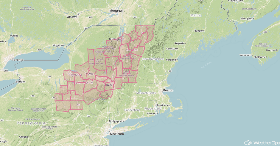 Severe Thunderstorm Watch
Major Cities in Region: Syracuse, NY, Baltimore, MD, Albany, NY, Burlington, VT
 Region 2
Continued Thunderstorms on Tuesday across the Northern Plains and Upper Midwest
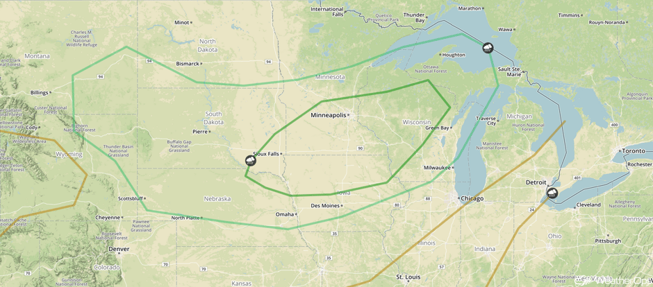
An upper level trough and associated surface low will bring the potential for strong to severe thunderstorms across the Northern Plains and Upper Midwest on Tuesday. Ongoing showers and thunderstorms will likely be present during the morning hours. Strong southerly winds ahead of a cold front will pull warm, moist air northward. This coupled with daytime heating will allow instability to build, leading to the development of isolated thunderstorms during the afternoon. Into the evening and overnight, one or more thunderstorm complexes may develop. Strong to severe winds and hail will be the primary hazards, but an isolated tornado or two cannot be ruled out.
In addition, excessive rainfall may develop across the region. Rainfall amounts of 0.50-1.50 inches are expected with locally higher amounts.
Major Cities in Region: North Platte, NE, Pierre, SD, Sioux Falls, SD, Omaha, NE, Des Moines, IA, Minneapolis, MN, Green Bay, WI
 SPC Convective Outlook for Tuesday
Thunderstorm Potential for the Northern Plains and Upper Midwest Wednesday
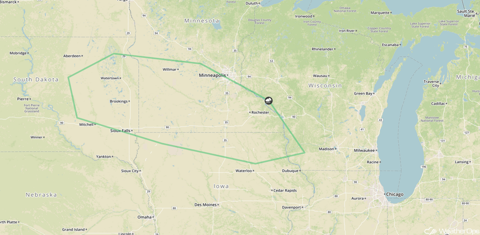
A weak area of low pressure will allow for a risk for severe thunderstorms on Wednesday. Southeasterly winds will pump warm, moist air into the region, allowing for the development of showers and thunderstorms during the afternoon over portions of east-central South Dakota and spread southeastward into southern Minnesota. While the risk for severe hazards is low, strong to severe wind gusts and hail will be the main threats.
Once again, excessive rainfall will be a concern on Wednesday. Rainfall amounts of 0.50-1.00 inches are expected with locally higher amounts in excess of 1.50 inches.
Major Cities in Region: Sioux Falls, SD, Minneapolis, MN
 SPC Convective Outlook for Wednesday
Tropical Update
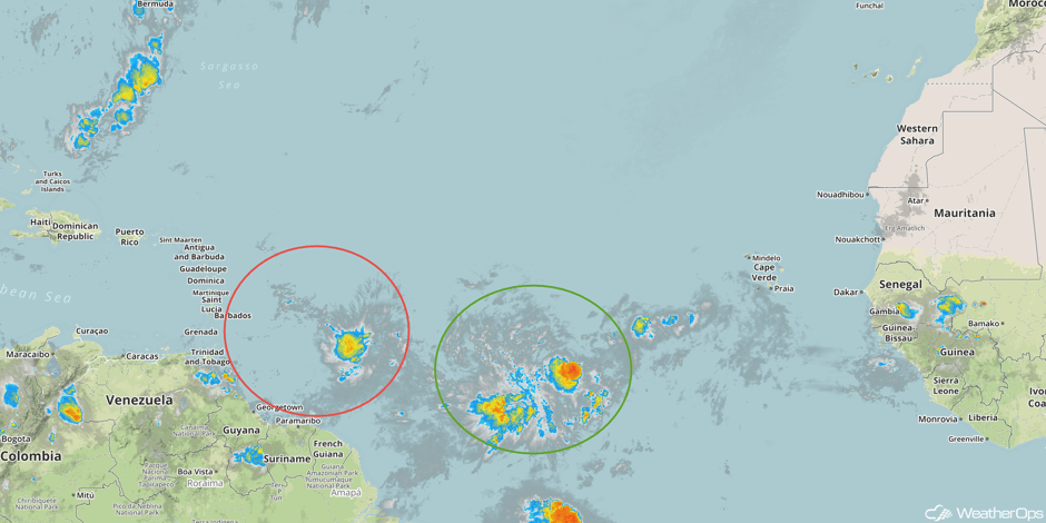
An area of low pressure (red oval) located about 750 miles east of the Windward Islands is moving westward at about 15 mph. The associated shower and thunderstorm activity shows some organization, but no well defined center is present. Some further development is possible before reaching the Lesser Antilles late Tuesday or early Wednesday. After that time, less favorable upper level winds will hinder further development. Regardless of development, this system is forecast to bring locally heavy rainfall and gusty winds to the Lesser Antilles beginning late Tuesday.
Further east, another disturbance (green oval) is located 800 miles west-southwest of the Cabo Verde Islands. Some gradual development is possible over the next few days while it slowly moves west-northwest or northwest.
 Enhanced Infrared Tropical Satellite
A Look Ahead
An area of low pressure, moving from the Northern Rockies into the Upper Midwest on Thursday, may allow for the development of showers and thunderstorms. By Friday, showers and thunderstorms may form across the Central Plains and Upper Midwest as an area of low pressure moves across the Plains. Across the Northeast, thunderstorms may develop along and ahead of a cold front. Showers and thunderstorms will move into the Central Plains, Great Lakes, Ohio Valley, and Northeast ahead of a cold front. The shower and thunderstorm activity will shift into the Midwest, Central Plains, Ohio Valley, and Northeast on Sunday.
This is just a brief look at current weather hazards. We can provide you site-specific weather forecast information for the purpose of protecting your personnel and assets and to assess your weather risk. Try a 7-day demo right away and learn how timely precision weather information can enhance your bottom line.


