National Weather Summary for Monday, January 15, 2018
by David Moran, on Jan 15, 2018 10:55:16 AM
Snow will continue across the Plains, Great Lakes, and Ohio Valley through Monday evening as an area of low pressure moves into the Great Lakes. Wintry precipitation is expected from Texas eastward into Georgia Monday evening through Tuesday behind a cold front.
- Snow Continuing across the Plains, Great Lakes, and Ohio Valley through Monday Evening
- Wintry Precipitation from Texas into the Southeast Monday Evening through Tuesday
- Potential for Snow across Portions of Virginia and North Carolina Tuesday into Wednesday
- Snow Tuesday and Wednesday across Portions of the Northeast
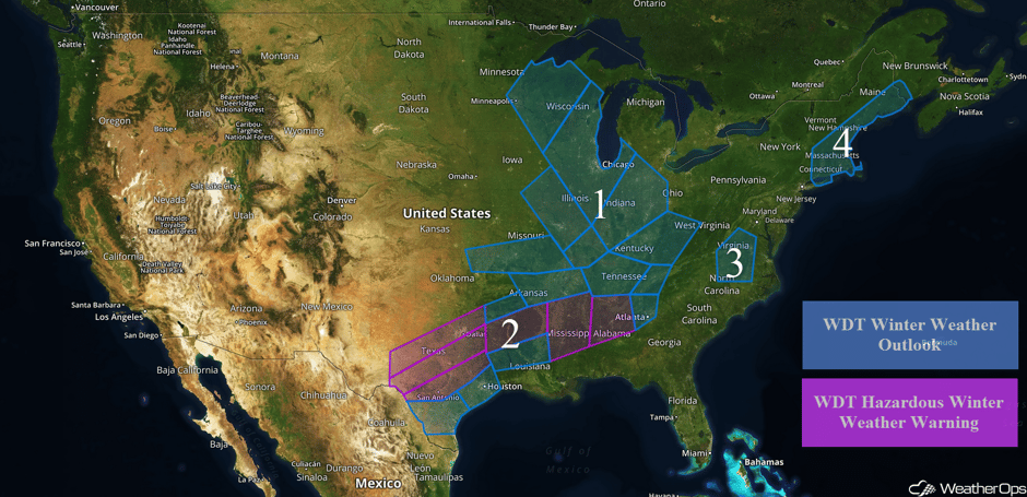 US Hazards
Snow Continuing across the Plains, Great Lakes, and Ohio Valley through Monday Evening
Snow will continue across portions of the Plains and Great Lakes through Monday evening as an area of low pressure moves into the lower Great Lakes. Snowfall totals of 1-2 inches are forecast from Kansas and Missouri into the Ohio Valley. Across portions of Michigan and Wisconsin, snowfall amounts in excess of 4 inches are expected.
Major Cities in Region: Springfield, MO, Minneapolis, MN, St. Louis, MO, Green Bay, WI, Milwaukee, WI, Chicago, IL, Indianapolis, IN, Louisville, KY, Cincinnati, OH, Columbus, OH
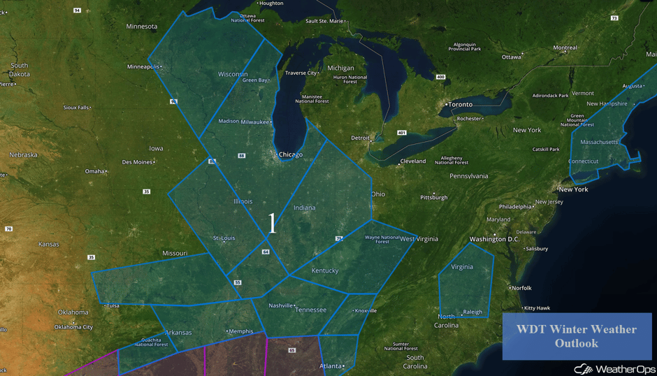 Region 1
Wintry Precipitation from Texas into the Southeast Monday Evening through Tuesday
A wintry mix of precipitation is forecast across portions of Texas Monday night through Tuesday morning as a cold front moves through the region. Snow accumulations around a half an inch and freezing rain accumulations up to a tenth of an inch are expected across portions of western and northern Texas. From southwestern Texas into portions of northeastern Texas, 1-2 inches of snow with locally higher amounts in excess of 3 inches are expected. Across central Texas, freezing rain accumulations between 0.1-0.2 inch with locally higher amounts in excess of a quarter of an inch are expected. For southern Texas, up to a tenth of an inch of ice is forecast. From east Texas into Arkansas, snow accumulations of 1-3 inches with locally higher amounts in excess of 4 inches are expected through early Tuesday evening. Further south into Louisiana, up to an inch of snow is forecast from early Tuesday through Tuesday afternoon. Across portions of Mississippi, Alabama, Tennessee, and West Virginia, snow accumulations will range 1-2 inches with locally higher amounts in excess of 3 inches. Into Georgia, including the Atlanta metropolitan area, a dusting to an inch of snow is expected.
Major Cities in Region: Del Rio, TX, San Antonio, TX, Dallas, TX, Houston, TX, Tyler, TX, Shreveport, LA, Little Rock, AR, Memphis, TN, Jackson, MS, Nashville, TN, Birmingham, AL, Atlanta, GA, Charleston, WV
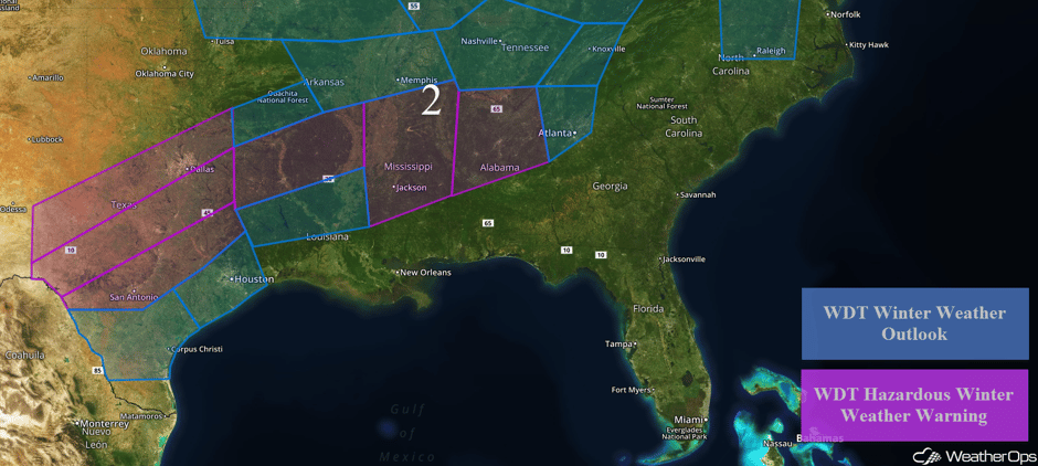 Region 2
Potential for Snow across Portions of Virginia and North Carolina Tuesday into Wednesday
A strong cold front is forecast to move through the region Tuesday evening, bringing a chance for snow. Snow is expected to begin Tuesday evening and continue through Wednesday evening. Accumulations will range 1-2 inches with locally higher amounts in excess of 3 inches.
Major Cities in Region: Lynchburg, VA, Charlottesville, VA, Raleigh, NC, Richmond, VA
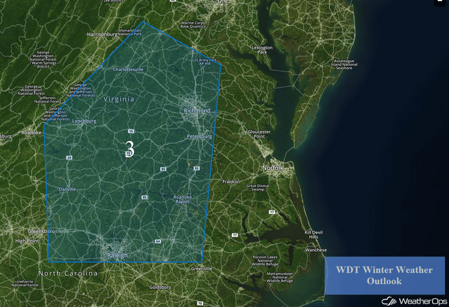 Region 3
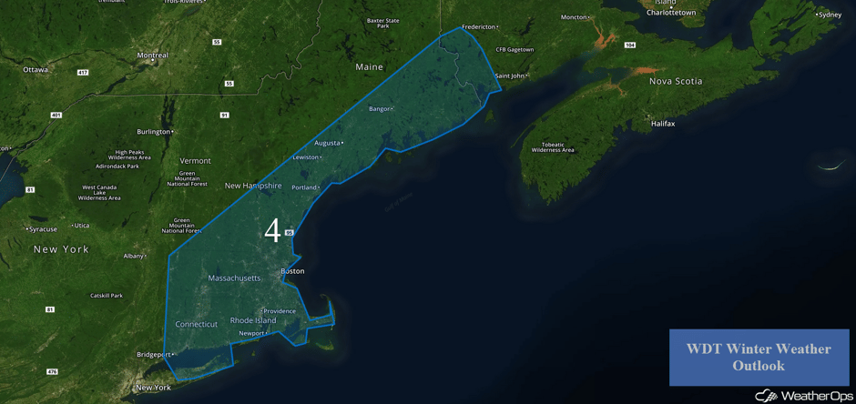
Snow Tuesday and Wednesday across Portions of the Northeast
An area of low pressure and its associated cold front should move through the region on Tuesday, bringing in colder air, as well as the potential for snow. Snow is expected to begin around midday Tuesday and continue through Wednesday evening. Accumulations of 2-5 inches with locally higher amounts in excess of 6 inches are forecast.
Major Cities in Region: Bridgeport, CT, Providence, RI, Boston, MA, Portland, ME, Augusta, ME, Bangor, ME
 Region 4
A Look Ahead
Snow and freezing rain may continue for portions of West Texas through early Thursday. A frontal system moving into the Pacific Northwest is forecast to bring rain to the lower elevations of the Pacific Northwest and snow to the higher elevations on Thursday. On Friday, showers and thunderstorms will move into southeast Texas as an area of low pressure moves northward. Snow will move into the Rockies on Friday as an upper level system moves into the region.
This is just a brief look at current weather hazards. We can provide you site-specific weather forecast information to protect your staff and assets and to assess your weather risk. Try a 7-day demo right away and learn how timely precision weather information can enhance your bottom line.


