


by David Moran, on Feb 19, 2018 11:12:12 AM
Significant winter precipitation is expected from the Rockies northeastward into the Great Lakes through Wednesday as an upper level system moves eastward. Thunderstorms may develop from the Southern Plains into the Missouri Valley on Monday. Dense fog will persist for the Texas and Louisiana coasts through late morning.
- Wintry Precipitation from the Northern Rockies into the Great Lakes through Wednesday
- Thunderstorms Monday from the Southern Plains into the Missouri Valley
- Dense Fog for the Texas and Louisiana Coast through Monday Morning
- Excessive Rainfall Tuesday and Wednesday for the Southern Plains through the Missouri Valley
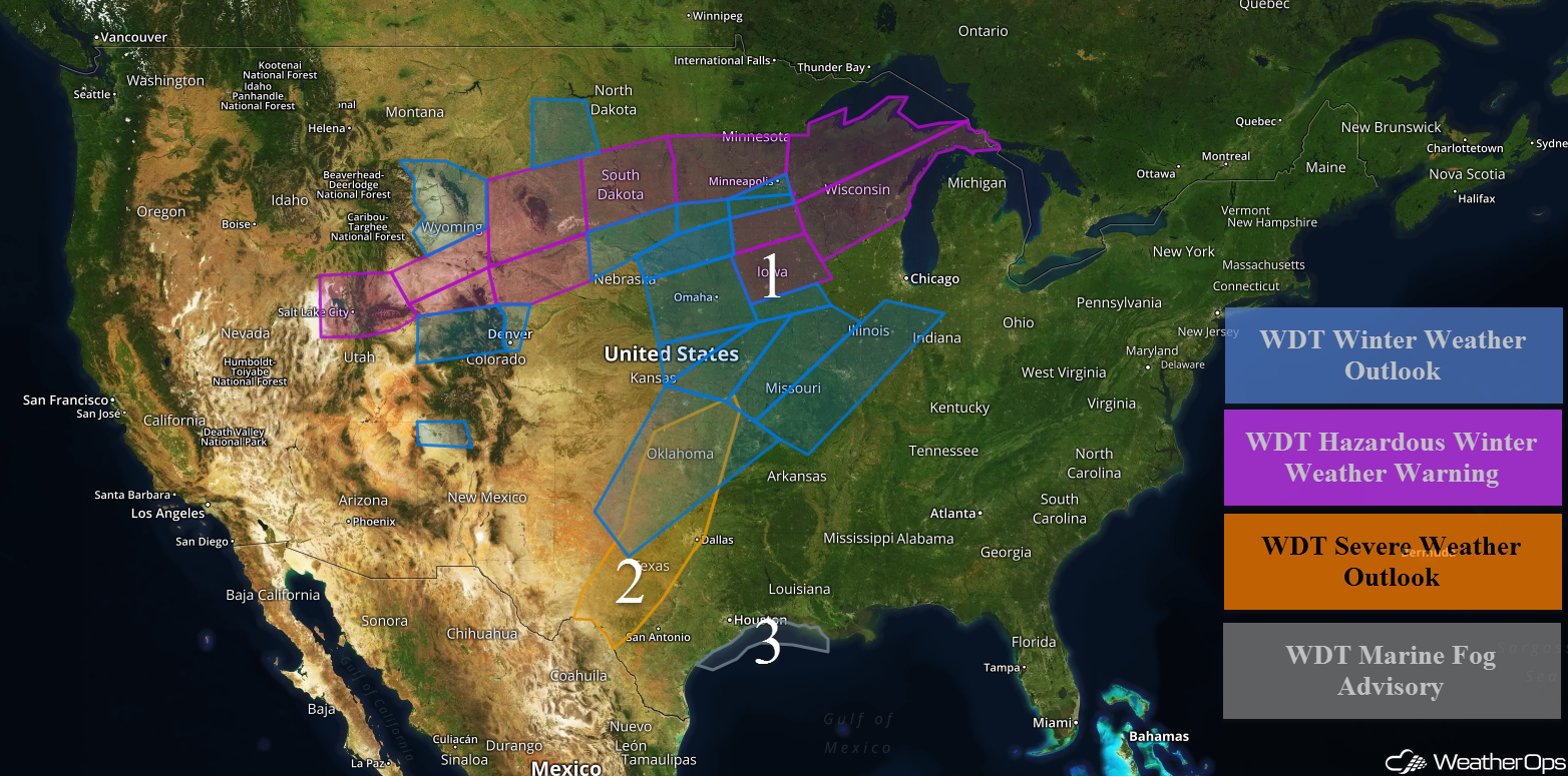 US Hazards

Wintry Precipitation from the Northern Rockies into the Great Lakes through Wednesday
Central Rockies:
Snow will continue for portions of the Rockies through early Tuesday morning as a system moves eastward. For portions of Utah and Colorado, 5-8 inches of snow with locally higher amounts in excess of 10 inches are expected in the lower elevations. In the higher elevations, 8-12 inches with locally higher amounts in excess of 20 inches are expected. Across much of Wyoming, snowfall totals will range 8-12 inches with locally higher amounts in excess of 15 inches. In addition, winds gusting in excess of 25-35 mph will allow for blowing snow and low visibilities. Across southern Wyoming and extreme northern Colorado, 5-7 inches of snow with locally higher amounts in excess of 10 inches are expected. From western Colorado into the Colorado Front Range, snowfall amounts will range 2-4 inches with locally higher amounts in excess of 5 inches. Across northwestern New Mexico, up to 2 inches of snow are expected.
High Plains/Central Plains:
Further east across the High Plains of Wyoming into South Dakota, 7-10 inches of snow with locally higher amounts in excess of a foot are forecast through early Tuesday. In addition, winds gusting to 20-30 mph will allow for wind chills between -10 and -20°F, as well as blowing snow and reduced visibility. Across southeast Wyoming and western Nebraska, snow amounts will range 4-7 inches with locally higher amounts in excess of 9 inches. For southwestern North Dakota and northwestern South Dakota, 3-5 inches of snow with locally higher amounts are forecast. Snow accumulations of 6-10 inches with locally higher amounts in excess of a foot are expected for northern and central South Dakota. Across southern portions of South Dakota and northern Nebraska, snowfall accumulations will range 3-5 inches.
Northern Plains into the Great Lakes:
From eastern South Dakota into Minnesota, 3-6 inches of snow are expected through midday Tuesday. Across southeastern South Dakota into southern Minnesota, snowfall accumulations of 1-4 inches and ice accumulations between 0.10-0.20 inch are forecast with locally higher amounts. Snow accumulations will range 3-5 inches from western Wisconsin into the Upper Peninsula of Michigan through Tuesday afternoon. Ice accumulations will range 0.05-0.20 inch. Further south across central Wisconsin, up to 2 inches of snow with locally higher amounts are forecast. Ice accumulations will range 0.25-0.40 inch.
Central Plains into the Midwest:
Further south across portions of eastern Nebraska and western Iowa through Tuesday morning, snow accumulations will likely remain less than in inch with ice accumulations ranging from 0.05-0.15. In central and eastern Iowa, ice accumulations will range 0.15-0.25 inch with locally higher amounts in excess of 0.30 inch. From eastern Kansas eastward into Missouri and Illinois, ice accumulations will range 0.05-0.15 inch through Wednesday morning. Snow accumulations up to an inch will be possible.
Southern Plains:
Lastly on Wednesday, significant icing may develop from western Texas into southern Kansas, southwestern Missouri, and northwestern Arkansas. While there is some uncertainty, freezing rain appears to be the primary precipitation type, but some snow may develop across northern Oklahoma and southern Kansas.
Major Cities in Region: Salt Lake City, UT, Denver, CO, Cheyenne, WY, Pierre, SD, Oklahoma City, OK, Tulsa, OK, Sioux Falls, SD, Omaha, NE, Kansas City, MO, Des Moines, IA, Minneapolis, MN, St. Louis, MO, Green Bay, WI
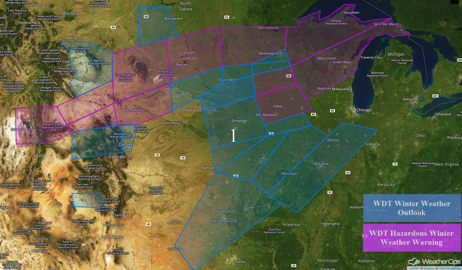 Region 1
Thunderstorms Monday from the Southern Plains into the Missouri Valley
An area of low pressure centered over southeastern Colorado and into the Oklahoma Panhandle will provide the focus for the development of thunderstorms. This system, along with plentiful moisture, will allow for the development of thunderstorms during the afternoon. Large hail will be the primary hazard, but there is a low tornado risk from Oklahoma City to Wichita Falls during the early evening.
Major Cities in Region: Del Rio, TX, Oklahoma City, OK, Dallas/Fort Worth, TX, Tulsa, OK
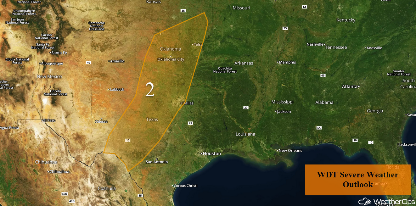 Region 2
Dense Fog for the Texas and Louisiana Coast through Monday Morning
Sea fog will continue along the Texas and Louisiana coasts through Monday morning. Visibilities may drop below a quarter mile at times. Fog should subside during the late morning and midday.
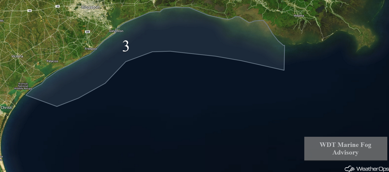 Region 3
Excessive Rainfall Tuesday and Wednesday for the Southern Plains through the Missouri Valley
Scattered showers and thunderstorms will persist from northeast Texas into the Missouri Valley Tuesday into Wednesday. Two day rainfall amounts of 3-6 inches with isolated higher amounts in excess of 8 inches are expected. The highest totals will extend from eastern Texas into the bootheel of Missouri. Flooding and flash flooding will be a concern in these areas.
Major Cities in Region: San Antonio, TX, Dallas, TX, Shreveport, LA, Little Rock, AR, Memphis, TN
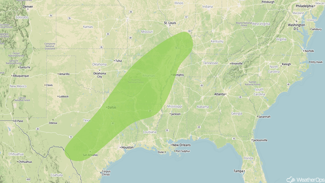 Excessive Rainfall Risk Outline for Tuesday and Wednesday
A Look Ahead
The risk for excessive rainfall will continue for the Ozarks into the Mid Mississippi Valley Thursday into Friday. Two day rainfall totals of 2-4 inches with locally higher amounts are expected. This may lead to flooding and excessive runoff. Wintry precipitation may develop across portions of the Plains and Midwest on Thursday. While there is some uncertainty in the forecast, overall accumulations are expected to be light.
That is a brief look at current weather hazards. We can provide you site-specific weather forecast information to protect your staff and assets and to assess your weather risk. Try a 7-day demo right away and learn how timely precision weather information can enhance your bottom line.
