


by David Moran, on Aug 27, 2018 11:04:30 AM
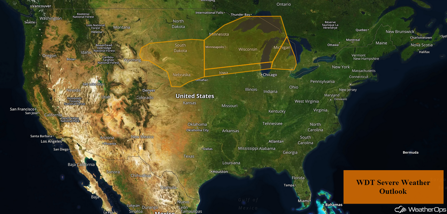
A slow moving cold front will be the focus for the development of thunderstorms from the Midwest to the Great Lakes on Monday. Some of this activity may produce excessive rainfall across the Great Lakes. Thunderstorms are forecast across the High and Central Plains as an upper level trough moves across the region.
- Thunderstorms from the Midwest to the Great Lakes on Monday
- Excessive Rainfall Monday across the Great Lakes
- Risk for Thunderstorms across the High and Central Plains on Monday
- Thunderstorm Potential Tuesday from the Central Plains to New England
- Excessive Rainfall for the Southern Great Lakes on Tuesday
- Potential for Thunderstorms Wednesday from the Missouri River Valley into New England
US Hazards
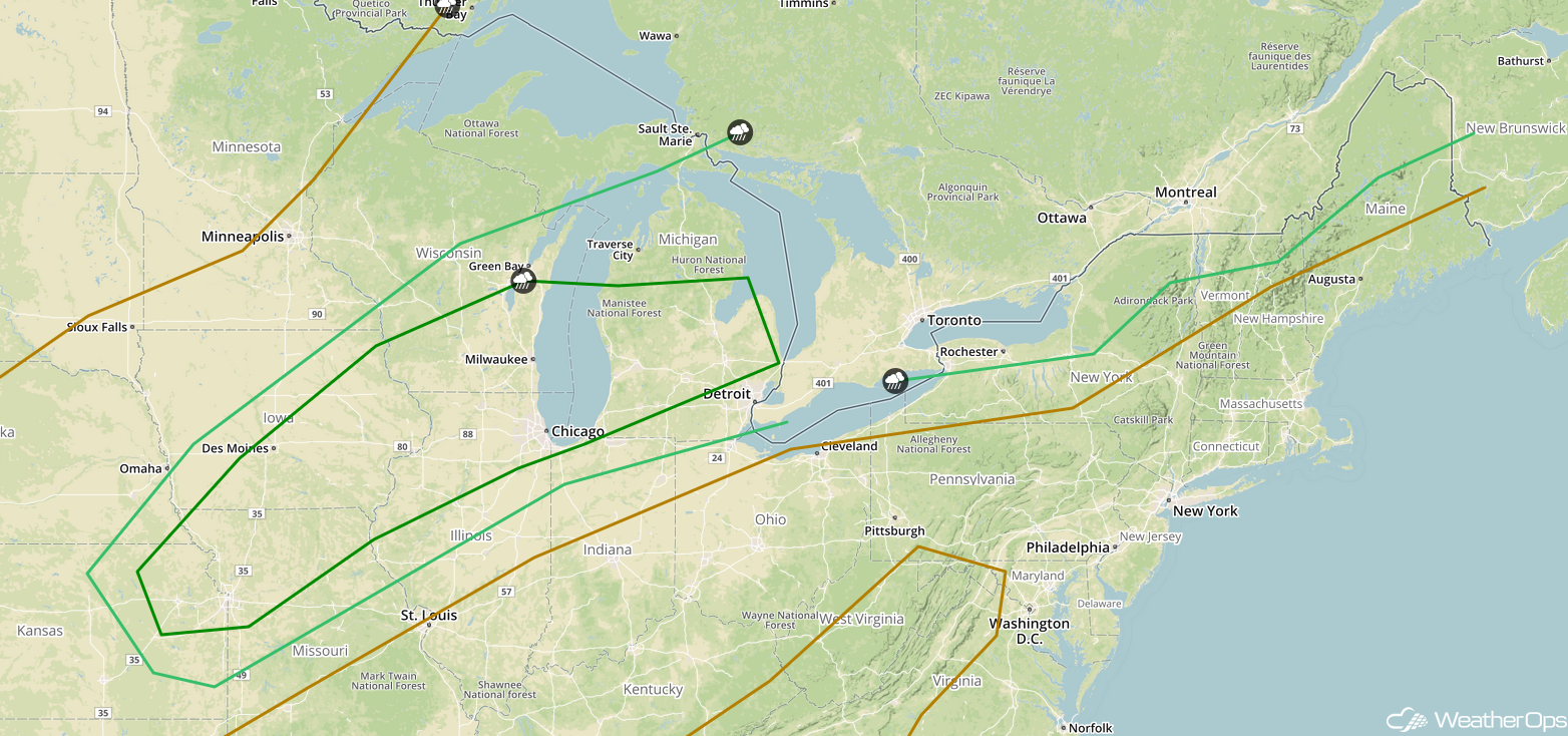
Thunderstorms from the Midwest to the Great Lakes on Monday
Ongoing morning shower and thunderstorm activity will be tracking east to northeastward across the Great Lakes; most, if not all, of this activity, should remain below severe limits. Going into the afternoon, instability will build to the south of a slow moving cold front across the Central Plains northeastward into the Great Lakes. This instability, combined with strong wind shear, will allow for the development of scattered showers and thunderstorms across the Midwest this afternoon. Some of these storms may become strong to severe. Large hail, damaging winds, and tornadoes will all be potential hazards with these storms. As this activity forms clusters and tracks eastward into the Great Lakes overnight, damaging winds will become the primary hazard.
Major Cities in Region: Sioux Falls, SD, Des Moines, IA, Minneapolis, MN, Wausau, MI, Green Bay, WI, Traverse City, MI
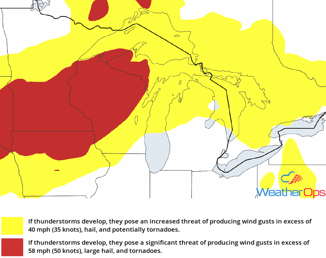
Thunderstorm Risk for Monday
Excessive Rainfall Monday across the Great Lakes
In addition to the thunderstorm risk described above, there will be a risk for excessive rainfall across the Great Lakes. Rainfall amounts of 1-2 inches with locally higher amounts in excess of 3 inches are expected. Given rainfall from previous days, there will be an increased risk for excessive runoff and flash flooding.
Major Cities in Region: Wausau, WI, Green Bay, WI, Marquette, MI
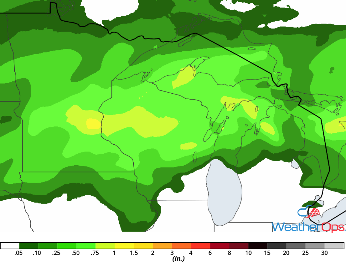
Rainfall Accumulation for Monday
Risk for Thunderstorms across the High and Central Plains on Monday
In the wake of an upper level trough forecast to track eastward across the Black Hills and Central Plains, strong daytime heating will create ample instability. With this instability and strong wind shear in place to the south of a slow moving cold front, scattered strong to severe thunderstorms are expected to develop this afternoon. Storms will initially develop across the High Plains early this afternoon and track eastward into the Central Plains. Damaging winds and large hail will be the primary hazards with these storms.
Major Cities in Region: Rapid City, SD, North Platte, NE, Pierre, SD, Sioux Falls, SD, Minneapolis, MN
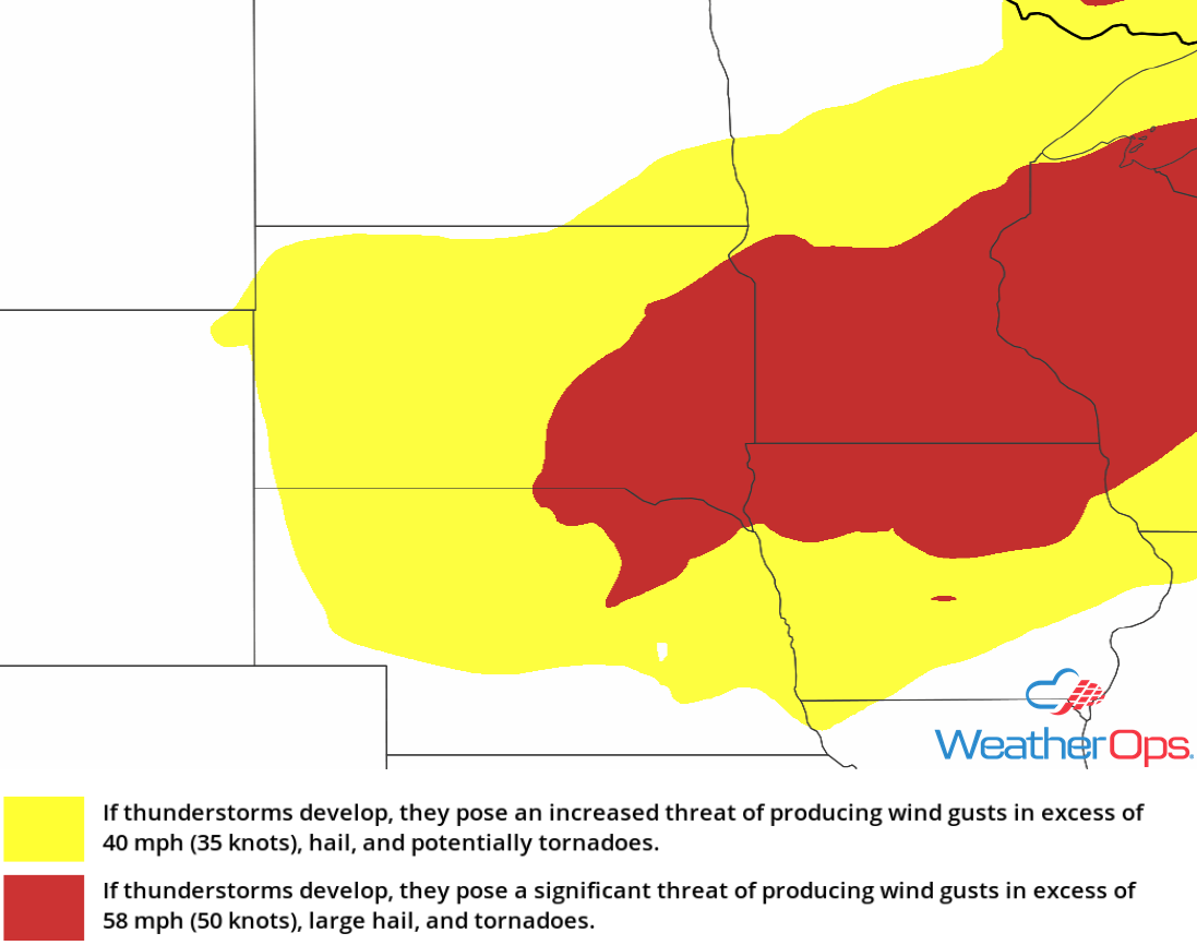
Thunderstorm Risk for Monday
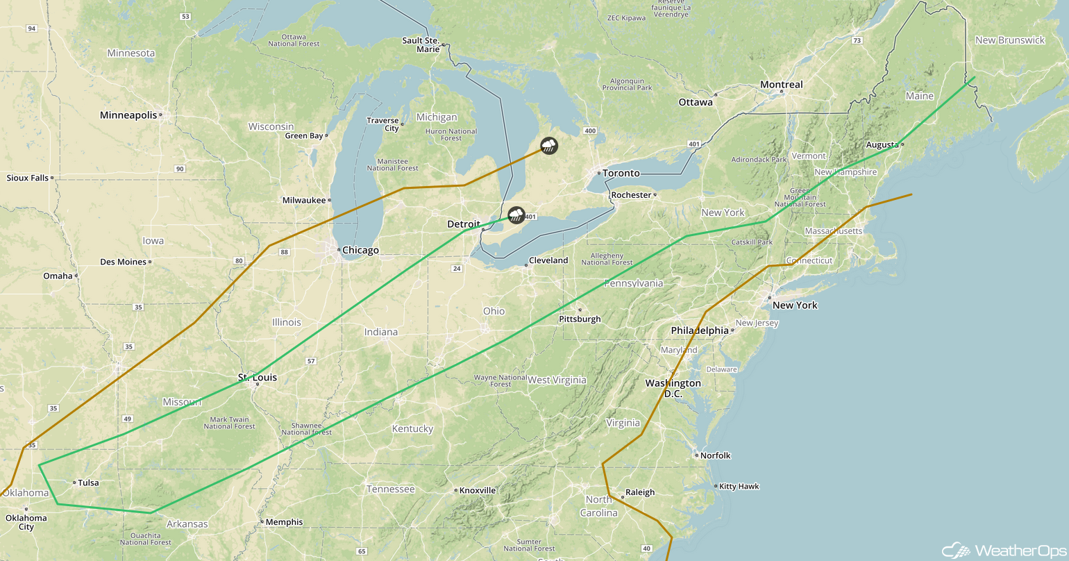
Thunderstorm Potential Tuesday from the Central Plains to New England
A slow moving cold front extending from Ontario and Quebec southwestward into the Central Plains will continue to track southeastward on Tuesday. Ahead of the front, warm moist air will move northward. As daytime heating increases, instability will build along and ahead of the front. Strong wind shear will be in place along the front, allowing for shower and thunderstorm development during the afternoon and evening. These storms are forecast to track eastward to southeastward. Damaging winds, large hail, and isolated tornadoes will be potential hazards with these storms.
Major Cities in Region: Topeka, KS, Kansas City, MO, Des Moines, IA, Green Bay, WI, Milwaukee, WI, Chicago, IL, Detroit, MI, Buffalo, NY, Rochester, NY, Syracuse, NY
SPC Convective Outlook for Tuesday
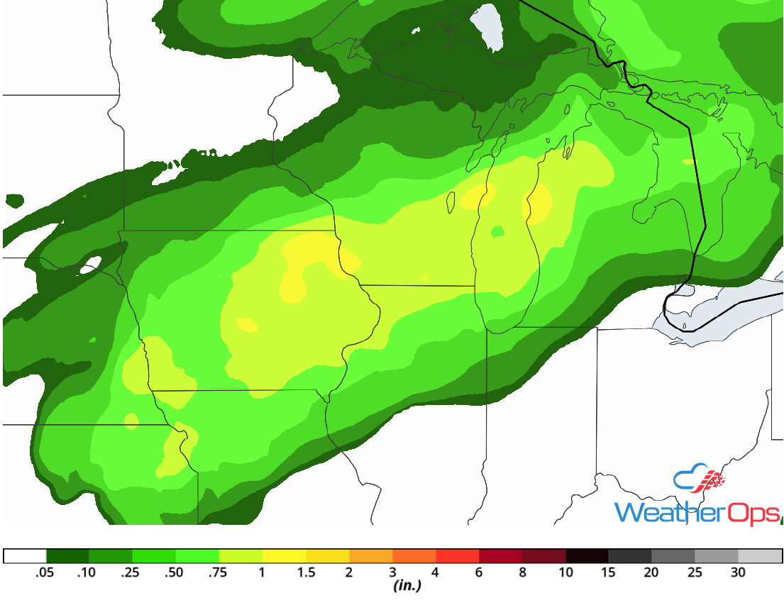
Excessive Rainfall for the Southern Great Lakes on Tuesday
Some of the thunderstorm activity described above will have the ability to produce excessive rainfall across the Southern Great Lakes. Widespread rainfall amounts of 1-2 inches with locally higher amounts of 3 inches are forecast. Given the heavy rainfall that has already fallen, there will be a chance for widespread flooding and excessive runoff.
Major Cities in Region: Madison, WI, Milwaukee, WI
Rainfall Accumulation for Tuesday
Potential for Thunderstorms Wednesday from the Missouri River Valley into New England
A slow moving cold front stretching from eastern Quebec southwestward across the Great Lakes and into the Missouri River Valley will continue to track southeastward on Wednesday. Ahead of this front, instability may build across portions of the Northeast southwestward through the Ohio Valley and into northeastern Oklahoma. Strong wind shear will also be in place, leading to the development of scattered showers and thunderstorms. Some storms may become strong to severe with damaging winds and hail the primary hazards with the strongest storms.
Major Cities in Region: Tulsa, OK, St. Louis, MO, Indianapolis, IN, Cleveland, Rochester, NY, Syracuse, NY, Albany, NY, Burlington, VT, Augusta, ME
SPC Convective Outlook for Wednesday
A Look Ahead
Showers and thunderstorms will extend from the Northeast southwestward into the Missouri Valley on Thursday ahead of a cold front. By Friday, a cold front may allow for the development of thunderstorms across the Upper Midwest into the Great Lakes. Thunderstorms are forecast to develop from the Great Lakes into the Plains on Saturday. Light showers may move across the Ohio Valley Sunday.
